Burnaby Lake Pilot Dredging Project
https://search.heritageburnaby.ca/link/archivedescription91710
- Repository
- City of Burnaby Archives
- Date
- August 1999 - September 1999
- Collection/Fonds
- Doreen Lawson fonds
- Description Level
- File
- Physical Description
- 19 photographs : col. slides ; 35 mm
- Scope and Content
- File consists of photographs documenting the Burnaby Lake Pilot Dredging Project undertaken by the City of Burnaby between August 20 and September 16, 1999. Photographs depict silt-laded water in Still Creek prior to the dredging, mechanical dredging equipment on land and in use on the lake, and t…
- Repository
- City of Burnaby Archives
- Date
- August 1999 - September 1999
- Collection/Fonds
- Doreen Lawson fonds
- Physical Description
- 19 photographs : col. slides ; 35 mm
- Description Level
- File
- Record No.
- 618-029
- Access Restriction
- No restrictions
- Reproduction Restriction
- No restrictions
- Accession Number
- 2015-15
- Scope and Content
- File consists of photographs documenting the Burnaby Lake Pilot Dredging Project undertaken by the City of Burnaby between August 20 and September 16, 1999. Photographs depict silt-laded water in Still Creek prior to the dredging, mechanical dredging equipment on land and in use on the lake, and the adjacent water treatment facility. Also contained in the file are photographs of Deputy Director of Engineering, Lambert Chu, speaking at the dredging site and vials containing two water samples: one clear and one opaque with brown sediment.
- Media Type
- Photograph
- Photographer
- Lawson, Doreen A.
- Notes
- Title based on contents of photographs
- Geographic Access
- Burnaby Lake
- Still Creek
- Historic Neighbourhood
- Burnaby Lake (Historic Neighbourhood)
- Planning Study Area
- Burnaby Lake Area
Images


Oakland's Containment Ponds
https://search.heritageburnaby.ca/link/archivedescription91708
- Repository
- City of Burnaby Archives
- Date
- June 11, 1994
- Collection/Fonds
- Doreen Lawson fonds
- Description Level
- File
- Physical Description
- 20 photographs : col. slides ; 35 mm
- Scope and Content
- File consists of photographs of the containment ponds located on Oakland Street. Photographs depict the shallow ponds and surrounding area, as well as concrete storm drains and a raised wooden walkway and its supports. The creek adjacent to the ponds has not been identified.
- Repository
- City of Burnaby Archives
- Date
- June 11, 1994
- Collection/Fonds
- Doreen Lawson fonds
- Physical Description
- 20 photographs : col. slides ; 35 mm
- Description Level
- File
- Record No.
- 618-026
- Access Restriction
- No restrictions
- Reproduction Restriction
- No restrictions
- Accession Number
- 2015-15
- Scope and Content
- File consists of photographs of the containment ponds located on Oakland Street. Photographs depict the shallow ponds and surrounding area, as well as concrete storm drains and a raised wooden walkway and its supports. The creek adjacent to the ponds has not been identified.
- Media Type
- Photograph
- Photographer
- Lawson, Doreen A.
- Notes
- Transcribed title
- Title transcribed from note on recto of slide frame of photograph 618-026-19
- Geographic Access
- Oakland Street
Images

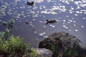
Deer Lake algae and Burnaby Lake Mountain Parkway
https://search.heritageburnaby.ca/link/archivedescription91576
- Repository
- City of Burnaby Archives
- Date
- 1995-1998
- Collection/Fonds
- Doreen Lawson fonds
- Description Level
- File
- Physical Description
- 30 photographs : col. slides ; 35 mm
- Scope and Content
- File consists of photographs of Deer Lake algae, Burnaby Lake Mountain Parkway, and construction at an unidentified waterway. The file also contains two photographs of an unidentified young man sitting in a canoe with his arm outstretched beside an oar, which stands upright in the water without as…
- Repository
- City of Burnaby Archives
- Date
- 1995-1998
- Collection/Fonds
- Doreen Lawson fonds
- Physical Description
- 30 photographs : col. slides ; 35 mm
- Description Level
- File
- Record No.
- 605-009
- Access Restriction
- No restrictions
- Reproduction Restriction
- No restrictions
- Accession Number
- 2003-30
- Scope and Content
- File consists of photographs of Deer Lake algae, Burnaby Lake Mountain Parkway, and construction at an unidentified waterway. The file also contains two photographs of an unidentified young man sitting in a canoe with his arm outstretched beside an oar, which stands upright in the water without assistance.
- Names
- Lawson, Doreen A.
- Media Type
- Photograph
- Photographer
- Lawson, Doreen A.
- Notes
- Transcribed title
- Title transcribed from file photographs were originally housed in
- Photographs were originally housed within file MSS071-017
- Photographs 605-009-1 : 605-009-11 depict Deer Lake algae
- Photographs 605-009-12 : 605-009-22 depict Burnaby Mountain Highway
- Historic Neighbourhood
- Burnaby Lake (Historic Neighbourhood)
- Planning Study Area
- Oakalla Area
Images

![Eagle Creek treehouse, [between 1980 and 2001] thumbnail](/media/hpo/_Data/_Archives_Images/_Unrestricted/600/618-022-1.jpg?width=280)
Eagle Creek treehouse
https://search.heritageburnaby.ca/link/archivedescription91704
- Repository
- City of Burnaby Archives
- Date
- [between 1980 and 2001]
- Collection/Fonds
- Doreen Lawson fonds
- Description Level
- File
- Physical Description
- 5 photographs : col. ; 15 cm x 10 cm
- Scope and Content
- File consists of photographs of a rustic two-storey treehouse located in the forest at Eagle Creek. The treehouse is triangular in shape and constructed around three evergreen trees. The file also contains one photograph of a broken tree stump.
- Repository
- City of Burnaby Archives
- Date
- [between 1980 and 2001]
- Collection/Fonds
- Doreen Lawson fonds
- Physical Description
- 5 photographs : col. ; 15 cm x 10 cm
- Description Level
- File
- Record No.
- 618-022
- Access Restriction
- No restrictions
- Reproduction Restriction
- No restrictions
- Accession Number
- 2015-15
- Scope and Content
- File consists of photographs of a rustic two-storey treehouse located in the forest at Eagle Creek. The treehouse is triangular in shape and constructed around three evergreen trees. The file also contains one photograph of a broken tree stump.
- Subjects
- Plants - Trees
- Media Type
- Photograph
- Photographer
- Lawson, Doreen A.
- Notes
- Title based on contents of photographs
- Note in black in on verso of photographs 618-022-1 : 618-022-4 reads: "Bby. Mtn. Parkway [at] Curtis / Eagle Creek, Upper Reaches / East Fork"
- Note in black in on verso of photograph 618-022-5 reads: "Bby. Mtn. Parkway / Eagle Creek, Upper Reaches"
- Geographic Access
- Eagle Creek
- Planning Study Area
- Sperling-Broadway Area
Images
![Eagle Creek treehouse, [between 1980 and 2001] thumbnail](/media/hpo/_Data/_Archives_Images/_Unrestricted/600/618-022-1.jpg)
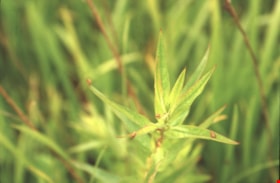
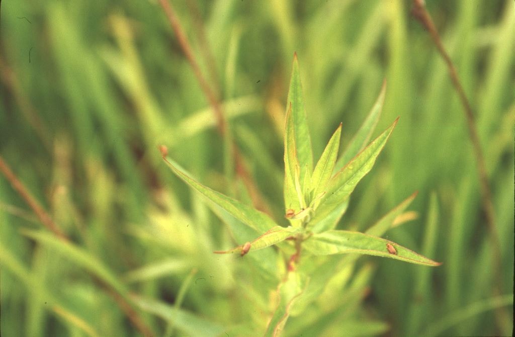
Planting PULO Beetles, Bby. Lake
https://search.heritageburnaby.ca/link/archivedescription91698
- Repository
- City of Burnaby Archives
- Date
- August 28, 1995
- Collection/Fonds
- Doreen Lawson fonds
- Description Level
- File
- Physical Description
- 17 photographs : col. slides ; 35 mm
- Scope and Content
- File consists photographs of leaf-eating beetles being planted in Burnaby Lake. Beetles were released around the lake in order to reduce the population of purple loosestrife in the wetlands. Photographs depict a team of four individuals travelling around the lake by canoe, releasing the beetles f…
- Repository
- City of Burnaby Archives
- Date
- August 28, 1995
- Collection/Fonds
- Doreen Lawson fonds
- Physical Description
- 17 photographs : col. slides ; 35 mm
- Description Level
- File
- Record No.
- 618-016
- Access Restriction
- No restrictions
- Reproduction Restriction
- No restrictions
- Accession Number
- 2015-15
- Scope and Content
- File consists photographs of leaf-eating beetles being planted in Burnaby Lake. Beetles were released around the lake in order to reduce the population of purple loosestrife in the wetlands. Photographs depict a team of four individuals travelling around the lake by canoe, releasing the beetles from white styrofoam containers, and beetles on foliage.
- Media Type
- Photograph
- Photographer
- Lawson, Doreen A.
- Notes
- Transcribed title
- Title transcribed from label on original slide sheets
- Geographic Access
- Burnaby Lake
- Historic Neighbourhood
- Burnaby Lake (Historic Neighbourhood)
- Planning Study Area
- Burnaby Lake Area
Images