More like 'Cariboo Cloverleaf, Government Road and Gaglardi Way'
Narrow Results By
Subject
- Aerial Photographs 2
- Buildings - Commercial 1
- Buildings - Industrial - Factories 1
- Buildings - Residential - Apartments 2
- Construction 4
- Construction - Road Construction 2
- Construction Tools and Equipment 1
- Geographic Features - Roads 1
- Land Clearing 1
- Occupations - Labourers 1
- Officials - Elected Officials 1
![Stormont Overpass, [1978] thumbnail](/media/hpo/_Data/_Archives_Images/_Unrestricted/480/480-275.jpg?width=280)
Stormont Overpass
https://search.heritageburnaby.ca/link/archivedescription45380
- Repository
- City of Burnaby Archives
- Date
- [1978]
- Collection/Fonds
- Columbian Newspaper collection
- Description Level
- Item
- Physical Description
- 1 photograph : b&w ; 16 x 24 cm
- Scope and Content
- Aerial photograph of Stormont Overpass which would provide a direct link from the Trans Canada Highway (previously named the 401 Freeway) to the Lougheed Highway and Simon Fraser University. This was taken when the excavation work was completed, and paving still need to be done.
- Repository
- City of Burnaby Archives
- Date
- [1978]
- Collection/Fonds
- Columbian Newspaper collection
- Physical Description
- 1 photograph : b&w ; 16 x 24 cm
- Description Level
- Item
- Record No.
- 480-275
- Access Restriction
- No restrictions
- Reproduction Restriction
- No restrictions
- Accession Number
- 2003-02
- Scope and Content
- Aerial photograph of Stormont Overpass which would provide a direct link from the Trans Canada Highway (previously named the 401 Freeway) to the Lougheed Highway and Simon Fraser University. This was taken when the excavation work was completed, and paving still need to be done.
- Media Type
- Photograph
- Photographer
- King, Basil
- Notes
- Title based on contents of photograph
- Note on verso of photograph reads: "One of the biggest Highways"
- Geographic Access
- Cariboo Road
- Gaglardi Way
- Trans Canada Highway
- Historic Neighbourhood
- Burquitlam (Historic Neighbourhood)
- Planning Study Area
- Burnaby Lake Area
- Cameron Area
Images
![Stormont Overpass, [1978] thumbnail](/media/hpo/_Data/_Archives_Images/_Unrestricted/480/480-275.jpg)

Widening of Scott Road
https://search.heritageburnaby.ca/link/archivedescription56677
- Repository
- City of Burnaby Archives
- Date
- March 1976, published March 24, 1976
- Collection/Fonds
- Columbian Newspaper collection
- Description Level
- Item
- Physical Description
- 1 photograph : b&w ; 7.5 x 14 cm
- Scope and Content
- Photograph of the process of widening Scott Road in Surrey BC. The process was undertaken by the provincial government. Citizens were upset as this process included cutting down century-old trees (stumps of these former trees are visible in this photograph).
- Repository
- City of Burnaby Archives
- Date
- March 1976, published March 24, 1976
- Collection/Fonds
- Columbian Newspaper collection
- Physical Description
- 1 photograph : b&w ; 7.5 x 14 cm
- Description Level
- Item
- Record No.
- 480-531
- Access Restriction
- No restrictions
- Reproduction Restriction
- No restrictions
- Accession Number
- 2003-02
- Scope and Content
- Photograph of the process of widening Scott Road in Surrey BC. The process was undertaken by the provincial government. Citizens were upset as this process included cutting down century-old trees (stumps of these former trees are visible in this photograph).
- Media Type
- Photograph
- Photographer
- King, Basil
- Notes
- Title based on contents of photograph
- Newspaper clipping attached to verso of photograph reads: "Road-widening on Scott Rd. in Surrey has taken its toll of old trees."
Images


MacInnis Place and Lougheed Village
https://search.heritageburnaby.ca/link/archivedescription45407
- Repository
- City of Burnaby Archives
- Date
- March 1976
- Collection/Fonds
- Columbian Newspaper collection
- Description Level
- Item
- Physical Description
- 1 photograph : b&w ; 14 x 19.5 cm
- Scope and Content
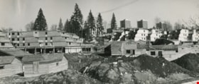
- Aerial photograph of MacInnis Place with Lougheed Village in behind. MacInnis Place housing development was constructed with the intent of having 25% of its suites rented at a reduced cost to low income earners.
- Repository
- City of Burnaby Archives
- Date
- March 1976
- Collection/Fonds
- Columbian Newspaper collection
- Physical Description
- 1 photograph : b&w ; 14 x 19.5 cm
- Description Level
- Item
- Record No.
- 480-302
- Access Restriction
- No restrictions
- Reproduction Restriction
- No restrictions
- Accession Number
- 2003-02
- Scope and Content
- Aerial photograph of MacInnis Place with Lougheed Village in behind. MacInnis Place housing development was constructed with the intent of having 25% of its suites rented at a reduced cost to low income earners.
- Subjects
- Aerial Photographs
- Media Type
- Photograph
- Photographer
- King, Basil
- Notes
- Title based on contents of photograph
- Historic Neighbourhood
- Burquitlam (Historic Neighbourhood)
- Planning Study Area
- Cameron Area
Images

Construction of an office complex
https://search.heritageburnaby.ca/link/archivedescription45419
- Repository
- City of Burnaby Archives
- Date
- April 1977
- Collection/Fonds
- Columbian Newspaper collection
- Description Level
- Item
- Physical Description
- 1 photograph : b&w ; 12.5 x 19.5 cm
- Scope and Content
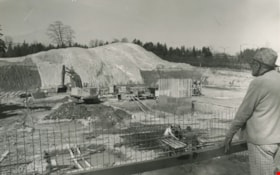
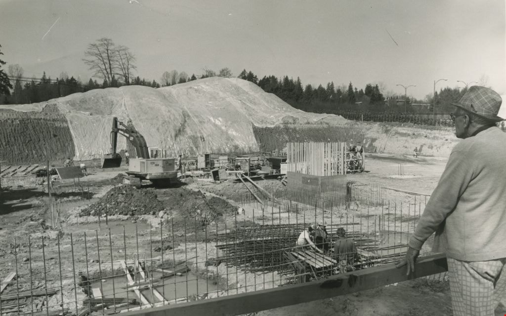
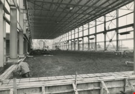
- Photograph of the site of the first office complex built in Burnaby by Marathon Realty just as construction began. A man in a plaid fedora stands to the right, watching the men work below. The site is situated across the street from the Municipal Hall on Canada Way, and consists of a number buildin…
- Repository
- City of Burnaby Archives
- Date
- April 1977
- Collection/Fonds
- Columbian Newspaper collection
- Physical Description
- 1 photograph : b&w ; 12.5 x 19.5 cm
- Description Level
- Item
- Record No.
- 480-314
- Access Restriction
- No restrictions
- Reproduction Restriction
- No restrictions
- Accession Number
- 2003-02
- Scope and Content
- Photograph of the site of the first office complex built in Burnaby by Marathon Realty just as construction began. A man in a plaid fedora stands to the right, watching the men work below. The site is situated across the street from the Municipal Hall on Canada Way, and consists of a number buildings.
- Subjects
- Buildings - Commercial
- Construction
- Names
- Marathon Realty
- Media Type
- Photograph
- Photographer
- King, Basil
- Notes
- Title based on contents of photograph
- Newspaper clipping attached to verso of photograph reads: "NEW COMPLEX NOW UNDERWAY A giant hole and a pile of earth are all that mark the site of a new Burnaby office complex being built on Edgar Avenue across from the Municipal Hall. the project is being built by Marathon Realty, the real estate arm of Canadian Pacific."
- Geographic Access
- Canada Way
- Historic Neighbourhood
- Burnaby Lake (Historic Neighbourhood)
- Planning Study Area
- Douglas-Gilpin Area
Images
Construction of MacInnis Place
https://search.heritageburnaby.ca/link/archivedescription45408
- Repository
- City of Burnaby Archives
- Date
- March 1976
- Collection/Fonds
- Columbian Newspaper collection
- Description Level
- Item
- Physical Description
- 1 photograph : b&w ; 10 x 24.5 cm
- Scope and Content
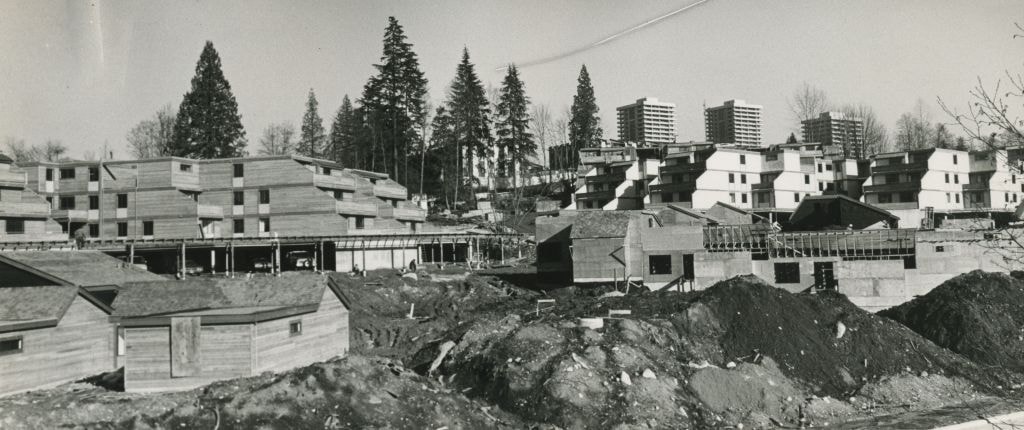
- Photograph of the construction of MacInnis Place in Burnaby. This housing development was constructed with the intent of having 25% of its suites rented at a reduced cost to low income earners.
- Repository
- City of Burnaby Archives
- Date
- March 1976
- Collection/Fonds
- Columbian Newspaper collection
- Physical Description
- 1 photograph : b&w ; 10 x 24.5 cm
- Description Level
- Item
- Record No.
- 480-303
- Access Restriction
- No restrictions
- Reproduction Restriction
- No restrictions
- Accession Number
- 2003-02
- Scope and Content
- Photograph of the construction of MacInnis Place in Burnaby. This housing development was constructed with the intent of having 25% of its suites rented at a reduced cost to low income earners.
- Names
- MacInnis Place
- Media Type
- Photograph
- Photographer
- King, Basil
- Notes
- Title based on contents of photograph
- Geographic Access
- Keswick Avenue
- Historic Neighbourhood
- Burquitlam (Historic Neighbourhood)
- Planning Study Area
- Cameron Area
Images

Construction of MacInnis Place
https://search.heritageburnaby.ca/link/archivedescription45409
- Repository
- City of Burnaby Archives
- Date
- March 1976
- Collection/Fonds
- Columbian Newspaper collection
- Description Level
- Item
- Physical Description
- 1 photograph : b&w ; 11.5 x 24.5 cm
- Scope and Content
- Photograph of the construction of MacInnis Place in Burnaby. This housing development was constructed with the intent of having 25% of its suites rented at a reduced cost to low income earners.
- Repository
- City of Burnaby Archives
- Date
- March 1976
- Collection/Fonds
- Columbian Newspaper collection
- Physical Description
- 1 photograph : b&w ; 11.5 x 24.5 cm
- Description Level
- Item
- Record No.
- 480-304
- Access Restriction
- No restrictions
- Reproduction Restriction
- No restrictions
- Accession Number
- 2003-02
- Scope and Content
- Photograph of the construction of MacInnis Place in Burnaby. This housing development was constructed with the intent of having 25% of its suites rented at a reduced cost to low income earners.
- Names
- MacInnis Place
- Media Type
- Photograph
- Photographer
- King, Basil
- Notes
- Title based on contents of photograph
- Geographic Access
- Keswick Avenue
- Historic Neighbourhood
- Burquitlam (Historic Neighbourhood)
- Planning Study Area
- Cameron Area
Images

Construction of the Steel Service Centre
https://search.heritageburnaby.ca/link/archivedescription45612
- Repository
- City of Burnaby Archives
- Date
- April 1976
- Collection/Fonds
- Columbian Newspaper collection
- Description Level
- Item
- Physical Description
- 1 photograph : b&w ; 14 x 19.5 cm
- Scope and Content
- Photograph of the construction of the Dominion Bridge Steel Service Centre. Dominion Bridge Co. closed down its Burnaby fabricating plant which employed 350 workers and opened this in Delta which employed only 50 of those workers, putting 300 employess out of work.
- Repository
- City of Burnaby Archives
- Date
- April 1976
- Collection/Fonds
- Columbian Newspaper collection
- Physical Description
- 1 photograph : b&w ; 14 x 19.5 cm
- Description Level
- Item
- Record No.
- 480-506
- Access Restriction
- No restrictions
- Reproduction Restriction
- No restrictions
- Accession Number
- 2003-02
- Scope and Content
- Photograph of the construction of the Dominion Bridge Steel Service Centre. Dominion Bridge Co. closed down its Burnaby fabricating plant which employed 350 workers and opened this in Delta which employed only 50 of those workers, putting 300 employess out of work.
- Names
- Dominion Bridge Company
- Media Type
- Photograph
- Photographer
- King, Basil
- Notes
- Title based on contents of photograph
- Newspaper clipping attached to verso of photograph reads: "More than 600 tons of structural steel are being assembled on Annacis Island to build the new Dominion Bridge Steel Service Centre. Construction which started in the Fall of 1975 will be completed by the end of June."
Images

Health Minister Dennis Cocke
https://search.heritageburnaby.ca/link/archivedescription45340
- Repository
- City of Burnaby Archives
- Date
- May 6, 1975
- Collection/Fonds
- Columbian Newspaper collection
- Description Level
- Item
- Physical Description
- 1 photograph : b&w ; 24 x 10 cm
- Scope and Content
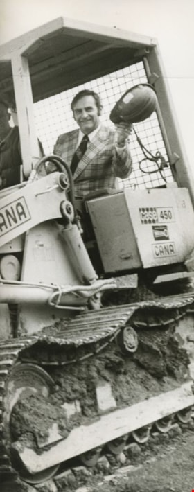
- Photograph of Health Minister Dennis Cocke wearing a suit and waving his hard hat at the camera while he sits in the bulldozer that "broke the ground" at the Burnaby General Hospital construction site. Cocke was a provincial minister of health in Dave Barrett's New Democratic Party government, whic…
- Repository
- City of Burnaby Archives
- Date
- May 6, 1975
- Collection/Fonds
- Columbian Newspaper collection
- Physical Description
- 1 photograph : b&w ; 24 x 10 cm
- Description Level
- Item
- Record No.
- 480-235
- Access Restriction
- No restrictions
- Reproduction Restriction
- No restrictions
- Accession Number
- 2003-02
- Scope and Content
- Photograph of Health Minister Dennis Cocke wearing a suit and waving his hard hat at the camera while he sits in the bulldozer that "broke the ground" at the Burnaby General Hospital construction site. Cocke was a provincial minister of health in Dave Barrett's New Democratic Party government, which ran the province from 1972 to 1975, and was the Member of the Legislative Assembly (MLA) representing New Westminster from 1969 to 1986.
- Media Type
- Photograph
- Photographer
- King, Basil
- Notes
- Title based on contents of photograph
- Geographic Access
- Kincaid Street
- Street Address
- 3935 Kincaid Street
- Historic Neighbourhood
- Broadview (Historic Neighbourhood)
- Planning Study Area
- Cascade-Schou Area
Images
