Narrow Results By
Cunningham and Montgomery families
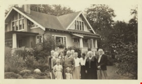
https://search.heritageburnaby.ca/link/archivedescription77526
- Repository
- City of Burnaby Archives
- Date
- August 1937
- Collection/Fonds
- Montgomery family fonds
- Description Level
- Item
- Physical Description
- 1 photograph : b&w ; 7 x 12 cm
- Scope and Content
- Photograph of members of the Cunningham and Montgomery families standing in front of Fred and Edna Cunningham's house on Douglas Road (this house was given heritage designation by the City of Burnaby in 1996). Fred Cunningham Junior is standing at the back on the far left, Claire Carpenter is in fr…
- Repository
- City of Burnaby Archives
- Date
- August 1937
- Collection/Fonds
- Montgomery family fonds
- Physical Description
- 1 photograph : b&w ; 7 x 12 cm
- Description Level
- Item
- Record No.
- 554-001
- Access Restriction
- No restrictions
- Reproduction Restriction
- Reproduce for fair dealing purposes only
- Accession Number
- 2013-14
- Scope and Content
- Photograph of members of the Cunningham and Montgomery families standing in front of Fred and Edna Cunningham's house on Douglas Road (this house was given heritage designation by the City of Burnaby in 1996). Fred Cunningham Junior is standing at the back on the far left, Claire Carpenter is in front of him holding young Margery Kathleen "Kathleen" Montgomery (later Green) at her waist. Marjorie Montgomery is behind and to the right of them both. Beside Kathleen is her sister Janet Montgomery (later Fernau). Fred Cunningham has his hand on Janet's shoulder with Harold Carpenter visible in behind Fred. Dot Clark is standing between Fred and his wife Edna Cunningham who has her head turned away from the camera. Elsepth Montgomery is to the right of Edna and Reg Clark is last, on the far right.
- Names
- Cunningham, Edna Elizabeth
- Cunningham, Fred
- Cunningham, Fred Jr
- Montgomery, Marjorie Elizabeth Carpenter
- Carpenter, Claire
- Green, Margery Kathleen "Kathleen" Montgomery
- Fernau, Janet Elspeth Montgomery
- Carpenter, Harold
- Clark, Dot
- Montgomery, Elsepth
- Clark, Reg
- Media Type
- Photograph
- Photographer
- Montgomery, Samuel Clifford "Monty"
- Notes
- Title based on contents of photograph
- Note in pencil on verso of photograph reads: "3555 Douglas Road / 1979 - All gone except Auntie - / Kath - + Janet -"
- 1 duplicate (jpeg) accompanying
- Street Address
- 3555 Douglas Road
- Historic Neighbourhood
- Burnaby Lake (Historic Neighbourhood)
- Planning Study Area
- Douglas-Gilpin Area
Images

![Subdivision plans in New Westminster District Group 1 – Burnaby
, [1893-1910] thumbnail](/media/hpo/_Data/_BVM_Cartographic_Material/1977/1977_0093_0016a_001.jpg?width=280)
Subdivision plans in New Westminster District Group 1 – Burnaby
https://search.heritageburnaby.ca/link/museumdescription6985
- Repository
- Burnaby Village Museum
- Date
- [1893-1910]
- Collection/Fonds
- Burnaby Village Museum Map collection
- Description Level
- File
- Physical Description
- 4 plans : blueprint ink on paper mounted on 2 sides of cardboard 76 x 102 cm
- Scope and Content
- Item consists of a large board of two New Westminster District Gp 1 - subdivision plans mounted on one side and two New Westminster District Gp 1 - subdivision plans mounted on the other side. Side A: 1. Blueprint "Plan / of Subdivision / of / Lot 6 / Group One / New Westminster District / Scale…
- Repository
- Burnaby Village Museum
- Collection/Fonds
- Burnaby Village Museum Map collection
- Description Level
- File
- Physical Description
- 4 plans : blueprint ink on paper mounted on 2 sides of cardboard 76 x 102 cm
- Material Details
- Scales [between 1:1584 and 1:3960]
- Index number on edge of board reads: "16"
- Scope and Content
- Item consists of a large board of two New Westminster District Gp 1 - subdivision plans mounted on one side and two New Westminster District Gp 1 - subdivision plans mounted on the other side. Side A: 1. Blueprint "Plan / of Subdivision / of / Lot 6 / Group One / New Westminster District / Scale 5 chs = 1 in. / Map No 748" (Geographic location: Burnaby) 2. Blueprint "Plan / of Subdivision / of a Portion / of / Lot 29 / Group One / New Westminster Dist. / Scale 2 chs = 1 in. / Map No." Name identified in Block H is "Reichenbach" (Geographic location: Burnaby) Side B: 1. Blueprint "Plan / of Subdivision / of North 1/2 of Lot 80 / Group One / New Westminster District / Scale 3 chs = 1 in. / Map No 719" Plan is signed by: "Garden, Hermon & Burwell P.L.S. / Vancouver Jan. 23rd, 1893" (Geographic location: Burnaby) 2. Blueprint "Plan / of Subdivision / of Lot 79, Gr.1 / New Westminster Dist. / Scale 4 chas = 1 in. / Map No 536" Plan is signed by "Garden Hermon & Burwell / Provincial Land Surveyors". (Geographic location: Burnaby)
- Creator
- Garden, Hermon and Burwell
- Accession Code
- HV977.93.16
- Access Restriction
- No restrictions
- Reproduction Restriction
- No known restrictions
- Date
- [1893-1910]
- Media Type
- Cartographic Material
- Historic Neighbourhood
- Edmonds (Historic Neighbourhood)
- Burnaby Lake (Historic Neighbourhood)
- Planning Study Area
- Douglas-Gilpin Area
- Edmonds Area
- Cameron Area
- Scan Resolution
- 300
- Scale
- 72
- Notes
- Title based on contents of file
- Scale is measured in chains. (One chain equals 792 inches)
- The term "Lot" can also refer to a "District Lot”
Images
![Subdivision plans in New Westminster District Group 1 – Burnaby
, [1893-1910] thumbnail](/media/hpo/_Data/_BVM_Cartographic_Material/1977/1977_0093_0016a_001.jpg)
