Narrow Results By
Creator
- Bureau of Post War Rehabilitation and Reconstruction Regional Planning Division 1
- Burnett and McGugan B.C. Land Surveyors, New Westminster 5
- Burnett, David H. 1
- Burnett, Geoffrey K. 6
- Burnett & McGugan, Engineers and Surveyors 9
- Cecil Croker Fox 1
- City of Burnaby 1
- Draper, William Nelson 1
- Frank William Macey 1
- Fred Laughton Townley
- Garden, Hermon and Burwell 3
- Garden, Hermon & Burwell
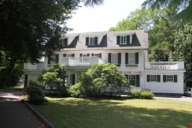
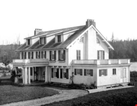
T.O. Townley Estate 'Deerholme'
https://search.heritageburnaby.ca/link/landmark545
- Repository
- Burnaby Heritage Planning
- Description
- The T.O. Townley Estate, 'Deerholme,' is located on a lake front property on the north shore of Deer Lake Park. The main house is a two-and-one-half storey symmetrical-massed wood-frame Colonial Revival structure, with flanking one-storey wings, a side gable roof and a central front entry.
- Associated Dates
- 1913
- Formal Recognition
- Heritage Designation, Community Heritage Register
- Other Names
- Thomas & Frances Townley Estate, Loftus House
- Street View URL
- Google Maps Street View
- Repository
- Burnaby Heritage Planning
- Other Names
- Thomas & Frances Townley Estate, Loftus House
- Geographic Access
- Price Street
- Associated Dates
- 1913
- Formal Recognition
- Heritage Designation, Community Heritage Register
- Enactment Type
- Bylaw No. 9807
- Enactment Date
- 23/11/1992
- Description
- The T.O. Townley Estate, 'Deerholme,' is located on a lake front property on the north shore of Deer Lake Park. The main house is a two-and-one-half storey symmetrical-massed wood-frame Colonial Revival structure, with flanking one-storey wings, a side gable roof and a central front entry.
- Heritage Value
- 'Deerholme' was built as the retirement estate of Lieutenant-Colonel Thomas Owen Townley (1862-1935) and his wife, Frances M. Townley. Townley was a pioneer resident of the Lower Mainland of British Columbia: he served as a lawyer, Registrar of Land Titles for New Westminster District and Mayor of Vancouver for one term in 1901. Built in 1913, this is one of the most significant of the Deer Lake estate houses and was the last of grand Edwardian era mansions built on the lots surrounding the lake. The area had been opened up for development two years earlier by the construction of the British Columbia Electric Railway Interurban Line. The estate speaks of a gracious way of life achieved by society's elite during the Edwardian era, supported by the use of domestic servants. Grand in scale, architecturally sophisticated and set in a bucolic landscape, this residence demonstrates the social status of the owner in the privileged classes of the rapidly developing social structure of Burnaby. The house is also significant as one of the earliest designs by the son of Thomas and Frances Townley, architect Fred Laughton Townley (1887-1966), who had graduated in architecture in 1911 from the University of Pennsylvania. In this house for his parents, he demonstrated his deft understanding of the American Period Revival styles learned during his schooling in the United States. The prevailing local taste for British-derived architecture dictated that this was a style he was rarely able to use until the Colonial Revival styles became more popular in the 1920s. F.L. Townley was a founding partner in Townley and Matheson, which achieved significant success as one of the most accomplished local architectural firms, culminating in their best-known commission, Vancouver City Hall, 1935-36.
- Defining Elements
- Key elements the define the heritage character of ‘Deerholme’ include its: - integration with its south-sloping lakefront site, which contains many original landscape features (extant rockeries, formal drive, tennis lawn, open fields, and specimen shrubs and trees) - two-and-one-half storey form with flanking one-storey wings - side gable roof with symmetrical shed dormers, three at the front and three at the rear - complex fenestration, including multi-paned wooden-sash double-hung windows, 6-over-1 on the ground floor and 6-over-9 on the second floor, and multi-paned wooden-sash casements in the dormers - pair of prominent exterior brick chimneys on each side elevation, clad with rough-cast stucco up to the roof level, and each with four chimney-pots - rough-cast stucco cladding - design elements typical of the Colonial Revival style, such as composed classical formality, side gable roof and balanced symmetrical massing - exterior architectural elements, such as classical columns, window shutters, fanlight feature window, multi-paned quarter-round windows flanking the chimneys, and projecting square brackets in the gables - superior level of design and craftsmanship throughout, including refined interior woodwork such as fireplaces, interior columned screen between hallway and living room and a staircase with Colonial Revival details - significant mature trees (such as Red Oaks, Silver Maples, and Copper Beech). - original guest house and stables, which survive on an adjacent property at 6176 Price Street
- Historic Neighbourhood
- Burnaby Lake (Historic Neighbourhood)
- Planning Study Area
- Douglas-Gilpin Area
- Architect
- Fred Laughton Townley
- Function
- Primary Current--Estate
- Primary Historic--Estate
- Community
- Burnaby
- Cadastral Identifier
- P.I.D. No. 002-652-111 Legal Description: Parcel 'C' (Explanatory Plan 12891) , Blocks 4 and 5, District Lot 79 Group 1, New Westminster District, Plan 536
- Boundaries
- ‘Deerholme’ is comprised of a single municipally-owned property located at 6110 Price Street, Burnaby.
- Area
- 14,099.52
- Contributing Resource
- Building
- Landscape Feature
- Ownership
- Public (local)
- Other Collection
- City of Vancouver Archives: T.O. Townley Residence, Original Plans, Add. MSS. 1399, Temporary No. 61, Location 920-D
- Documentation
- Heritage Site Files: PC77000 20. City of Burnaby Planning and Building Department, 4949 Canada Way, Burnaby, B.C., V5G 1M2
- Street Address
- 6110 Price Street
- Street View URL
- Google Maps Street View
Images
Subdivision plans in New Westminster District Group 1 – Burnaby, Vancouver and map - Canada Department of Mines
https://search.heritageburnaby.ca/link/museumdescription6994
- Repository
- Burnaby Village Museum
- Date
- 1890-1909
- Collection/Fonds
- Burnaby Village Museum Map collection
- Description Level
- File
- Physical Description
- 1 plan : graphite on paper + 2 plans : black ink on paper + 1 map : col. on paper mounted on 2 sides of cardboard 76 x 102 cm
- Scope and Content
- Item consists of a large board with one New Westminster District subdivision plan mounted on one side and two New Westminster District subdivision plans and one colour map mounted on the other side. Side A: 1. "Plan / of Subdivision of / Blocks 2, 3, 4, 5, 6 / Lot 77 / Group 1 / New Westminster D…
- Repository
- Burnaby Village Museum
- Collection/Fonds
- Burnaby Village Museum Map collection
- Description Level
- File
- Physical Description
- 1 plan : graphite on paper + 2 plans : black ink on paper + 1 map : col. on paper mounted on 2 sides of cardboard 76 x 102 cm
- Material Details
- Scales 1:720 and 1:1200 and 1:.00001578
- Scope and Content
- Item consists of a large board with one New Westminster District subdivision plan mounted on one side and two New Westminster District subdivision plans and one colour map mounted on the other side. Side A: 1. "Plan / of Subdivision of / Blocks 2, 3, 4, 5, 6 / Lot 77 / Group 1 / New Westminster District / BC. / Scale 100 feet = 1 inch", "Deposited 8th day / of April 1890 / Mowileg [sic] / Dist. Regt". Plan is drawn in graphite with annotations: "AB_Parts_lettered_are_lots_in / the_different_subdivisions" / "Owners: / James E. Hall / P.S.Cabilan [sic] by his attorney Joseph Hall / Joseph Hall / Eliza J. Shannon / John Harrison"; "This plan is correct and is prepared under the / provisions of the Land Registry Act" ; signed by: "Gordon Herman & Burwell / Dominion & Provincial Land Surveryors / Vancouver March 19th/90" . Plan is initialed by: "RB" [sic] (in blue pencil crayon) and measures: 99.5 x 65 cm (Geographic location: Burnaby) Side B: 1. Map titled "Canada / Department of Mines / Geological Survey Branch" / "Hon.W Templeton, Minister / A.P. Low, Deputy Minister / R.W. Brock, Acting Director", Vol. XXXI, Plate I / Compiled under the direction of / James White, F.R.G.S. Geographer /Dep. of Interior". Note above map reads: "To illustrate Mr. James Barrowman's report as Delegate at the Excursion - meeting of the Canadian Mining Institute", "The instiitution of Mining Engineers / Transactions 1908 - 1909", "The Mining Institute of Scotland / Transactions 1908-1909". Map identifies minerals and includes a Legend and Scale: 100 miles = 1 inch 2. "Plan / of Subdivision of / Lot 4 / of Subdivision of / Lot 87. Gr. 1 / New Westminster District / Scale 60' = 1in." Plan is initialed by: "RB" [sic] along with a note "also Board / 48" (in blue pencil crayon) (Geographic location: Burnaby) 3. Plan of "Lot 335 / G. 1" west of Boundary Road and north of River Road - Vancouver. (Geographic location: Vancouver)
- Publisher
- The Mining Institute of Scotland
- Geographic Access
- Vancouver
- Accession Code
- HV977.93.25
- Access Restriction
- No restrictions
- Reproduction Restriction
- No known restrictions
- Date
- 1890-1909
- Media Type
- Cartographic Material
- Scan Resolution
- 300
- Scale
- 72
- Notes
- Title based on contents of file
- Scale is measured in feet and miles.
- The term "Lot" often refers to "District Lot"


