![Burnaby Lake, [198-] thumbnail](/media/hpo/_Data/_Archives_Images/_Unrestricted/480/480-873.jpg?width=280)
Burnaby Lake
https://search.heritageburnaby.ca/link/archivedescription45978
- Repository
- City of Burnaby Archives
- Date
- [198-]
- Collection/Fonds
- Columbian Newspaper collection
- Description Level
- Item
- Physical Description
- 1 photograph : b&w ; 12 x 23 cm
- Scope and Content
- Photograph of Burnaby Lake.
- Repository
- City of Burnaby Archives
- Date
- [198-]
- Collection/Fonds
- Columbian Newspaper collection
- Physical Description
- 1 photograph : b&w ; 12 x 23 cm
- Description Level
- Item
- Record No.
- 480-873
- Access Restriction
- No restrictions
- Reproduction Restriction
- Reproduce for fair dealing purposes only
- Accession Number
- 2003-02
- Scope and Content
- Photograph of Burnaby Lake.
- Media Type
- Photograph
- Photographer
- Donnelly, David
- Notes
- Title based on contents of photograph
- Geographic Access
- Burnaby Lake
- Historic Neighbourhood
- Burnaby Lake (Historic Neighbourhood)
- Planning Study Area
- Burnaby Lake Area
Images
![Burnaby Lake, [198-] thumbnail](/media/hpo/_Data/_Archives_Images/_Unrestricted/480/480-873.jpg)
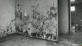
Mold and watermarks
https://search.heritageburnaby.ca/link/archivedescription45406
- Repository
- City of Burnaby Archives
- Date
- August 31, 1981
- Collection/Fonds
- Columbian Newspaper collection
- Description Level
- Item
- Physical Description
- 1 photograph : b&w ; 12.5 x 22.5 cm
- Scope and Content
- Photograph of mold growing on a wall in a basement on Norland Avenue in Burnaby. The owner of the house, Jocelan Wise blames the mold and watermarks on a faulty storm sewer put in by the municipality in 1977.
- Repository
- City of Burnaby Archives
- Date
- August 31, 1981
- Collection/Fonds
- Columbian Newspaper collection
- Physical Description
- 1 photograph : b&w ; 12.5 x 22.5 cm
- Description Level
- Item
- Record No.
- 480-301
- Access Restriction
- No restrictions
- Reproduction Restriction
- No restrictions
- Accession Number
- 2003-02
- Scope and Content
- Photograph of mold growing on a wall in a basement on Norland Avenue in Burnaby. The owner of the house, Jocelan Wise blames the mold and watermarks on a faulty storm sewer put in by the municipality in 1977.
- Media Type
- Photograph
- Photographer
- Battistoni, Peter
- Notes
- Title based on contents of photograph
- Geographic Access
- Norland Avenue
- Historic Neighbourhood
- Burnaby Lake (Historic Neighbourhood)
- Planning Study Area
- Ardingley-Sprott Area
Images

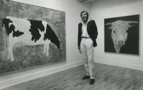
Robin Mayor
https://search.heritageburnaby.ca/link/archivedescription45168
- Repository
- City of Burnaby Archives
- Date
- August 20, 1980, published August 25, 1980
- Collection/Fonds
- Columbian Newspaper collection
- Description Level
- Item
- Physical Description
- 1 photograph : b&w ; 14 x 22.5 cm
- Scope and Content
- Photograph of Robin Mayor standing inbetween two of his paintings at the Burnaby Art Gallery. The painting of the jersey cow on the left is "Linda the Navigator" and the one on the right is "Curly". Both paintings are acrylic and mixed media on canvas.
- Repository
- City of Burnaby Archives
- Date
- August 20, 1980, published August 25, 1980
- Collection/Fonds
- Columbian Newspaper collection
- Physical Description
- 1 photograph : b&w ; 14 x 22.5 cm
- Description Level
- Item
- Record No.
- 480-064
- Access Restriction
- No restrictions
- Reproduction Restriction
- Reproduce for fair dealing purposes only
- Accession Number
- 2003-02
- Scope and Content
- Photograph of Robin Mayor standing inbetween two of his paintings at the Burnaby Art Gallery. The painting of the jersey cow on the left is "Linda the Navigator" and the one on the right is "Curly". Both paintings are acrylic and mixed media on canvas.
- Media Type
- Photograph
- Photographer
- Battistoni, Peter
- Notes
- Title based on contents of photograph
- Newspaper clipping attached to verso of photograph reads: "COWS ARE BEAUTIFUL...Artist Robin Mayor poses with two of his unique cattle pictures at the Burnaby Art Gallery. At left is Linda the Navigator; at right, Curly. Both are acrylics and mixed media on canvas."
- Geographic Access
- Deer Lake Avenue
- Street Address
- 6344 Deer Lake Avenue
- Historic Neighbourhood
- Burnaby Lake (Historic Neighbourhood)
- Planning Study Area
- Douglas-Gilpin Area
Images
