![Subdivision plans in New Westminster District Group 1 – Burnaby
, [1882-1910] thumbnail](/media/hpo/_Data/_BVM_Cartographic_Material/1977/1977_0093_0013a_001.jpg?width=280)
Subdivision plans in New Westminster District Group 1 – Burnaby
https://search.heritageburnaby.ca/link/museumdescription6982
- Repository
- Burnaby Village Museum
- Date
- [1882-1910]
- Collection/Fonds
- Burnaby Village Museum Map collection
- Description Level
- File
- Physical Description
- 4 plans : blueprint on paper mounted on 2 sides of cardboard 76 x 102 cm
- Scope and Content
- Item consists of a large board of two New Westminster District Gp 1 - subdivision plans mounted on one side and two New Westminster District Gp 1 - subdivision plans mounted on the other side. Side A: 1. Blueprint "Plan / of the / Subdivision / of / Lot 98 / G.1, N.W.D. / Scale 4 chs = 1 in. / …
- Repository
- Burnaby Village Museum
- Collection/Fonds
- Burnaby Village Museum Map collection
- Description Level
- File
- Physical Description
- 4 plans : blueprint on paper mounted on 2 sides of cardboard 76 x 102 cm
- Material Details
- Scales [between 1:1584 and 1:3168]
- Index number on edge of board reads: "13"
- Scope and Content
- Item consists of a large board of two New Westminster District Gp 1 - subdivision plans mounted on one side and two New Westminster District Gp 1 - subdivision plans mounted on the other side. Side A: 1. Blueprint "Plan / of the / Subdivision / of / Lot 98 / G.1, N.W.D. / Scale 4 chs = 1 in. / Map No 573" (Geographic location: Burnaby) 2. Blueprint "Plan / of Subdivision of / Lot 157 / Gr.1, New. West. Dist. / Scale 3 chs = 1 in. / Map No. 612". (Geographic location: Burnaby) Side B: 1. Blueprint "Plan / of Subdivision / of a Portion of / Lot 90 / Group One / New Westminster Dist. / Scale 2 chs = 1 in. / Map No. 555". Plan is signed by "Jno Strathern [sic]_P.L.S."n (Geographic location: Burnaby) 2. Blueprint "Subdivision of Lot 31, Group 1. / New Westminster District / As Amended by Order of Court / 1st Sept. 1882 and Numbered 847 / Scale 4 chs = 1in. / Map No 80" (Geographic location: Burnaby)
- Creator
- Stathern, John
- Accession Code
- HV977.93.13
- Access Restriction
- No restrictions
- Reproduction Restriction
- No known restrictions
- Date
- [1882-1910]
- Media Type
- Cartographic Material
- Historic Neighbourhood
- Alta Vista (Historic Neighbourhood)
- Planning Study Area
- Richmond Park Area
- Lakeview-Mayfield Area
- Scan Resolution
- 300
- Scale
- 72
- Notes
- Title based on contents of file
- Scale is measured in chains. (One chain equals 792 inches)
- The term "Lot" can also refer to a "District Lot”
Images
![Subdivision plans in New Westminster District Group 1 – Burnaby
, [1882-1910] thumbnail](/media/hpo/_Data/_BVM_Cartographic_Material/1977/1977_0093_0013a_001.jpg)

![Douglas Road, [1897] (date of original), copied 1978 thumbnail](/media/hpo/_Data/_BVM_Images/1978/1978_0001_0001_001.jpg?width=280)
Douglas Road
https://search.heritageburnaby.ca/link/museumdescription447
- Repository
- Burnaby Village Museum
- Date
- [1897] (date of original), copied 1978
- Collection/Fonds
- Burnaby Village Museum Photograph collection
- Description Level
- Item
- Physical Description
- 1 photograph : b&w ; 20.2 x 25.2 cm print
- Scope and Content
- Photograph of Douglas Road (later renamed in part Canada Way), near Stanley Street. To the right is the Sprott family property, where a few wooden buildings are visible in the cleared area. Charles Sprott, head of the Sprott family, was an important Burnaby politician who was continuously elected t…
- Repository
- Burnaby Village Museum
- Collection/Fonds
- Burnaby Village Museum Photograph collection
- Description Level
- Item
- Physical Description
- 1 photograph : b&w ; 20.2 x 25.2 cm print
- Scope and Content
- Photograph of Douglas Road (later renamed in part Canada Way), near Stanley Street. To the right is the Sprott family property, where a few wooden buildings are visible in the cleared area. Charles Sprott, head of the Sprott family, was an important Burnaby politician who was continuously elected to serve in the municiality as councillor from 1895 to 1903 and as Reeve from 1904 to 1905.
- Subjects
- Geographic Features - Roads
- Land Clearing
- Geographic Access
- Douglas Road
- Canada Way
- Stanley Street
- Accession Code
- HV978.1.1
- Access Restriction
- No restrictions
- Reproduction Restriction
- No known restrictions
- Date
- [1897] (date of original), copied 1978
- Media Type
- Photograph
- Historic Neighbourhood
- Burnaby Lake (Historic Neighbourhood)
- Planning Study Area
- Lakeview-Mayfield Area
- Scan Resolution
- 600
- Scan Date
- 2023-07-25
- Notes
- Title based on contents of photograph
Images
![Douglas Road, [1897] (date of original), copied 1978 thumbnail](/media/hpo/_Data/_BVM_Images/1978/1978_0001_0001_001.jpg)
![Douglas Road, Burnaby, [1908] thumbnail](/media/hpo/_Data/_Archives_Images/_Unrestricted/371/449-009.jpg?width=280)
Douglas Road, Burnaby
https://search.heritageburnaby.ca/link/archivedescription38514
- Repository
- City of Burnaby Archives
- Date
- [1908]
- Collection/Fonds
- Burnaby Historical Society fonds
- Description Level
- Item
- Physical Description
- 1 photograph : sepia postcard ; 8.8 x 14 cm
- Scope and Content
- Photographic postcard taken looking northwest along Douglas Road (now Canada Way) near Stanley Street. Two unidentified people are standing next to a wooden fence running alongside the road (above Lubbock's Creek) and a number of houses (including the Sprott house) are visible in the background. To…
- Repository
- City of Burnaby Archives
- Date
- [1908]
- Collection/Fonds
- Burnaby Historical Society fonds
- Subseries
- Photographs subseries
- Physical Description
- 1 photograph : sepia postcard ; 8.8 x 14 cm
- Description Level
- Item
- Record No.
- 449-009
- Access Restriction
- No restrictions
- Reproduction Restriction
- No known restrictions
- Accession Number
- BHS2007-04
- Scope and Content
- Photographic postcard taken looking northwest along Douglas Road (now Canada Way) near Stanley Street. Two unidentified people are standing next to a wooden fence running alongside the road (above Lubbock's Creek) and a number of houses (including the Sprott house) are visible in the background. To the right is Burnaby Lake. Stamped at the top of the postcard is "Douglas Road, Burnaby / New Westminster BC."
- Subjects
- Geographic Features - Lakes and Ponds
- Documentary Artifacts - Postcards
- Geographic Features - Roads
- Media Type
- Photograph
- Geographic Access
- Douglas Road
- Stanley Street
- Canada Way
- Deer Lake
- Historic Neighbourhood
- Burnaby Lake (Historic Neighbourhood)
- Planning Study Area
- Lakeview-Mayfield Area
Images
![Douglas Road, Burnaby, [1908] thumbnail](/media/hpo/_Data/_Archives_Images/_Unrestricted/371/449-009.jpg)
![Fraser Valley Nurseries, [191-?] (date of original), copied 1977 thumbnail](/media/hpo/_Data/_BVM_Images/1977/1977_0099_0017_001.jpg?width=280)
Fraser Valley Nurseries
https://search.heritageburnaby.ca/link/museumdescription575
- Repository
- Burnaby Village Museum
- Date
- [191-?] (date of original), copied 1977
- Collection/Fonds
- Burnaby Village Museum Photograph collection
- Description Level
- Item
- Physical Description
- 1 photograph : b&w ; 20.32 x 25.4 cm
- Scope and Content
- Photograph of the grounds of the Fraser Valley Nurseries. The grounds are fenced with wire and wooden posts.There is a large sign on the left of the photograph that reads "The Fraser Valley Nurseries, Ltd." There are a few barns or sheds on the nursery grounds. Behind the nursery can be seen a la…
- Repository
- Burnaby Village Museum
- Collection/Fonds
- Burnaby Village Museum Photograph collection
- Description Level
- Item
- Physical Description
- 1 photograph : b&w ; 20.32 x 25.4 cm
- Scope and Content
- Photograph of the grounds of the Fraser Valley Nurseries. The grounds are fenced with wire and wooden posts.There is a large sign on the left of the photograph that reads "The Fraser Valley Nurseries, Ltd." There are a few barns or sheds on the nursery grounds. Behind the nursery can be seen a large body of water, most likely Burnaby Lake. The accession register and the inscription on the photograph identify the location as just off Douglas Road (now Canada Way). The annotation on the back of the photograph reads: "Located off Canada Way."
- Subjects
- Agriculture - Farms
- Names
- Fraser Valley Nurseries
- Geographic Access
- Douglas Road
- Canada Way
- Nursery Street
- Burnaby Lake
- Accession Code
- HV977.99.17
- Access Restriction
- No restrictions
- Reproduction Restriction
- May be restricted by third party rights
- Date
- [191-?] (date of original), copied 1977
- Media Type
- Photograph
- Historic Neighbourhood
- Burnaby Lake (Historic Neighbourhood)
- Planning Study Area
- Lakeview-Mayfield Area
- Related Material
- For the right side of the two part panorama of the nurseries, see HV977.99.19
- Scan Resolution
- 600
- Scan Date
- 2023-07-11
- Notes
- Title based on contents of photograph
Images
![Fraser Valley Nurseries, [191-?] (date of original), copied 1977 thumbnail](/media/hpo/_Data/_BVM_Images/1977/1977_0099_0017_001.jpg)
![Fraser Valley Nurseries, [191-?] (date of original), copied 1977 thumbnail](/media/hpo/_Data/_BVM_Images/1977/1977_0099_0019_001.jpg?width=280)
Fraser Valley Nurseries
https://search.heritageburnaby.ca/link/museumdescription577
- Repository
- Burnaby Village Museum
- Date
- [191-?] (date of original), copied 1977
- Collection/Fonds
- Burnaby Village Museum Photograph collection
- Description Level
- Item
- Physical Description
- 1 photograph : b&w ; 20.2 x 25.2 cm print
- Scope and Content
- Photograph of the grounds of the Fraser Valley Nurseries. The grounds are fenced with wire and wooden posts. There are a few barns or sheds on the nursery grounds. Behind the nursery can be seen a large body of water, most likely Burnaby Lake. The accession register identifies the location as j…
- Repository
- Burnaby Village Museum
- Collection/Fonds
- Burnaby Village Museum Photograph collection
- Description Level
- Item
- Physical Description
- 1 photograph : b&w ; 20.2 x 25.2 cm print
- Scope and Content
- Photograph of the grounds of the Fraser Valley Nurseries. The grounds are fenced with wire and wooden posts. There are a few barns or sheds on the nursery grounds. Behind the nursery can be seen a large body of water, most likely Burnaby Lake. The accession register identifies the location as just off Douglas Road (now Canada Way). An annotation on the back of the photo reads: "View Fraser Valley Nurseries."
- Subjects
- Agriculture - Farms
- Names
- Fraser Valley Nurseries
- Geographic Access
- Douglas Road
- Canada Way
- Nursery Street
- Burnaby Lake
- Accession Code
- HV977.99.19
- Access Restriction
- No restrictions
- Reproduction Restriction
- May be restricted by third party rights
- Date
- [191-?] (date of original), copied 1977
- Media Type
- Photograph
- Historic Neighbourhood
- Burnaby Lake (Historic Neighbourhood)
- Planning Study Area
- Lakeview-Mayfield Area
- Related Material
- For the left side of the two part panorama of the nurseries, see HV977.99.17
- Scan Resolution
- 600
- Scan Date
- 2023-07-11
- Notes
- Title based on contents of photograph
Images
![Fraser Valley Nurseries, [191-?] (date of original), copied 1977 thumbnail](/media/hpo/_Data/_BVM_Images/1977/1977_0099_0019_001.jpg)

Arthur Long Residence
https://search.heritageburnaby.ca/link/landmark560
- Repository
- Burnaby Heritage Planning
- Description
- Residential building.
- Associated Dates
- 1912
- Street View URL
- Google Maps Street View
- Repository
- Burnaby Heritage Planning
- Geographic Access
- Stanley Street
- Associated Dates
- 1912
- Description
- Residential building.
- Heritage Value
- Arthur Long, of the Water Rights Office of Victoria, purchased this land from neighbour Henry Ramsay, and built this beautiful Arts and Crafts styled home. The house appears to have many similarities to the neighbouring Ramsay House, which was designed by Vancouver architect R. Mackay Fripp. The house has retained its original complex gabled roof, triangular eave brackets and horizontal siding.
- Locality
- Burnaby Lake
- Historic Neighbourhood
- Burnaby Lake (Historic Neighbourhood)
- Planning Study Area
- Lakeview-Mayfield Area
- Ownership
- Private
- Street Address
- 7828 Stanley Street
- Street View URL
- Google Maps Street View
Images


Henry & Elsa Ramsay Residence
https://search.heritageburnaby.ca/link/landmark592
- Repository
- Burnaby Heritage Planning
- Description
- Residential building.
- Associated Dates
- 1912
- Street View URL
- Google Maps Street View
- Repository
- Burnaby Heritage Planning
- Geographic Access
- Stanley Street
- Associated Dates
- 1912
- Description
- Residential building.
- Heritage Value
- This house was built for Henry Ramsay and his wife, Elsa Kirby (née Burnett), who were married at Holy Trinity Cathedral in New Westminster in 1910. Henry was a real estate agent, originally from Newcastle-on-Tyne, England. Beautifully designed in the Arts and Crafts style, it follows the ideals of the movement in the use of native materials. The wooden construction includes timber porch and roof brackets. The roofline is of a notably low pitch. English-born architect Robert Mackay Fripp (1858-1917) had a varied career working at various times in England, New Zealand and Los Angeles. Fripp found the opportunity in British Columbia to promote his passion for British Arts and Crafts aesthetics through a series of residential and institutional commissions. The Ramsay Residence was built at the height of the Arts and Crafts movement, and Fripp’s output during this period was prolific; his residential designs ranged from modest California bungalows to stately Tudor Revival homes in Shaughnessy, Point Grey and Kerrisdale. This elegant house was built by contractor C.G. Bowden.
- Locality
- Burnaby Lake
- Historic Neighbourhood
- Burnaby Lake (Historic Neighbourhood)
- Planning Study Area
- Lakeview-Mayfield Area
- Architect
- Robert Mackay Fripp
- Area
- 1211.15
- Contributing Resource
- Building
- Ownership
- Private
- Street Address
- 7864 Stanley Street
- Street View URL
- Google Maps Street View
Images


![Deer Lake, [1914] thumbnail](/media/hpo/_Data/_BVM_Images/1971/197200110018.jpg?width=280)
Deer Lake
https://search.heritageburnaby.ca/link/museumdescription3104
- Repository
- Burnaby Village Museum
- Date
- [1914]
- Collection/Fonds
- Burnaby Village Museum Photograph collection
- Description Level
- Item
- Physical Description
- 1 photograph : b&w glass negative ; 16.4 x 21.2 cm
- Scope and Content
- Photograph of the north shore of Deer Lake as seen from the south shore. According to an earlier 1988 catalogue record, in view from left to right are: H.T. Ceperley's "Fairacres," The Mathers "Altnadene," and the Anderson house on the hill. On shoreline are the Hart's boathouse and beach cottage…
- Repository
- Burnaby Village Museum
- Collection/Fonds
- Burnaby Village Museum Photograph collection
- Description Level
- Item
- Physical Description
- 1 photograph : b&w glass negative ; 16.4 x 21.2 cm
- Scope and Content
- Photograph of the north shore of Deer Lake as seen from the south shore. According to an earlier 1988 catalogue record, in view from left to right are: H.T. Ceperley's "Fairacres," The Mathers "Altnadene," and the Anderson house on the hill. On shoreline are the Hart's boathouse and beach cottage and the Woodward's boathouse.
- Geographic Access
- Deer Lake Avenue
- Street Address
- 6490 Deer Lake Avenue
- 6344 Deer Lake Avenue
- Accession Code
- HV972.11.18
- Access Restriction
- No restrictions
- Reproduction Restriction
- No known restrictions
- Date
- [1914]
- Media Type
- Photograph
- Historic Neighbourhood
- Burnaby Lake (Historic Neighbourhood)
- Planning Study Area
- Lakeview-Mayfield Area
- Related Material
- For other shots of the Deer Lake in the same accession, see HV972.11.6 and HV972.11.16
- Scan Resolution
- 300
- Scan Date
- 14/8/2006
- Scale
- 100
- Notes
- Title based on contents of photograph
- 1 b&w contact print accompanying negative
Images
![Deer Lake, [1914] thumbnail](/media/hpo/_Data/_BVM_Images/1971/197200110018.jpg)
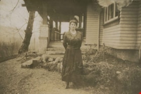
Mam Tabs in front of House of Travers
https://search.heritageburnaby.ca/link/archivedescription39140
- Repository
- City of Burnaby Archives
- Date
- 1921
- Collection/Fonds
- Peers Family and Hill Family fonds
- Description Level
- Item
- Physical Description
- 1 photograph : b&w ; 5.5 x 8 cm on page 24.5 x 32.5 cm (pasted in album)
- Scope and Content
- Photograph of Alice Travers (also know as "Mam Tabs") standing outside the Travers family home on Stanley Street.
- Repository
- City of Burnaby Archives
- Date
- 1921
- Collection/Fonds
- Peers Family and Hill Family fonds
- Physical Description
- 1 photograph : b&w ; 5.5 x 8 cm on page 24.5 x 32.5 cm (pasted in album)
- Description Level
- Item
- Record No.
- 477-459
- Access Restriction
- No restrictions
- Reproduction Restriction
- No known restrictions
- Accession Number
- 2007-12
- Scope and Content
- Photograph of Alice Travers (also know as "Mam Tabs") standing outside the Travers family home on Stanley Street.
- Names
- Travers, Alice
- Media Type
- Photograph
- Notes
- Title based on caption accompanying photograph
- Geographic Access
- Stanley Street
- Street Address
- 7828 Stanley Street
- Historic Neighbourhood
- Burnaby Lake (Historic Neighbourhood)
- Planning Study Area
- Lakeview-Mayfield Area
Images
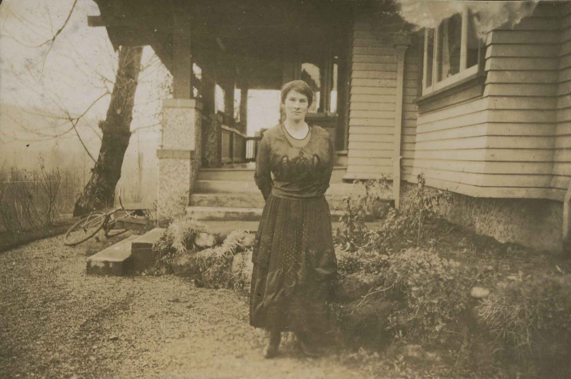

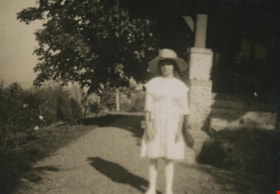
Alice Travers with her children
https://search.heritageburnaby.ca/link/archivedescription39141
- Repository
- City of Burnaby Archives
- Date
- 1921
- Collection/Fonds
- Peers Family and Hill Family fonds
- Description Level
- Item
- Physical Description
- 1 photograph : b&w ; 5 x 8.5 cm on page 24.5 x 32.5 cm (pasted in album)
- Scope and Content
- Photograph of Alice Travers with her two children. The boy is identified as Robbie and the daughter is Maude.
- Repository
- City of Burnaby Archives
- Date
- 1921
- Collection/Fonds
- Peers Family and Hill Family fonds
- Physical Description
- 1 photograph : b&w ; 5 x 8.5 cm on page 24.5 x 32.5 cm (pasted in album)
- Description Level
- Item
- Record No.
- 477-460
- Access Restriction
- No restrictions
- Reproduction Restriction
- No known restrictions
- Accession Number
- 2007-12
- Scope and Content
- Photograph of Alice Travers with her two children. The boy is identified as Robbie and the daughter is Maude.
- Media Type
- Photograph
- Notes
- Title based on caption accompanying photograph
- Geographic Access
- Stanley Street
- Street Address
- 7828 Stanley Street
- Historic Neighbourhood
- Burnaby Lake (Historic Neighbourhood)
- Planning Study Area
- Lakeview-Mayfield Area
Images
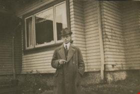
R.D. Travers
https://search.heritageburnaby.ca/link/archivedescription39142
- Repository
- City of Burnaby Archives
- Date
- 1921
- Collection/Fonds
- Peers Family and Hill Family fonds
- Description Level
- Item
- Physical Description
- 1 photograph : b&w ; 5.5 x 8 cm on page 24.5 x 32.5 cm (pasted in album)
- Scope and Content
- Photograph of R.D. Travers outside the Travers family home.
- Repository
- City of Burnaby Archives
- Date
- 1921
- Collection/Fonds
- Peers Family and Hill Family fonds
- Physical Description
- 1 photograph : b&w ; 5.5 x 8 cm on page 24.5 x 32.5 cm (pasted in album)
- Description Level
- Item
- Record No.
- 477-461
- Access Restriction
- No restrictions
- Reproduction Restriction
- No known restrictions
- Accession Number
- 2007-12
- Scope and Content
- Photograph of R.D. Travers outside the Travers family home.
- Names
- Travers, Robert
- Media Type
- Photograph
- Notes
- Title based on caption accompanying photograph
- Geographic Access
- Stanley Street
- Street Address
- 7828 Stanley Street
- Historic Neighbourhood
- Burnaby Lake (Historic Neighbourhood)
- Planning Study Area
- Lakeview-Mayfield Area
Images

Maude Travers
https://search.heritageburnaby.ca/link/archivedescription39143
- Repository
- City of Burnaby Archives
- Date
- 1921
- Collection/Fonds
- Peers Family and Hill Family fonds
- Description Level
- Item
- Physical Description
- 1 photograph : b&w ; 5.5 x 7.8 cm on page 24.5 x 32.5 cm (pasted in album)
- Scope and Content
- Photograph of Maude Travers, the daughter of Alice Travers standing outside the Travers family home.
- Repository
- City of Burnaby Archives
- Date
- 1921
- Collection/Fonds
- Peers Family and Hill Family fonds
- Physical Description
- 1 photograph : b&w ; 5.5 x 7.8 cm on page 24.5 x 32.5 cm (pasted in album)
- Description Level
- Item
- Record No.
- 477-462
- Access Restriction
- No restrictions
- Reproduction Restriction
- No known restrictions
- Accession Number
- 2007-12
- Scope and Content
- Photograph of Maude Travers, the daughter of Alice Travers standing outside the Travers family home.
- Names
- Travers, Maude
- Media Type
- Photograph
- Notes
- Title based on caption accompanying photograph
- Geographic Access
- Stanley Street
- Street Address
- 7828 Stanley Street
- Historic Neighbourhood
- Burnaby Lake (Historic Neighbourhood)
- Planning Study Area
- Lakeview-Mayfield Area
Images

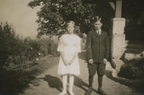
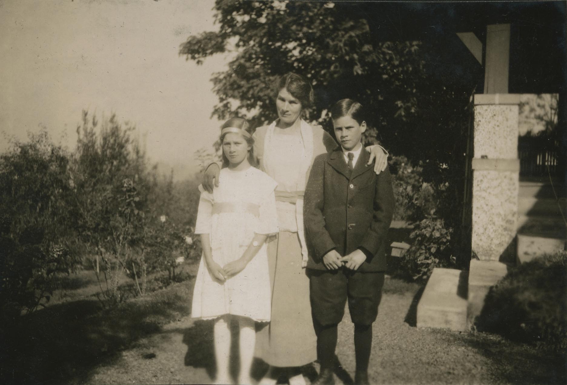
Robbie and Maude Travers
https://search.heritageburnaby.ca/link/archivedescription39144
- Repository
- City of Burnaby Archives
- Date
- 1921
- Collection/Fonds
- Peers Family and Hill Family fonds
- Description Level
- Item
- Physical Description
- 1 photograph : b&w ; 5.5 x 8 cm on page 24.5 x 32.5 cm (pasted in album)
- Scope and Content
- Photograph of the Travers children, Robbie and his sister, Maude. The photograph was taken outside the Travers home.
- Repository
- City of Burnaby Archives
- Date
- 1921
- Collection/Fonds
- Peers Family and Hill Family fonds
- Physical Description
- 1 photograph : b&w ; 5.5 x 8 cm on page 24.5 x 32.5 cm (pasted in album)
- Description Level
- Item
- Record No.
- 477-463
- Access Restriction
- No restrictions
- Reproduction Restriction
- No known restrictions
- Accession Number
- 2007-12
- Scope and Content
- Photograph of the Travers children, Robbie and his sister, Maude. The photograph was taken outside the Travers home.
- Media Type
- Photograph
- Notes
- Title based on caption accompanying photograph
- Geographic Access
- Stanley Street
- Street Address
- 7828 Stanley Street
- Historic Neighbourhood
- Burnaby Lake (Historic Neighbourhood)
- Planning Study Area
- Lakeview-Mayfield Area
Images


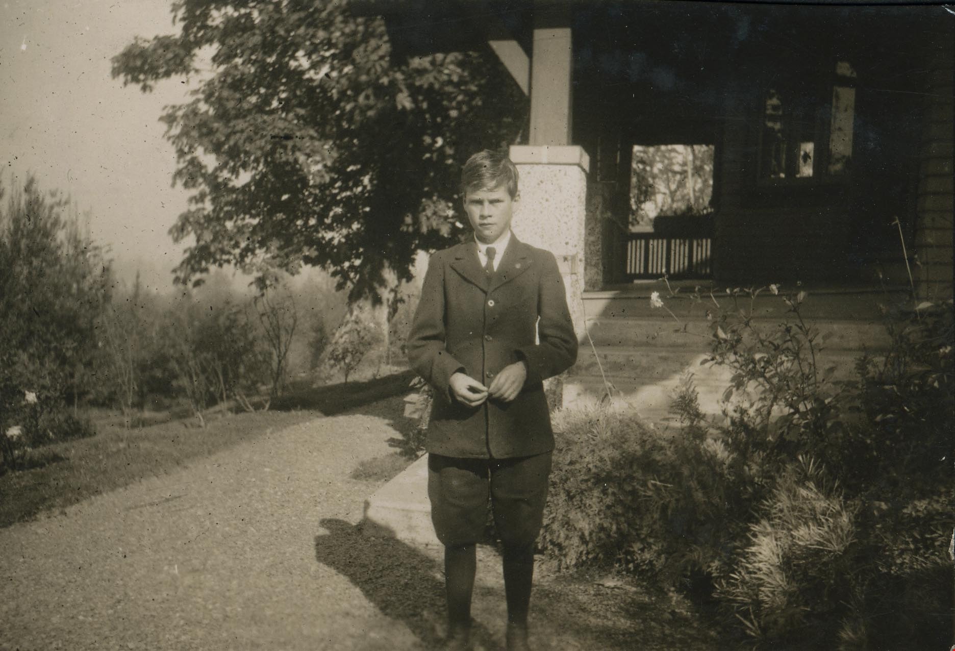
Robbie Travers
https://search.heritageburnaby.ca/link/archivedescription39145
- Repository
- City of Burnaby Archives
- Date
- 1921
- Collection/Fonds
- Peers Family and Hill Family fonds
- Description Level
- Item
- Physical Description
- 1 photograph : b&w ; 5.5 x 8 cm on page 24.5 x 32.5 cm (pasted in album)
- Scope and Content
- Photograph of Robbie Travers outside the Travers family home.
- Repository
- City of Burnaby Archives
- Date
- 1921
- Collection/Fonds
- Peers Family and Hill Family fonds
- Physical Description
- 1 photograph : b&w ; 5.5 x 8 cm on page 24.5 x 32.5 cm (pasted in album)
- Description Level
- Item
- Record No.
- 477-464
- Access Restriction
- No restrictions
- Reproduction Restriction
- No known restrictions
- Accession Number
- 2007-12
- Scope and Content
- Photograph of Robbie Travers outside the Travers family home.
- Names
- Travers, Robbie
- Media Type
- Photograph
- Notes
- Title based on caption accompanying photograph
- Geographic Access
- Stanley Street
- Street Address
- 7828 Stanley Street
- Historic Neighbourhood
- Burnaby Lake (Historic Neighbourhood)
- Planning Study Area
- Lakeview-Mayfield Area
Images
![The Lions from Burnaby Park, [between 1926 and 1929] thumbnail](/media/hpo/_Data/_BVM_Images/1971/197202040003.jpg?width=280)
The Lions from Burnaby Park
https://search.heritageburnaby.ca/link/museumdescription3109
- Repository
- Burnaby Village Museum
- Date
- [between 1926 and 1929]
- Collection/Fonds
- Burnaby Village Museum Photograph collection
- Description Level
- Item
- Physical Description
- 1 photograph : b&w photogravure ; 14.5 x 9.5 cm
- Scope and Content
- Photograph of the north shore mountains, including the Lions, taken from Robert Burnaby Park.
- Repository
- Burnaby Village Museum
- Collection/Fonds
- Burnaby Village Museum Photograph collection
- Description Level
- Item
- Physical Description
- 1 photograph : b&w photogravure ; 14.5 x 9.5 cm
- Scope and Content
- Photograph of the north shore mountains, including the Lions, taken from Robert Burnaby Park.
- Geographic Access
- Wedgewood Street
- Robert Burnaby Park
- Street Address
- 8155 Wedgewood Street
- Accession Code
- HV972.204.3
- Access Restriction
- No restrictions
- Reproduction Restriction
- No known restrictions
- Date
- [between 1926 and 1929]
- Media Type
- Photograph
- Historic Neighbourhood
- Burnaby Lake (Historic Neighbourhood)
- Planning Study Area
- Lakeview-Mayfield Area
- Related Material
- For other photographs from the same album, see HV972.204.3 - .14
- Scan Resolution
- 600
- Scan Date
- 2023-04-25
- Photographer
- Lloyd, Frank Ernest
- Notes
- Annotations made in white paint on recto of photograph read: "'The Lions' from Burnaby Park" and "Lloyd Studio, McKay."
Images
![The Lions from Burnaby Park, [between 1926 and 1929] thumbnail](/media/hpo/_Data/_BVM_Images/1971/197202040003.jpg)
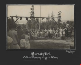
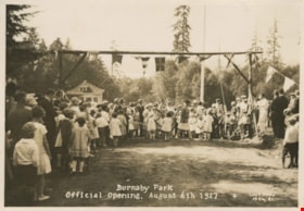
Opening of Burnaby Park
https://search.heritageburnaby.ca/link/archivedescription34576
- Repository
- City of Burnaby Archives
- Date
- August 6, 1927
- Collection/Fonds
- Burnaby Historical Society fonds
- Description Level
- Item
- Physical Description
- 1 photograph : b&w ; 15.8 x 24.2 cm mounted on 29.1 x 38.7 cm cardboard
- Scope and Content
- Photograph of the official opening of Burnaby Park at the foot of 2nd Street. A crowd is gathered under an arch decorated with flags, and a ribbon is stretched across the arch.
- Repository
- City of Burnaby Archives
- Date
- August 6, 1927
- Collection/Fonds
- Burnaby Historical Society fonds
- Subseries
- Photographs subseries
- Physical Description
- 1 photograph : b&w ; 15.8 x 24.2 cm mounted on 29.1 x 38.7 cm cardboard
- Description Level
- Item
- Record No.
- 055-001
- Access Restriction
- No restrictions
- Reproduction Restriction
- No known restrictions
- Accession Number
- BHS2007-04
- Scope and Content
- Photograph of the official opening of Burnaby Park at the foot of 2nd Street. A crowd is gathered under an arch decorated with flags, and a ribbon is stretched across the arch.
- Media Type
- Photograph
- Photographer
- Lloyd's Studio
- Notes
- Title based on contents of photograph
- Annotation on bottom front of cardboard reads, "Burnaby Park / Official Opening, August 6th, 1927"
- Geographic Access
- Robert Burnaby Park
- Wedgewood Street
- Street Address
- 8155 Wedgewood Street
- Historic Neighbourhood
- Burnaby Lake (Historic Neighbourhood)
- Planning Study Area
- Lakeview-Mayfield Area
Images


Burnaby Park
https://search.heritageburnaby.ca/link/archivedescription34577
- Repository
- City of Burnaby Archives
- Date
- 1927
- Collection/Fonds
- Burnaby Historical Society fonds
- Description Level
- Item
- Physical Description
- 1 photograph : b&w ; 34.5 x 23.3 cm mounted on 49.5 x 35.1 cm cardboard
- Scope and Content
- Photograph taken from Burnaby Park, including trees and mountains in the distance.
- Repository
- City of Burnaby Archives
- Date
- 1927
- Collection/Fonds
- Burnaby Historical Society fonds
- Subseries
- Photographs subseries
- Physical Description
- 1 photograph : b&w ; 34.5 x 23.3 cm mounted on 49.5 x 35.1 cm cardboard
- Description Level
- Item
- Record No.
- 055-002
- Access Restriction
- No restrictions
- Reproduction Restriction
- No known restrictions
- Accession Number
- BHS2007-04
- Scope and Content
- Photograph taken from Burnaby Park, including trees and mountains in the distance.
- Media Type
- Photograph
- Photographer
- Lloyd's Studio
- Notes
- Title based on contents of photograph
- Annotation on bottom front of cardboard reads, "Burnaby Park / Officially Opened August 6th, 1927"
- Geographic Access
- Robert Burnaby Park
- Wedgewood Street
- Street Address
- 8155 Wedgewood Street
- Historic Neighbourhood
- Burnaby Lake (Historic Neighbourhood)
- Planning Study Area
- Lakeview-Mayfield Area
Images

Opening of Burnaby Park
https://search.heritageburnaby.ca/link/archivedescription34257
- Repository
- City of Burnaby Archives
- Date
- August 6, 1927
- Collection/Fonds
- Burnaby Historical Society fonds
- Description Level
- Item
- Physical Description
- 1 photograph : b&w ; 11.7 x 16.7 cm
- Scope and Content
- Photograph of the opening of Burnaby Park at the foot of 2nd Street. The photograph was likely taken just after the ribbon cutting.
- Repository
- City of Burnaby Archives
- Date
- August 6, 1927
- Collection/Fonds
- Burnaby Historical Society fonds
- Subseries
- George Jeffery subseries
- Physical Description
- 1 photograph : b&w ; 11.7 x 16.7 cm
- Description Level
- Item
- Record No.
- 013-001
- Access Restriction
- No restrictions
- Reproduction Restriction
- No known restrictions
- Accession Number
- BHS2007-04
- Scope and Content
- Photograph of the opening of Burnaby Park at the foot of 2nd Street. The photograph was likely taken just after the ribbon cutting.
- Media Type
- Photograph
- Photographer
- Lloyd's Studio
- Notes
- Title based on caption of photograph
- Annotation at bottom of photograph reads, "Burnaby Park / Official Opening, August 6th 1927"
- Geographic Access
- Wedgewood Street
- Robert Burnaby Park
- Street Address
- 8155 Wedgewood Street
- Historic Neighbourhood
- Burnaby Lake (Historic Neighbourhood)
- Planning Study Area
- Lakeview-Mayfield Area
Images

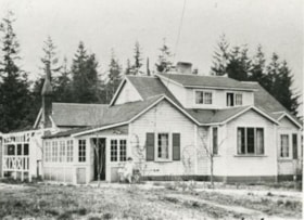
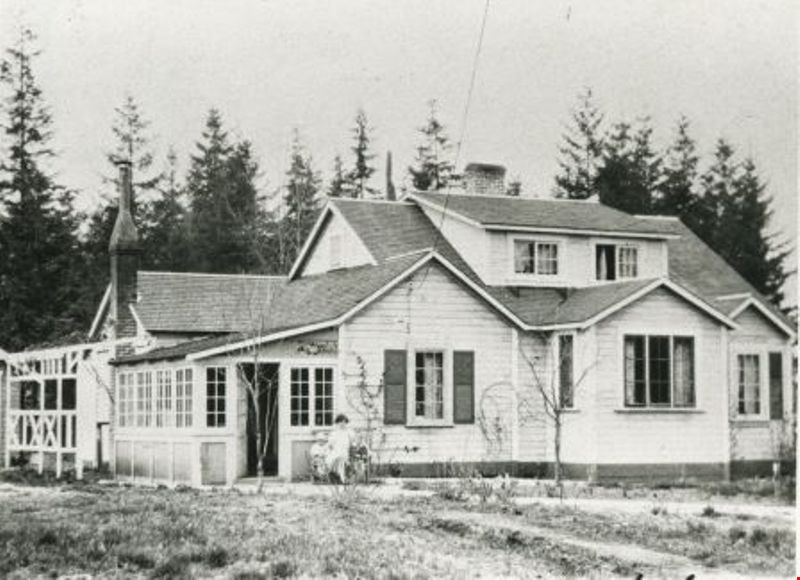
Hawkshaw family home
https://search.heritageburnaby.ca/link/archivedescription35164
- Repository
- City of Burnaby Archives
- Date
- 1927 (date of original), copied 1986
- Collection/Fonds
- Burnaby Historical Society fonds
- Description Level
- Item
- Physical Description
- 1 photograph : b&w ; 12.7 x 17.8 cm print
- Scope and Content
- Photograph of the Hawkshaw family home, 763 Wedgewood Street (later renumbered 7743 Wedgewood Street), East Burnaby. The Hawkshaw family lived here between 1920 and 1929. Mabel Hawkshaw and her son, Cedric, are outside.
- Repository
- City of Burnaby Archives
- Date
- 1927 (date of original), copied 1986
- Collection/Fonds
- Burnaby Historical Society fonds
- Subseries
- Pioneer Tales subseries
- Physical Description
- 1 photograph : b&w ; 12.7 x 17.8 cm print
- Description Level
- Item
- Record No.
- 204-021
- Access Restriction
- No restrictions
- Reproduction Restriction
- No known restrictions
- Accession Number
- BHS1988-03
- Scope and Content
- Photograph of the Hawkshaw family home, 763 Wedgewood Street (later renumbered 7743 Wedgewood Street), East Burnaby. The Hawkshaw family lived here between 1920 and 1929. Mabel Hawkshaw and her son, Cedric, are outside.
- Subjects
- Buildings - Residential - Houses
- Media Type
- Photograph
- Notes
- Title based on contents of photograph
- Geographic Access
- Wedgewood Street
- Street Address
- 7743 Wedgewood Street
- Historic Neighbourhood
- East Burnaby (Historic Neighbourhood)
- Planning Study Area
- Lakeview-Mayfield Area
Images
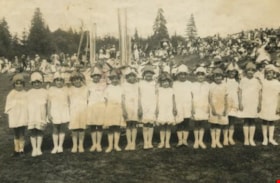
Kingsway West Maypole dancers
https://search.heritageburnaby.ca/link/archivedescription36034
- Repository
- City of Burnaby Archives
- Date
- May 1927
- Collection/Fonds
- Burnaby Historical Society fonds
- Description Level
- Item
- Physical Description
- 1 photograph : sepia ; 11 x 16 cm mounted on heavyweight drawing paper
- Scope and Content
- Photograph of the Kingsway West Maypole Dancers standing in a row with the Maypoles behind them on May Day, at Robert Burnaby Park.
- Repository
- City of Burnaby Archives
- Date
- May 1927
- Collection/Fonds
- Burnaby Historical Society fonds
- Subseries
- B. Keisler subseries
- Physical Description
- 1 photograph : sepia ; 11 x 16 cm mounted on heavyweight drawing paper
- Description Level
- Item
- Record No.
- 214-004
- Access Restriction
- No restrictions
- Reproduction Restriction
- No known restrictions
- Accession Number
- BHS1988-15
- Scope and Content
- Photograph of the Kingsway West Maypole Dancers standing in a row with the Maypoles behind them on May Day, at Robert Burnaby Park.
- Subjects
- Events - May Day
- Clothing
- Names
- Kingsway West School
- Media Type
- Photograph
- Notes
- Title based on contents of photograph
- Geographic Access
- Robert Burnaby Park
- Wedgewood Street
- Street Address
- 8155 Wedgewood Street
- Historic Neighbourhood
- Burnaby Lake (Historic Neighbourhood)
- Planning Study Area
- Lakeview-Mayfield Area
Images
