![Burnaby creek conservationists, [2002] thumbnail](/media/hpo/_Data/_Archives_Images/_Unrestricted/535/535-1959-1.jpg?width=280)
Burnaby creek conservationists
https://search.heritageburnaby.ca/link/archivedescription96276
- Repository
- City of Burnaby Archives
- Date
- [2002]
- Collection/Fonds
- Burnaby NewsLeader photograph collection
- Description Level
- File
- Physical Description
- 4 photographs (tiff) : col.
- Scope and Content
- File contains photographs of volunteer conservationists with the Eagle Creek Streamkeepers, Byrne Creek Streamkeepers, and Sapperton Fish & Game Club at work in the Lake City area by Eagle Creek and the Brunette River. Photographs depict Nick Kvenich, of the Eagle Creek Streamkeepers, in a creek; m…
- Repository
- City of Burnaby Archives
- Date
- [2002]
- Collection/Fonds
- Burnaby NewsLeader photograph collection
- Physical Description
- 4 photographs (tiff) : col.
- Description Level
- File
- Record No.
- 535-1959
- Access Restriction
- No restrictions
- Reproduction Restriction
- No restrictions
- Accession Number
- 2018-12
- Scope and Content
- File contains photographs of volunteer conservationists with the Eagle Creek Streamkeepers, Byrne Creek Streamkeepers, and Sapperton Fish & Game Club at work in the Lake City area by Eagle Creek and the Brunette River. Photographs depict Nick Kvenich, of the Eagle Creek Streamkeepers, in a creek; members of the Byrne Creek Streamkeepers observing a storm drain; and Elmer Rudolf feeding fish at a Sapperton Fish & Game Club hatchery.
- Subjects
- Geographic Features - Creeks
- Geographic Features - Lakes and Ponds
- Geographic Features - Ravines
- Geographic Features - Streams
- Media Type
- Photograph
- Photographer
- Bartel, Mario
- Notes
- Title based on caption
- Collected by editorial for use in a March 2002 issue of the Burnaby NewsLeader
- Caption from metadata for 535-1959-1: "Nick Kvenich is one of the founding members of the Eagle Creek Streamkeepers, which is looking to preserve the habitat of the creek that runs down from Squint Lake into a ravine below the Lake City industrial area."
- Caption from metadata for 535-1959-2: "Joan Carne (r) and Louise Towell, of the Byrne Creek Streamkeepers, examine a storm drain in an industrial area above the creek. The habitat faces constant pressure from businesses and homeowners who pour solvents, soaps and substances into the drains without thought to the consequences."
- Caption from metadata for 535-1959-3: "Nick Kvenich, one of the founding members of the Eagle Creek Streamkeepers, climbs through a fallen tree that is blocking a trail that runs alongside the creek, in a ravine below the Lake City industrial area. Although the tree will eventually be cleared by the GVRD, Kvenich says he prefers if such obstacles be left alone, as they would discourage people who might abuse the habitat."
- Caption from metadata for 535-1959-4: "Elmer Rudolf feeds a new batch of coho fry at the Sapperton Fish & Game Club's hatchery, near the Brunette River. The fry are normally fed by a timed conveyor belt, but that is supplemented by hand feedings to give the weaker fish a chance."
- Geographic Access
- Brunette River
- Eagle Creek
- Planning Study Area
- Lake City Area
Images
![Burnaby creek conservationists, [2002] thumbnail](/media/hpo/_Data/_Archives_Images/_Unrestricted/535/535-1959-1.jpg)

Across the inlet from Barnet
https://search.heritageburnaby.ca/link/museumdescription15222
- Repository
- Burnaby Village Museum
- Date
- July 1934 (date of original), copied 2004
- Collection/Fonds
- In the Shadow by the Sea collection
- Description Level
- Item
- Physical Description
- 1 photograph (tiff) : 300 dpi
- Scope and Content
- Photograph looking across Burrard Inlet from the Village of Barnet. The rugged coastline of the north shore of the inlet is visible with rock formations and forest.
- Repository
- Burnaby Village Museum
- Collection/Fonds
- In the Shadow by the Sea collection
- Description Level
- Item
- Physical Description
- 1 photograph (tiff) : 300 dpi
- Material Details
- Original photograph appears to be hand coloured
- Scope and Content
- Photograph looking across Burrard Inlet from the Village of Barnet. The rugged coastline of the north shore of the inlet is visible with rock formations and forest.
- Subjects
- Geographic Features - Inlets
- Geographic Features - Rock Formations
- Geographic Features - Forests
- Geographic Access
- Burrard Inlet
- Accession Code
- BV019.32.42
- Access Restriction
- No restrictions
- Reproduction Restriction
- No known restrictions
- Date
- July 1934 (date of original), copied 2004
- Media Type
- Photograph
- Historic Neighbourhood
- Barnet (Historic Neighbourhood)
- Planning Study Area
- Burnaby Mountain Area
- Notes
- Title based on contents of photograph
Images


Boat coming through locks
https://search.heritageburnaby.ca/link/museumdescription19435
- Repository
- Burnaby Village Museum
- Date
- 11 Oct. 1936
- Collection/Fonds
- Hawkshaw family fonds
- Description Level
- Item
- Physical Description
- 1 photograph : sepia ; 6.5 x 9 cm
- Scope and Content
- Photograph of a boat towing a log boom and coming through the Hiram M. Chittenden Locks (Ballard Locks) in Salmon Bay in Seattle, Washington's Ship Canal. The locks link Lake Washington to Puget Sound. The Salmon Bay Bridge is visible in the background spanning Salmon Bay.
- Repository
- Burnaby Village Museum
- Collection/Fonds
- Hawkshaw family fonds
- Description Level
- Item
- Physical Description
- 1 photograph : sepia ; 6.5 x 9 cm
- Scope and Content
- Photograph of a boat towing a log boom and coming through the Hiram M. Chittenden Locks (Ballard Locks) in Salmon Bay in Seattle, Washington's Ship Canal. The locks link Lake Washington to Puget Sound. The Salmon Bay Bridge is visible in the background spanning Salmon Bay.
- Subjects
- Transportation - Boats
- Geographic Features - Natural Waterways
- Geographic Features - Channels
- Geographic Features - Bays
- Structures - Bridges
- Water Control
- Accession Code
- BV996.6.119
- Access Restriction
- No restrictions
- Reproduction Restriction
- No known restrictions
- Date
- 11 Oct. 1936
- Media Type
- Photograph
- Scan Resolution
- 600
- Scan Date
- 2023-02-06
- Notes
- Title based on contents of photograph
- Caption beneath photograph reads: "COMING IN"
- Caption of album page reads: "Oct 11/36 / THANKSGIVING / SEATTLE"
- Photograph is part of photograph album BV996.6.1
Images

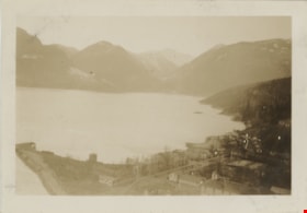
Britannia Beach at dark
https://search.heritageburnaby.ca/link/museumdescription19558
- Repository
- Burnaby Village Museum
- Date
- 1939
- Collection/Fonds
- Hawkshaw family fonds
- Description Level
- Item
- Physical Description
- 1 photograph : b&w ; 6.5 x 9 cm
- Scope and Content
- Photograph of Britannia Beach looking towards Howe Sound at dark.
- Repository
- Burnaby Village Museum
- Collection/Fonds
- Hawkshaw family fonds
- Description Level
- Item
- Physical Description
- 1 photograph : b&w ; 6.5 x 9 cm
- Scope and Content
- Photograph of Britannia Beach looking towards Howe Sound at dark.
- Subjects
- Geographic Features - Natural Geographic Features
- Geographic Features - Mountains
- Industries - Mining
- Accession Code
- BV996.6.265
- Access Restriction
- No restrictions
- Reproduction Restriction
- No known restrictions
- Date
- 1939
- Media Type
- Photograph
- Scan Date
- 2023-02-16
- Notes
- Title based on contents of photograph
- Caption beneath photograph reads: "At Dark"
- Caption on page of photograph album reads: "Spring / of / 1939"
- Photograph is part of photograph album BV996.6.1
Images

![Burnaby Mountain, [between 1958 and 1965] (date of original), copied 1991 thumbnail](/media/hpo/_Data/_Archives_Images/_Unrestricted/370/370-797.jpg?width=280)
Burnaby Mountain
https://search.heritageburnaby.ca/link/archivedescription38210
- Repository
- City of Burnaby Archives
- Date
- [between 1958 and 1965] (date of original), copied 1991
- Collection/Fonds
- Burnaby Historical Society fonds
- Description Level
- Item
- Physical Description
- 1 photograph : b&w ; 3.2 x 5.1 cm print on contact sheet 20.5 x 26.8 cm
- Scope and Content
- Aerial photograph of Centennial Park, Burnaby Mountain and Burrard Inlet looking east.
- Repository
- City of Burnaby Archives
- Date
- [between 1958 and 1965] (date of original), copied 1991
- Collection/Fonds
- Burnaby Historical Society fonds
- Subseries
- Burnaby Image Bank subseries
- Physical Description
- 1 photograph : b&w ; 3.2 x 5.1 cm print on contact sheet 20.5 x 26.8 cm
- Description Level
- Item
- Record No.
- 370-797
- Access Restriction
- No restrictions
- Reproduction Restriction
- May be restricted by third party rights
- Accession Number
- BHS1999-03
- Scope and Content
- Aerial photograph of Centennial Park, Burnaby Mountain and Burrard Inlet looking east.
- Subjects
- Aerial Photographs
- Geographic Features - Inlets
- Geographic Features - Mountains
- Geographic Features - Parks
- Media Type
- Photograph
- Notes
- Title based on contents of photograph
- 1 b&w copy negative accompanying
- Geographic Access
- Burnaby Mountain Conservation Area
- Planning Study Area
- Burnaby Mountain Area
Images
![Burnaby Mountain, [between 1958 and 1965] (date of original), copied 1991 thumbnail](/media/hpo/_Data/_Archives_Images/_Unrestricted/370/370-797.jpg)

Burnaby Mountain Park
https://search.heritageburnaby.ca/link/archivedescription93639
- Repository
- City of Burnaby Archives
- Date
- November 19, 1977
- Collection/Fonds
- Burnaby Public Library Contemporary Visual Archive Project
- Description Level
- Item
- Physical Description
- 1 photograph : b&w ; 12.5 x 17.5 cm
- Scope and Content
- Photograph of the hillside on the top of Burnaby Mountain Park, with a person in the foreground looking out to the view. The photograph is taken facing northwest and shows the view over the the Burrard Inlet. Capitol Hill, the North Shore Mountains, and downtown Vancouver are visible in the distanc…
- Repository
- City of Burnaby Archives
- Date
- November 19, 1977
- Collection/Fonds
- Burnaby Public Library Contemporary Visual Archive Project
- Physical Description
- 1 photograph : b&w ; 12.5 x 17.5 cm
- Description Level
- Item
- Record No.
- 556-596
- Access Restriction
- No restrictions
- Reproduction Restriction
- Reproduce for fair dealing purposes only
- Accession Number
- 2017-57
- Scope and Content
- Photograph of the hillside on the top of Burnaby Mountain Park, with a person in the foreground looking out to the view. The photograph is taken facing northwest and shows the view over the the Burrard Inlet. Capitol Hill, the North Shore Mountains, and downtown Vancouver are visible in the distance.
- Names
- Burnaby Mountain Park
- Media Type
- Photograph
- Photographer
- van Mannen, Mark
- Notes
- Title taken from project information form
- Accompanied by a project information form and 1 photograph (b&w negative ; 9.5 x 12.5 cm)
- BPL no. 45
- Geographic Access
- Burnaby Mountain Conservation Area
- Planning Study Area
- Burnaby Mountain Area
Images


Burnaby Mountain Park
https://search.heritageburnaby.ca/link/archivedescription93640
- Repository
- City of Burnaby Archives
- Date
- November 19, 1977
- Collection/Fonds
- Burnaby Public Library Contemporary Visual Archive Project
- Description Level
- Item
- Physical Description
- 1 photograph : b&w ; 12.5 x 17.5 cm
- Scope and Content
- Photograph of the top of Burnaby Mountain Park and the view of Vancouver from the hillside, with a man standing in the foreground. The photograph is taken facing west of southwest. Capitol Hill, the Burrard Inlet, the North Shore Mountains, Vancouver, and Stanley Park are visible in the distance.
- Repository
- City of Burnaby Archives
- Date
- November 19, 1977
- Collection/Fonds
- Burnaby Public Library Contemporary Visual Archive Project
- Physical Description
- 1 photograph : b&w ; 12.5 x 17.5 cm
- Description Level
- Item
- Record No.
- 556-597
- Access Restriction
- No restrictions
- Reproduction Restriction
- Reproduce for fair dealing purposes only
- Accession Number
- 2017-57
- Scope and Content
- Photograph of the top of Burnaby Mountain Park and the view of Vancouver from the hillside, with a man standing in the foreground. The photograph is taken facing west of southwest. Capitol Hill, the Burrard Inlet, the North Shore Mountains, Vancouver, and Stanley Park are visible in the distance.
- Names
- Burnaby Mountain Park
- Media Type
- Photograph
- Photographer
- McGillivray, Don
- Notes
- Title taken from project information form
- Accompanied by a project information form and 1 photograph (b&w negative ; 9.5 x 12.5 cm)
- BPL no. 46
- Geographic Access
- Burnaby Mountain Conservation Area
- Planning Study Area
- Burnaby Mountain Area
Images


Burnaby Mountain Park
https://search.heritageburnaby.ca/link/archivedescription93645
- Repository
- City of Burnaby Archives
- Date
- November 19, 1977
- Collection/Fonds
- Burnaby Public Library Contemporary Visual Archive Project
- Description Level
- Item
- Physical Description
- 1 photograph : b&w ; 12.5 x 17.5 cm
- Scope and Content
- Photograph of the view from Burnaby Mountain of the Burrard Inlet, the oil refinery, and the mountains. The photograph is taken from Burnaby Mountain Park, facing north.
- Repository
- City of Burnaby Archives
- Date
- November 19, 1977
- Collection/Fonds
- Burnaby Public Library Contemporary Visual Archive Project
- Physical Description
- 1 photograph : b&w ; 12.5 x 17.5 cm
- Description Level
- Item
- Record No.
- 556-602
- Access Restriction
- No restrictions
- Reproduction Restriction
- Reproduce for fair dealing purposes only
- Accession Number
- 2017-57
- Scope and Content
- Photograph of the view from Burnaby Mountain of the Burrard Inlet, the oil refinery, and the mountains. The photograph is taken from Burnaby Mountain Park, facing north.
- Subjects
- Geographic Features - Inlets
- Geographic Features - Parks
- Geographic Features - Mountains
- Buildings - Industrial - Refineries
- Names
- Burnaby Mountain Park
- Media Type
- Photograph
- Photographer
- van Mannen, Mark
- Notes
- Title taken from project information form
- Accompanied by a project information form and 1 photograph (b&w negative ; 9.5 x 12.5 cm)
- BPL no. 52
- Geographic Access
- Burnaby Mountain Conservation Area
- Burrard Inlet
- Planning Study Area
- Burnaby Mountain Area
Images


Burnaby Mountain Park Looking West
https://search.heritageburnaby.ca/link/archivedescription93707
- Repository
- City of Burnaby Archives
- Date
- February 15, 1978
- Collection/Fonds
- Burnaby Public Library Contemporary Visual Archive Project
- Description Level
- Item
- Physical Description
- 1 photograph : b&w ; 12.5 x 17.5 cm
- Scope and Content
- Photograph of the view from Burnaby Mountain Park. The photograph is taken facing west and shows the park, part of the parking lot at the Burnaby Centennial Pavilion, and Capitol Hill and the mountains in the distance.
- Repository
- City of Burnaby Archives
- Date
- February 15, 1978
- Collection/Fonds
- Burnaby Public Library Contemporary Visual Archive Project
- Physical Description
- 1 photograph : b&w ; 12.5 x 17.5 cm
- Description Level
- Item
- Record No.
- 556-664
- Access Restriction
- No restrictions
- Reproduction Restriction
- Reproduce for fair dealing purposes only
- Accession Number
- 2017-57
- Scope and Content
- Photograph of the view from Burnaby Mountain Park. The photograph is taken facing west and shows the park, part of the parking lot at the Burnaby Centennial Pavilion, and Capitol Hill and the mountains in the distance.
- Subjects
- Geographic Features - Parks
- Geographic Features - Mountains
- Geographic Features - Automobile Parking Lots
- Names
- Burnaby Mountain Park
- Media Type
- Photograph
- Photographer
- Surridge, Jack
- Notes
- Title taken from project information form
- Accompanied by a project information form and 1 photograph (b&w negative ; 9.5 x 12.5 cm)
- BPL no. 112
- Geographic Access
- Burnaby Mountain Conservation Area
- Street Address
- 100 Centennial Way
- Planning Study Area
- Burnaby Mountain Area
Images

![Burnaby rivers, [2002] thumbnail](/media/hpo/_Data/_Archives_Images/_Unrestricted/535/535-2800-1.jpg?width=280)
Burnaby rivers
https://search.heritageburnaby.ca/link/archivedescription97440
- Repository
- City of Burnaby Archives
- Date
- [2002]
- Collection/Fonds
- Burnaby NewsLeader photograph collection
- Description Level
- File
- Physical Description
- 4 photographs (tiff) : col.
- Scope and Content
- File contains photographs of people with Burnaby rivers and creeks. Photographs depict BCIT river conservationist Mark Angelo posing in Deer Lake Brook by Burnaby Village Museum, and Lorna Johnson, Gordie Cook, and Jack McAfee enjoying Fraser Foreshore Park by the Fraser River.
- Repository
- City of Burnaby Archives
- Date
- [2002]
- Collection/Fonds
- Burnaby NewsLeader photograph collection
- Physical Description
- 4 photographs (tiff) : col.
- Description Level
- File
- Record No.
- 535-2800
- Access Restriction
- No restrictions
- Reproduction Restriction
- No restrictions
- Accession Number
- 2018-12
- Scope and Content
- File contains photographs of people with Burnaby rivers and creeks. Photographs depict BCIT river conservationist Mark Angelo posing in Deer Lake Brook by Burnaby Village Museum, and Lorna Johnson, Gordie Cook, and Jack McAfee enjoying Fraser Foreshore Park by the Fraser River.
- Media Type
- Photograph
- Photographer
- Bartel, Mario
- Notes
- Title based on caption
- Collected by editorial for use in a September 2002 issue of the Burnaby NewsLeader
- Caption from metadata for 535-2800-1 and 535-2800-2: "Mark Angelo, of BCIT, who's made it his mission to save and preserve Burnaby's rivers and creeks, says he's particularly proud of Deer Lake Brook, as it babbles through Burnaby Village Museum, on its way to Burnaby Lake."
- Caption from metadata for 535-2800-3: "Lorna Johnson hits a tennis ball out into the Fraser River at Fraser Foreshore Park, to her dog, Keiko."
- Caption from metadata for 535-2800-4: "Gordie Cook and Jack McAfee shoot the breeze and enjoy the sunshine along the Fraser River, at Fraser Foreshore Park in Burnaby."
- Geographic Access
- Deer Lake Brook
- Burnaby Fraser Foreshore Park
- Fraser River
- Historic Neighbourhood
- Fraser Arm (Historic Neighbourhood)
- Burnaby Lake (Historic Neighbourhood)
- Planning Study Area
- Morley-Buckingham Area
- Big Bend Area
Images
![Burnaby rivers, [2002] thumbnail](/media/hpo/_Data/_Archives_Images/_Unrestricted/535/535-2800-1.jpg)
![Byrne Creek Streamkeepers, [2001] thumbnail](/media/hpo/_Data/_Archives_Images/_Unrestricted/535/535-2194-1.jpg?width=280)
Byrne Creek Streamkeepers
https://search.heritageburnaby.ca/link/archivedescription96572
- Repository
- City of Burnaby Archives
- Date
- [2001]
- Collection/Fonds
- Burnaby NewsLeader photograph collection
- Description Level
- File
- Physical Description
- 2 photographs (tiff) : col.
- Scope and Content
- File contains members of the Byrne Creek Streamkeepers during their work to protect the waterways and salmon in the area. Photographs depict Bob Fuller checking a waterflow measuring gauge and Joan Carne standing in the overflow channel at the salmon rearing ponds below Marine Drive.
- Repository
- City of Burnaby Archives
- Date
- [2001]
- Collection/Fonds
- Burnaby NewsLeader photograph collection
- Physical Description
- 2 photographs (tiff) : col.
- Description Level
- File
- Record No.
- 535-2194
- Access Restriction
- No restrictions
- Reproduction Restriction
- No restrictions
- Accession Number
- 2018-12
- Scope and Content
- File contains members of the Byrne Creek Streamkeepers during their work to protect the waterways and salmon in the area. Photographs depict Bob Fuller checking a waterflow measuring gauge and Joan Carne standing in the overflow channel at the salmon rearing ponds below Marine Drive.
- Subjects
- Persons - Volunteers
- Geographic Features - Creeks
- Geographic Features - Lakes and Ponds
- Geographic Features - Streams
- Media Type
- Photograph
- Photographer
- Bartel, Mario
- Notes
- Title based on caption
- Collected by editorial for use in a March 2001 issue of the Burnaby NewsLeader
- Caption from metadata for 535-2194-1: "Bob Fuller, of the Byrne Creek Streamkeepers, checks the guage that measures the flow of water which is released from the holding pond below Marine Drive to the salmon spawning beds downstream."
- Caption from metadata for 535-2194-2: "Joan Carne of the Byrne Creek Streamkeepers stands in the overflow channel at the salmon rearing ponds below Marine Drive. Although last week's chemical spill into Byrne Creek didn't reach the ponds, Carne says it's a constant battle to educate people to take care of the area's creeks and streams."
- Geographic Access
- Marine Drive
- Byrne Creek
- Planning Study Area
- Stride Hill Area
Images
![Byrne Creek Streamkeepers, [2001] thumbnail](/media/hpo/_Data/_Archives_Images/_Unrestricted/535/535-2194-1.jpg)

Canada geese in the park
https://search.heritageburnaby.ca/link/archivedescription59046
- Repository
- City of Burnaby Archives
- Date
- ca.1983
- Collection/Fonds
- Columbian Newspaper collection
- Description Level
- Item
- Physical Description
- 1 photograph : b&w ; 17.5 x 20 cm
- Scope and Content
- Photograph of a flock of Canada geese on a grassy field in a park.
- Repository
- City of Burnaby Archives
- Date
- ca.1983
- Collection/Fonds
- Columbian Newspaper collection
- Physical Description
- 1 photograph : b&w ; 17.5 x 20 cm
- Description Level
- Item
- Record No.
- 480-1452
- Access Restriction
- No restrictions
- Reproduction Restriction
- May be restricted by third party rights
- Accession Number
- 2009-01
- Scope and Content
- Photograph of a flock of Canada geese on a grassy field in a park.
- Subjects
- Geographic Features - Fields
- Geographic Features - Lakes and Ponds
- Geographic Features - Parks
- Animals - Birds
- Media Type
- Photograph
- Photographer
- Battistoni, Peter
- Notes
- Title based on contents of photograph
- Photographer's stamp on verso
- Note on verso reads: "page 4 / Burnaby / Today / PMT 100%"
Images

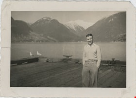
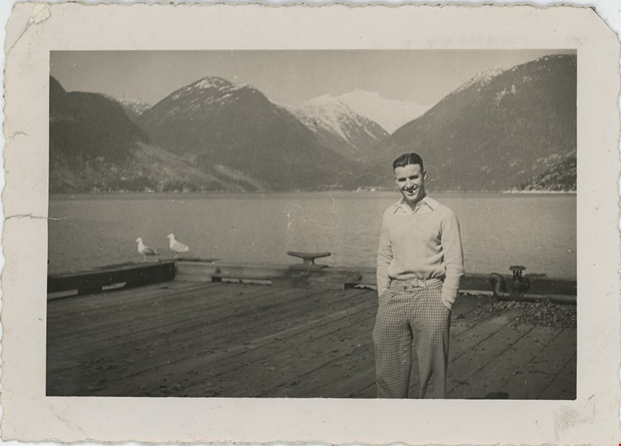
Crichton Hawkshaw standing on dock
https://search.heritageburnaby.ca/link/museumdescription19545
- Repository
- Burnaby Village Museum
- Date
- Apr. 1939
- Collection/Fonds
- Hawkshaw family fonds
- Description Level
- Item
- Physical Description
- 1 photograph : b&w ; 8.5 x 12 cm
- Scope and Content
- Photograph of Crichton Hawkshaw standing on a dock with view of mountains and Howe Sound behind him.
- Repository
- Burnaby Village Museum
- Collection/Fonds
- Hawkshaw family fonds
- Description Level
- Item
- Physical Description
- 1 photograph : b&w ; 8.5 x 12 cm
- Scope and Content
- Photograph of Crichton Hawkshaw standing on a dock with view of mountains and Howe Sound behind him.
- Subjects
- Geographic Features - Mountains
- Geographic Features - Natural Geographic Features
- Structures - Piers and Wharfs
- Accession Code
- BV996.6.252
- Access Restriction
- No restrictions
- Reproduction Restriction
- No known restrictions
- Date
- Apr. 1939
- Media Type
- Photograph
- Scan Date
- 2023-02-16
- Notes
- Title based on contents of photograph
- Caption beneath photograph reads: "April 1939"
- Photograph is part of photograph album BV996.6.1
Images

Deer Lake Gibraltar
https://search.heritageburnaby.ca/link/archivedescription34312
- Repository
- City of Burnaby Archives
- Date
- 1924
- Collection/Fonds
- Burnaby Historical Society fonds
- Description Level
- Item
- Physical Description
- 1 photograph : b&w ; 8.1 x 13.2 cm
- Scope and Content
- Photograph of the "Gibraltar" rock at mouth of Deer Lake Creek. This photograph was taken during the winter of 1924 and the lake is frozen over with ice. The surface of the lake is covered with marks made by ice skates. Deer Lake Creek is historically known as Deer Lake Brook.
- Repository
- City of Burnaby Archives
- Date
- 1924
- Collection/Fonds
- Burnaby Historical Society fonds
- Subseries
- Peers family subseries
- Physical Description
- 1 photograph : b&w ; 8.1 x 13.2 cm
- Description Level
- Item
- Record No.
- 020-019
- Access Restriction
- No restrictions
- Reproduction Restriction
- No known restrictions
- Accession Number
- BHS2007-04
- Scope and Content
- Photograph of the "Gibraltar" rock at mouth of Deer Lake Creek. This photograph was taken during the winter of 1924 and the lake is frozen over with ice. The surface of the lake is covered with marks made by ice skates. Deer Lake Creek is historically known as Deer Lake Brook.
- Subjects
- Geographic Features - Creeks
- Geographic Features - Lakes and Ponds
- Geographic Features - Rock Formations
- Media Type
- Photograph
- Notes
- Title based on caption accompanying photograph
- Geographic Access
- Deer Lake Brook
- Historic Neighbourhood
- Burnaby Lake (Historic Neighbourhood)
- Planning Study Area
- Morley-Buckingham Area
Images

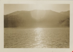
Howe Sound
https://search.heritageburnaby.ca/link/museumdescription19559
- Repository
- Burnaby Village Museum
- Date
- 1939
- Collection/Fonds
- Hawkshaw family fonds
- Description Level
- Item
- Physical Description
- 1 photograph : b&w ; 6.5 x 9 cm
- Scope and Content
- Photograph looking up Howe Sound from Britannia Beach looking towards Garibaldi Mountain.
- Repository
- Burnaby Village Museum
- Collection/Fonds
- Hawkshaw family fonds
- Description Level
- Item
- Physical Description
- 1 photograph : b&w ; 6.5 x 9 cm
- Scope and Content
- Photograph looking up Howe Sound from Britannia Beach looking towards Garibaldi Mountain.
- Subjects
- Geographic Features - Natural Geographic Features
- Geographic Features - Mountains
- Industries - Mining
- Accession Code
- BV996.6.266
- Access Restriction
- No restrictions
- Reproduction Restriction
- No known restrictions
- Date
- 1939
- Media Type
- Photograph
- Scan Date
- 2023-02-16
- Notes
- Title based on contents of photograph
- Caption on page of photograph album reads: "Spring / of / 1939"
- Photograph is part of photograph album BV996.6.1
Images

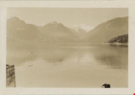
![Indian Arm, [1995] thumbnail](/media/Hpo/_Data/_Archives_Images/_Unrestricted/629/629-004.jpg?width=280)
Indian Arm
https://search.heritageburnaby.ca/link/archivedescription97803
- Repository
- City of Burnaby Archives
- Date
- [1995]
- Collection/Fonds
- Burnaby Mountain Preservation Society fonds
- Description Level
- Item
- Physical Description
- 1 photograph : col. slide ; 35 mm
- Scope and Content
- Photograph of Indian Arm.
- Repository
- City of Burnaby Archives
- Date
- [1995]
- Collection/Fonds
- Burnaby Mountain Preservation Society fonds
- Physical Description
- 1 photograph : col. slide ; 35 mm
- Description Level
- Item
- Record No.
- 629-004
- Access Restriction
- No restrictions
- Reproduction Restriction
- Reproduce for fair dealing purposes only
- Accession Number
- 2006-13
- Scope and Content
- Photograph of Indian Arm.
- Media Type
- Photograph
- Notes
- Handwritten note on slide reads: "Indian Arm."
Images
![Indian Arm, [1995] thumbnail](/media/Hpo/_Data/_Archives_Images/_Unrestricted/629/629-004.jpg)
Interview with Joe Sadowski, 2017
https://search.heritageburnaby.ca/link/museumdescription5115
- Repository
- Burnaby Village Museum
- Date
- June 16, 2017
- Collection/Fonds
- Burnaby Village Museum fonds
- Description Level
- Item
- Physical Description
- 1 sound recording (mp3) (01:46.06 min)
- Scope and Content
- Recording is an interview with Joe Sadowski conducted by Burnaby Village Museum employee Rebeca Salas, June 16, 2017. Major themes discussed: the history of the Burnaby Park Advisory Association and the Group of Ten, and the ongoing conservation of Burnaby Lake. 00:00 – 3:05: Joe discusses his inv…
- Repository
- Burnaby Village Museum
- Collection/Fonds
- Burnaby Village Museum fonds
- Series
- Museum Oral Histories series
- Subseries
- Museum research interviews subseries
- Description Level
- Item
- Physical Description
- 1 sound recording (mp3) (01:46.06 min)
- Material Details
- Interviewer: Rebeca Salas Interviewee: Joe Sadowski Date of interview: June 16, 2017 Total Number of Tracks: 1 Total Length of all Tracks: 1:46:06
- Scope and Content
- Recording is an interview with Joe Sadowski conducted by Burnaby Village Museum employee Rebeca Salas, June 16, 2017. Major themes discussed: the history of the Burnaby Park Advisory Association and the Group of Ten, and the ongoing conservation of Burnaby Lake. 00:00 – 3:05: Joe discusses his involvement with the Association from its early days in the late 1960s. He describes the formation of the group, its original intentions, and its changing focus. 3:05 - 5:54: Joe recalls how the group decided to further their purpose by involving the public, and the rationale behind building a trail system. He explains how the Burnaby Outdoor Education Association was formed and describes its activities. 5:54 – 9:20: Joe relates how the Association was able to access federal funding for the trail. He shares his perspective about local businesses having changed their priorities since that time. 9:20 – 13:31: Joe discusses how the group expanded its base, and why it changed its name to the Burnaby Lake Advisory. He explains how the trail system came to be under the jurisdiction of Metro Parks, and why the name was changed to the Burnaby Lake Park Association. He describes the shift in the group’s composition and responsibilities. 13:31 – 17:06: Rebeca notes that the museum is interested in the reasons for the group coming together in the 1960s. Joe describes how the group’s plans regarding the lake informed their subsequent activities there. He talks about the changing attitude to pollution in the 1970s. 17:06 - 22:05: Joe describes what Burnaby Lake was like in the 1960s. He discusses its importance to migrating birds, and talks about the improvement to Still Creek. 22:05 – 29:48: Joe talks about the big Burnaby Lake Clean Up. He notes that the public’s changing attitudes have made further large clean-ups unnecessary. 29:48 – 32:00: Joe talks about the work of the Eagle Creek Streamkeepers, the Sapperton Fish and Game Club, The Semiahmoo Rod and Gun Club, and the Hyde Creek Watershed Society. He observes that game clubs have broader interests now than sport alone. 32:00 – 37:37: Joe discusses the return of salmon to the lake, the improvement in the quality of water, and the increased numbers of birds. He shares his perspective that the relationship of the public to the lake changed as visitors began to take ownership. 37:37 – 39:30: Joe talks about the importance of leadership in conservation efforts, discussing how Bob Gardner and Elmer Rudolph inspired people to become involved. He describes the positive results of volunteering. 39:30 – 41:48: Asked what he feels has made the biggest difference in improving the health of the lake, Joe describes the change in the attitude of the public and contrasts this new environmental awareness with that of people in other parts of the world. 41:48 – 47:46: Joe discusses the importance of the buffer zone, and of giving students the opportunity to be involved in efforts to remove invasive species and plant native ones. 47:46 – 56:10: Joe talks about the nesting box program. He notes that interacting with wildlife may influence people’s future behavior and describes the experience as cross-cultural. 56:10 – 58:17: Joe discusses the design of the trail around the lake. 58:17 – 1:02:32: Joe mentions the advisory role of Dr. Milton McLaren in the Association’s trail building work. He remarks on the importance to the project of people such as Tony Fabian and John Thomson. Joe also discusses the material used for the trail’s construction. 1:02:32 – 1:10:53: Joe describes the Association’s relationship with the Nature House and the Wildlife Rescue Centre. He recalls the acquisition of the Nature House building. 1:10:53 – 1:19:57: Asked about consultation, Joe describes the design and construction of the trail as the only subject in which the group’s expertise was deferred to. He discusses his concerns about dredging, and mentions the installation of squirrel nesting boxes as a successful enhancement project. 1:19:57 – 1:28:05: Joe talks about how the Burnaby Lake area has changed since he moved to Burnaby in 1964, and mentions some of the detrimental effects of development. He recalls the construction of the original observation tower by Aril Dalsvaag’s students at Burnaby Central Secondary School, talks about the current tower and discusses the success of the Association’s turtle nesting pad. 1:28:05 – 1:34:50: Joe discusses the introduced species in Burnaby Lake, and the efforts to eradicate them. He mentions the work of Bob Gunn, from B.C.I.T., a former student of Bob Gardner. 1:34:50 – 1:49:28: Asked about the substances used to control the mosquito population at Burnaby Lake, Joe voices his concerns about the effects of spraying, noting that the butterfly garden has been negatively affected by it in the past. He describes the origin of the garden. 1:40:28 – 1:46:06: Rebeca summarizes the interview and thanks Joe. Joe describes his hopes for the B.L.P.A. and the future of the lake. He reiterates the importance of preservation and accessibility and remarks on the number and diversity of the visitors.
- History
- Interviewee: Joe Sadowski is a founding member of the Burnaby Lake Park Association which was formerly named the Burnaby Outdoor Education Association. He has been recognized for his environmental efforts and was awarded the Community Stewardship Star in 2000 and 2004. Interviewer: Rebeca Salas is a MA student in the Department of Geography at Simon Fraser University. Rebeca is interested in the relationship between property and memory. Rebeca is an experienced researcher and oral history interviewer and has conducted several oral histories for Landscapes of Injustice Archive.
- Creator
- Burnaby Village Museum
- Subjects
- Environmental Issues
- Environmental Issues - Environmental Protection
- Geographic Features - Streams
- Geographic Features - Natural Waterways
- Geographic Features - Parks
- Responsibility
- Salas, Rebeca
- Geographic Access
- Burnaby Lake Regional Nature Park
- Burnaby Lake
- Accession Code
- BV018.18.1
- Access Restriction
- No restrictions
- Date
- June 16, 2017
- Media Type
- Sound Recording
Audio Tracks
Interview with Joe Sadowski, 2017, June 16, 2017
Interview with Joe Sadowski, 2017, June 16, 2017
https://search.heritageburnaby.ca/media/hpo/_Data/_BVM_Sound_Recordings/Oral_Histories/2018_0018_0001_001.mp3Interview with John Templeton, Alan James and Christine Leston by Kathy Bossort October 26, 2015 - Track 9
https://search.heritageburnaby.ca/link/oralhistory595
- Repository
- City of Burnaby Archives
- Date Range
- 1995-2015
- Length
- 0:12:28
- Summary
- This portion of the interview is about the Stoney Creek Environment Committee members’ discussion of how the history of the forest and natural area on Burnaby Mountain forms part of our appreciation for the mountain. They talk about the impact of the conservation area on adjacent urban areas such a…
- Repository
- City of Burnaby Archives
- Summary
- This portion of the interview is about the Stoney Creek Environment Committee members’ discussion of how the history of the forest and natural area on Burnaby Mountain forms part of our appreciation for the mountain. They talk about the impact of the conservation area on adjacent urban areas such as the neighbourhood of Forest Grove, and the future of the urban forest on Burnaby Mountain.
- Date Range
- 1995-2015
- Length
- 0:12:28
- Geographic Access
- Burnaby Mountain Conservation Area
- Stoney Creek
- Interviewer
- Bossort, Kathy
- Interview Date
- October 26, 2015
- Scope and Content
- Recording is of an interview with John Templeton, Alan James & Christine Leston, members of the Stoney Creek Environment Committee, conducted by Kathy Bossort. The three members of SCEC were among 23 participants interviewed as part of the Community Heritage Commission’s Burnaby Mountain Oral History Project. The interview is mainly about the history and work of the stream keeper group Stoney Creek Environment Committee (SCEC) and the Stoney Creek Environmental Working Group, and about SCEC’s founder Jennifer Atkinson. The interview is made richer by the complementary views of the three interviewees, John Templeton (SCEC Chair), Alan James (Member-at-Large - Education), and Christine Leston (Treasurer).
- Biographical Notes
- The Stoney Creek Environment Committee is a streamkeeper group and registered non-profit society dedicated to protecting and restoring viable salmon-bearing streams within the Stoney Creek Watershed. (Stoney Creek originates on Burnaby Mountain and is part of the Brunette watershed which empties into the Fraser River.) The volunteer group, formed in 1995, was guided by the tireless efforts of Jennifer Atchison (1938-2010) after whom the Jennifer Atchison Environmental Centre in North Burnaby is named. The volunteer members of SCEC monitor water quality, generate inventories and reports on the biophysical assets and health of the watershed, provide educational opportunities, enhance stream and stream bank habitat, and speak on behalf of the Stoney Creek watershed. One of its key events is The Great Salmon Send-Off, the release of young salmon into Stoney Creek in May, which celebrated its 25th anniversary in 2015. The Stoney Creek Environmental Working Group (1999-present), managed by the City of Burnaby, undertakes to coordinate the actions of all stakeholders in the Stoney Creek watershed. It is comprised of representatives from community groups, such as SCEC, governmental and institutional agencies, and industries who are committed to sustaining and improving the quality of the Stoney Creek watershed’s water, wildlife and environment. John Templeton, currently SCEC Chair, joined SCEC in 2004. He was born in Coleraine ,County Londonderry, Northern Ireland, in 1957, and after immigrating to Canada, came to live in Burnaby in 1992, first in Forest Grove (1992-2014) and then in Forest Hills. He works as a millwright. Alan James,Member-at-large - Education, joined SCEC in 2003 He was born in 1939 in Berkeley, California, and came to live in Burnaby in about 2000. He is a retired geophycisist and computer consultant. Christine Leston joined SCEC in 1997, serving first as Secretary and then as Treasurer. She was born in 1943 in Cheshire, England, and came to live in Burnaby in 1974, first in Greentree Village, then Simon Fraser Village (1974-2004) and now the Edmonds area. She is a retired technical writer.
- Total Tracks
- 9
- Total Length
- 2:08:27
- Interviewee Name
- Templeton, John R.
- James, Alan C.
- Leston, Christine
- Interview Location
- Jennifer Atchison Environmental Centre, Burnaby
- Interviewer Bio
- Kathy Bossort is a retired archivist living in Ladner, BC. She worked at the Delta Museum and Archives after graduating from SLAIS (UBC) in 2001 with Masters degrees in library science and archival studies. Kathy grew up in Calgary, Alberta, and, prior to this career change, she lived in the West Kootenays, earning her living as a cook for BC tourist lodges and work camps. She continues to be interested in oral histories as a way to fill the gaps in the written record and bring richer meaning to history.
- Collection/Fonds
- Community Heritage Commission Special Projects fonds
- Media Type
- Sound Recording
Audio Tracks
Track nine of interview with John Templeton, Alan James & Christine Leston
Track nine of interview with John Templeton, Alan James & Christine Leston
https://search.heritageburnaby.ca/media/hpo/_Data/_Archives_Oral_Histories/_Unrestricted/MSS196-006/MSS196-006_Track_9.mp3Locations in Vancouver and British Columbia
https://search.heritageburnaby.ca/link/archivedescription58315
- Repository
- City of Burnaby Archives
- Date
- [19--]
- Collection/Fonds
- Burnaby Historical Society fonds
- Description Level
- Item
- Physical Description
- 1 album (61 photographs : b&w) ; 26.5 x 31.5 cm
- Scope and Content
- Photographic album of locations in Vancouver, the Lower Mainland, and other locations in British Columbia and Alberta. Photographs are reproductions of photographs taken between approximately 1880-1900, which were collected and pasted into the album.
- Repository
- City of Burnaby Archives
- Date
- [19--]
- Collection/Fonds
- Burnaby Historical Society fonds
- Subseries
- Fraser Wilson subseries
- Physical Description
- 1 album (61 photographs : b&w) ; 26.5 x 31.5 cm
- Description Level
- Item
- Record No.
- 492-001
- Access Restriction
- In Archives only
- Reproduction Restriction
- No reproduction permitted
- Accession Number
- BHS1988-06
- Scope and Content
- Photographic album of locations in Vancouver, the Lower Mainland, and other locations in British Columbia and Alberta. Photographs are reproductions of photographs taken between approximately 1880-1900, which were collected and pasted into the album.
- Names
- Wilson, Fraser
- Media Type
- Photograph
- Notes
- Title based on content of item
- Table of contents of pictures and page numbers pasted in the front cover of the album
- 1 photograph loose in between pages 12-13 of the album; reproduction of a photograph from Vancouver City Archives.
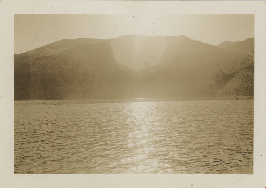
Looking across Howe Sound
https://search.heritageburnaby.ca/link/museumdescription19517
- Repository
- Burnaby Village Museum
- Date
- 1938
- Collection/Fonds
- Hawkshaw family fonds
- Description Level
- Item
- Physical Description
- 1 photograph : sepia ; 6.5 x 9 cm
- Scope and Content
- Photograph looking across Howe Sound from Britannia Beach.
- Repository
- Burnaby Village Museum
- Collection/Fonds
- Hawkshaw family fonds
- Description Level
- Item
- Physical Description
- 1 photograph : sepia ; 6.5 x 9 cm
- Scope and Content
- Photograph looking across Howe Sound from Britannia Beach.
- Accession Code
- BV996.6.224
- Access Restriction
- No restrictions
- Reproduction Restriction
- No known restrictions
- Date
- 1938
- Media Type
- Photograph
- Scan Resolution
- 600
- Scan Date
- 2023-02-16
- Notes
- Title based on contents of photograph
- Photograph caption beneath photograph reads: "Looking across the sound"
- Photograph is part of photograph album BV996.6.1
Images