Armstrong Street School site
https://search.heritageburnaby.ca/link/museumdescription11133
- Repository
- Burnaby Village Museum
- Date
- 1915
- Collection/Fonds
- Ronald G. Scobbie collection
- Description Level
- Item
- Physical Description
- 1 survey plan : blueprint on paper ; 56 x 54 cm
- Scope and Content
- Survey plan of "Armstrong Street School Site / Burnaby Municipality" "Being a 2 acre portion of Lot 13 Group 1, & according to map 1722 which shows this as Lot E. Block 2 of subdivision of a portion, of Lot 13, Group 1, New Westminster District".
- Repository
- Burnaby Village Museum
- Collection/Fonds
- Ronald G. Scobbie collection
- Description Level
- Item
- Physical Description
- 1 survey plan : blueprint on paper ; 56 x 54 cm
- Material Details
- Scale 40 feet = 1 inch
- Scope and Content
- Survey plan of "Armstrong Street School Site / Burnaby Municipality" "Being a 2 acre portion of Lot 13 Group 1, & according to map 1722 which shows this as Lot E. Block 2 of subdivision of a portion, of Lot 13, Group 1, New Westminster District".
- Creator
- Burnett, Geoffrey K.
- Subjects
- Buildings - Schools
- Names
- Armstrong Avenue School
- Responsibility
- Burnett & McGugan, Engineers and Surveyors
- Geographic Access
- Armstrong Avenue
- Street Address
- 8757 Armstrong Avenue
- Accession Code
- BV003.83.12
- Access Restriction
- No restrictions
- Reproduction Restriction
- No known restrictions
- Date
- 1915
- Media Type
- Cartographic Material
- Historic Neighbourhood
- East Burnaby (Historic Neighbourhood)
- Planning Study Area
- Cariboo-Armstrong Area
- Scan Resolution
- 440
- Scan Date
- 22-Dec-2020
- Scale
- 100
- Notes
- Title based on contents of plan
- Note in black ink on verso of plan reads: "1746"
- Oath on plan reads: "I, Geoffrey K. Burnett...and did personally superintend the survey represented..." "Completed on the 18th day of March 1915"; signed by Geoffrey K. Burnett and notarized by "K.A. Eastman", sworn "...19th day of April 1915"; "Burnett and McGugan., B.C. Land Surveyors. Etc.. New Westminster, B.C.."
Zoomable Images


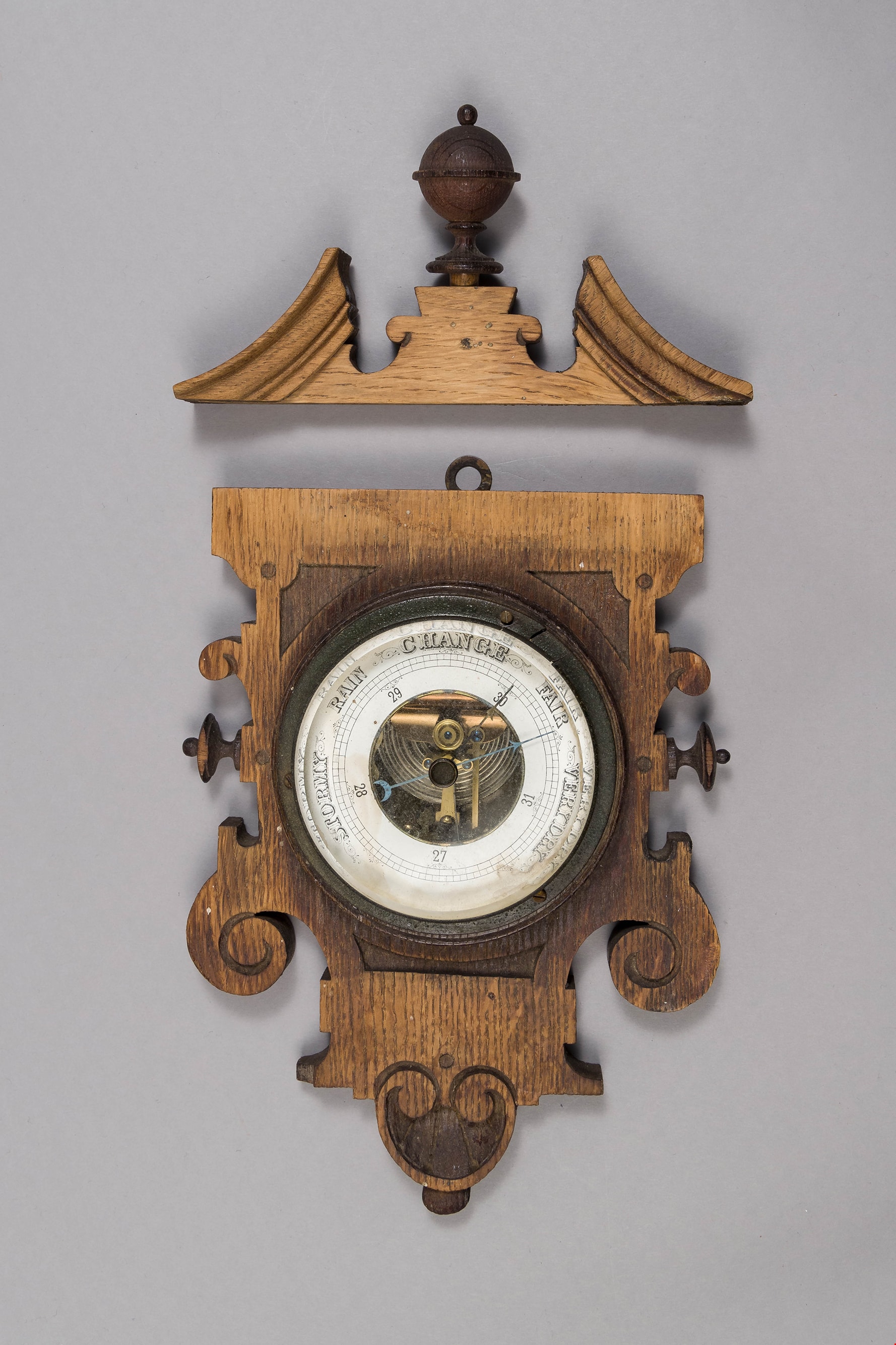
barometer
https://search.heritageburnaby.ca/link/museumartifact90178
- Repository
- Burnaby Village Museum
- Accession Code
- BV019.8.16
- Description
- barometer; aneroid barometer secured to a carved wood plaque; barometer has a calibrated dial to indicate air pressure; text on dial reads: "VERY DRY", "FAIR", "CHANGE", "RAIN", and "STORMY"; flat metal loop at top of wood plaque for hanging. Dark stained carved wood decorative scroll with finial; has detached from base plaque.
- Object History
- Object used in the Love Farmhouse, currently on site at Burnaby Village Museum.
- Geographic Access
- Cumberland Street
- Street Address
- 7651 Cumberland Street
- Historic Neighbourhood
- East Burnaby (Historic Neighbourhood)
- Planning Study Area
- Cariboo-Armstrong Area
Images
![Bird's eye view of New Westminster, Burnaby and Vancouver, [ca. 1911] thumbnail](/media/hpo/_Data/_BVM_Cartographic_Material/1983/1983_0012_0001_002%20Web.jpg?width=280)
Bird's eye view of New Westminster, Burnaby and Vancouver
https://search.heritageburnaby.ca/link/museumdescription8199
- Repository
- Burnaby Village Museum
- Date
- [ca. 1911]
- Collection/Fonds
- Burnaby Village Museum Map collection
- Description Level
- Item
- Physical Description
- 1 map : hand painted ; 65.5 x 99 cm
- Scope and Content
- An untitled monochromatic grayscale map of a developer's bird's eye view looking north west from Burnaby Mountain. View includes Burnaby, New Westminster, Vancouver with the North shore in the distance. Burnaby neighbourhood subdivisions of "Burnaby Heights" and "Buena Vista" are featured near the…
- Repository
- Burnaby Village Museum
- Collection/Fonds
- Burnaby Village Museum Map collection
- Description Level
- Item
- Physical Description
- 1 map : hand painted ; 65.5 x 99 cm
- Scope and Content
- An untitled monochromatic grayscale map of a developer's bird's eye view looking north west from Burnaby Mountain. View includes Burnaby, New Westminster, Vancouver with the North shore in the distance. Burnaby neighbourhood subdivisions of "Burnaby Heights" and "Buena Vista" are featured near the centre of the map. These neighbourhood subdivisions were marketed by Real Estate Agents Liebly & Blumer in 1911. Roads, buildings, factories, railways and bridges are identified on the map.
- Subjects
- Businesses - Real Estate Agencies
- Responsibility
- Leibly & Blumer Realty Co. Incorporated
- Accession Code
- HV983.12.1
- Access Restriction
- No restrictions
- Reproduction Restriction
- No known restrictions
- Date
- [ca. 1911]
- Media Type
- Cartographic Material
- Historic Neighbourhood
- East Burnaby (Historic Neighbourhood)
- Vancouver Heights (Historic Neighbourhood)
- Planning Study Area
- Cariboo-Armstrong Area
- Burnaby Heights Area
- Scan Resolution
- 300
- Scan Date
- December 2020
- Scale
- 100
- Notes
- Title based on contents of map
- Note in pencil on verso of photograph reads: "Make tint block of Buena Vista / Blocks only as shown in lots"
Zoomable Images
![Bird's eye view of New Westminster, Burnaby and Vancouver, [ca. 1911] thumbnail](/media/hpo/_Data/_BVM_Cartographic_Material/1983/1983_0012_0001_001_seadragon/1983_0012_0001_001.jpg?w=280)

building
https://search.heritageburnaby.ca/link/museumartifact3846
- Repository
- Burnaby Village Museum
- Accession Code
- BV988.33.1
- Description
- The core of the Jessie Love farm house is a 1893 two story, pioneer tent style building. The home was added to over the years and became a large Craftsmen style farm house.
- Object History
- Built on Cumberland Road in Burnaby in 1893. Music Room/Parlour/Living Room and bedrooms above added c.1898. Kitchen added c.1908. The home of Jesse and Martha Love and their eleven children. One of Burnaby's oldest structures. The home was moved to Burnaby Village Museum in the late 1980s and has been partially restored to its 1920s appearance.
- Category
- 01. Built Environment Objects
- Classification
- Structures - - Dwellings
- Object Term
- House
- Colour
- Brown
- Culture
- Canadian
- Geographic Access
- Cumberland Street
- Street Address
- 6501 Deer Lake Avenue
- Historic Neighbourhood
- East Burnaby (Historic Neighbourhood)
- Planning Study Area
- Cariboo-Armstrong Area
Images


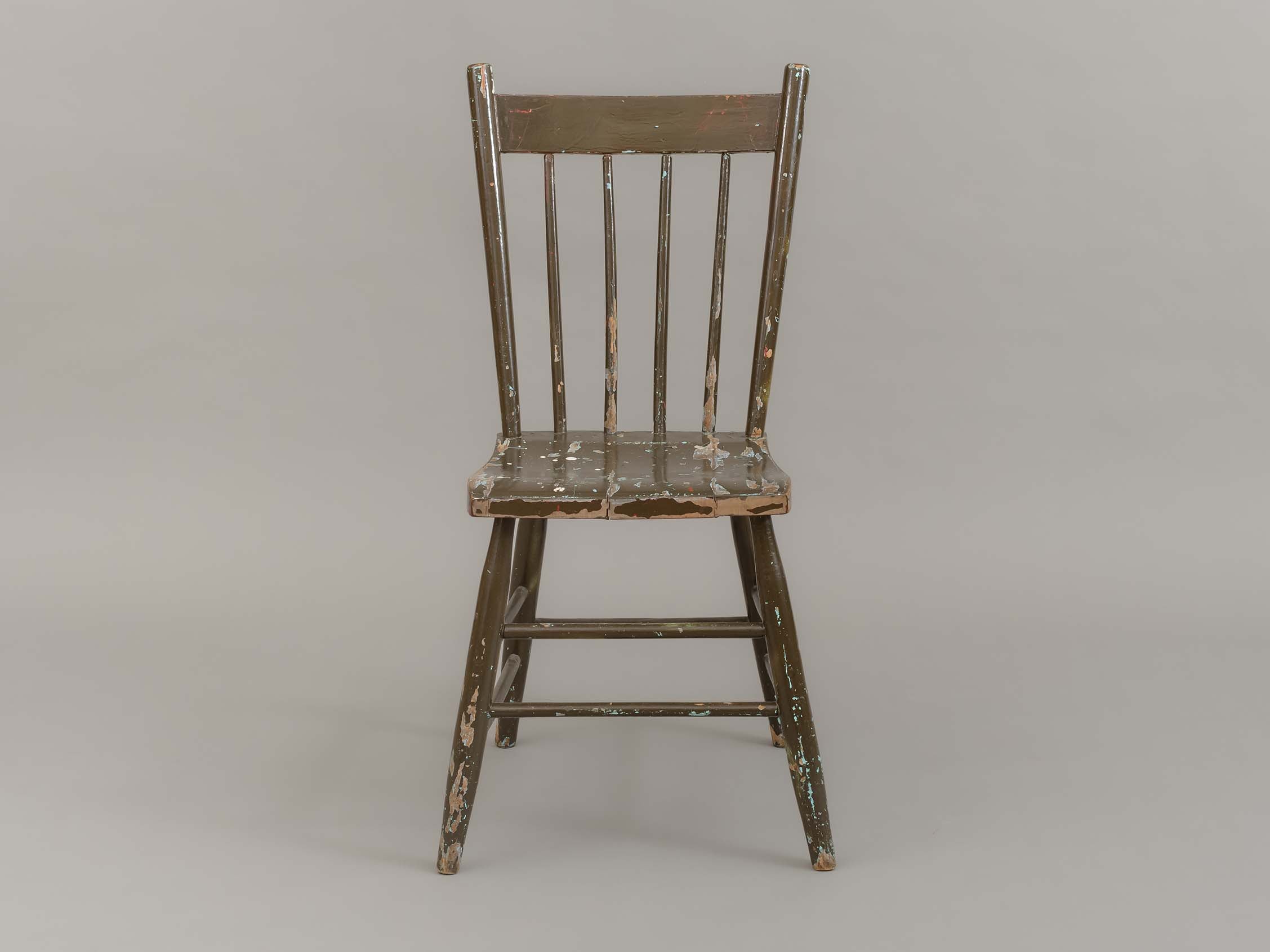
dining chair
https://search.heritageburnaby.ca/link/museumartifact90002
- Repository
- Burnaby Village Museum
- Accession Code
- BV019.8.15
- Description
- dining chair; side chair; brown painted wood; chair back has four vertical spindles; two horizontal stretchers between front and side legs; one horizontal stretcher between back legs.
- Object History
- Object used in the dining room of the Love farmhouse. The layers of paint beneath the brown outer layer reveal past colours of the chair that are documented in BVM photographs of the interior of the Love farmhouse.
- Category
- 02. Furnishings
- Classification
- Furniture - - Seating Furniture
- Object Term
- Chair
- Subjects
- Furniture
- Geographic Access
- Cumberland Street
- Street Address
- 7651 Cumberland Street
- Historic Neighbourhood
- East Burnaby (Historic Neighbourhood)
- Planning Study Area
- Cariboo-Armstrong Area
Images

Municipality of Burnaby - Volume XV, Volume XVI, Volume XVII, Volume XVIII
https://search.heritageburnaby.ca/link/museumdescription8685
- Repository
- Burnaby Village Museum
- Date
- May 1927
- Collection/Fonds
- Burnaby Village Museum Map collection
- Description Level
- File
- Physical Description
- 4 plans on 4 sheets : col. lithographic prints ; 63.5 x 53.5 cm folded to 53 x 31.5 cm
- Scope and Content
- File consists of four pages of plans removed from a bound book containing a series of fire insurance plans of the Municipality of Burnaby. Plan "1531" is part of "GREATER VANCOUVER B.C. / VOLUME XV / Municipality of Burnaby / May 1927" and covers District Lots: 116 and 117. Key Plan "C" is part of …
- Repository
- Burnaby Village Museum
- Collection/Fonds
- Burnaby Village Museum Map collection
- Description Level
- File
- Physical Description
- 4 plans on 4 sheets : col. lithographic prints ; 63.5 x 53.5 cm folded to 53 x 31.5 cm
- Material Details
- Scale [1:600] and [1:1200]
- Scope and Content
- File consists of four pages of plans removed from a bound book containing a series of fire insurance plans of the Municipality of Burnaby. Plan "1531" is part of "GREATER VANCOUVER B.C. / VOLUME XV / Municipality of Burnaby / May 1927" and covers District Lots: 116 and 117. Key Plan "C" is part of "GREATER VANCOUVER B.C. / VOLUME XVI / Municipality of Burnaby / May 1927" and covers plans 1623 to 1651 and District Lots: 1 and 2; 4; 6; 8; 10 to 14; 25; 27; 40; 56 to 58; 88 and 89. Plan "1738" is part of "GREATER VANCOUVER B.C. / VOLUME XVII / Municipality of Burnaby / May 1927" and covers District Lots: 34 and 35. Key plan "G" is part of "GREATER VANCOUVER B.C. / VOLUME XVIII / Municipality of Burnaby / May 1927" and covers plans: 1801 to 1813; 1823; 1824; 1833 to 1838; 1841 to 1853 and District Lots: 32; 93; 94; 97 to 99; 149; 150; 152; 155 to 159; 161 to 164.
- Responsibility
- British Columbia Underwriters' Association
- Accession Code
- HV972.111.7
- Access Restriction
- No restrictions
- Reproduction Restriction
- May be restricted by third party rights
- Date
- May 1927
- Media Type
- Cartographic Material
- Historic Neighbourhood
- Central Park (Historic Neighbourhood)
- Fraser Arm (Historic Neighbourhood)
- Alta Vista (Historic Neighbourhood)
- Broadview (Historic Neighbourhood)
- Vancouver Heights (Historic Neighbourhood)
- Burquitlam (Historic Neighbourhood)
- East Burnaby (Historic Neighbourhood)
- Edmonds (Historic Neighbourhood)
- Lozells (Historic Neighbourhood)
- Planning Study Area
- Clinton-Glenwood Area
- Marlborough Area
- Maywood Area
- Windsor Area
- Big Bend Area
- Garden Village Area
- Willingdon Heights Area
- West Central Valley Area
- Cariboo-Armstrong Area
- Lyndhurst Area
- Cameron Area
- Lake City Area
- Edmonds Area
- Second Street Area
- Sperling-Broadway Area
- Lakeview-Mayfield Area
- Scan Resolution
- 400
- Scan Date
- 2021-11-18
- Notes
- Title based on content of plans
- See also BV987.1.70d for revised versions of plans
- Scale is measured 1 inch = 500 feet
Zoomable Images

Municipality of Burnaby - Volume XV, Volume XVI, Volume XVII, Volume XVIII, May 1927
Zoom into Image

Plan of Subdivision of Block F Lot 1, D.L. 25 Group 1
https://search.heritageburnaby.ca/link/museumdescription18808
- Repository
- Burnaby Village Museum
- Date
- 17 Apr. 1912
- Collection/Fonds
- Love family fonds
- Description Level
- Item
- Physical Description
- 1 plan : black and red ink on linen ; 36 x 28.5 cm
- Scope and Content
- Item consists of Plan of Subdivision of Block F Lot 1, D.L. 25 Group 1 New Westminster District created by Provincial Land Surveyor Geoffrey K. Burnett.
- Repository
- Burnaby Village Museum
- Collection/Fonds
- Love family fonds
- Description Level
- Item
- Physical Description
- 1 plan : black and red ink on linen ; 36 x 28.5 cm
- Material Details
- Scale [1:1200]
- Scope and Content
- Item consists of Plan of Subdivision of Block F Lot 1, D.L. 25 Group 1 New Westminster District created by Provincial Land Surveyor Geoffrey K. Burnett.
- Creator
- Burnett, Geoffrey K.
- Names
- Burnett, Geoffrey K.
- Geographic Access
- Cumberland Street
- Accession Code
- BV992.26.28
- Access Restriction
- No restrictions
- Reproduction Restriction
- No known restrictions
- Date
- 17 Apr. 1912
- Media Type
- Cartographic Material
- Historic Neighbourhood
- East Burnaby (Historic Neighbourhood)
- Planning Study Area
- Cariboo-Armstrong Area
- Scan Resolution
- 600
- Scan Date
- 2022-07-11
- Scale
- 100
- Notes
- Title based on contents of item
- Scale is measured "100 FT = 1 INCH"
- "PLAN OF SUBDIVISION OF BLOCK "F" OF LOT 1, D.L. 25 GROUP 1. NEW WESTMINSTER DISTRICT"; Wright St., Sixth Ave., Fifth Ave., Cumberland St., L.1-8, 11-16; signature of Jesse Love, owner, witness S.P. King?; Geoffrey K. Burnett, P.L.S.; Fred A. Macpherson, Municipal Clerk, April 17, 1912; taxes paid to Dec. 31 1911, signed April 17 1912 by W.H. Griffin, collector"
Images


Plan of Subdivision of Block F Lot 1, D.L. 25 Group 1
https://search.heritageburnaby.ca/link/museumdescription18809
- Repository
- Burnaby Village Museum
- Date
- 17 Apr. 1912
- Collection/Fonds
- Love family fonds
- Description Level
- Item
- Physical Description
- 1 plan : black and red ink on linen ; 36 x 28.5 cm
- Scope and Content
- Item consists of Plan of Subdivision of Block F Lot 1, D.L. 25 Group 1 New Westminster District created by Provincial Land Surveyor Geoffrey K. Burnett.
- Repository
- Burnaby Village Museum
- Collection/Fonds
- Love family fonds
- Description Level
- Item
- Physical Description
- 1 plan : black and red ink on linen ; 36 x 28.5 cm
- Material Details
- Scale [1:1200]
- Scope and Content
- Item consists of Plan of Subdivision of Block F Lot 1, D.L. 25 Group 1 New Westminster District created by Provincial Land Surveyor Geoffrey K. Burnett.
- Creator
- Burnett, Geoffrey K.
- Names
- Burnett, Geoffrey K.
- Geographic Access
- Cumberland Street
- Accession Code
- BV992.26.29
- Access Restriction
- No restrictions
- Reproduction Restriction
- No known restrictions
- Date
- 17 Apr. 1912
- Media Type
- Cartographic Material
- Historic Neighbourhood
- East Burnaby (Historic Neighbourhood)
- Planning Study Area
- Cariboo-Armstrong Area
- Scan Resolution
- 600
- Scan Date
- 2022-07-11
- Scale
- 100
- Notes
- Title based on contents of item
- Scale is measured "100 FT = 1 INCH"
- "PLAN OF SUBDIVISION OF BLOCK "F" OF LOT 1, D.L. 25 GROUP 1. NEW WESTMINSTER DISTRICT"; Wright St., Sixth Ave., Fifth Ave., Cumberland St., L.1-8, 11-16; signature of Jesse Love, owner, witness S.P. King?; Geoffrey K. Burnett, P.L.S.; Fred A. Macpherson, Municipal Clerk, April 17, 1912; taxes paid to Dec. 31 1911, signed April 17 1912 by W.H. Griffin, collector"
Images

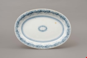
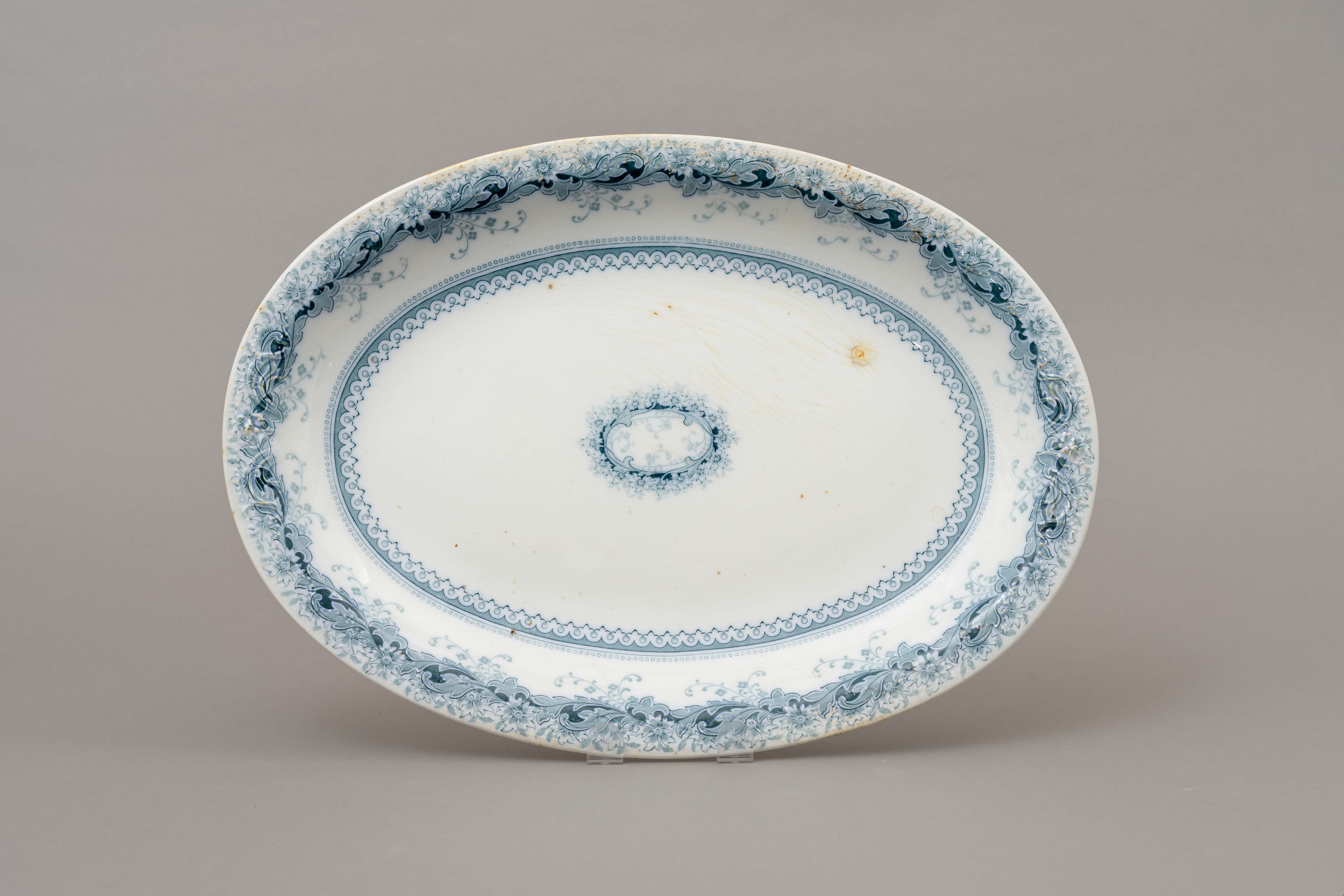
platter
https://search.heritageburnaby.ca/link/museumartifact83513
- Repository
- Burnaby Village Museum
- Accession Code
- BV013.22.1
- Description
- Serving platter, 16 X 12 inches. Made by J & G Meakin, Hanley, England. It is a [C]haplet patern. Blue patern with raised dots around the top edge. The patern is raised on the short sides of the oval. There is a chip on the inside of the bottom surface. "21 is pressed into the underside.
- Object History
- This platter was handed down from Martha Love through three generations to the donor.
- Reference
- http://en.wikipedia.org/wiki/J._%26_G._Meakin - short history of J & G Meakin.
- Maker
- J. & G. Meakin Limited
- Country Made
- England
- Site/City Made
- Hanley
- Historic Neighbourhood
- East Burnaby (Historic Neighbourhood)
- Planning Study Area
- Cariboo-Armstrong Area
Images