![Burnaby real estate, [2003] thumbnail](/media/hpo/_Data/_Archives_Images/_Unrestricted/535/535-1813.jpg?width=280)
Burnaby real estate
https://search.heritageburnaby.ca/link/archivedescription96107
- Repository
- City of Burnaby Archives
- Date
- [2003]
- Collection/Fonds
- Burnaby NewsLeader photograph collection
- Description Level
- Item
- Physical Description
- 1 photograph (tiff) : col.
- Scope and Content
- Photograph of realtor Phil Moore leaning against a real estate sign that says "Sold." The exterior of a home is in the background.
- Repository
- City of Burnaby Archives
- Date
- [2003]
- Collection/Fonds
- Burnaby NewsLeader photograph collection
- Physical Description
- 1 photograph (tiff) : col.
- Description Level
- Item
- Record No.
- 535-1813
- Access Restriction
- No restrictions
- Reproduction Restriction
- No restrictions
- Accession Number
- 2018-12
- Scope and Content
- Photograph of realtor Phil Moore leaning against a real estate sign that says "Sold." The exterior of a home is in the background.
- Media Type
- Photograph
- Photographer
- Bartel, Mario
- Notes
- Title based on caption
- Collected by editorial for use in a January 2003 issue of the Burnaby NewsLeader
- Caption from metadata: "Times are good for local realtors like Phil Moore, as Burnaby enjoys a real estate boom."
Images
![Burnaby real estate, [2003] thumbnail](/media/hpo/_Data/_Archives_Images/_Unrestricted/535/535-1813.jpg)
![Commercial realtor Scott Brown, [2002] thumbnail](/media/hpo/_Data/_Archives_Images/_Unrestricted/535/535-1970.jpg?width=280)
Commercial realtor Scott Brown
https://search.heritageburnaby.ca/link/archivedescription96287
- Repository
- City of Burnaby Archives
- Date
- [2002]
- Collection/Fonds
- Burnaby NewsLeader photograph collection
- Description Level
- Item
- Physical Description
- 1 photograph (tiff) : col.
- Scope and Content
- Photograph of commercial real estate broker Scott Brown. Brown is standing in front of the Madison Centre on Lougheed Highway with his arms wide open. A sign in the window of the office tower reads: "For Lease."
- Repository
- City of Burnaby Archives
- Date
- [2002]
- Collection/Fonds
- Burnaby NewsLeader photograph collection
- Physical Description
- 1 photograph (tiff) : col.
- Description Level
- Item
- Record No.
- 535-1970
- Access Restriction
- No restrictions
- Reproduction Restriction
- No restrictions
- Accession Number
- 2018-12
- Scope and Content
- Photograph of commercial real estate broker Scott Brown. Brown is standing in front of the Madison Centre on Lougheed Highway with his arms wide open. A sign in the window of the office tower reads: "For Lease."
- Media Type
- Photograph
- Photographer
- Bartel, Mario
- Notes
- Title based on caption
- Collected by editorial for use in a February 2002 issue of the Burnaby NewsLeader
- Caption from metadata: "Scott Brown, a commercial real estate broker, says things are looking up for businesses looking for office space in Burnaby, as new space in buildings like the Madison Centre have increased the vacancy rates."
- Geographic Access
- Lougheed Highway
- Planning Study Area
- Brentwood Area
Images
![Commercial realtor Scott Brown, [2002] thumbnail](/media/hpo/_Data/_Archives_Images/_Unrestricted/535/535-1970.jpg)
Interior of realestate office at Burnaby Village Museum
https://search.heritageburnaby.ca/link/museumdescription13767
- Repository
- Burnaby Village Museum
- Date
- Sept. 1987
- Collection/Fonds
- Century Park Museum Association fonds
- Description Level
- Item
- Physical Description
- 1 photograph : col. ; 9 x 12.5 cm
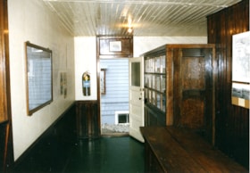
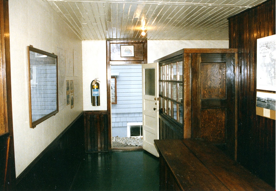
- Scope and Content
- Photograph of the interior of the realestate office at Burnaby Village Museum.
- Repository
- Burnaby Village Museum
- Collection/Fonds
- Century Park Museum Association fonds
- Description Level
- Item
- Physical Description
- 1 photograph : col. ; 9 x 12.5 cm
- Scope and Content
- Photograph of the interior of the realestate office at Burnaby Village Museum.
- Names
- Burnaby Village Museum
- Geographic Access
- Deer Lake Avenue
- Accession Code
- BV020.5.965
- Access Restriction
- No restrictions
- Reproduction Restriction
- No known restrictions
- Date
- Sept. 1987
- Media Type
- Photograph
- Scan Resolution
- 600
- Scan Date
- 22-Sep-2020
- Scale
- 100
- Notes
- Title based on contents of photograph
Images
Interior of real estate office at Burnaby Village Museum
https://search.heritageburnaby.ca/link/museumdescription13774
- Repository
- Burnaby Village Museum
- Date
- Sept. 1987
- Collection/Fonds
- Century Park Museum Association fonds
- Description Level
- Item
- Physical Description
- 1 photograph : col. ; 9 x 12.5 cm
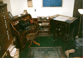
- Scope and Content
- Photograph of the interior of Burnaby Village Museum realestate office. Office is furnished with a roll top desk, chair, metal safe, typewriter and other office equipment.
- Repository
- Burnaby Village Museum
- Collection/Fonds
- Century Park Museum Association fonds
- Description Level
- Item
- Physical Description
- 1 photograph : col. ; 9 x 12.5 cm
- Scope and Content
- Photograph of the interior of Burnaby Village Museum realestate office. Office is furnished with a roll top desk, chair, metal safe, typewriter and other office equipment.
- Names
- Burnaby Village Museum
- Geographic Access
- Deer Lake Avenue
- Accession Code
- BV020.5.964
- Access Restriction
- No restrictions
- Reproduction Restriction
- No known restrictions
- Date
- Sept. 1987
- Media Type
- Photograph
- Scan Resolution
- 600
- Scan Date
- 22-Sep-2020
- Scale
- 100
- Notes
- Title based on contents of photograph
Images

![Real Estate - Surveyor's office building, [1977] thumbnail](/media/hpo/_Data/_BVM_Images/2020/2020_0005_1509_001.jpg?width=280)
Real Estate - Surveyor's office building
https://search.heritageburnaby.ca/link/museumdescription14680
- Repository
- Burnaby Village Museum
- Date
- [1977]
- Collection/Fonds
- Century Park Museum Association fonds
- Description Level
- Item
- Physical Description
- 1 photograph : col. slide ; 35 mm
- Scope and Content
- Photograph of the Real Estate Office and Surveyor's building being moved and installed on the southeast end of Hill Street inside of Heritage Village. The building is elevated on wood cribbing piles prior to being lowered over he foundation area. The Royal Bank building is visible to the right.
- Repository
- Burnaby Village Museum
- Collection/Fonds
- Century Park Museum Association fonds
- Description Level
- Item
- Physical Description
- 1 photograph : col. slide ; 35 mm
- Scope and Content
- Photograph of the Real Estate Office and Surveyor's building being moved and installed on the southeast end of Hill Street inside of Heritage Village. The building is elevated on wood cribbing piles prior to being lowered over he foundation area. The Royal Bank building is visible to the right.
- History
- The building was originally located at 3043 (pre-1958) / 6108 Patterson Avenue, Lot 22, Block 33, District Lot 151, Plan 2002. It was built ca. 1929, possibly by Mr. Cuthbert Pratt. Over the years it was used as a confectionary store, grocery store, home, and small boarding house. By 1977, it was operating as the Magee Grocery Store. The building was moved to BVM in May 1977 and then adapted to look like the original Dow, Fraser & Co. Ltd. real estate building.
- Names
- Burnaby Village Museum
- Accession Code
- BV020.5.1509
- Access Restriction
- No restrictions
- Reproduction Restriction
- No known restrictions
- Date
- [1977]
- Media Type
- Photograph
- Scan Resolution
- 2400
- Scan Date
- 17-Nov-2020
- Scale
- 100
- Notes
- Title based on contents of photograph
Images
![Real Estate - Surveyor's office building, [1977] thumbnail](/media/hpo/_Data/_BVM_Images/2020/2020_0005_1509_001.jpg)
![Real Estate - Surveyor's office building, [1977] thumbnail](/media/hpo/_Data/_BVM_Images/2020/2020_0005_1512_001.jpg?width=280)
Real Estate - Surveyor's office building
https://search.heritageburnaby.ca/link/museumdescription14684
- Repository
- Burnaby Village Museum
- Date
- [1977]
- Collection/Fonds
- Century Park Museum Association fonds
- Description Level
- Item
- Physical Description
- 1 photograph : col. slide ; 35 mm
- Scope and Content
- Photograph of the Real Estate Office and Surveyor's building on the southeast end of Hill Street inside of Heritage Village. Exterior signage above the door and window reads: "BRANCH / DOW, FRASER & CO LIMITED / (A TRUST COMPANY) / REAL ESTATE_LOANS_FIRE INSURANCE" ; "REAL ESTATE".
- Repository
- Burnaby Village Museum
- Collection/Fonds
- Century Park Museum Association fonds
- Description Level
- Item
- Physical Description
- 1 photograph : col. slide ; 35 mm
- Scope and Content
- Photograph of the Real Estate Office and Surveyor's building on the southeast end of Hill Street inside of Heritage Village. Exterior signage above the door and window reads: "BRANCH / DOW, FRASER & CO LIMITED / (A TRUST COMPANY) / REAL ESTATE_LOANS_FIRE INSURANCE" ; "REAL ESTATE".
- History
- The building was originally located at 3043 (pre-1958) / 6108 Patterson Avenue, Lot 22, Block 33, District Lot 151, Plan 2002. It was built ca. 1929, possibly by Mr. Cuthbert Pratt. Over the years it was used as a confectionary store, grocery store, home, and small boarding house. By 1977, it was operating as the Magee Grocery Store. The building was moved to BVM in May 1977 and then adapted to look like the original Dow, Fraser & Co. Ltd. real estate building.
- Names
- Burnaby Village Museum
- Accession Code
- BV020.5.1512
- Access Restriction
- No restrictions
- Reproduction Restriction
- No known restrictions
- Date
- [1977]
- Media Type
- Photograph
- Scan Resolution
- 2400
- Scan Date
- 17-Nov-2020
- Scale
- 100
- Notes
- Title based on contents of photograph
Images
![Real Estate - Surveyor's office building, [1977] thumbnail](/media/hpo/_Data/_BVM_Images/2020/2020_0005_1512_001.jpg)
![Real Estate - Surveyor's office building, [1977] thumbnail](/media/hpo/_Data/_BVM_Images/2020/2020_0005_1515_001.jpg?width=280)
Real Estate - Surveyor's office building
https://search.heritageburnaby.ca/link/museumdescription14687
- Repository
- Burnaby Village Museum
- Date
- [1977]
- Collection/Fonds
- Century Park Museum Association fonds
- Description Level
- Item
- Physical Description
- 1 photograph : col. slide ; 35 mm
- Scope and Content
- Photograph of the south side of Real Estate Office and Surveyor's building newly installed at the southeast corner of Hill Street inside of Heritage Village. Two large picture windows and entrance door to the Hill & Burnett Surveyor's office have been installed.
- Repository
- Burnaby Village Museum
- Collection/Fonds
- Century Park Museum Association fonds
- Description Level
- Item
- Physical Description
- 1 photograph : col. slide ; 35 mm
- Scope and Content
- Photograph of the south side of Real Estate Office and Surveyor's building newly installed at the southeast corner of Hill Street inside of Heritage Village. Two large picture windows and entrance door to the Hill & Burnett Surveyor's office have been installed.
- History
- The building was originally located at 3043 (pre-1958) / 6108 Patterson Avenue, Lot 22, Block 33, District Lot 151, Plan 2002. It was built ca. 1929, possibly by Mr. Cuthbert Pratt. Over the years it was used as a confectionary store, grocery store, home, and small boarding house. By 1977, it was operating as the Magee Grocery Store. The building was moved to BVM in May 1977 and then adapted to look like the original Dow, Fraser & Co. Ltd. real estate building.
- Names
- Burnaby Village Museum
- Accession Code
- BV020.5.1515
- Access Restriction
- No restrictions
- Reproduction Restriction
- No known restrictions
- Date
- [1977]
- Media Type
- Photograph
- Scan Resolution
- 2400
- Scan Date
- 17-Nov-2020
- Scale
- 100
- Notes
- Title based on contents of photograph
Images
![Real Estate - Surveyor's office building, [1977] thumbnail](/media/hpo/_Data/_BVM_Images/2020/2020_0005_1515_001.jpg)
![Bird's eye view of New Westminster, Burnaby and Vancouver, [ca. 1911] thumbnail](/media/hpo/_Data/_BVM_Cartographic_Material/1983/1983_0012_0001_002%20Web.jpg?width=280)
Bird's eye view of New Westminster, Burnaby and Vancouver
https://search.heritageburnaby.ca/link/museumdescription8199
- Repository
- Burnaby Village Museum
- Date
- [ca. 1911]
- Collection/Fonds
- Burnaby Village Museum Map collection
- Description Level
- Item
- Physical Description
- 1 map : hand painted ; 65.5 x 99 cm
- Scope and Content
- An untitled monochromatic grayscale map of a developer's bird's eye view looking north west from Burnaby Mountain. View includes Burnaby, New Westminster, Vancouver with the North shore in the distance. Burnaby neighbourhood subdivisions of "Burnaby Heights" and "Buena Vista" are featured near the…
- Repository
- Burnaby Village Museum
- Collection/Fonds
- Burnaby Village Museum Map collection
- Description Level
- Item
- Physical Description
- 1 map : hand painted ; 65.5 x 99 cm
- Scope and Content
- An untitled monochromatic grayscale map of a developer's bird's eye view looking north west from Burnaby Mountain. View includes Burnaby, New Westminster, Vancouver with the North shore in the distance. Burnaby neighbourhood subdivisions of "Burnaby Heights" and "Buena Vista" are featured near the centre of the map. These neighbourhood subdivisions were marketed by Real Estate Agents Liebly & Blumer in 1911. Roads, buildings, factories, railways and bridges are identified on the map.
- Subjects
- Businesses - Real Estate Agencies
- Responsibility
- Leibly & Blumer Realty Co. Incorporated
- Accession Code
- HV983.12.1
- Access Restriction
- No restrictions
- Reproduction Restriction
- No known restrictions
- Date
- [ca. 1911]
- Media Type
- Cartographic Material
- Historic Neighbourhood
- East Burnaby (Historic Neighbourhood)
- Vancouver Heights (Historic Neighbourhood)
- Planning Study Area
- Cariboo-Armstrong Area
- Burnaby Heights Area
- Scan Resolution
- 300
- Scan Date
- December 2020
- Scale
- 100
- Notes
- Title based on contents of map
- Note in pencil on verso of photograph reads: "Make tint block of Buena Vista / Blocks only as shown in lots"
Zoomable Images
![Bird's eye view of New Westminster, Burnaby and Vancouver, [ca. 1911] thumbnail](/media/hpo/_Data/_BVM_Cartographic_Material/1983/1983_0012_0001_001_seadragon/1983_0012_0001_001.jpg?w=280)

Yorston family home
https://search.heritageburnaby.ca/link/archivedescription35479
- Repository
- City of Burnaby Archives
- Date
- 1910 (date of original), copied 1986
- Collection/Fonds
- Burnaby Historical Society fonds
- Description Level
- Item
- Physical Description
- 1 photograph : b&w ; 12.7 x 17.8 cm print
- Scope and Content
- Photograph of the Yorston family home and Yorston real estate office at 4080 East Hastings (later 4050 Hastings Street), built in 1909. This was one of the first structures in Vancouver Heights on Hastings Street east of Boundary Road It was the home of Ernest A. Yorston, his wife Florence L. Yors…
- Repository
- City of Burnaby Archives
- Date
- 1910 (date of original), copied 1986
- Collection/Fonds
- Burnaby Historical Society fonds
- Subseries
- Pioneer Tales subseries
- Physical Description
- 1 photograph : b&w ; 12.7 x 17.8 cm print
- Description Level
- Item
- Record No.
- 204-337
- Access Restriction
- No restrictions
- Reproduction Restriction
- No known restrictions
- Accession Number
- BHS1988-03
- Scope and Content
- Photograph of the Yorston family home and Yorston real estate office at 4080 East Hastings (later 4050 Hastings Street), built in 1909. This was one of the first structures in Vancouver Heights on Hastings Street east of Boundary Road It was the home of Ernest A. Yorston, his wife Florence L. Yorston (nee Marston) and their children. The L.C. Tull furniture store can be seen in the background.
- Subjects
- Buildings - Residential - Houses
- Businesses - Real Estate Agencies
- Buildings - Commercial - Stores
- Names
- Yorston Real Estate
- Media Type
- Photograph
- Notes
- Title based on contents of photograph
- Geographic Access
- Hastings Street
- Street Address
- 4050 Hastings Street
- Historic Neighbourhood
- Vancouver Heights (Historic Neighbourhood)
- Planning Study Area
- Willingdon Heights Area
Images
