Charles R. Shaw House
- Repository
- Burnaby Heritage Planning
- Description
- The Charles R. Shaw House is a one and one-half storey plus basement wood-frame late Victorian era residence, located on the grounds of the Normanna Rest Home development in East Burnaby, near its original location on this site. Originally a modest vernacular Victorian structure, it has been enlarg…
- Associated Dates
- 1891
- Formal Recognition
- Heritage Designation, Community Heritage Register
- Other Names
- Charles R. & Mary Shaw House
- Street View URL
- Google Maps Street View
- Repository
- Burnaby Heritage Planning
- Other Names
- Charles R. & Mary Shaw House
- Geographic Access
- 12th Avenue
- 4th Street
- 13th Avenue
- Associated Dates
- 1891
- Formal Recognition
- Heritage Designation, Community Heritage Register
- Enactment Type
- Bylaw No. 10739
- Enactment Date
- 06/04/1998
- Description
- The Charles R. Shaw House is a one and one-half storey plus basement wood-frame late Victorian era residence, located on the grounds of the Normanna Rest Home development in East Burnaby, near its original location on this site. Originally a modest vernacular Victorian structure, it has been enlarged and embellished through later additions.
- Heritage Value
- The Shaw House is one of the oldest surviving houses in Burnaby, and is valued as a representation of a typical vernacular pioneer house in Burnaby, and a rare survivor from the late Victorian era. The original portion of the house displays a simplicity of form and detail consistent with early local construction, while the later additions display a more sophisticated approach.
Originally built in 1891, this house is valued for its association with first owner, Charles R. Shaw (1834-1916) and Mary D. Shaw (1848-1897), one of Burnaby’s earliest settlers. Born in England, Shaw immigrated to Toronto in 1869, and relocated to New Westminster in 1889, where he worked as an employee of the Mechanic's Mill Company, an early woodworking plant. After moving to Burnaby, he was unanimously elected by acclamation as first reeve (mayor) of the new municipality in 1892. In 1894, Shaw sold his house and farm and moved his family to Kamloops due to his wife Mary's failing health. After Mary died in 1897, the Shaw family returned to Toronto.
The Shaw House is additionally valued for its association with a later owner, James Brookes (1884-1953), founder of James Brookes Woodworking Ltd., a mill that was a major employer in East Burnaby. Brookes bought and renovated the house in 1917. In 1927, he built a much larger house on the property (now demolished), and the original house was moved to the corner of the property to serve as a gardener's cottage for Brookes' estate. The additions made to the house at this time employed sash and milled products produced by the Brookes plant. Although altered, this Victorian era residence remains largely intact, with Brookes’s later additions.
- Defining Elements
- Key elements that define the heritage character of the Shaw House include its:
- modest vernacular residential form, scale and massing, as exemplified by its one and one-half storey plus basement height, front gabled roof, shed roofed verandah and asymmetrical plan
- asymmetrical front entrance
- cladding: horizontal wooden drop siding on the original portion of the house; cedar shingles on additions; decorative octagonal cedar shingles in the front gable; original decorated bargeboards at front, with cut-out details
- later renovations to the front verandah and side addition which resulted in a partially glazed porch entrance and addition with large window assemblies
- square verandah columns
- irregular fenestration: double-hung wooden-sash windows in a variety of configurations such as 6-over-1 and 4-over-1 windows in the original portion of the house, 12-over-1 windows, and one 24-over-1 window in the front addition
- small window at front entry
- fifteen-pane French front entry door
- internal red brick chimney with corbelled cap
- Historic Neighbourhood
- East Burnaby (Historic Neighbourhood)
- Planning Study Area
- Edmonds Area
- Function
- Primary Historic--Single Dwelling
- Primary Current--Single Dwelling
- Community
- Burnaby
- Cadastral Identifier
- 003-253-848
- Boundaries
- The Shaw House is comprised of a single residential lot located at 7725 Fourth Street (legal address), Burnaby
- Area
- 9199.27
- Contributing Resource
- Building
- Ownership
- Private
- Names
- Shaw, Charles R
- Street Address
- 7725 4th Street
- Street View URL
- Google Maps Street View
Less detail
Floden House
- Repository
- Burnaby Heritage Planning
- Description
- The Floden House is a gambrel roofed, one and one-half storey plus basement wood-frame Dutch Colonial Revival residence, located at the head of the T-intersection of Fourth Street and Edmonds Street in a residential area of East Burnaby.
- Associated Dates
- 1929
- Formal Recognition
- Heritage Designation, Community Heritage Register
- Other Names
- Eric B. & Carrie Floden House
- Street View URL
- Google Maps Street View
- Repository
- Burnaby Heritage Planning
- Other Names
- Eric B. & Carrie Floden House
- Geographic Access
- 4th Street
- Associated Dates
- 1929
- Formal Recognition
- Heritage Designation, Community Heritage Register
- Enactment Type
- Bylaw No. 11358
- Enactment Date
- 27/05/2002
- Description
- The Floden House is a gambrel roofed, one and one-half storey plus basement wood-frame Dutch Colonial Revival residence, located at the head of the T-intersection of Fourth Street and Edmonds Street in a residential area of East Burnaby.
- Heritage Value
- Built in 1929 for Swedish emigrant Eric Birger Floden (1896-1971) and his Norwegian wife, Carrie (1899-1943), the Floden House is a valued representation of local middle-class housing from the 1920s, at a time of increasing prosperity just prior to the onset of the Great Depression. Eric Birger Floden was the head sawyer at Shook Mills in New Westminster, and his family occupied the house until 1964.
Additionally, the Floden House is significant as an example of a residential pattern book design from the 1920s. With a reviving economy after the First World War, pattern books were widely used to expedite residential design and construction. It was built by Floden's brother in-law, Nels Olund, a talented contractor of the Fraser Valley who was experienced in building gambrel roof barns.
The Floden House is also valued as an example of the Dutch Colonial Revival style, and is typical of period revival houses built in the 1920s that reflected the modern ideals of economy and good design as well as an ongoing pride in past traditions. It was presumed at the time that a well-built house would display a traditional and readily-identifiable style as a hallmark of good taste. The use of the various Colonial Revival styles had gained new popularity during the late 1920s at the time of the American Sesquicentennial.
A local landmark, the house originally stood at 7997 18th Avenue and was moved two blocks to its current location by the City of Burnaby when it purchased and rehabilitated the house to save it from demolition, indicating the City's commitment to heritage conservation.
- Defining Elements
- Key elements that define the heritage character of the Floden House include its:
- residential form, scale and massing as expressed by its one and one-half storey plus basement height, rectangular plan and distinctive roof form
- Dutch Colonial Revival style details such as its side gambrel roof, front and rear shed dormers, attic fanlights, decorative shutters and regular fenestration
- roof configuration, with overhanging eaves on the front facade with returns on the side facades, and clipped eaves on the side facades
- asymmetrical front entry with small entry porch with lattice surrounds
- front projecting bay window
- wide lapped horizontal cedar siding
- irregular fenestration, with original double-hung 6-over-1 wooden-sash windows
- secondary side entry with balcony over
- internal red brick chimney with concrete chimney caps
- Historic Neighbourhood
- East Burnaby (Historic Neighbourhood)
- Planning Study Area
- Edmonds Area
- Builder
- Nels Olund
- Function
- Primary Historic--Single Dwelling
- Primary Current--Single Dwelling
- Community
- Burnaby
- Cadastral Identifier
- 009-931-490
- Boundaries
- The Floden House is comprised of a single residential lot located at 7244 Fourth Street, Burnaby.
- Area
- 804.13
- Contributing Resource
- Building
- Ownership
- Private
- Street Address
- 7244 4th Street
- Street View URL
- Google Maps Street View
Less detail
William & Rachael Karman Residence
- Repository
- Burnaby Heritage Planning
- Geographic Access
- 14th Avenue
- Associated Dates
- 1911
- Description
- Residential building.
- Heritage Value
- This house was built by East Burnaby pioneers William Karman (1866-1948) and Rachael Karman (1865-1933), both born in Scotland. The Karmans originally farmed a “fruit ranch” on Cumberland Road in the 1890s but retired to this home after selling their former farm for a residential subdivision. Rachel died in 1933, and William was remarried to Mary Selkirk (1904-1981). In pristine condition, this Edwardian-era home has a front gabled roof, with symmetrical saddlebag dormers and a gabled front porch. Cedar shingle cladding is used at the foundation level and in the gable ends, and lapped wooden siding on the main level.
- Locality
- East Burnaby
- Historic Neighbourhood
- East Burnaby (Historic Neighbourhood)
- Planning Study Area
- Edmonds Area
- Area
- 696.46
- Contributing Resource
- Building
- Ownership
- Private
- Street Address
- 8088 14th Avenue
- Street View URL
- Google Maps Street View
Less detail
14th Avenue neighbourhood friends
- Repository
- City of Burnaby Archives
- Date
- [1925] (date of original), copied 1986
- Collection/Fonds
- Burnaby Historical Society fonds
- Description Level
- Item
- Physical Description
- 1 photograph : b&w ; 12.7 x 17.8 cm print
- Scope and Content
- Photograph of the 14th Avenue neighbourhood friends. Back row, left to right: Pearl Scott, Frances Bryson, Alice Salt, and Dorothy Hutchins (holding baby). Middle row, left to right: Hazel Butler, Doris Bamber, Frances Salt, and Jessica Scott. Front row, left to right: Evelyn Salt, Gladys Butler, a…
- Repository
- City of Burnaby Archives
- Date
- [1925] (date of original), copied 1986
- Collection/Fonds
- Burnaby Historical Society fonds
- Series
- Community Archives Collection series
- Subseries
- Pioneer Tales subseries
- Physical Description
- 1 photograph : b&w ; 12.7 x 17.8 cm print
- Description Level
- Item
- Record No.
- 204-205
- Access Restriction
- No restrictions
- Reproduction Restriction
- No known restrictions
- Accession Number
- BHS1988-03
- Scope and Content
- Photograph of the 14th Avenue neighbourhood friends. Back row, left to right: Pearl Scott, Frances Bryson, Alice Salt, and Dorothy Hutchins (holding baby). Middle row, left to right: Hazel Butler, Doris Bamber, Frances Salt, and Jessica Scott. Front row, left to right: Evelyn Salt, Gladys Butler, and Isabel Scott.
- Names
- Bamber, Doris
- Bryson, Frances
- Butler, Gladys
- Hutchins, Dorothy
- Kemp, Hazel Butler
- Salt, Alice
- Salt, Evelyn
- Salt, Frances
- Salt, Isabel
- Scott, Jessica
- Scott, Pearl
- Media Type
- Photograph
- Notes
- Title based on contents of photograph
- Geographic Access
- 14th Avenue
- Historic Neighbourhood
- East Burnaby (Historic Neighbourhood)
Less detail
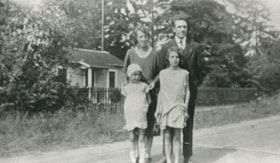
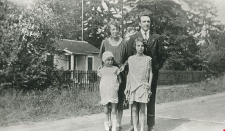
Brookes family home
- Repository
- City of Burnaby Archives
- Date
- [1920] (date of original), copied 1986
- Collection/Fonds
- Burnaby Historical Society fonds
- Description Level
- Item
- Physical Description
- 1 photograph : b&w ; 12.7 x 17.8 cm print
- Scope and Content
- Photograph of the Brookes family home at 441 12th Avenue (later renumbered 7979 12th Avenue), at the corner of 4th Street in East Burnaby. The Brookes family, headed by James Brookes, moved into this house in 1917. The house was later cut in two and moved to another part of the lot, becoming a gard…
Brookes family home, "Normanna"
- Repository
- City of Burnaby Archives
- Date
- 1927
- Collection/Fonds
- Burnaby Historical Society fonds
- Description Level
- Item
- Physical Description
- 1 photograph : b&w ; 12.7 x 17.8 cm print
- Scope and Content
- Photograph of "Normanna," the Brookes family residence. This new Brookes family home was built in 1927 on the same site as the original house at 441 12th Avenue (later renumbered 7979 12th Avenue). Eventually, this became Normanna Norwegian rest home. The original house was built by Burnaby's firs…
Brook family home
- Repository
- City of Burnaby Archives
- Date
- 1919
- Collection/Fonds
- Burnaby Historical Society fonds
- Description Level
- Item
- Physical Description
- 1 photograph : b&w ; 6.9 x 11.4 cm
- Scope and Content
- Photograph of the exterior of the Brook family home at 7979 12th Avenue, East Burnaby. This house later became the Normanna Rest Home, 7725 4th Street.
Brook family house
- Repository
- City of Burnaby Archives
- Date
- 1919
- Collection/Fonds
- Burnaby Historical Society fonds
- Description Level
- Item
- Physical Description
- 1 photograph : b&w ; 6.9 x 11.3 cm
- Scope and Content
- Photograph of the exterior of the Brook family home at 7979 12th Avenue, East Burnaby. This house later became the Normanna Rest Home, 7725 4th Street.
Burnaby's Operation Identification
- Repository
- City of Burnaby Archives
- Date
- 1976, published January 7, 1976
- Collection/Fonds
- Columbian Newspaper collection
- Description Level
- Item
- Physical Description
- 1 photograph : b&w ; 22.5 x 14.5 cm
- Scope and Content
- Photograph of municipal workers Bill Ramsay and Greg Finch putting up a sign in preparation for Burnaby's Operation Identification, which was "the largest single crime prevention policy of its kind in Canada" when "47 uniformed officers of the Burnaby detachment [joined] 47 Rotarians from the Burna…
- Repository
- City of Burnaby Archives
- Date
- 1976, published January 7, 1976
- Collection/Fonds
- Columbian Newspaper collection
- Physical Description
- 1 photograph : b&w ; 22.5 x 14.5 cm
- Description Level
- Item
- Record No.
- 480-225
- Access Restriction
- No restrictions
- Reproduction Restriction
- No restrictions
- Accession Number
- 2003-02
- Scope and Content
- Photograph of municipal workers Bill Ramsay and Greg Finch putting up a sign in preparation for Burnaby's Operation Identification, which was "the largest single crime prevention policy of its kind in Canada" when "47 uniformed officers of the Burnaby detachment [joined] 47 Rotarians from the Burnaby Kingsway Rotary Club and start door-to-door visits in 800 residences in South Burnaby. The teams [carried] electric engraving pens for marking all property susceptible to theft."
- Subjects
- Occupations - Civic Workers
- Public Services - Policing
- Names
- Royal Canadian Mounted Police
- Burnaby Kingsway Rotary Club
- Media Type
- Photograph
- Photographer
- King, Basil
- Notes
- Title based on contents of photograph
- Newspaper clipping attached to verso of photograph reads: "Burnaby detachment of the RCMP has embarked on the largest single crime prevention policy of its kind in Canada. "Operation Identification" officially kicks off tonight when 47 uniformed officers of the Burnaby detachment will join with 47 Rotarians from the Burnaby Kingsway Rotary Club and start door-to-door visits in 800 residences in South Burnaby. The teams will be carrying electric engraving pens for marking all property susceptible to theft. Municipal workers Bill Ramsay and Greg Finch are shown erecting one of the signs on Canada Way at 14th Avenue as "sidewalk superintendents" Sandra Finch and Corinne Williams look on."
- Geographic Access
- Canada Way
- 14th Avenue
- Historic Neighbourhood
- Edmonds (Historic Neighbourhood)
- Planning Study Area
- Edmonds Area
Less detail
Butler family
- Repository
- City of Burnaby Archives
- Date
- 1930 (date of original), copied 1986
- Collection/Fonds
- Burnaby Historical Society fonds
- Description Level
- Item
- Physical Description
- 1 photograph : b&w ; 12.7 x 17.8 cm print
- Scope and Content
- Photograph of (back, from left); (parents) Margaret and Edwin Butler; (front, from left) Gladys and Hazel Butler. The Butlers lived at 278 14th Avenue (later renumbered 8062 14th Avenue), East Burnaby.
Corner view of Love farmhouse
- Repository
- Burnaby Village Museum
- Date
- [between 1966 and 1970]
- Collection/Fonds
- Love family fonds
- Description Level
- Item
- Physical Description
- 1 photograph : col. ; 10 x 15 cm print
- Scope and Content
- Photograph of the exterior of the Love farmhouse taken at the corner of Fourteenth Avenue and Cumberland Street. The house is hidden behind large trees at it's orignal address of 7651 Cumberland Street (Address pre 1960: 1390 Cumberland Road). This photograph was taken while Elsie Hughes (nee Love)…
- Repository
- Burnaby Village Museum
- Collection/Fonds
- Love family fonds
- Series
- Love family photographs series
- Description Level
- Item
- Physical Description
- 1 photograph : col. ; 10 x 15 cm print
- Material Details
- Copy print was made from re-photographing an original colour slide
- Scope and Content
- Photograph of the exterior of the Love farmhouse taken at the corner of Fourteenth Avenue and Cumberland Street. The house is hidden behind large trees at it's orignal address of 7651 Cumberland Street (Address pre 1960: 1390 Cumberland Road). This photograph was taken while Elsie Hughes (nee Love), her husband John Hughes and son Brent Hughes lived in the house. Elsie is the daughter of Sarah (nee Love) and William Parker. Sarah and William purchased the house in 1928, shortly after the death of Sarah's father, Jesse Love. Sarah and William Parker lived in the house with their three children, Albert, Bill and Elsie. William Parker died in 1961 and Sarah continued to live in the house until 1966 before selling it to her daughter Elsie and son in law John Hughes. Elsie and John lived in the house with their son Brent until 1971.
- Subjects
- Buildings - Heritage
- Geographic Access
- 14th Avenue
- Cumberland Street
- Street Address
- 7651 Cumberland Street
- Accession Code
- BV019.3.5
- Access Restriction
- No restrictions
- Reproduction Restriction
- No known restrictions
- Date
- [between 1966 and 1970]
- Media Type
- Photograph
- Historic Neighbourhood
- East Burnaby (Historic Neighbourhood)
- Planning Study Area
- Cariboo-Armstrong Area
- Scan Resolution
- 600
- Scan Date
- 31-Jan-2019
- Scale
- 96
- Photographer
- Parker, Albert "Bert"
- Notes
- Title based on contents of photograph
- See also BV992.15.12
Less detail
Corner view of Love farmhouse
- Repository
- Burnaby Village Museum
- Date
- [between 1966 and 1970]
- Collection/Fonds
- Love family fonds
- Description Level
- Item
- Physical Description
- 1 photograph : col. ; 10 x 15 cm print
- Scope and Content
- Photograph of the exterior of the Love farmhouse taken at the corner of Fourteenth Avenue and Cumberland Street. The north side of the house and kitchen are in view with large trees covering the front of the house at it's orignal address of 7651 Cumberland Street (Address pre 1960: 1390 Cumberland …
- Repository
- Burnaby Village Museum
- Collection/Fonds
- Love family fonds
- Series
- Love family photographs series
- Description Level
- Item
- Physical Description
- 1 photograph : col. ; 10 x 15 cm print
- Material Details
- Copy print was made from re-photographing an original colour slide
- Scope and Content
- Photograph of the exterior of the Love farmhouse taken at the corner of Fourteenth Avenue and Cumberland Street. The north side of the house and kitchen are in view with large trees covering the front of the house at it's orignal address of 7651 Cumberland Street (Address pre 1960: 1390 Cumberland Road). This photograph was taken while Elsie Hughes (nee Love), her husband John Hughes and son Brent Hughes lived in the house. Elsie is the daughter of Sarah (nee Love) and William Parker. Sarah and William purchased the house in 1928, shortly after the death of Sarah's father, Jesse Love. Sarah and William Parker lived in the house with their three children, Albert, Bill and Elsie. William Parker died in 1961 and Sarah continued to live in the house until 1966 before selling it to her daughter Elsie and son in law John Hughes. Elsie and John lived in the house with their son Brent until 1971.
- Subjects
- Buildings - Heritage
- Geographic Access
- 14th Avenue
- Cumberland Street
- Street Address
- 7651 Cumberland Street
- Accession Code
- BV019.3.6
- Access Restriction
- No restrictions
- Reproduction Restriction
- No known restrictions
- Date
- [between 1966 and 1970]
- Media Type
- Photograph
- Historic Neighbourhood
- East Burnaby (Historic Neighbourhood)
- Planning Study Area
- Cariboo-Armstrong Area
- Scan Resolution
- 600
- Scan Date
- 31-Jan-2019
- Scale
- 96
- Photographer
- Parker, Albert "Bert"
- Notes
- Title based on contents of photograph
- See also BV992.15.12
Less detail
Edwin Butler
- Repository
- City of Burnaby Archives
- Date
- [1925] (date of original), copied 1986
- Collection/Fonds
- Burnaby Historical Society fonds
- Description Level
- Item
- Physical Description
- 1 photograph : b&w ; 12.7 x 17.8 cm print
- Scope and Content
- Photograph of Edwin Butler with pet dog, Bing, and pet cat, Boots. Edwin was married to Margaret Butler. They first settled in Burnaby at 278 14th Avenue (later renumbered 8062 14th Avenue), East Burnaby in 1924.
Exterior of Love farmhouse
- Repository
- Burnaby Village Museum
- Date
- 1971 (date of original), copied 1990
- Collection/Fonds
- Love family fonds
- Description Level
- Item
- Physical Description
- 1 photograph : col. ; 10 x 15 cm print
- Scope and Content
- Photograph of the exterior of the Love farmhouse taken from the corner of Fourteenth Avenue and Cumberland Street while Elsie (nee Love) Hughes, her husband John and son Brent lived in the house. The house was located at 7651 Cumberland Street (Address pre 1960: 1390 Cumberland Road) and was moved …
Floden House auction
- Repository
- City of Burnaby Archives
- Date
- [2003]
- Collection/Fonds
- Burnaby NewsLeader photograph collection
- Description Level
- Item
- Physical Description
- 1 photograph (tiff) : col.
- Scope and Content
- Photograph of Helen Krenzler, City of Burnaby property negotiator, standing in front of the heritage home Floden House and a sign that reads: "City of Burnaby / For Sale by Public Tender / Viewing by Appointment / Minimum Bid Price $295,000.00". Krenzler holds a banker's box that contains an antiqu…
- Repository
- City of Burnaby Archives
- Date
- [2003]
- Collection/Fonds
- Burnaby NewsLeader photograph collection
- Physical Description
- 1 photograph (tiff) : col.
- Description Level
- Item
- Record No.
- 535-1827
- Access Restriction
- No restrictions
- Reproduction Restriction
- No restrictions
- Accession Number
- 2018-12
- Scope and Content
- Photograph of Helen Krenzler, City of Burnaby property negotiator, standing in front of the heritage home Floden House and a sign that reads: "City of Burnaby / For Sale by Public Tender / Viewing by Appointment / Minimum Bid Price $295,000.00". Krenzler holds a banker's box that contains an antique light fixture.
- Subjects
- Buildings - Residential - Houses
- Buildings - Heritage
- Occupations - Civic Workers
- Media Type
- Photograph
- Photographer
- Bartel, Mario
- Notes
- Title based on caption
- Collected by editorial for use in a January 2003 issue of the Burnaby NewsLeader
- Caption from metadata: "Helen Krenzler, the City of Burnaby's property negotiator, returns some antique light fixtures to the old Floden House, in preparation for an open house for prospective buyers. The City is auctioning the heritage home after moving it to a new location last year."
- Geographic Access
- 4th Street
- Street Address
- 7244 4th Street
- Historic Neighbourhood
- East Burnaby (Historic Neighbourhood)
- Planning Study Area
- Edmonds Area
Less detail
Floden House relocation
- Repository
- City of Burnaby Archives
- Date
- [2001]
- Collection/Fonds
- Burnaby NewsLeader photograph collection
- Description Level
- Item
- Physical Description
- 1 photograph (tiff) : col.
- Scope and Content
- Photograph of the relocation of Floden House, a heritage home built in 1929. A man in a hard hat stands in the foreground, directing the flatbed truck that is carrying the two-storey location to its new location on 4th Street.
- Repository
- City of Burnaby Archives
- Date
- [2001]
- Collection/Fonds
- Burnaby NewsLeader photograph collection
- Physical Description
- 1 photograph (tiff) : col.
- Description Level
- Item
- Record No.
- 535-1628
- Access Restriction
- No restrictions
- Reproduction Restriction
- No restrictions
- Accession Number
- 2018-12
- Scope and Content
- Photograph of the relocation of Floden House, a heritage home built in 1929. A man in a hard hat stands in the foreground, directing the flatbed truck that is carrying the two-storey location to its new location on 4th Street.
- Subjects
- Buildings - Heritage
- Buildings - Residential - Houses
- Media Type
- Photograph
- Photographer
- Bartel, Mario
- Notes
- Title based on caption
- Collected by editorial for use in a February 2001 issue of the Burnaby NewsLeader
- Caption from metadata: "Garry Hands, of Nickel Brothers, directs the delicate task of moving the Floden house along 4th Street in Burnaby to its new resting place further west on the street."
- Geographic Access
- 4th Street
- Street Address
- 7244 4th Street
- Historic Neighbourhood
- East Burnaby (Historic Neighbourhood)
- Planning Study Area
- Edmonds Area
Less detail
James Brooke's house
- Repository
- Burnaby Village Museum
- Date
- [1925]
- Collection/Fonds
- Burnaby Village Museum Photograph collection
- Description Level
- Item
- Physical Description
- 1 photograph : b&w ; 6.9 x 11.5 cm
- Scope and Content
- Photograph of a two storey house with a basement built on a large lawn. There are flower beds on the lawn and a fence around the backyard. A neighboring house and the woods are visible in the background. According to the donor form, the photograph depicts James Brooke's house on 12th Avenue in Bu…
- Repository
- Burnaby Village Museum
- Collection/Fonds
- Burnaby Village Museum Photograph collection
- Description Level
- Item
- Physical Description
- 1 photograph : b&w ; 6.9 x 11.5 cm
- Scope and Content
- Photograph of a two storey house with a basement built on a large lawn. There are flower beds on the lawn and a fence around the backyard. A neighboring house and the woods are visible in the background. According to the donor form, the photograph depicts James Brooke's house on 12th Avenue in Burnaby, built by G. Moxham and Company. At the time of the donation, the house was owned by Normanna Rest Home. "
- Subjects
- Buildings - Residential - Houses
- Names
- Normanna Rest Home
- Geographic Access
- 4th Street
- Street Address
- 7725 4th Street
- Accession Code
- HV984.56.1
- Access Restriction
- No restrictions
- Reproduction Restriction
- No known restrictions
- Date
- [1925]
- Media Type
- Photograph
- Historic Neighbourhood
- East Burnaby (Historic Neighbourhood)
- Planning Study Area
- Second Street Area
- Scan Resolution
- 600
- Scan Date
- 2023-11-07
- Notes
- Title based on contents of photograph
- The annotation on verso of photo reads: "Home of James Brookes / (Normanna) now. / Built by G. Moxham & Co. / 1944 Sixth St. Burnaby. / built in early 20's - '22-'24?" Stamped on the back of the photo: "100.
Less detail
Jolly Neighbours Club
- Repository
- City of Burnaby Archives
- Date
- [1925] (date of original), copied 1986
- Collection/Fonds
- Burnaby Historical Society fonds
- Description Level
- Item
- Physical Description
- 1 photograph : b&w ; 12.7 x 17.8 cm print
- Scope and Content
- Photograph of members of the Jolly Neighbours Club founded by Margaret Butler, 14th Avenue, East Burnaby. Identified are: (Front row, left to right) Mrs. Wray, Bill (a Wray grandchild), Mrs. Hullatt, Jenny (another Wray grandchild), and Mrs. Swanson. (2nd row, left to right) Mrs. Cottam, and Mrs.…
- Repository
- City of Burnaby Archives
- Date
- [1925] (date of original), copied 1986
- Collection/Fonds
- Burnaby Historical Society fonds
- Series
- Community Archives Collection series
- Subseries
- Pioneer Tales subseries
- Physical Description
- 1 photograph : b&w ; 12.7 x 17.8 cm print
- Description Level
- Item
- Record No.
- 204-208
- Access Restriction
- No restrictions
- Reproduction Restriction
- No known restrictions
- Accession Number
- BHS1988-03
- Scope and Content
- Photograph of members of the Jolly Neighbours Club founded by Margaret Butler, 14th Avenue, East Burnaby. Identified are: (Front row, left to right) Mrs. Wray, Bill (a Wray grandchild), Mrs. Hullatt, Jenny (another Wray grandchild), and Mrs. Swanson. (2nd row, left to right) Mrs. Cottam, and Mrs. Hales. Mrs. Butler is in the back row, 4th from left.
- Subjects
- Organizations - Womens' Societies and Clubs
- Names
- Butler, Margaret
- Media Type
- Photograph
- Notes
- Title based on contents of photograph
- Geographic Access
- 14th Avenue
- Historic Neighbourhood
- East Burnaby (Historic Neighbourhood)
Less detail
Jon Raay on 18th Avenue
- Repository
- City of Burnaby Archives
- Date
- [2002]
- Collection/Fonds
- Burnaby NewsLeader photograph collection
- Description Level
- Item
- Physical Description
- 1 photograph (tiff) : col.
- Scope and Content
- Photograph of Jon Raay posing at the corner of 18th Avenue and 4th Street in front of residential homes, where a large tree was cut down at the former Floden House property.
- Repository
- City of Burnaby Archives
- Date
- [2002]
- Collection/Fonds
- Burnaby NewsLeader photograph collection
- Physical Description
- 1 photograph (tiff) : col.
- Description Level
- Item
- Record No.
- 535-2813
- Access Restriction
- No restrictions
- Reproduction Restriction
- No restrictions
- Accession Number
- 2018-12
- Scope and Content
- Photograph of Jon Raay posing at the corner of 18th Avenue and 4th Street in front of residential homes, where a large tree was cut down at the former Floden House property.
- Subjects
- Buildings - Residential - Houses
- Plants - Trees
- Media Type
- Photograph
- Photographer
- Bartel, Mario
- Notes
- Title based on caption
- Collected by editorial for use in an October 2002 issue of the Burnaby NewsLeader
- Caption from metadata: "Jon Raay can only see sky where once a big old oak tree stood, at the corner of the old Flouden Farm property at 18th Ave. and 4th St., in Burnaby. The tree was chopped down last weekend by the property's new owners, despite a covenant with the city to preserve the tree."
- Geographic Access
- 18th Avenue
- 4th Street
- Historic Neighbourhood
- East Burnaby (Historic Neighbourhood)
- Planning Study Area
- Edmonds Area
Less detail


![14th Avenue neighbourhood friends, [1925] (date of original), copied 1986 thumbnail](/media/hpo/_Data/_Archives_Images/_Unrestricted/204/204-205.jpg?width=280)
![14th Avenue neighbourhood friends, [1925] (date of original), copied 1986 thumbnail](/media/hpo/_Data/_Archives_Images/_Unrestricted/204/204-205.jpg)
![Brookes family home, [1920] (date of original), copied 1986 thumbnail](/media/hpo/_Data/_Archives_Images/_Unrestricted/204/204-102.jpg?width=280)
![Brookes family home, [1920] (date of original), copied 1986 thumbnail](/media/hpo/_Data/_Archives_Images/_Unrestricted/204/204-102.jpg)


![Corner view of Love farmhouse, [between 1966 and 1970] thumbnail](/media/hpo/_Data/_BVM_Images/2019/2019_0003_0005_001.jpg?width=280)
![Corner view of Love farmhouse, [between 1966 and 1970] thumbnail](/media/hpo/_Data/_BVM_Images/2019/2019_0003_0005_001.jpg)
![Corner view of Love farmhouse, [between 1966 and 1970] thumbnail](/media/hpo/_Data/_BVM_Images/2019/2019_0003_0006_001.jpg?width=280)
![Corner view of Love farmhouse, [between 1966 and 1970] thumbnail](/media/hpo/_Data/_BVM_Images/2019/2019_0003_0006_001.jpg)
![Edwin Butler, [1925] (date of original), copied 1986 thumbnail](/media/hpo/_Data/_Archives_Images/_Unrestricted/204/204-204.jpg?width=280)
![Edwin Butler, [1925] (date of original), copied 1986 thumbnail](/media/hpo/_Data/_Archives_Images/_Unrestricted/204/204-204.jpg)


![Floden House auction, [2003] thumbnail](/media/hpo/_Data/_Archives_Images/_Unrestricted/535/535-1827.jpg?width=280)
![Floden House auction, [2003] thumbnail](/media/hpo/_Data/_Archives_Images/_Unrestricted/535/535-1827.jpg)
![Floden House relocation, [2001] thumbnail](/media/hpo/_Data/_Archives_Images/_Unrestricted/535/535-1628.jpg?width=280)
![Floden House relocation, [2001] thumbnail](/media/hpo/_Data/_Archives_Images/_Unrestricted/535/535-1628.jpg)
![House fire, [1999] thumbnail](/media/hpo/_Data/_Archives_Images/_Unrestricted/535/535-3385.jpg?width=280)
![House fire, [1999] thumbnail](/media/hpo/_Data/_Archives_Images/_Unrestricted/535/535-3385.jpg)
![James Brooke's house, [1925] thumbnail](/media/hpo/_Data/_BVM_Images/1984/1984_0056_0001_001.jpg?width=280)
![James Brooke's house, [1925] thumbnail](/media/hpo/_Data/_BVM_Images/1984/1984_0056_0001_001.jpg)
![Jolly Neighbours Club, [1925] (date of original), copied 1986 thumbnail](/media/hpo/_Data/_Archives_Images/_Unrestricted/204/204-208.jpg?width=280)
![Jolly Neighbours Club, [1925] (date of original), copied 1986 thumbnail](/media/hpo/_Data/_Archives_Images/_Unrestricted/204/204-208.jpg)
![Jon Raay on 18th Avenue, [2002] thumbnail](/media/hpo/_Data/_Archives_Images/_Unrestricted/535/535-2813.jpg?width=280)
![Jon Raay on 18th Avenue, [2002] thumbnail](/media/hpo/_Data/_Archives_Images/_Unrestricted/535/535-2813.jpg)