East Burnaby Neighbourhood
https://search.heritageburnaby.ca/link/landmark712
- Repository
- Burnaby Heritage Planning
- Associated Dates
- 1925-1954
- Heritage Value
- After a lull in construction during the World War I period, East Burnaby Neighbourhood's growth resumed during the 1920s when many homes and businesses were constructed. The post-World War Two period also saw rapid construction and the creation of new housing developments in response to a population boom. The neighbourhood remained a primarily single-family residential area.
- Historic Neighbourhood
- Edmonds (Historic Neighbourhood)
- Planning Study Area
- Stride Avenue Area
Images


Edmonds Neighbourhood
https://search.heritageburnaby.ca/link/landmark704
- Repository
- Burnaby Heritage Planning
- Associated Dates
- 1925-1954
- Heritage Value
- The historic growth of Edmonds as a neighbourhood was based on its strategic location on the early interurban line between Vancouver and New Westminster. Even by 1980 when a survey of the residential neighbourhoods was conducted, a full 25% of homes in the area predated 1930. The 1950s was a period of strong housing development, with both single-family and multi-family units being constructed. Although Burnaby's City Hall was moved from Kingsway and Edmonds in the early 1950s, Edmonds remained an important centre in the community.
- Historic Neighbourhood
- Edmonds (Historic Neighbourhood)
- Planning Study Area
- Stride Avenue Area
Images


England House
https://search.heritageburnaby.ca/link/landmark501
- Repository
- Burnaby Heritage Planning
- Description
- The Mary England Residence is a one and one-half storey, wood-frame, Period Revival cottage with a steeply pitched, cross-gabled roof. Situated on Griffiths Drive within the Edmonds neighbourhood of Burnaby, the Mary England Residence has an original attached garage.
- Associated Dates
- 1930
- Formal Recognition
- Community Heritage Register
- Other Names
- Mary England Residence
- Street View URL
- Google Maps Street View
- Repository
- Burnaby Heritage Planning
- Other Names
- Mary England Residence
- Geographic Access
- Griffiths Drive
- Associated Dates
- 1930
- Formal Recognition
- Community Heritage Register
- Enactment Type
- Council Resolution
- Enactment Date
- 26/05/2003
- Description
- The Mary England Residence is a one and one-half storey, wood-frame, Period Revival cottage with a steeply pitched, cross-gabled roof. Situated on Griffiths Drive within the Edmonds neighbourhood of Burnaby, the Mary England Residence has an original attached garage.
- Heritage Value
- The Mary England Residence, built in 1930, is valued as a representation of the period revival styles that were popular in the era between the two World Wars. At this time, it was considered the height of fashion for a house to reflect historical styles, even when combined in an eclectic manner, that expressed a domestic ideal of cozy traditionalism. The Mary England Residence is an exuberant example of this trend. Half-timbering, multi-paned and leaded casement windows and a steeply pitched, cross-gabled roof impart a storybook cottage charm. Its first owner, Mary England, was employed for several years as stenographer at the old Burnaby Municipal Hall. An original attached garage is evidence of the growing presence of automobiles in domestic life of the 1930s. Additionally, the Mary England Residence is a testament to the continued suburban growth of the Edmonds neighbourhood. During the Edwardian era, the area experienced a housing boom. Its proximity to New Westminster, coupled with its regional transportation links, made it an attractive area for middle-class residences. Despite the economic recession of the 1930s, the Edmonds area continued to develop with modest but handsome housing.
- Defining Elements
- Key elements that define the heritage character of the Mary England Residence: - location, in the Edmonds neighbourhood of East Burnaby - residential form, scale and massing as expressed by its one and one-half storey height with full basement, rectangular plan and steeply pitched cross-gabled roof - Period Revival elements such as rough-cast stucco, half-timbering, minimal eave overhangs, arched entry with glazed wooden front door, and arched-top feature window - mixture of windows including: double-hung, multi-paned wooden sash windows in double assembly; 6-over-1 double-hung wooden sash windows in multiple assembly; multi-paned casement windows; and straight-leaded feature windows - external parged chimney and two internal chimneys - attached front-gabled garage - associated landscape features including mature deciduous trees and fruit trees
- Historic Neighbourhood
- Edmonds (Historic Neighbourhood)
- Planning Study Area
- Stride Avenue Area
- Function
- Primary Historic--Single Dwelling
- Primary Current--Single Dwelling
- Community
- Edmonds
- Cadastral Identifier
- P.I.D.011-115-424
- Boundaries
- The Mary England Residence is comprised of a single residential lot located at 7276 Griffiths Drive, Burnaby.
- Area
- 1404.26
- Contributing Resource
- Building
- Ownership
- Public (local)
- Documentation
- City of Burnaby Planning and Building Department, Heritage Site Files
- Street Address
- 7276 Griffiths Drive
- Street View URL
- Google Maps Street View
Images


Stride Avenue Neighbourhood
https://search.heritageburnaby.ca/link/landmark845
- Repository
- Burnaby Heritage Planning
- Associated Dates
- 1955-2008
- Heritage Value
- The interurban link between New Westminster and Vancouver stimulated the early settlement of Stride Avenue. Infilling of the area took place in the early 1950s and the pace of development had slowed considerably by 1970. Duplexes became a popular feature in the decade between 1970 and 1980 and in the late 1980s, the neighbourhood was incorporated into the Edmonds Town Centre South plan.
- Historic Neighbourhood
- Edmonds (Historic Neighbourhood)
- Planning Study Area
- Stride Avenue Area
Images

6745 Station Hill Crt
https://search.heritageburnaby.ca/link/archivedescription94204
- Repository
- City of Burnaby Archives
- Date
- September 1993
- Collection/Fonds
- Grover, Elliott & Co. Ltd. fonds
- Description Level
- File
- Physical Description
- 21 photographs : col. negatives ; 35 mm
- Scope and Content
- Photographs of an undeveloped property located at 6745 Station Hill Court.
- Repository
- City of Burnaby Archives
- Date
- September 1993
- Collection/Fonds
- Grover, Elliott & Co. Ltd. fonds
- Physical Description
- 21 photographs : col. negatives ; 35 mm
- Description Level
- File
- Record No.
- 622-079
- Access Restriction
- No restrictions
- Reproduction Restriction
- No restrictions
- Accession Number
- 2017-39
- Scope and Content
- Photographs of an undeveloped property located at 6745 Station Hill Court.
- Subjects
- Geographic Features - Roads
- Media Type
- Photograph
- Notes
- Transcribed title
- Title transcribed from envelope photographs were originally housed in
- File no. 93-463-B
- Photographer identified as "K.H."
- Geographic Access
- Station Hill Court
- Street Address
- 6745 Station Hill Court
- Historic Neighbourhood
- Edmonds (Historic Neighbourhood)
- Planning Study Area
- Stride Avenue Area
7026 Kingsway
https://search.heritageburnaby.ca/link/archivedescription94304
- Repository
- City of Burnaby Archives
- Date
- January 1994
- Collection/Fonds
- Grover, Elliott & Co. Ltd. fonds
- Description Level
- File
- Physical Description
- 19 photographs : col. negatives ; 35 mm
- Scope and Content
- Photographs of commercial and undeveloped properties located in the 7100 block of Kingsway, including Middlegate Honda, with mid-rise towers visible in the background.
- Repository
- City of Burnaby Archives
- Date
- January 1994
- Collection/Fonds
- Grover, Elliott & Co. Ltd. fonds
- Physical Description
- 19 photographs : col. negatives ; 35 mm
- Description Level
- File
- Record No.
- 622-089
- Access Restriction
- No restrictions
- Reproduction Restriction
- No restrictions
- Accession Number
- 2017-39
- Scope and Content
- Photographs of commercial and undeveloped properties located in the 7100 block of Kingsway, including Middlegate Honda, with mid-rise towers visible in the background.
- Media Type
- Photograph
- Notes
- Transcribed title
- Title transcribed from envelope photographs were originally housed in
- File no. 94-028-B
- Photographer identified as "L.D."
- Geographic Access
- Kingsway
- Historic Neighbourhood
- Edmonds (Historic Neighbourhood)
- Planning Study Area
- Stride Avenue Area
7026 Kingsway, Burnaby
https://search.heritageburnaby.ca/link/archivedescription93819
- Repository
- City of Burnaby Archives
- Date
- January 1993
- Collection/Fonds
- Grover, Elliott & Co. Ltd. fonds
- Description Level
- File
- Physical Description
- 32 photographs : col. negatives ; 35 mm
- Scope and Content
- Photographs of an undeveloped property located at 7026 Kingsway - an address that no longer exists.
- Repository
- City of Burnaby Archives
- Date
- January 1993
- Collection/Fonds
- Grover, Elliott & Co. Ltd. fonds
- Physical Description
- 32 photographs : col. negatives ; 35 mm
- Description Level
- File
- Record No.
- 622-062
- Access Restriction
- No restrictions
- Reproduction Restriction
- No restrictions
- Accession Number
- 2017-39
- Scope and Content
- Photographs of an undeveloped property located at 7026 Kingsway - an address that no longer exists.
- Subjects
- Geographic Features - Roads
- Media Type
- Photograph
- Notes
- Transcribed title
- Title transcribed from envelope photographs were originally housed in
- File no. 93-013-R
- Sticky note adhered to 622-062-4 print reads: "1 / 7026 Kingsway Burnaby, B.C."
- Sticky note adhere to 622-062-8 print reads: "3 / View west along Kingsway"
- Sticky note adhered to 622-062-12 print reads: "5 / View northwest across the site from Beresford Street"
- Sticky note adhered to 622-062-16 print reads: "4 . View [illegible] along to Beresford Ave. right of way at the southeast corner of the [illegible] site"
- Sticky note adhered to 622-062-20 print reads: "6 / View east along Beresford Street at Greenford Avenue"
- Sticky note adhered to 622-062-24 print reads: "7 / View north along Greenford Avenue"
- Sticky note adhered to 622-062-28 print reads: "8 / View northeast across the site from Grenford Avenue"
- Sticky note adhered to 622-062-32 print reads: "2 / View east along Kingsway past subject site"
- Photographer identified as "D.E."
- Geographic Access
- Kingsway
- Historic Neighbourhood
- Edmonds (Historic Neighbourhood)
- Planning Study Area
- Stride Avenue Area
7119-7125 17th Ave and 7016-7124 18th Ave
https://search.heritageburnaby.ca/link/archivedescription94299
- Repository
- City of Burnaby Archives
- Date
- December 1993
- Collection/Fonds
- Grover, Elliott & Co. Ltd. fonds
- Description Level
- File
- Physical Description
- 12 photographs : col. negatives ; 35 mm
- Scope and Content
- Photographs of two single-family homes and their surrounding properties.
- Repository
- City of Burnaby Archives
- Date
- December 1993
- Collection/Fonds
- Grover, Elliott & Co. Ltd. fonds
- Physical Description
- 12 photographs : col. negatives ; 35 mm
- Description Level
- File
- Record No.
- 622-084
- Access Restriction
- No restrictions
- Reproduction Restriction
- No restrictions
- Accession Number
- 2017-39
- Scope and Content
- Photographs of two single-family homes and their surrounding properties.
- Subjects
- Buildings - Residential - Houses
- Media Type
- Photograph
- Notes
- Transcribed title
- Title transcribed from envelope photographs were originally housed in
- File no. 93-515-B
- Photographer identified as "J.C."
- Geographic Access
- 17th Avenue
- 18th Avenue
- Historic Neighbourhood
- Edmonds (Historic Neighbourhood)
- Planning Study Area
- Stride Avenue Area
7128-7143 Edmonds and 7131-7143 18th Ave
https://search.heritageburnaby.ca/link/archivedescription93760
- Repository
- City of Burnaby Archives
- Date
- May 11, 1992
- Collection/Fonds
- Grover, Elliott & Co. Ltd. fonds
- Description Level
- Item
- Physical Description
- 1 photograph : col. ; 10 cm x 15 cm
- Scope and Content
- Photographs of three single-storey houses located at 7131-7143 18th Avenue (addresses that no longer exist) with a high-rise condominium in the background. 7131-7143 18th Avenue are now 7139 18th Avenue. The condominium in the distance is located at 7108 Edmonds Avenue.
- Repository
- City of Burnaby Archives
- Date
- May 11, 1992
- Collection/Fonds
- Grover, Elliott & Co. Ltd. fonds
- Physical Description
- 1 photograph : col. ; 10 cm x 15 cm
- Description Level
- Item
- Record No.
- 622-045
- Access Restriction
- No restrictions
- Reproduction Restriction
- No restrictions
- Accession Number
- 2017-39
- Scope and Content
- Photographs of three single-storey houses located at 7131-7143 18th Avenue (addresses that no longer exist) with a high-rise condominium in the background. 7131-7143 18th Avenue are now 7139 18th Avenue. The condominium in the distance is located at 7108 Edmonds Avenue.
- Subjects
- Buildings - Residential - Houses
- Media Type
- Photograph
- Photographer
- Young, Richard
- Notes
- Transcribed title
- Title transcribed from envelope photograph was originally housed in
- File no. 92-190-B
- Geographic Access
- 18th Avenue
- Edmonds Street
- Street Address
- 7139 18th Avenue
- 7108 Edmonds Avenue
- Historic Neighbourhood
- Edmonds (Historic Neighbourhood)
- Planning Study Area
- Stride Avenue Area
7143 - 18th Ave
https://search.heritageburnaby.ca/link/archivedescription93758
- Repository
- City of Burnaby Archives
- Date
- 1992
- Collection/Fonds
- Grover, Elliott & Co. Ltd. fonds
- Description Level
- Item
- Physical Description
- 1 photograph : col. ; 10 cm x 15 cm
- Scope and Content
- Photograph of a white, single-storey house located at 7143 18th Avenue - an address that no longer exists. The current address of the property is 7139 18th Avenue.
- Repository
- City of Burnaby Archives
- Date
- 1992
- Collection/Fonds
- Grover, Elliott & Co. Ltd. fonds
- Physical Description
- 1 photograph : col. ; 10 cm x 15 cm
- Description Level
- Item
- Record No.
- 622-043
- Access Restriction
- No restrictions
- Reproduction Restriction
- No restrictions
- Accession Number
- 2017-39
- Scope and Content
- Photograph of a white, single-storey house located at 7143 18th Avenue - an address that no longer exists. The current address of the property is 7139 18th Avenue.
- Subjects
- Buildings - Residential - Houses
- Media Type
- Photograph
- Notes
- Transcribed title
- Title transcribed from envelope photographs were originally housed in
- File no. 92-188-B
- Geographic Access
- 18th Avenue
- Street Address
- 7139 18th Avenue
- Historic Neighbourhood
- Edmonds (Historic Neighbourhood)
- Planning Study Area
- Stride Avenue Area
7183-7195 17th Ave and 7182-7194 18th Ave Burnaby
https://search.heritageburnaby.ca/link/archivedescription93893
- Repository
- City of Burnaby Archives
- Date
- June 1993
- Collection/Fonds
- Grover, Elliott & Co. Ltd. fonds
- Description Level
- File
- Physical Description
- 25 photographs : col. negatives ; 35 mm
- Scope and Content
- Photographs of a townhouse complex and surrounding area located at 7183-7195 17th Avenue and 7182-7194 18th Avenue - addresses that no longer exist.
- Repository
- City of Burnaby Archives
- Date
- June 1993
- Collection/Fonds
- Grover, Elliott & Co. Ltd. fonds
- Physical Description
- 25 photographs : col. negatives ; 35 mm
- Description Level
- File
- Record No.
- 622-076
- Access Restriction
- No restrictions
- Reproduction Restriction
- No restrictions
- Accession Number
- 2017-39
- Scope and Content
- Photographs of a townhouse complex and surrounding area located at 7183-7195 17th Avenue and 7182-7194 18th Avenue - addresses that no longer exist.
- Media Type
- Photograph
- Notes
- Transcribed title
- Title transcribed from envelope photographs were originally housed in
- File no. 93-291-B
- Photographer identified as "J.C."
- Geographic Access
- 17th Avenue
- 18th Avenue
- Historic Neighbourhood
- Edmonds (Historic Neighbourhood)
- Planning Study Area
- Stride Avenue Area
7641-51 Kingsway Ave
https://search.heritageburnaby.ca/link/archivedescription94346
- Repository
- City of Burnaby Archives
- Date
- August 1995
- Collection/Fonds
- Grover, Elliott & Co. Ltd. fonds
- Description Level
- File
- Physical Description
- 25 photographs : col. negatives ; 35 mm
- Scope and Content
- Photographs of a two-storey commercial building located on the 7600 block of Kingsway and the Burnaby Hotel on the opposite side of the street.
- Repository
- City of Burnaby Archives
- Date
- August 1995
- Collection/Fonds
- Grover, Elliott & Co. Ltd. fonds
- Physical Description
- 25 photographs : col. negatives ; 35 mm
- Description Level
- File
- Record No.
- 622-131
- Access Restriction
- No restrictions
- Reproduction Restriction
- No restrictions
- Accession Number
- 2017-39
- Scope and Content
- Photographs of a two-storey commercial building located on the 7600 block of Kingsway and the Burnaby Hotel on the opposite side of the street.
- Media Type
- Photograph
- Notes
- Transcribed title
- Title transcribed from envelope photographs were originally housed in
- File no. 95-286-B
- Photographer identified as "L.D."
- Geographic Access
- Kingsway
- Historic Neighbourhood
- Edmonds (Historic Neighbourhood)
- Planning Study Area
- Stride Avenue Area
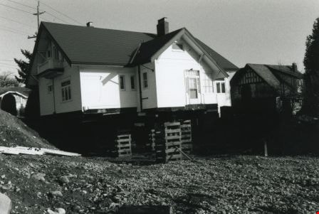
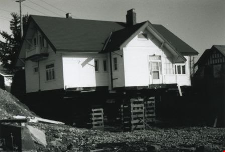
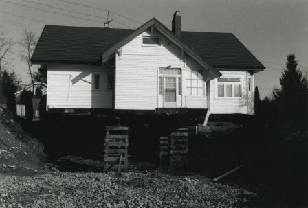
Back and side of the Britton house
https://search.heritageburnaby.ca/link/archivedescription36581
- Repository
- City of Burnaby Archives
- Date
- November 1992
- Collection/Fonds
- Burnaby Historical Society fonds
- Description Level
- Item
- Physical Description
- 1 photograph : b&w ; 10 x 15 cm print
- Scope and Content
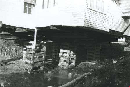
- Photograph of back and side of the Britton house taken from ground level during the Britton house moving project, while the house was up on stilts.
- Repository
- City of Burnaby Archives
- Date
- November 1992
- Collection/Fonds
- Burnaby Historical Society fonds
- Subseries
- Britton family subseries
- Physical Description
- 1 photograph : b&w ; 10 x 15 cm print
- Description Level
- Item
- Record No.
- 303-003
- Access Restriction
- No restrictions
- Reproduction Restriction
- Reproduce for fair dealing purposes only
- Accession Number
- BHS1992-44
- Scope and Content
- Photograph of back and side of the Britton house taken from ground level during the Britton house moving project, while the house was up on stilts.
- Subjects
- Buildings - Residential - Houses
- Media Type
- Photograph
- Notes
- Title based on contents of photograph
- 1 b&w negative accompanying
- Geographic Access
- Kingsway
- Street Address
- 7505 Kingsway
- Historic Neighbourhood
- Edmonds (Historic Neighbourhood)
- Planning Study Area
- Stride Avenue Area
Images
Back and side of the Britton house
https://search.heritageburnaby.ca/link/archivedescription36589
- Repository
- City of Burnaby Archives
- Date
- November 1992
- Collection/Fonds
- Burnaby Historical Society fonds
- Description Level
- Item
- Physical Description
- 1 photograph : b&w ; 10 x 15 cm print
- Scope and Content
- Photograph of back and side of the Britton house taken from ground level during the Britton house moving project, while the house was up on stilts.
- Repository
- City of Burnaby Archives
- Date
- November 1992
- Collection/Fonds
- Burnaby Historical Society fonds
- Subseries
- Britton family subseries
- Physical Description
- 1 photograph : b&w ; 10 x 15 cm print
- Description Level
- Item
- Record No.
- 303-011
- Access Restriction
- No restrictions
- Reproduction Restriction
- Reproduce for fair dealing purposes only
- Accession Number
- BHS1992-44
- Scope and Content
- Photograph of back and side of the Britton house taken from ground level during the Britton house moving project, while the house was up on stilts.
- Subjects
- Buildings - Residential - Houses
- Media Type
- Photograph
- Notes
- Title based on contents of photograph
- 1 b&w negative accompanying
- Geographic Access
- Kingsway
- Street Address
- 7505 Kingsway
- Historic Neighbourhood
- Edmonds (Historic Neighbourhood)
- Planning Study Area
- Stride Avenue Area
Images
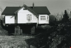
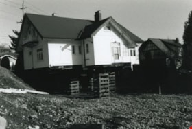
Back of the Britton house
https://search.heritageburnaby.ca/link/archivedescription36585
- Repository
- City of Burnaby Archives
- Date
- November 1992
- Collection/Fonds
- Burnaby Historical Society fonds
- Description Level
- Item
- Physical Description
- 1 photograph : b&w ; 10 x 15 cm print
- Scope and Content
- Photograph of the back of the Britton house up on stilts and its surrounding yard during the Britton house moving project.
- Repository
- City of Burnaby Archives
- Date
- November 1992
- Collection/Fonds
- Burnaby Historical Society fonds
- Subseries
- Britton family subseries
- Physical Description
- 1 photograph : b&w ; 10 x 15 cm print
- Description Level
- Item
- Record No.
- 303-007
- Access Restriction
- No restrictions
- Reproduction Restriction
- Reproduce for fair dealing purposes only
- Accession Number
- BHS1992-44
- Scope and Content
- Photograph of the back of the Britton house up on stilts and its surrounding yard during the Britton house moving project.
- Subjects
- Buildings - Residential - Houses
- Media Type
- Photograph
- Notes
- Title based on contents of photograph
- 1 b&w negative accompanying
- Geographic Access
- Kingsway
- Street Address
- 7505 Kingsway
- Historic Neighbourhood
- Edmonds (Historic Neighbourhood)
- Planning Study Area
- Stride Avenue Area
Images
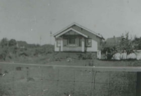
Banks family home
https://search.heritageburnaby.ca/link/archivedescription37498
- Repository
- City of Burnaby Archives
- Date
- 1933 (date of original), copied 1991
- Collection/Fonds
- Burnaby Historical Society fonds
- Description Level
- Item
- Physical Description
- 1 photograph : b&w ; 2.7 x 4.0 cm print on contact sheet 20.2 x 25.3 cm
- Scope and Content
- Photograph of the Banks family home at the back of the Burnaby Garage at 1812 Britton Street and Kingsway (later renumbered 7383 Britton Street).
- Repository
- City of Burnaby Archives
- Date
- 1933 (date of original), copied 1991
- Collection/Fonds
- Burnaby Historical Society fonds
- Subseries
- Burnaby Image Bank subseries
- Physical Description
- 1 photograph : b&w ; 2.7 x 4.0 cm print on contact sheet 20.2 x 25.3 cm
- Description Level
- Item
- Record No.
- 370-086
- Access Restriction
- No restrictions
- Reproduction Restriction
- No known restrictions
- Accession Number
- BHS1999-03
- Scope and Content
- Photograph of the Banks family home at the back of the Burnaby Garage at 1812 Britton Street and Kingsway (later renumbered 7383 Britton Street).
- Subjects
- Buildings - Residential - Houses
- Names
- Burnaby Garage
- Media Type
- Photograph
- Notes
- Title based on contents of photograph
- 1 b&w copy negative accompanying
- Geographic Access
- Britton Street
- Street Address
- 7383 Britton Street
- Historic Neighbourhood
- Edmonds (Historic Neighbourhood)
- Planning Study Area
- Stride Avenue Area
Images
![Billy Banks and friend, [1931] (date of original), copied 1991 thumbnail](/media/hpo/_Data/_Archives_Images/_Unrestricted/370/370-083.jpg?width=280)
Billy Banks and friend
https://search.heritageburnaby.ca/link/archivedescription37495
- Repository
- City of Burnaby Archives
- Date
- [1931] (date of original), copied 1991
- Collection/Fonds
- Burnaby Historical Society fonds
- Description Level
- Item
- Physical Description
- 1 photograph : b&w ; 3.2 x 2.8 cm print on contact sheet 20.2 x 25.3 cm
- Scope and Content
- Photograph of Billy Banks (left) and a friend at the back of Burnaby Garage and in front of the Banks family home at 1812 Britton Street and Kingsway (later renumbered 7383 Britton Street).
- Repository
- City of Burnaby Archives
- Date
- [1931] (date of original), copied 1991
- Collection/Fonds
- Burnaby Historical Society fonds
- Subseries
- Burnaby Image Bank subseries
- Physical Description
- 1 photograph : b&w ; 3.2 x 2.8 cm print on contact sheet 20.2 x 25.3 cm
- Description Level
- Item
- Record No.
- 370-083
- Access Restriction
- No restrictions
- Reproduction Restriction
- No known restrictions
- Accession Number
- BHS1999-03
- Scope and Content
- Photograph of Billy Banks (left) and a friend at the back of Burnaby Garage and in front of the Banks family home at 1812 Britton Street and Kingsway (later renumbered 7383 Britton Street).
- Subjects
- Buildings - Residential - Houses
- Names
- Banks, Billy
- Media Type
- Photograph
- Notes
- Title based on contents of photograph
- 1 b&w copy negative accompanying
- Annotation at bottom of photograph reads; "Billy"
- Geographic Access
- Britton Street
- Street Address
- 7383 Britton Street
- Historic Neighbourhood
- Edmonds (Historic Neighbourhood)
- Planning Study Area
- Stride Avenue Area
Images
![Billy Banks and friend, [1931] (date of original), copied 1991 thumbnail](/media/hpo/_Data/_Archives_Images/_Unrestricted/370/370-083.jpg)
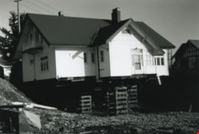
Bottom of the Britton house
https://search.heritageburnaby.ca/link/archivedescription36584
- Repository
- City of Burnaby Archives
- Date
- November 1992
- Collection/Fonds
- Burnaby Historical Society fonds
- Description Level
- Item
- Physical Description
- 1 photograph : b&w ; 10 x 15 cm print
- Scope and Content
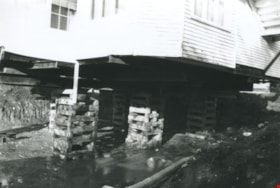
- Photograph of the bottom of the Britton house during the Britton house moving project. A large pooling of water is visible at the bottom of the house as well as a wheelbarrow on the lower left side.
- Repository
- City of Burnaby Archives
- Date
- November 1992
- Collection/Fonds
- Burnaby Historical Society fonds
- Subseries
- Britton family subseries
- Physical Description
- 1 photograph : b&w ; 10 x 15 cm print
- Description Level
- Item
- Record No.
- 303-006
- Access Restriction
- No restrictions
- Reproduction Restriction
- Reproduce for fair dealing purposes only
- Accession Number
- BHS1992-44
- Scope and Content
- Photograph of the bottom of the Britton house during the Britton house moving project. A large pooling of water is visible at the bottom of the house as well as a wheelbarrow on the lower left side.
- Subjects
- Buildings - Residential - Houses
- Media Type
- Photograph
- Notes
- Title based on contents of photograph
- 1 b&w negative accompanying
- Geographic Access
- Kingsway
- Street Address
- 7505 Kingsway
- Historic Neighbourhood
- Edmonds (Historic Neighbourhood)
- Planning Study Area
- Stride Avenue Area
Images
Britton house
https://search.heritageburnaby.ca/link/archivedescription36579
- Repository
- City of Burnaby Archives
- Date
- November 1992
- Collection/Fonds
- Burnaby Historical Society fonds
- Description Level
- Item
- Physical Description
- 1 photograph : b&w ; 10 x 15 cm print
- Scope and Content
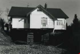
- Photograph of the back door of the Britton house while the house is up on stilts.
- Repository
- City of Burnaby Archives
- Date
- November 1992
- Collection/Fonds
- Burnaby Historical Society fonds
- Subseries
- Britton family subseries
- Physical Description
- 1 photograph : b&w ; 10 x 15 cm print
- Description Level
- Item
- Record No.
- 303-001
- Access Restriction
- No restrictions
- Reproduction Restriction
- Reproduce for fair dealing purposes only
- Accession Number
- BHS1992-44
- Scope and Content
- Photograph of the back door of the Britton house while the house is up on stilts.
- Subjects
- Buildings - Residential - Houses
- Media Type
- Photograph
- Notes
- Title based on contents of photograph
- 1 b&w negative accompanying
- Geographic Access
- Kingsway
- Street Address
- 7505 Kingsway
- Historic Neighbourhood
- Edmonds (Historic Neighbourhood)
- Planning Study Area
- Stride Avenue Area
Images
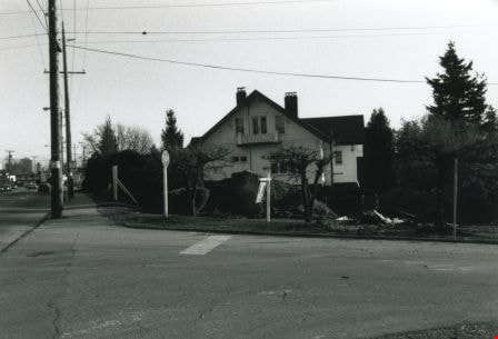
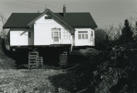
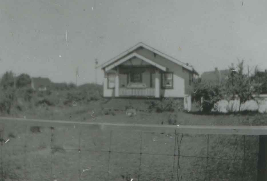
Britton house from across the street
https://search.heritageburnaby.ca/link/archivedescription36582
- Repository
- City of Burnaby Archives
- Date
- November 1992
- Collection/Fonds
- Burnaby Historical Society fonds
- Description Level
- Item
- Physical Description
- 1 photograph : b&w ; 10 x 15 cm print
- Scope and Content
- Photograph of the side of the Britton house during the Britton house moving project, taken across the street from the house.
- Repository
- City of Burnaby Archives
- Date
- November 1992
- Collection/Fonds
- Burnaby Historical Society fonds
- Subseries
- Britton family subseries
- Physical Description
- 1 photograph : b&w ; 10 x 15 cm print
- Description Level
- Item
- Record No.
- 303-004
- Access Restriction
- No restrictions
- Reproduction Restriction
- Reproduce for fair dealing purposes only
- Accession Number
- BHS1992-44
- Scope and Content
- Photograph of the side of the Britton house during the Britton house moving project, taken across the street from the house.
- Subjects
- Buildings - Residential - Houses
- Media Type
- Photograph
- Notes
- Title based on contents of photograph
- 1 b&w negative accompanying
- Geographic Access
- Kingsway
- Street Address
- 7505 Kingsway
- Historic Neighbourhood
- Edmonds (Historic Neighbourhood)
- Planning Study Area
- Stride Avenue Area
Images