![Bruce, Bill and Mary Patterson, [between 1885 and 1890] (date of original), copied 1977 thumbnail](/media/hpo/_Data/_BVM_Images/1977/1977_0099_0010_001.jpg?width=280)
Bruce, Bill and Mary Patterson
https://search.heritageburnaby.ca/link/museumdescription568
- Repository
- Burnaby Village Museum
- Date
- [between 1885 and 1890] (date of original), copied 1977
- Collection/Fonds
- Burnaby Village Museum Photograph collection
- Description Level
- Item
- Physical Description
- 1 photograph : b&w ; 25.2 x 20.2 cm print
- Scope and Content
- Photograph of three children taken in a photographic studio. There is a boy, and a girl, both dressed in sailor suits, and a baby in a dress and white bonnet sitting on a wooden chair. The inscription and accession register identify the children as Bruce, Bill and Mary Patterson. An earlier catalog…
- Repository
- Burnaby Village Museum
- Collection/Fonds
- Burnaby Village Museum Photograph collection
- Description Level
- Item
- Physical Description
- 1 photograph : b&w ; 25.2 x 20.2 cm print
- Scope and Content
- Photograph of three children taken in a photographic studio. There is a boy, and a girl, both dressed in sailor suits, and a baby in a dress and white bonnet sitting on a wooden chair. The inscription and accession register identify the children as Bruce, Bill and Mary Patterson. An earlier catalogue record notes that the caption on the back of the original photograph read: "For Dear Grandpapa Grandma from Bruce Willie & May Patterson." An annotation on the back of this photo reads: "B. Paterson [sic], brother Bill, Mary Patterson, c. 1885-1890?"
- Accession Code
- HV977.99.10
- Access Restriction
- No restrictions
- Reproduction Restriction
- May be restricted by third party rights
- Date
- [between 1885 and 1890] (date of original), copied 1977
- Media Type
- Photograph
- Scan Resolution
- 600
- Scan Date
- 2023-07-11
- Notes
- Title based on contents of photograph
Images
![Bruce, Bill and Mary Patterson, [between 1885 and 1890] (date of original), copied 1977 thumbnail](/media/hpo/_Data/_BVM_Images/1977/1977_0099_0010_001.jpg)
![Caroline Mary Bateman, [1881] thumbnail](/media/hpo/_Data/_BVM_Images/1975/1975_0120_0007_001.jpg?width=280)
Caroline Mary Bateman
https://search.heritageburnaby.ca/link/museumdescription905
- Repository
- Burnaby Village Museum
- Date
- [1881]
- Collection/Fonds
- E.W. Bateman family fonds
- Description Level
- Item
- Physical Description
- 1 photograph : sepia ; 9.2 x 5.8 cm mounted on card 10.2 x 6.2 cm
- Scope and Content
- Photograph of Caroline Mary Bateman at age fourty-two. Caroline Bateman has her hair parted in the middle with ringlets hanging over her shoulder. She is wearing earrings and dark coloured dress with a light ruffled piece at her throat. . Caroline Mary Bateman (the mother of E.W. Bateman) was the d…
- Repository
- Burnaby Village Museum
- Collection/Fonds
- E.W. Bateman family fonds
- Description Level
- Item
- Physical Description
- 1 photograph : sepia ; 9.2 x 5.8 cm mounted on card 10.2 x 6.2 cm
- Material Details
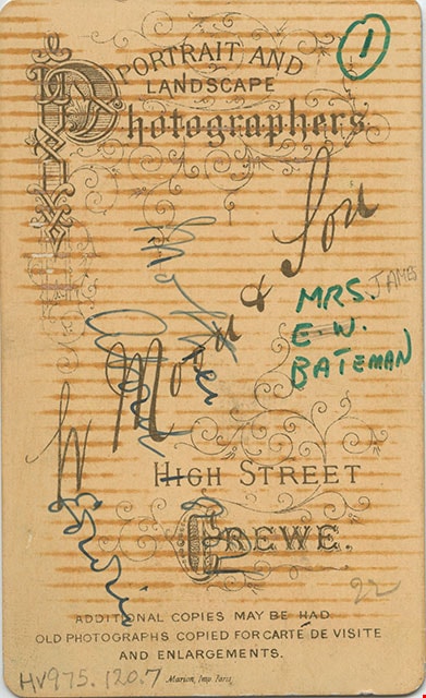
- printed on the card, recto, l.l., "MOON & SON.", l.r. "CREWE.", verso, t. "PORTRAIT AND/ LANDSCAPE/ PHOTOGRAPHERS", c. "W Moon + Son/ HIGH STREET/ CREWE.", b. "ADDITIONAL COPIES MAY BE HAD/ OLD PHOTOGRAPHS COPIED FOR CARTE DE VISITE/ AND ENLARGEMENTS / Marion, Imp. Paris"
- Scope and Content
- Photograph of Caroline Mary Bateman at age fourty-two. Caroline Bateman has her hair parted in the middle with ringlets hanging over her shoulder. She is wearing earrings and dark coloured dress with a light ruffled piece at her throat. . Caroline Mary Bateman (the mother of E.W. Bateman) was the daughter of Edwin Wettenhall, son of Lancaster Wettenhall, Rector of Lawton Church, Cheshire from 1782-1824. Caroline Mary Wettenhall married James Bateman.
- Accession Code
- HV975.120.7
- Access Restriction
- No restrictions
- Reproduction Restriction
- No known restrictions
- Date
- [1881]
- Media Type
- Photograph
- Scan Resolution
- 600
- Scan Date
- 2023-06-13
- Photographer
- W. Moon & Son
- Notes
- Title based on contents of photograph
- An annotation on the back of the card reads: "Mother / About 1881 / Edwin," and was likely written by Edwin Wettenhall Bateman. Edwin Bateman built the house "Elworth" located at the Burnaby Village Museum
- An annotation on the bottom recto of card reads: "Died 2 June 1891 / Age 52."
Images
![Caroline Mary Bateman, [1881] thumbnail](/media/hpo/_Data/_BVM_Images/1975/1975_0120_0007_001.jpg)
![Edgar Sprott, [188-] (date of original), copied 1978 thumbnail](/media/hpo/_Data/_BVM_Images/1978/1978_0001_0005_001.jpg?width=280)
Edgar Sprott
https://search.heritageburnaby.ca/link/museumdescription451
- Repository
- Burnaby Village Museum
- Date
- [188-] (date of original), copied 1978
- Collection/Fonds
- Burnaby Village Museum Photograph collection
- Description Level
- Item
- Physical Description
- 1 photograph : b&w ; 25.2 x 20.2 cm print
- Scope and Content
- Photograph of Edgar Sprott dressed in a suit with a vest and bow tie taken in a photographic studio.
- Repository
- Burnaby Village Museum
- Collection/Fonds
- Burnaby Village Museum Photograph collection
- Description Level
- Item
- Physical Description
- 1 photograph : b&w ; 25.2 x 20.2 cm print
- Scope and Content
- Photograph of Edgar Sprott dressed in a suit with a vest and bow tie taken in a photographic studio.
- Names
- Sprott, Louis "Edgar"
- Accession Code
- HV978.1.5
- Access Restriction
- No restrictions
- Reproduction Restriction
- No known restrictions
- Date
- [188-] (date of original), copied 1978
- Media Type
- Photograph
- Scan Resolution
- 600
- Scan Date
- 2023-07-25
- Notes
- Title based on contents of photograph
Images
![Edgar Sprott, [188-] (date of original), copied 1978 thumbnail](/media/hpo/_Data/_BVM_Images/1978/1978_0001_0005_001.jpg)
![Edwin Wettenhall Bateman, [1881] thumbnail](/media/hpo/_Data/_BVM_Images/1975/1975_0120_0008_001.jpg?width=280)
Edwin Wettenhall Bateman
https://search.heritageburnaby.ca/link/museumdescription906
- Repository
- Burnaby Village Museum
- Date
- [1881]
- Collection/Fonds
- E.W. Bateman family fonds
- Description Level
- Item
- Physical Description
- 1 photograph : sepia ; 8.9 x 6.1 cm mounted on card 10.4 x 6.3 cm
- Scope and Content
- Photograph of Edwin Wettenhall Bateman, about age twenty-two, taken in 1881 according to the inscription on the back. Edwin Bateman is wearing his hair short and parted down the middle, with sideburns and a moustache. His dark coat is buttoned high with one button and his tie is a band that fits on…
- Repository
- Burnaby Village Museum
- Collection/Fonds
- E.W. Bateman family fonds
- Description Level
- Item
- Physical Description
- 1 photograph : sepia ; 8.9 x 6.1 cm mounted on card 10.4 x 6.3 cm
- Scope and Content
- Photograph of Edwin Wettenhall Bateman, about age twenty-two, taken in 1881 according to the inscription on the back. Edwin Bateman is wearing his hair short and parted down the middle, with sideburns and a moustache. His dark coat is buttoned high with one button and his tie is a band that fits only under the collar and does not hang down below it. This photograph was probably taken shortly before E.W. Bateman left England for Manitoba. E.W. Bateman built the house "Elworth" at the Burnaby Village Museum.
- Names
- Bateman, Edwin W.
- Accession Code
- HV975.120.8
- Access Restriction
- No restrictions
- Reproduction Restriction
- No known restrictions
- Date
- [1881]
- Media Type
- Photograph
- Scan Resolution
- 600
- Scan Date
- 2023-06-13
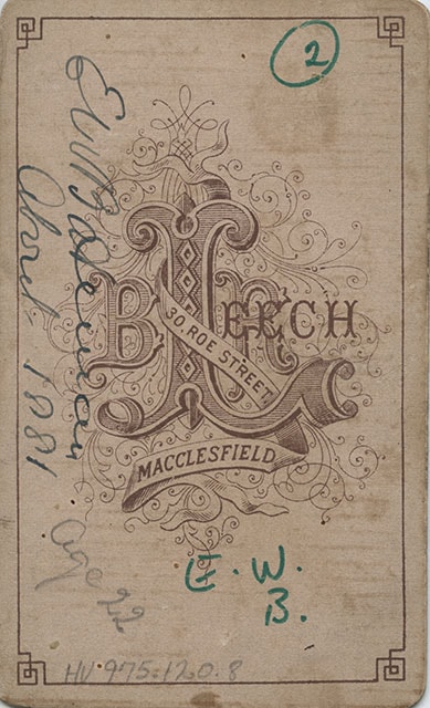
- Photographer
- Leech, B.R.
- Notes
- Title based on contents of photograph
- Printed on the bottom front of the photograph: "B.R. Leech. Photo. / Macclesfield." P
- Printed inscription on veso of card reads: "B.R. Leech / 30, Roe Street. Macclesfield."
- Annotations on verso of card reads: "EW Bateman / About 1881 / Age 22 / E.W. / B."
Images
![Edwin Wettenhall Bateman, [1881] thumbnail](/media/hpo/_Data/_BVM_Images/1975/1975_0120_0008_001.jpg)
![Elizabeth Love, [ca. 1870] thumbnail](/media/hpo/_Data/_BVM_Images/2018/2018_0041_0182_001.jpg?width=280)
Elizabeth Love
https://search.heritageburnaby.ca/link/museumdescription9997
- Repository
- Burnaby Village Museum
- Date
- [ca. 1870]
- Collection/Fonds
- Burnaby Village Museum fonds
- Description Level
- Item
- Physical Description
- 1 photograph : b&w negative ; 35 mm
- Scope and Content
- Photograph portrait of Elizabeth Love (nee Prince) seated next to a decorative wooden desk with a book on top. She is seated on a velvet chair and is wearing a long black silk dress with a decorative lace collar and bonnet. Eizabeth Love was married to Richard Love and is the mother of Jesse Love.
- Repository
- Burnaby Village Museum
- Collection/Fonds
- Burnaby Village Museum fonds
- Series
- Jesse Love farmhouse series
- Subseries
- Love family photographs subseries
- Description Level
- Item
- Physical Description
- 1 photograph : b&w negative ; 35 mm
- Scope and Content
- Photograph portrait of Elizabeth Love (nee Prince) seated next to a decorative wooden desk with a book on top. She is seated on a velvet chair and is wearing a long black silk dress with a decorative lace collar and bonnet. Eizabeth Love was married to Richard Love and is the mother of Jesse Love.
- Accession Code
- BV018.41.182
- Access Restriction
- No restrictions
- Reproduction Restriction
- May be restricted by third party rights
- Date
- [ca. 1870]
- Media Type
- Photograph
- Scan Resolution
- 2400
- Scan Date
- 4-Mar-2019
- Scale
- 100
- Notes
- Title based on contents of photograph
- 1 b&w copy print accompanying
- Stamp in black ink on verso of original photograph reads: "Z.DODSON, / PORTRAIT AND LANDSCAPE / PHOTOGRAPHER / PROSPECT PLACE, / (Near Victoria Street.) / SWINDON."
Images
![Elizabeth Love, [ca. 1870] thumbnail](/media/hpo/_Data/_BVM_Images/2018/2018_0041_0182_001.jpg)

Interview with Marianne May Bateman February 22, 1978 - Track 3
https://search.heritageburnaby.ca/link/oralhistory190
- Repository
- City of Burnaby Archives
- Date Range
- 1880-1920
- Length
- 0:08:39
- Summary
- This portion of the interview pertains to Marianne May Bateman's father Edwin Bateman's history of first coming to Canada.
- Repository
- City of Burnaby Archives
- Summary
- This portion of the interview pertains to Marianne May Bateman's father Edwin Bateman's history of first coming to Canada.
- Date Range
- 1880-1920
- Photo Info
- Photograph of Edwin Wettenhall Bateman with his four daughters; Marianne May is sitting on a chair beside her father, [1903}. Item no. BV992.29.1
- Length
- 0:08:39
- Names
- Bateman, Edwin W.
- Interviewer
- Stevens, Colin
- Interview Date
- February 22, 1978
- Scope and Content
- Recording is of an interview with Marianne May "May" Bateman conducted by Colin Stevens, February 22, 1978. Major themes discussed are: Elworth.
- Biographical Notes
- May Bateman was born in 1894 in Portage LaPrairie, Manitoba, to Edwin Wettenhall Bateman and Cassie (Dale) Bateman. May's father, Edwin Bateman was born in 1859 in Sandbach, Cheshire, to James and Caroline Mary Wettenhall Bateman (their home in Sandbach was called Elworth Cottage). When he was 21, E.W. Bateman immigrated to Manitoba, Canada, where he met Catherine “Cassie” Dale, daughter of George and Sarah Gillon Dale. They were married in Portage La Prairie, Manitoba, on November 9, 1886. Edwin and Cassie had seven children: the eldest Edna Caroline Annie (Corner) born in 1889; George, Mamie (McWilliams) born in 1892; Marianne May “May” Bateman born in 1894; Jessie (Fox Kemp); Carey; and the youngest, Warren Stafford born in 1901. Cassie (Dale) Bateman died in Portage La Prairie in 1909. Edwin was transferred to Vancouver by the Canadian Pacific Railway where he married Cassie’s younger sister Mary Dale, born 1865, and moved his six children to Vancouver. The Bateman family first lived at 7th and Balsam in a large new house. It wasn’t until 1920 that they decided to move to the quieter atmosphere of the Burnaby Lake-Deer Lake area. By this time, Edwin Wettenhall Bateman was a retired CPR executive. He moved his wife and daughter May to Deer Lake and commissioned 'Elworth' house, designed by English-born and trained architect Enoch Evans. The house was completed by contractor William Dodson in 1922 and located at the site of what would become Burnaby Village Museum, 6501 Deer Lake Avenue. The Batemans lived in Burnaby for 15 years before moving back to Vancouver in May of 1935. Mary Bateman died July 5, 1935. Edwin Wettenhall Bateman died on November 25, 1957, at the age of 97. Marianne May Bateman died in 1990.
- Total Tracks
- 4
- Total Length
- 0:30:44
- Interviewee Name
- Bateman, Marianne May
- Collection/Fonds
- Burnaby Historical Society fonds
- Subseries
- Oral history subseries
- Media Type
- Sound Recording
- Web Notes
- Interview was digitized in 2010 allowing it to be accessible on Heritage Burnaby. The digitization project was initiated by the Community Heritage Commission with support from City of Burnaby Council and the BC History Digitization Program of the Irving K. Barber Learning Centre, University of British Columbia. It was recognized by the Heritage Society of BC with an award in 2012.
Images

Audio Tracks
Track three of interview with May Bateman
Track three of interview with May Bateman
https://search.heritageburnaby.ca/media/hpo/_Data/_Archives_Oral_Histories/_Unrestricted/MSS137-014-1/MSS137-014-1_Track_3.mp3![Louisa Killam Richardson, [between 1885 and 1895] thumbnail](/media/hpo/_Data/_BVM_Images/1988/1988_0050_0003_001.jpg?width=280)
Louisa Killam Richardson
https://search.heritageburnaby.ca/link/museumdescription111
- Repository
- Burnaby Village Museum
- Date
- [between 1885 and 1895]
- Collection/Fonds
- Burnaby Village Museum Photograph collection
- Description Level
- Item
- Physical Description
- 1 photograph : b&w ; 14 x 10 cm mounted on card 22.5 x 15 cm
- Scope and Content
- Photograph of Louisa Killam Richardson wearing a long ornate dress that she is believed to have made herself. She is standing in a photographic studio with her right hand holding onto the arm of a chair. Lousia was born in 1865 in Nova Scotia and later married Simon Walter Richardson.
- Repository
- Burnaby Village Museum
- Collection/Fonds
- Burnaby Village Museum Photograph collection
- Description Level
- Item
- Physical Description
- 1 photograph : b&w ; 14 x 10 cm mounted on card 22.5 x 15 cm
- Scope and Content
- Photograph of Louisa Killam Richardson wearing a long ornate dress that she is believed to have made herself. She is standing in a photographic studio with her right hand holding onto the arm of a chair. Lousia was born in 1865 in Nova Scotia and later married Simon Walter Richardson.
- Accession Code
- BV988.50.3
- Access Restriction
- No restrictions
- Reproduction Restriction
- No known restrictions
- Date
- [between 1885 and 1895]
- Media Type
- Photograph
- Related Material
- Some of the dresses and textile works in the accession BV988.50 were made by and belonged to Louisa Killam Richardson.
- Scan Resolution
- 600
- Scan Date
- 2024-04-16
- Photographer
- Webster, William A.
- Notes
- Title based on contents of photograph
- Note in pencil on verso of photograph reads: "Louisa Killam Richardson/ wife of Simon Walter Richardson/ Born about 1865 in/ Nova Scotia/ The old handmade dress +/ black cape belonged to her +/ were made by her."
- Embossed on recto of card mount (lower right) reads: "Wm. A. Webster / Waltham, Mass."
Images
![Louisa Killam Richardson, [between 1885 and 1895] thumbnail](/media/hpo/_Data/_BVM_Images/1988/1988_0050_0003_001.jpg)


Love family correspondence
https://search.heritageburnaby.ca/link/museumdescription10087
- Repository
- Burnaby Village Museum
- Date
- 1880-1911
- Collection/Fonds
- Love family fonds
- Description Level
- File
- Physical Description
- 1 folder of textual records
- Scope and Content
- File consists of a series of personal letters from family members in England to Jesse and Martha Love., including; Sept 22, 1880- to Jesse and Martha Love from Jesse's mother Elizabeth Love; June 7th, 1880- to Jesse from his mother Elizabeth Love; June 9th, 1880- Letter to Jesse Love from his moth…
- Repository
- Burnaby Village Museum
- Collection/Fonds
- Love family fonds
- Description Level
- File
- Physical Description
- 1 folder of textual records
- Scope and Content
- File consists of a series of personal letters from family members in England to Jesse and Martha Love., including; Sept 22, 1880- to Jesse and Martha Love from Jesse's mother Elizabeth Love; June 7th, 1880- to Jesse from his mother Elizabeth Love; June 9th, 1880- Letter to Jesse Love from his mother Elizabeth Love; April 26, 1880 - to Jesse and Martha Love from Jesse's mother Elizabeth Love; May 21, 1881 -To Jesse Love from one of his sisters regarding his mother's death; Jan 18, 1892 - Swindon - to Jesse from his sister, informing him of his father's death; 8th Jan 1906 - to Jesse from his sister,Torie Love; 28 Oct 1910 - to Martha Love from Jesse's sister Torie Love; 27th, (month?) 1910 - to Jesse Love and one of his sisters from Jesse's sister Torie; 14th July 1911 - Letter to Jesse and Martha Love from Jesse's sister Torie; an envelope - addressed to "Mr. Jesse Love / East Burnaby, New Westminster / B.C." postmarked "Jan __ 05 / SWINDON STATION" (does not appear to relate to any of the dates of the letters) and a small evelope addressed to : "Mrs Love / Burnaby".
- History
- See extensive history of Love Family and Love farmhouse located at Burnaby Village Museum.
- Accession Code
- BV012.31.19
- Access Restriction
- No restrictions
- Reproduction Restriction
- No known restrictions
- Date
- 1880-1911
- Media Type
- Textual Record
- Scan Resolution
- 300
- Scan Date
- Feb-02-2012
- Scale
- 96
- Notes
- Title based on content of file
Images

![Man in a tweed coat, [between 1870 and 1889] thumbnail](/media/hpo/_Data/_BVM_Images/1985/198557630001.jpg?width=280)
Man in a tweed coat
https://search.heritageburnaby.ca/link/museumdescription1390
- Repository
- Burnaby Village Museum
- Date
- [between 1870 and 1889]
- Collection/Fonds
- Burnaby Village Museum Photograph collection
- Description Level
- Item
- Physical Description
- 1 photograph : b&w hand-tinted into col.
- Scope and Content
- Photograph of an unidentified man dressed in a tweed coat and collarless jacket taken in a photographic studio. He has a full beard. The cheeks and the lips are hand tinted pink.
- Repository
- Burnaby Village Museum
- Collection/Fonds
- Burnaby Village Museum Photograph collection
- Description Level
- Item
- Physical Description
- 1 photograph : b&w hand-tinted into col.
- Scope and Content
- Photograph of an unidentified man dressed in a tweed coat and collarless jacket taken in a photographic studio. He has a full beard. The cheeks and the lips are hand tinted pink.
- Accession Code
- BV985.5763.1
- Access Restriction
- No restrictions
- Reproduction Restriction
- No known restrictions
- Date
- [between 1870 and 1889]
- Media Type
- Photograph
- Scan Resolution
- 600
- Scan Date
- 2024-02-02
- Notes
- Title based on contents of photograph
Images
![Man in a tweed coat, [between 1870 and 1889] thumbnail](/media/hpo/_Data/_BVM_Images/1985/198557630001.jpg)
Memorial card for Elizabeth Love
https://search.heritageburnaby.ca/link/museumdescription10091
- Repository
- Burnaby Village Museum
- Date
- 1881
- Collection/Fonds
- Love family fonds
- Description Level
- Item
- Physical Description
- 1 card
- Scope and Content
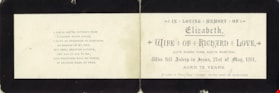
- Item consists of a memorial card for Elizabeth Love and reads "IN LOVING MEMORY OF / Elizabeth, / WIFE OF RICHARD LOVE / (LATE RUBRO FARM, SOUTH MARSTON.) / Who fell Asleep in Jesus, 21st of May, 1881 / AGED 72 YEARS". A short, religious poem is printed on one fragment of the card.
- Repository
- Burnaby Village Museum
- Collection/Fonds
- Love family fonds
- Description Level
- Item
- Physical Description
- 1 card
- Scope and Content
- Item consists of a memorial card for Elizabeth Love and reads "IN LOVING MEMORY OF / Elizabeth, / WIFE OF RICHARD LOVE / (LATE RUBRO FARM, SOUTH MARSTON.) / Who fell Asleep in Jesus, 21st of May, 1881 / AGED 72 YEARS". A short, religious poem is printed on one fragment of the card.
- History
- See extensive history of Love Family and Love farmhouse located at Burnaby Village Museum.
- Accession Code
- BV012.31.23
- Access Restriction
- No restrictions
- Reproduction Restriction
- No known restrictions
- Date
- 1881
- Media Type
- Textual Record
- Notes
- Title based on content of file
Images

![Ontario Liquor Store, [between 1880 and 1899] thumbnail](/media/hpo/_Data/_BVM_Images/1974/1974_0130_0056_001.jpg?width=280)
Ontario Liquor Store
https://search.heritageburnaby.ca/link/museumdescription3061
- Repository
- Burnaby Village Museum
- Date
- [between 1880 and 1899]
- Collection/Fonds
- Burnaby Village Museum Photograph collection
- Description Level
- Item
- Physical Description
- 1 photograph : b&w tintype ; 10.6 x 13.8 cm
- Scope and Content
- Photograph of an L shaped building with a flat front. Letters on the front of the store read, "Ontario Liquor Store / Grocery / Tailor." Four men are standing near the store on the boardwalk, three boys are sitting, and a woman is standing on the boardwalk leaning against the fence on the far lef…
- Repository
- Burnaby Village Museum
- Collection/Fonds
- Burnaby Village Museum Photograph collection
- Description Level
- Item
- Physical Description
- 1 photograph : b&w tintype ; 10.6 x 13.8 cm
- Scope and Content
- Photograph of an L shaped building with a flat front. Letters on the front of the store read, "Ontario Liquor Store / Grocery / Tailor." Four men are standing near the store on the boardwalk, three boys are sitting, and a woman is standing on the boardwalk leaning against the fence on the far left. As is normal for most tintypes, the image appears reversed, left to right. (Few tintype cameras included a mirror or prism that made the image appear 'right way round').
- History
- From Denby Bros. Shoe Store at 163 West Pender in Vancouver. Stafford Ague Denby (1882-1957) started peddling shoe findings in 1918 around Vancouver to repair shops around town from the back of an old Ford. Two of his brothers, William Albert (1873-1947) and Melvin Stanley (1879-1953) joined him in 1919 to form Denby Bros & Co. Ltd Leather and Shoe Findings at 163 West Pender. William Gordon Pope started helping out in the shoe store at the age of 10. He eventually ran the store with his cousin, Pat Denby (son of William A. Denby) starting in the 1950s. The store closed in 1974.
- Subjects
- Buildings - Commercial - Stores
- Accession Code
- HV974.130.56
- Access Restriction
- No restrictions
- Reproduction Restriction
- No known restrictions
- Date
- [between 1880 and 1899]
- Media Type
- Photograph
- Scan Resolution
- 600
- Scan Date
- 2023-05-09
- Scale
- 100
- Notes
- Title based on contents of photograph
Images
![Ontario Liquor Store, [between 1880 and 1899] thumbnail](/media/hpo/_Data/_BVM_Images/1974/1974_0130_0056_001.jpg)
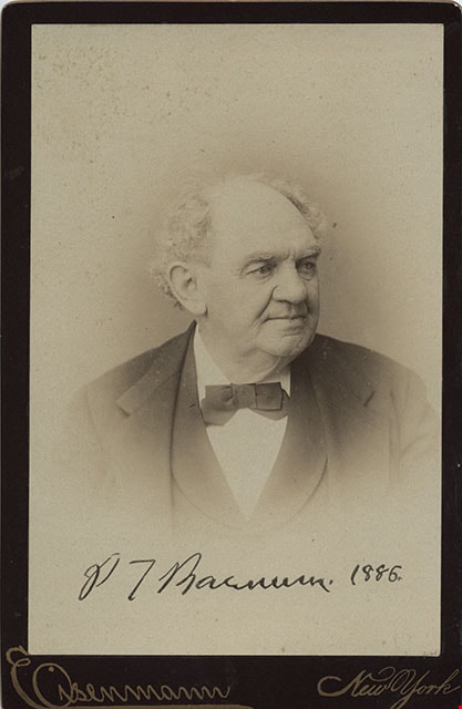
Phineas Taylor Barnum
https://search.heritageburnaby.ca/link/museumdescription3348
- Repository
- Burnaby Village Museum
- Date
- 1886
- Collection/Fonds
- Burnaby Village Museum Photograph collection
- Description Level
- Item
- Physical Description
- 1 photograph : b&w ; 14.5 x 9.5 cm mounted on cardboard 16.5 x 10.7 cm
- Scope and Content
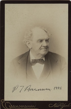
- Photograph of Phineas Taylor Barnum (1810-1891), the founder of the circus that would eventually become the Ringling Brothers and Barnum and Bailey Circus. He is 76 years of age at this time with grey hair, wearing a suit with a vest and a bow tie. Annotated or stamped on the bottom front of the ph…
- Repository
- Burnaby Village Museum
- Collection/Fonds
- Burnaby Village Museum Photograph collection
- Description Level
- Item
- Physical Description
- 1 photograph : b&w ; 14.5 x 9.5 cm mounted on cardboard 16.5 x 10.7 cm
- Scope and Content
- Photograph of Phineas Taylor Barnum (1810-1891), the founder of the circus that would eventually become the Ringling Brothers and Barnum and Bailey Circus. He is 76 years of age at this time with grey hair, wearing a suit with a vest and a bow tie. Annotated or stamped on the bottom front of the photograph: "P.T. Barnum. 1886." Printed on the bottom front of the card: "Eisenmann / New York." Printed on the back of the card, "Chas. Eisenmann / Instantaeous Photographer / Trade Mark / The Popular Photographer / 229 Bowery, N.Y. / Branch Gallery 18 West 14th Str. N.Y."
- Names
- Barnum, P.T.
- Accession Code
- HV975.61.153c
- Access Restriction
- No restrictions
- Reproduction Restriction
- No known restrictions
- Date
- 1886
- Media Type
- Photograph
- Scan Resolution
- 600
- Scan Date
- 2023-06-06
- Photographer
- Eisenmann, Charles
- Notes
- Title based on contents of photograph
- This photograph was removed from photograph album - HV975.61.153
Images
![Richard Love, [ca. 1870] thumbnail](/media/hpo/_Data/_BVM_Images/2018/2018_0041_0181_001.jpg?width=280)
Richard Love
https://search.heritageburnaby.ca/link/museumdescription9996
- Repository
- Burnaby Village Museum
- Date
- [ca. 1870]
- Collection/Fonds
- Burnaby Village Museum fonds
- Description Level
- Item
- Physical Description
- 1 photograph : b&w negative ; 35 mm
- Scope and Content
- Photograph portrait of Richard Love seated next to a decorative wooden desk. He is seated on a chair with a velvet and tassels and is wearing a large black suit coat, a white blouse with a tie at the collar, pants with long velvet chaps that go up to his knees and cover the tops of his shoes. He is…
- Repository
- Burnaby Village Museum
- Collection/Fonds
- Burnaby Village Museum fonds
- Series
- Jesse Love farmhouse series
- Subseries
- Love family photographs subseries
- Description Level
- Item
- Physical Description
- 1 photograph : b&w negative ; 35 mm
- Scope and Content
- Photograph portrait of Richard Love seated next to a decorative wooden desk. He is seated on a chair with a velvet and tassels and is wearing a large black suit coat, a white blouse with a tie at the collar, pants with long velvet chaps that go up to his knees and cover the tops of his shoes. He is holding a wooden cane between his legs and there is a top hat and a book on top of the desk and a back drop hanging from the wall behind him. Richard Love is the father of Jesse Love.
- Names
- Love, Richard
- Accession Code
- BV018.41.181
- Access Restriction
- No restrictions
- Reproduction Restriction
- May be restricted by third party rights
- Date
- [ca. 1870]
- Media Type
- Photograph
- Scan Resolution
- 2400
- Scan Date
- 4-Mar-2019
- Scale
- 100
- Photographer
- Dodson, Z.
- Notes
- Title based on contents of photograph
- 1 b&w copy print accompanying
- Stamp in black ink on verso of original photograph reads: "Z.DODSON, / Photographer / PROSPECT PLACE, / NEAR VICTORIA STREET / SWINDON."
Images
![Richard Love, [ca. 1870] thumbnail](/media/hpo/_Data/_BVM_Images/2018/2018_0041_0181_001.jpg)
![Subdivision plans in New Westminster District Group 1 – Burnaby
, [1882-1910] thumbnail](/media/hpo/_Data/_BVM_Cartographic_Material/1977/1977_0093_0013a_001.jpg?width=280)
Subdivision plans in New Westminster District Group 1 – Burnaby
https://search.heritageburnaby.ca/link/museumdescription6982
- Repository
- Burnaby Village Museum
- Date
- [1882-1910]
- Collection/Fonds
- Burnaby Village Museum Map collection
- Description Level
- File
- Physical Description
- 4 plans : blueprint on paper mounted on 2 sides of cardboard 76 x 102 cm
- Scope and Content
- Item consists of a large board of two New Westminster District Gp 1 - subdivision plans mounted on one side and two New Westminster District Gp 1 - subdivision plans mounted on the other side. Side A: 1. Blueprint "Plan / of the / Subdivision / of / Lot 98 / G.1, N.W.D. / Scale 4 chs = 1 in. / …
- Repository
- Burnaby Village Museum
- Collection/Fonds
- Burnaby Village Museum Map collection
- Description Level
- File
- Physical Description
- 4 plans : blueprint on paper mounted on 2 sides of cardboard 76 x 102 cm
- Material Details
- Scales [between 1:1584 and 1:3168]
- Index number on edge of board reads: "13"
- Scope and Content
- Item consists of a large board of two New Westminster District Gp 1 - subdivision plans mounted on one side and two New Westminster District Gp 1 - subdivision plans mounted on the other side. Side A: 1. Blueprint "Plan / of the / Subdivision / of / Lot 98 / G.1, N.W.D. / Scale 4 chs = 1 in. / Map No 573" (Geographic location: Burnaby) 2. Blueprint "Plan / of Subdivision of / Lot 157 / Gr.1, New. West. Dist. / Scale 3 chs = 1 in. / Map No. 612". (Geographic location: Burnaby) Side B: 1. Blueprint "Plan / of Subdivision / of a Portion of / Lot 90 / Group One / New Westminster Dist. / Scale 2 chs = 1 in. / Map No. 555". Plan is signed by "Jno Strathern [sic]_P.L.S."n (Geographic location: Burnaby) 2. Blueprint "Subdivision of Lot 31, Group 1. / New Westminster District / As Amended by Order of Court / 1st Sept. 1882 and Numbered 847 / Scale 4 chs = 1in. / Map No 80" (Geographic location: Burnaby)
- Creator
- Stathern, John
- Accession Code
- HV977.93.13
- Access Restriction
- No restrictions
- Reproduction Restriction
- No known restrictions
- Date
- [1882-1910]
- Media Type
- Cartographic Material
- Historic Neighbourhood
- Alta Vista (Historic Neighbourhood)
- Planning Study Area
- Richmond Park Area
- Lakeview-Mayfield Area
- Scan Resolution
- 300
- Scale
- 72
- Notes
- Title based on contents of file
- Scale is measured in chains. (One chain equals 792 inches)
- The term "Lot" can also refer to a "District Lot”
Images
![Subdivision plans in New Westminster District Group 1 – Burnaby
, [1882-1910] thumbnail](/media/hpo/_Data/_BVM_Cartographic_Material/1977/1977_0093_0013a_001.jpg)

![Survey and Subdivision plans in New Westminster District Group 1 – Burnaby
, [1861]-[1910] thumbnail](/media/hpo/_Data/_BVM_Cartographic_Material/1977/1977_0093_0019a_001.jpg?width=280)
Survey and Subdivision plans in New Westminster District Group 1 – Burnaby
https://search.heritageburnaby.ca/link/museumdescription6988
- Repository
- Burnaby Village Museum
- Date
- [1861]-[1910]
- Collection/Fonds
- Burnaby Village Museum Map collection
- Description Level
- File
- Physical Description
- 14 plans : 3 plans : black ink on paper hand col. + 7 plans : black ink on paper + 4 plans : graphite on paper mounted on 2 sides of cardboard 76 x 102 cm
- Scope and Content
- Item consists of a large board of four New Westminster District Gp 1 - subdivision plans mounted on one side and ten New Westminster District Gp 1 - subdivision plans mounted on the other side. Side A: 1. "Plan /of / Lots 166A, 166 and 167 /, Gr.1, N.W.D. / Showing Misconstructed Roads in Gree…
- Repository
- Burnaby Village Museum
- Collection/Fonds
- Burnaby Village Museum Map collection
- Description Level
- File
- Physical Description
- 14 plans : 3 plans : black ink on paper hand col. + 7 plans : black ink on paper + 4 plans : graphite on paper mounted on 2 sides of cardboard 76 x 102 cm
- Material Details
- Scales [between 1:2376 and 1:7920]
- Index number on edge of board reads: "19"
- Scope and Content
- Item consists of a large board of four New Westminster District Gp 1 - subdivision plans mounted on one side and ten New Westminster District Gp 1 - subdivision plans mounted on the other side. Side A: 1. "Plan /of / Lots 166A, 166 and 167 /, Gr.1, N.W.D. / Showing Misconstructed Roads in Green / 5 chs = 1 in.". (plan is drawn in black ink and hand coloured in red, green and orange ink). A section in the centre of the plan is coloured in red ink and identified as "C.S. Richmond" running from the North Arm of Fraser River to Wiggins Road and divided by "New Wiggins Rd. (as gazetted)" (coloured in orange ink) and two"Constructed Road(s)" (coloured in green ink). Plan is initialed by: "RB" [sic] (in blue pencil crayon) 2. Plan of / Subdivision of / Lot 166 / Group One / New Westminster District / Scale 4 chs = 1 in. / Map No 524". Plan is drawn in graphite and signed by "Surrig [sic] Welhams [sic] / P.L.S." Plan is initialed by: "RB" [sic] (in blue pencil crayon) 3. Plan of "Survey / of Highway / For / Burnaby Council / in / Lots 13 _14 / Group One / Scale 4 chs = 1 in." Signed by "Albert J. Hill, P.L.S." Caribou Street and Caribou Road run through the centre of the plan. Plan is stamped: "Albert J. Hill, Civil Engineer / and / Provincial Land Surveyor, / New Westminster, / B.C.". Plan is initialed by: "RB" [sic] (in blue pencil crayon) 4. A Plan of Lots 166A, 166 and 167, Group One, New Westminster District (drawn in graphite). A section in the centre of the plan is identified as "C.S. Richmond" running from the North Arm of Fraser River and divided by "New Wiggins Rd. (as gazetted)" and two "Constructed Road(s)". Plan is initialed by: "RB" [sic] (in blue pencil crayon) Side B: 1. Small plan drawn in black ink (no title) identifying lots north of the "North Arm" of the Fraser River. Lots identified include: Lot 99, Lot 98, Lot 157, Lot 158, Lot 163, Lot 162, Lot 159, Lot 163, Lot 162, Lot 165, Lot 166A, Lot 155B, Lot 155A and Lot 159. "Scale 40 chains to one inch" . Plan is initialed by: "RB" [sic] (in blue pencil crayon) (Geographic location: Burnaby) 2. Small plan drawn in black ink (no title) identifying lots north of the North Arm of the Fraser River as "Lots 155, 155A, 155B, 155C, 162, 163, 164, 165, 166A and 167". Plan is initialed by: "RB" [sic] (in blue pencil crayon) (Geographic location: Burnaby) 3. Small plan drawn in black ink (no title) which identifies "Lot 151 / Reserve/ for / Race Course"; "Reserve / 64 A / L. 152 G.1"; and other Lots: 32, 33, 34, 35, 36, 38, 39. The plan is signed "Surveyor G.Turn [sic] July / 61 / from Vol 40 R.L. notes [sic]" Plan is stamped: "Albert J. Hill, Civil Engineer / and / Provincial Land Surveyor, / New Westminster, / B.C." Plan is initialed by: "RB" [sic] (in blue pencil crayon) (Geographic location: Burnaby) 4. Small plan drawn in black in with faded red colouring on centre lot identified as "Lot 34" running north from "Vancouver Road" . Plan is stamped: "Albert J. Hill, Civil Engineer / and / Provincial Land Surveyor, / New Westminster, / B.C." Plan is initialed by: "RB" [sic] (in blue pencil crayon) (Geographic location: Burnaby) 5. Plan drawn in graphite and identified as "Lot 98, Gr.1," along with the intials "RB" [sic] (both are handwritten in blue crayon pencil on top of plan) The B.C.E.Railway is identified running through the plan along with Jubilee Road and Royal Oak Road. The plan is signed with the name "Wm. Murray" and the Plan is stamped: "Albert J. Hill, Civil Engineer / and / Provincial Land Surveyor, / New Westminster, / B.C.". (Geographic location: Burnaby) 6. Plan drawn in graphite identified as "Port Lot 13, Gr.1" along with the intials "RB" [sic] (both are handwritten in blue crayon pencil on top of plan) Plan is stamped: "Albert J. Hill, Civil Engineer / and / Provincial Land Surveyor, / New Westminster, / B.C.". (Geographic location: Burnaby) 7.Plan drawn in black ink and identified as "Lot 98 G.1" along with the intials "RB" [sic] (both are handwritten in blue crayon pencil on top of plan). A "Road Reservation" is identified running north between "Electric Tramway" and connecting with "Royal Oak Road". Plan is stamped: "Albert J. Hill, Civil Engineer / and / Provincial Land Surveyor, / New Westminster, / B.C." (Geographic location: Burnaby) 8. Plan drawn in black ink and divided into two sections, the upper plan is identified as "Portion / Lots 100 / area / 101, Gr.1" and the lower plan is identified as "Portion L. 3 G. 1" along with the intials "RB" [sic] (these identifiers are handwritten in blue crayon pencil on top of the plan). Portions of Lot 100 and Lot 101 are each divided into 6 sections and the Portion of Lot 3 plan is divided into 24 sections. The plan includes a note in black ink that reads: " Received from Wm Fromme [sic] / from Wm. Trapp / Nov. 28, 1895 / A. J. T...[sic]". (Geographic location: Burnaby) 9. Plan drawn in black ink (no title) identifying soil, buildings and geographic features in southern Burnaby. The plan is bordered by "New Westminster City" (Tenth Avenue and DL 172) to the south east and DL 173 to the south, DL 158 to the west and the B.C.E. Tramway to the north. Plan includes District Lots: 155A, 158, 159, 171, 160, 53 and 95 and identifies soil, marshland and ravines throughout. Plan identifies the following features: a "Team Road" running through Lots 158 and 159 along with "Fair Orchard Soil / Even Surface Throughout / No Ravines", "Gravel and Shingle" (bottom of Lot 158), "North Arm Road" crossing "Byrne Road" and connecting with "Power House Road" which runs north to connect with "Highland Park Station" and the B.C.E. Tramway, "Power Ho" in the northeast corner of DL 160, a "Brook" connected with a "Deep Ravine" running between DL 53, DL 95 and DL 160 along with "Good Soil" and "Fair Orchard Soil" identified nearby in DL 95. Scale is identified as "10 chs = 1 in." Plan is stamped: "Albert J. Hill, Civil Engineer / and / Provincial Land Surveyor, / New Westminster, / B.C." Plan is initialed by: "RB" [sic] (in blue pencil crayon) (Geographic location: Burnaby) 10. Plan drawn in black ink (no title) with Burnaby Lake and Deer Lake at the centre. The plan is bordered by the following District Lots identified as: 117, 118 and 68 to the west, Lots 80, 79 and 85 to the southwest, Lots 11, 13, and 1 (City of New Westminster) to the south east, the North Road boundary to the east and Lots 8, 56, 57, 59, and 136 to the North. The lower right hand corner of the plan has a small inset which reads: "Burnaby Lake" and "Page 19 R.B. Notes". Plan is initialed by: "RB" [sic] (in blue pencil crayon) (Geographic location: Burnaby)
- Creator
- Hill, Albert James
- Accession Code
- HV977.93.19
- Access Restriction
- No restrictions
- Reproduction Restriction
- No known restrictions
- Date
- [1861]-[1910]
- Media Type
- Cartographic Material
- Scan Resolution
- 300
- Scale
- 72
- Notes
- Title based on contents of file
- Scale is measured in chains. (One chain equals 792 inches)
- The term "Lot" can also refer to a "District Lot”
- Some plans are stamped: "Albert J. Hill, Civil Engineer / and / Provincial Land Surveyor, / New Westminster, / B.C." and intialed: "RB" [sic]
Images
![Survey and Subdivision plans in New Westminster District Group 1 – Burnaby
, [1861]-[1910] thumbnail](/media/hpo/_Data/_BVM_Cartographic_Material/1977/1977_0093_0019a_001.jpg)

![Survey and Subdivision plans in New Westminster District Group 1 – Burnaby, Port Moody, [1862-1908] thumbnail](/media/hpo/_Data/_BVM_Cartographic_Material/1977/1977_0093_0026a_001.jpg?width=280)
Survey and Subdivision plans in New Westminster District Group 1 – Burnaby, Port Moody
https://search.heritageburnaby.ca/link/museumdescription6995
- Repository
- Burnaby Village Museum
- Date
- [1862-1908]
- Collection/Fonds
- Burnaby Village Museum Map collection
- Description Level
- File
- Physical Description
- 9 plans : 6 plans : black ink on paper ; 57 x 36.5 cm or smaller + 1 plan : black ink and grahite on paper ; 46.5 x 49 cm + 1 plan : blueprint on paper ; 15.5 x 19.5 cm + cm + 1 plan : graphite on paper ; 25 x 17 cm ; mounted on both sides of board 76 x 102 cm
- Scope and Content
- Item consists of a large board of four New Westminster District subdivision plans mounted on one side and five New Westminster District subdivision plans mounted on the other side. Side A: 1. "Plan / of Subdivision / of a Portion / of / Lot 87 / Group One / New Westminster District / Scale 4 chs…
- Repository
- Burnaby Village Museum
- Collection/Fonds
- Burnaby Village Museum Map collection
- Description Level
- File
- Physical Description
- 9 plans : 6 plans : black ink on paper ; 57 x 36.5 cm or smaller + 1 plan : black ink and grahite on paper ; 46.5 x 49 cm + 1 plan : blueprint on paper ; 15.5 x 19.5 cm + cm + 1 plan : graphite on paper ; 25 x 17 cm ; mounted on both sides of board 76 x 102 cm
- Material Details
- Scales [between 1:792 and 1:3600]
- Index number on edge of board reads: "26"
- Scope and Content
- Item consists of a large board of four New Westminster District subdivision plans mounted on one side and five New Westminster District subdivision plans mounted on the other side. Side A: 1. "Plan / of Subdivision / of a Portion / of / Lot 87 / Group One / New Westminster District / Scale 4 chs = 1 in". Plan is stamped: "Albert J. Hill, Civil Engineer / and / Provincial Land Surveyor, / New Westminster, / B.C." and intialed by: "RB" [sic] (in blue pencil crayon). Names two of the subdivisons of District Lot 87 are identified as, "L.E. Sprott" and "John Ledger". (Geographic location: Burnaby) 2. "Plan of Subdivision / of / Portions of / Lot 136, 131 and Lots 44 and 78 Gr.1 / New Westminster District / Scale 300 ft = 1 inch". Annotation above title reads: "No. 901 / Deposited in Land Registry Office / New Westminster / Aug. 19th 1905 / Charles S. Keith D. Reg." Annotations and signatures at bottom of plan read: "I, William Nelson Draper, / W.H.R. Collister / Charles E. Perkins / E.B. Morgan / make / Surveys / correct / representation / upon / the / Land Registry Act / (sgd) W.N. Draper, P.L.S.". Plan includes a handwritten title: "Lots 136, 131, 44 & 78" and is initialed: "RB" [sic] (in blue pencil crayon) (Geographic location: Burnaby) 3. "Survey / of / a Portion / of / Lot 95, Gr.1 / Scale 1 ch = 1in." Plan is stamped: "Albert J. Hill, Civil Engineer / and / Provincial Land Surveyor, / New Westminster, / B.C." and is initialed : "RB" [sic] (in blue pencil crayon) (Geographic location: Burnaby) 4. Blueprint plan of "Lot 396. Group One." with Scale : 3 chs = 1 in. A two acre portion of District Lot 396 is filled in with red ink." Plan is signed by "Albert J. Hill / B.C.L.S." (Geographic location: Port Moody) Side B: 1. Plan titled "District Lot 92 / Burnaby / Municipality / for sale by / Mahon / McFarland & / Mahon Ltd. / Vancouver, B.C. / Scale : 4 chains to one inch". District Lot 92 is subdivided into 161 lots and identifies roads: Norwich Road, Pole Line Road, Oakland Road, Stanley Road, Burford Road, Dalhousie Road, Brantford Road, Colborne Road, Roberts Road, Vancouver & Westminster Road, B.C. Electric Railway, Gilley Stn. and Burnaby (Power House). The bottom of the plan reads: "G.S. Dawson, P.LS. Vancouver, B.C." (Geographic location: Burnaby) 2. "Plan / of Subdivision / of a Portion / of / Lot 29 / Group 1 / New Westminster District / Scale 2 chs = 1 in". Plan is stamped: "Albert J. Hill, Civil Engineer / and / Provincial Land Surveyor, / New Westminster, / B.C." and is initialed by: "RB" [sic] (in blue pencil crayon) (Geographic location: Burnaby) 3. Small handrawn plan (no title) identifying "Lot 84 / Hydes, Claim" at the centre surrounded by lots and features identified as: "Lot 85", "Lot 93", "Lot 94", "Lot 32", "Lot 82", "Lot 83", "Lot 79", "swamp" and a "Small Lake" (Burnaby Lake). Identifying marks in the right corner of the plan read: "Page 13 / Surveyed by G. Turner / May 62". Plan also includes surveyor's bearing measurements and trails to "Small Lake" (Burnaby Lake). (Geographic location: Burnaby) 4. Untitled plan showing District Lots west of North Road and north of Burnaby Lake including: Lots 2, 4, 6, 8, 15, 10, 56, 148, 57, 58, 40. and Lots 3, 5, 7 east of North Road (Coquitlam). Lots in Burnaby are identifed for timber including: "Heavily Timbered" (Lot 57), " "Some Fir and Cedar" (Lot 40), "Splendid Fir and Cedar" (Lot 143), "Heavy Fir etc" (Lots 143 and 148), " "Fine Cedar" (Lot 15), "Rough Light Timber" (Lot 56). Other features identified at the lower portion of the plan include "Burnaby Lake" and "Brunette River". (Geographic location: Burnaby) 5. Untitled plan drawn in graphite showing sections of District Lot 85 south of Burnaby Lake and north of Hazsard Road. Plan is signed: "Albert J. Hill / B.C.L.S." and dated "12/26/08". Plan is initialed by: "RB" [sic] (in blue pencil crayon) (Geographic location: Burnaby)
- Publisher
- Mahon, McFarland & Mahon Ltd
- Accession Code
- HV977.93.26
- Access Restriction
- No restrictions
- Reproduction Restriction
- No known restrictions
- Date
- [1862-1908]
- Media Type
- Cartographic Material
- Historic Neighbourhood
- Burnaby Lake (Historic Neighbourhood)
- Burquitlam (Historic Neighbourhood)
- Planning Study Area
- Burnaby Lake Area
- Scan Resolution
- 300
- Scale
- 72
- Notes
- Title based on contents of file
- Scale is measured in chains and feet. (One chain equals 792 inches)
- The term "Lot" can also refer to a "District Lot”
Images
![Survey and Subdivision plans in New Westminster District Group 1 – Burnaby, Port Moody, [1862-1908] thumbnail](/media/hpo/_Data/_BVM_Cartographic_Material/1977/1977_0093_0026a_001.jpg)


![Team of oxen, [1888] thumbnail](/media/hpo/_Data/_BVM_Images/1977/197701400003.jpg?width=280)
Team of oxen
https://search.heritageburnaby.ca/link/museumdescription638
- Repository
- Burnaby Village Museum
- Date
- [1888]
- Collection/Fonds
- Burnaby Village Museum Photograph collection
- Description Level
- Item
- Physical Description
- 1 photograph : sepia ; 19 x 23cm, mounted on card 30 x 35 cm
- Scope and Content
- Photograph of a team of four oxen and their handler working near Kingsway on Gilley Avenue. A second lumberjack is resting on a log as the team moves past.
- Repository
- Burnaby Village Museum
- Collection/Fonds
- Burnaby Village Museum Photograph collection
- Description Level
- Item
- Physical Description
- 1 photograph : sepia ; 19 x 23cm, mounted on card 30 x 35 cm
- Scope and Content
- Photograph of a team of four oxen and their handler working near Kingsway on Gilley Avenue. A second lumberjack is resting on a log as the team moves past.
- Geographic Access
- Gilley Avenue
- Accession Code
- HV977.140.3
- Access Restriction
- No restrictions
- Date
- [1888]
- Media Type
- Photograph
- Historic Neighbourhood
- Fraser Arm (Historic Neighbourhood)
- Scan Resolution
- 600
- Scan Date
- 1/15/2010
- Scale
- 100
- Notes
- Title based on contents of photograph
- Note in pencil on verso of photograph reads: "Near Kingsway on Gilley Ave. about 1888"
Images
![Team of oxen, [1888] thumbnail](/media/hpo/_Data/_BVM_Images/1977/197701400003.jpg)
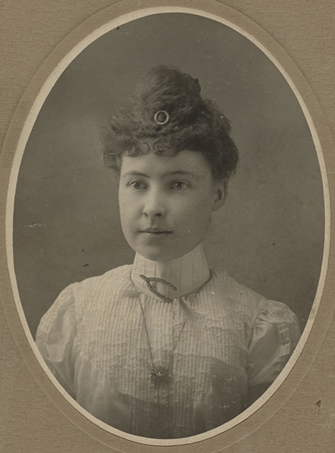
![Woman wearing jewelry, [between 1880 and 1895] thumbnail](/media/hpo/_Data/_BVM_Images/1985/1985_5886_0001_001.jpg?width=280)
Woman wearing jewelry
https://search.heritageburnaby.ca/link/museumdescription1510
- Repository
- Burnaby Village Museum
- Date
- [between 1880 and 1895]
- Collection/Fonds
- Burnaby Village Museum Photograph collection
- Description Level
- Item
- Physical Description
- 1 photograph : b&w ; 14 x 18.5 cm
- Scope and Content
- Photograph is a studio portrait of an unidentified young woman with her curly hair put up and decorated with a round hair pin in the front. She is wearing a white blouse with high neck, and is wearing a brooch shaped like a tuning fork or a wishbone and has a pendent around her neck.
- Repository
- Burnaby Village Museum
- Collection/Fonds
- Burnaby Village Museum Photograph collection
- Description Level
- Item
- Physical Description
- 1 photograph : b&w ; 14 x 18.5 cm
- Material Details
- printed on the card mount, recto, l.r. "Steele & Co./ LTD/ Winnipeg & Calgary"
- The photograph is printed in an oval shape, and mounted on a card supplied by the photo studio. There are scribbles on verso of cardboard.
- Scope and Content
- Photograph is a studio portrait of an unidentified young woman with her curly hair put up and decorated with a round hair pin in the front. She is wearing a white blouse with high neck, and is wearing a brooch shaped like a tuning fork or a wishbone and has a pendent around her neck.
- Subjects
- Adornment - Jewelry
- Clothing
- Accession Code
- BV985.5886.1
- Access Restriction
- No restrictions
- Reproduction Restriction
- No known restrictions
- Date
- [between 1880 and 1895]
- Media Type
- Photograph
- Scan Resolution
- 600
- Scan Date
- 2024-02-27
- Photographer
- Steele & Co.
- Notes
- Title based on contents of photograph
Images
![Woman wearing jewelry, [between 1880 and 1895] thumbnail](/media/hpo/_Data/_BVM_Images/1985/1985_5886_0001_001.jpg)
![Woman with glasses, [between 1880 and 1895] thumbnail](/media/hpo/_Data/_BVM_Images/1985/1985_5897_0001_002.jpg?width=280)
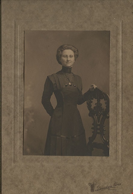
Woman with glasses
https://search.heritageburnaby.ca/link/museumdescription1522
- Repository
- Burnaby Village Museum
- Date
- [between 1880 and 1895]
- Collection/Fonds
- Burnaby Village Museum Photograph collection
- Description Level
- Item
- Physical Description
- 1 photograph : sepia photogravure ; 9.5 x 14 cm
- Scope and Content
- Photogravure is from a studio portrait of an unidentified woman wearing a dark dress and eye glasses, standing by an ornate wooden post. She is wearing a leaf-shaped pendant around her neck.
- Repository
- Burnaby Village Museum
- Collection/Fonds
- Burnaby Village Museum Photograph collection
- Description Level
- Item
- Physical Description
- 1 photograph : sepia photogravure ; 9.5 x 14 cm
- Material Details
- printed on the card mount, recto, l.r. "[emblem in shape of sheaf of wheat] Davidson Bros/ BRANDON,/ MAN."
- The photogravure is mounted on a card, then mounted inside a folder, with a protective tissue paper.
- Scope and Content
- Photogravure is from a studio portrait of an unidentified woman wearing a dark dress and eye glasses, standing by an ornate wooden post. She is wearing a leaf-shaped pendant around her neck.
- Subjects
- Clothing
- Accession Code
- BV985.5897.1
- Access Restriction
- No restrictions
- Reproduction Restriction
- No known restrictions
- Date
- [between 1880 and 1895]
- Media Type
- Photograph
- Scan Resolution
- 600
- Scan Date
- 2024-02-27
- Photographer
- Davidson Brothers
- Notes
- Title based on contents of photograph
Images
![Woman with glasses, [between 1880 and 1895] thumbnail](/media/hpo/_Data/_BVM_Images/1985/1985_5897_0001_002.jpg)
![Young man in uniform, [188-] thumbnail](/media/hpo/_Data/_BVM_Images/1985/1985_5895_0001_001.jpg?width=280)
Young man in uniform
https://search.heritageburnaby.ca/link/museumdescription1520
- Repository
- Burnaby Village Museum
- Date
- [188-]
- Collection/Fonds
- Burnaby Village Museum Photograph collection
- Description Level
- Item
- Physical Description
- 1 photograph : b&w ; 10.5 x 17 cm
- Scope and Content
- Photograph is a studio portrait of an unidentified young man in a uniform standing in front of a chair and beside a studio prop that looks like a staircase to a building. The painted backdrop is of a garden scene. On his collars, there are metal pins in the shape of "P137" or "P187"
- Repository
- Burnaby Village Museum
- Collection/Fonds
- Burnaby Village Museum Photograph collection
- Description Level
- Item
- Physical Description
- 1 photograph : b&w ; 10.5 x 17 cm
- Material Details
- printed on the card mount, recto, b. "Wilson + Sons. PHOTOGRAPHERS.", verso, u.l. "Day and/ Electric Light/ Studios.", c. "Wilson + Sons", l.r. "95/ HARROW ROAD,/ PADDINGTON GREEN/ LONDON, W.", b. "COPIES OF THIS CAN ALWAYS BE HAD BY QUOTING/ Portraits copied to any size and coloured/ in Oil, Water Colour or Crayon."
- The photograph is mounted on card supplied by the photographic studio
- Scope and Content
- Photograph is a studio portrait of an unidentified young man in a uniform standing in front of a chair and beside a studio prop that looks like a staircase to a building. The painted backdrop is of a garden scene. On his collars, there are metal pins in the shape of "P137" or "P187"
- Subjects
- Clothing - Uniforms
- Accession Code
- BV985.5895.1
- Access Restriction
- No restrictions
- Reproduction Restriction
- No known restrictions
- Date
- [188-]
- Media Type
- Photograph
- Scan Resolution
- 600
- Scan Date
- 2024-02-27
- Photographer
- Wilson and Sons Photographers
- Notes
- Title based on contents of photograph
Images
![Young man in uniform, [188-] thumbnail](/media/hpo/_Data/_BVM_Images/1985/1985_5895_0001_001.jpg)