Narrow Results By
Subject
- Advertising Medium - Signs and Signboards 2
- Buildings - Commercial 1
- Buildings - Commercial - Hotels and Motels 2
- Buildings - Commercial - Restaurants 2
- Buildings - Industrial 1
- Buildings - Residential 2
- Buildings - Residential - Apartments 1
- Buildings - Residential - Houses 2
- Documentary Artifacts - Postcards 1
- Geographic Features - Automobile Parking Lots 2
- Geographic Features - Parks 2
- Natural Phenomena - Snow 1

Windsor Neighbourhood
https://search.heritageburnaby.ca/link/landmark803
- Repository
- Burnaby Heritage Planning
- Associated Dates
- 1955-2008
- Heritage Value
- The Windsor Neighbourhood comprises a number of different districts with different characteristics. To the north, stretching to the border of the Deer Lake Park, is the primarily residential area that was developed after the building boom of the 1950s and now consists of a mix of single-family and multi-family housing. To the south, from Kingsway to the Skytrain line, an industrial area was maintained along with a significant commercial corridor along Kingsway. In recent years, the growth and development of this area has been guided by the Royal Oak Community Plan adopted by Council in 1999.
- Planning Study Area
- Windsor Area
Images


6410 Denbigh Avenue
https://search.heritageburnaby.ca/link/archivedescription98667
- Repository
- City of Burnaby Archives
- Date
- 2022
- Collection/Fonds
- Disappearing Burnaby collection
- Description Level
- Item
- Physical Description
- 1 photograph (jpeg) : col.
- Scope and Content
- Photograph of the exterior of a single-storey house located at 6410 Denbigh Avenue, taken from across the street at dusk. The house was constructed in 1949. Lights illuminate the front porch and the interior of one of the house's windows and there is a small amount of snow on the lawn in front of t…
- Repository
- City of Burnaby Archives
- Date
- 2022
- Collection/Fonds
- Disappearing Burnaby collection
- Physical Description
- 1 photograph (jpeg) : col.
- Description Level
- Item
- Record No.
- 634-014
- Access Restriction
- No restrictions
- Reproduction Restriction
- No restrictions
- Accession Number
- 2022-14
- Scope and Content
- Photograph of the exterior of a single-storey house located at 6410 Denbigh Avenue, taken from across the street at dusk. The house was constructed in 1949. Lights illuminate the front porch and the interior of one of the house's windows and there is a small amount of snow on the lawn in front of the house.
- Media Type
- Photograph
- Photographer
- Cheung, Nakita
- Notes
- Title taken from the associated blog post
- Associated blog post: https://disappearingburnaby.wordpress.com/2022/05/15/denbigh-ave/
- Geographic Access
- Denbigh Avenue
- Street Address
- 6410 Denbigh Avenue
- Historic Neighbourhood
- Central Park (Historic Neighbourhood)
- Planning Study Area
- Windsor Area
Images

Burnaby South Secondary School yearbook : 1959-1960
https://search.heritageburnaby.ca/link/museumlibrary5351
- Repository
- Burnaby Village Museum
- Collection
- Special Collection
- Material Type
- Book
- Accession Code
- BV005.79.26
- Call Number
- 373.71 BUR 1960
- Place of Publication
- Burnaby, B.C.
- Publisher
- Burnaby South Secondary School
- Publication Date
- 1960
- Physical Description
- 96 p. : ill., ports. ; 22 x 29 cm.
- Library Subject (LOC)
- School yearbooks--1960-1969
- Schools--British Columbia--Burnaby
- School yearbooks
- Historic Neighbourhood
- Central Park (Historic Neighbourhood)
- Planning Study Area
- Windsor Area
- Geographic Access
- Rumble Street
- Street Address
- 5455 Rumble Street
- Notes
- High school annual for Burnaby South
Burnaby South Secondary School yearbook : 1960-1961
https://search.heritageburnaby.ca/link/museumlibrary5352
- Repository
- Burnaby Village Museum
- Collection
- Special Collection
- Material Type
- Book
- Accession Code
- BV005.79.27
- Call Number
- 373.71 BUR 1961
- Place of Publication
- Burnaby, B.C.
- Publisher
- Burnaby South Secondary School
- Publication Date
- 1961
- Physical Description
- 88 p. : ill., ports. ; 22 x 29 cm.
- Library Subject (LOC)
- School yearbooks--1960-1969
- Schools--British Columbia--Burnaby
- School yearbooks
- Historic Neighbourhood
- Central Park (Historic Neighbourhood)
- Planning Study Area
- Windsor Area
- Geographic Access
- Rumble Street
- Street Address
- 5455 Rumble Street
- Notes
- High school annual for Burnaby South
Burnaby South Secondary School yearbook : 1961-1962
https://search.heritageburnaby.ca/link/museumlibrary5353
- Repository
- Burnaby Village Museum
- Collection
- Special Collection
- Material Type
- Book
- Accession Code
- BV005.79.28
- Call Number
- 373.71 BUR 1962
- Place of Publication
- Burnaby, B.C.
- Publisher
- Burnaby South Secondary School
- Publication Date
- 1962
- Physical Description
- 96 p. : ill. (some col.), ports. ; 28 cm.
- Library Subject (LOC)
- School yearbooks--1960-1969
- Schools--British Columbia--Burnaby
- School yearbooks
- Historic Neighbourhood
- Central Park (Historic Neighbourhood)
- Planning Study Area
- Windsor Area
- Geographic Access
- Rumble Street
- Street Address
- 5455 Rumble Street
- Notes
- High school annual for Burnaby South
Burnaby South Secondary School yearbook : 1962-1963
https://search.heritageburnaby.ca/link/museumlibrary5355
- Repository
- Burnaby Village Museum
- Collection
- Special Collection
- Material Type
- Book
- Accession Code
- BV005.79.30
- Call Number
- 373.71 BUR 1963 Copy 1
- Place of Publication
- Burnaby B.C.
- Publisher
- Burnaby South Secondary School
- Publication Date
- 1963
- Physical Description
- 96 p. : ill., ports. ; 29 cm.
- Library Subject (LOC)
- School yearbooks--1960-1969
- Schools--British Columbia--Burnaby
- School yearbooks
- Historic Neighbourhood
- Central Park (Historic Neighbourhood)
- Planning Study Area
- Windsor Area
- Geographic Access
- Rumble Street
- Street Address
- 5455 Rumble Street
- Notes
- High school annual for Burnaby South
Burnaby South Secondary School yearbook : 1963-1964
https://search.heritageburnaby.ca/link/museumlibrary5356
- Repository
- Burnaby Village Museum
- Collection
- Special Collection
- Material Type
- Book
- Accession Code
- BV005.79.31
- Call Number
- 373.71 BUR 1964
- Place of Publication
- Burnaby, B.C.
- Publisher
- Burnaby South Secondary School
- Publication Date
- 1964
- Physical Description
- 96 p. : ill. (some col.), ports. ; 23 x 28 cm.
- Library Subject (LOC)
- School yearbooks--1960-1969
- Schools--British Columbia--Burnaby
- School yearbooks
- Historic Neighbourhood
- Central Park (Historic Neighbourhood)
- Planning Study Area
- Windsor Area
- Geographic Access
- Rumble Street
- Street Address
- 5455 Rumble Street
- Notes
- High school annual for Burnaby South
Burnaby South Secondary School yearbook : 1967-1968
https://search.heritageburnaby.ca/link/museumlibrary7421
- Repository
- Burnaby Village Museum
- Collection
- Special Collection
- Material Type
- Book
- Accession Code
- BV008.27.3
- Call Number
- 373.71 BUR 1968
- Place of Publication
- Burnaby, B.C.
- Publisher
- Burnaby South Secondary School
- Publication Date
- 1968
- Physical Description
- 102 p. : ill., ports. ; 29 cm
- Library Subject (LOC)
- School yearbooks--1960-1969
- Schools--British Columbia--Burnaby
- School yearbooks
- Historic Neighbourhood
- Central Park (Historic Neighbourhood)
- Planning Study Area
- Windsor Area
- Geographic Access
- Rumble Street
- Street Address
- 5455 Rumble Street
- Object History
- Material belonged to Jan Marie (Dalsvaag) York.
- Notes
- High school annual for Burnaby South
Burnaby South Secondary School yearbook : 1968-1969
https://search.heritageburnaby.ca/link/museumlibrary5357
- Repository
- Burnaby Village Museum
- Collection
- Special Collection
- Material Type
- Book
- Accession Code
- BV005.79.32
- Call Number
- 373.71 BUR 1969
- Place of Publication
- Burnaby, B.C.
- Publisher
- Burnaby South Secondary School
- Publication Date
- 1969
- Physical Description
- 96 p. : ill., ports. ; 28 cm.
- Library Subject (LOC)
- School yearbooks--1960-1969
- Schools--British Columbia--Burnaby
- School yearbooks
- Historic Neighbourhood
- Central Park (Historic Neighbourhood)
- Planning Study Area
- Windsor Area
- Geographic Access
- Rumble Street
- Street Address
- 5455 Rumble Street
- Notes
- High school annual for Burnaby South

Deer Lake parking lot off limits
https://search.heritageburnaby.ca/link/archivedescription95113
- Repository
- City of Burnaby Archives
- Date
- June 26, 2020
- Collection/Fonds
- Burnaby Photographic Society fonds
- Description Level
- Item
- Physical Description
- 1 photograph (tiff)
- Scope and Content
- Photograph of the Deer Lake Park parking lot at the Royal Oak entrance. The entrance to the lot is blocked off with two orange traffic barriers. In the distance, a sign detailing a temporary one-way walking route for the park and a man walking into the park are visible.
- Repository
- City of Burnaby Archives
- Date
- June 26, 2020
- Collection/Fonds
- Burnaby Photographic Society fonds
- Physical Description
- 1 photograph (tiff)
- Description Level
- Item
- Record No.
- 623-031
- Access Restriction
- No restrictions
- Reproduction Restriction
- No restrictions
- Accession Number
- 2020-10
- Scope and Content
- Photograph of the Deer Lake Park parking lot at the Royal Oak entrance. The entrance to the lot is blocked off with two orange traffic barriers. In the distance, a sign detailing a temporary one-way walking route for the park and a man walking into the park are visible.
- Media Type
- Photograph
- Photographer
- Snowdon, Nick
- Notes
- Transcribed title
- Photographer's caption: "Deer Lake parking lots are blocked off for a few months"
- Geographic Access
- Deer Lake Park
- Planning Study Area
- Windsor Area
Images

![Dennis Krewenchuk, [1960 or 1961] thumbnail](/media/hpo/_Data/_Archives_Images/_Unrestricted/580/582-007.jpg?width=280)
Dennis Krewenchuk
https://search.heritageburnaby.ca/link/archivedescription88418
- Repository
- City of Burnaby Archives
- Date
- [1960 or 1961]
- Collection/Fonds
- Krewenchuk family fonds
- Description Level
- Item
- Physical Description
- 1 photograph : col. ; 9 x 9 cm
- Scope and Content
- Photograph of Dennis Krewenchuk standing in his bedroom at his home on Nelson Avenue. Paint by number paintings hanging on the wall behind him were painted by him.
- Repository
- City of Burnaby Archives
- Date
- [1960 or 1961]
- Collection/Fonds
- Krewenchuk family fonds
- Physical Description
- 1 photograph : col. ; 9 x 9 cm
- Description Level
- Item
- Record No.
- 582-007
- Access Restriction
- No restrictions
- Reproduction Restriction
- No restrictions
- Accession Number
- 2015-05
- Scope and Content
- Photograph of Dennis Krewenchuk standing in his bedroom at his home on Nelson Avenue. Paint by number paintings hanging on the wall behind him were painted by him.
- Names
- Krewenchuk, Dennis
- Media Type
- Photograph
- Notes
- Title based on contents of photograph
- Street Address
- 6550 Nelson Avenue
- Historic Neighbourhood
- Central Park (Historic Neighbourhood)
- Planning Study Area
- Windsor Area
Images
![Dennis Krewenchuk, [1960 or 1961] thumbnail](/media/hpo/_Data/_Archives_Images/_Unrestricted/580/582-007.jpg)
![Dennis Krewenchuk, [1960 or 1961] thumbnail](/media/hpo/_Data/_Archives_Images/_Unrestricted/580/582-008.jpg?width=280)
Dennis Krewenchuk
https://search.heritageburnaby.ca/link/archivedescription88419
- Repository
- City of Burnaby Archives
- Date
- [1960 or 1961]
- Collection/Fonds
- Krewenchuk family fonds
- Description Level
- Item
- Physical Description
- 1 photograph : b&w ; 10.5 x 7.5 cm
- Scope and Content
- Photograph of Dennis Krewenchuk standing outside cabin number eight at the Nelson Auto Court located at 6550 Nelson Avenue. Dennis' parents, Mike and Mary Krewenchuk owned and operated and lived at the Nelson Auto Court from 1957 to 1967.
- Repository
- City of Burnaby Archives
- Date
- [1960 or 1961]
- Collection/Fonds
- Krewenchuk family fonds
- Physical Description
- 1 photograph : b&w ; 10.5 x 7.5 cm
- Description Level
- Item
- Record No.
- 582-008
- Access Restriction
- No restrictions
- Reproduction Restriction
- Reproduce for fair dealing purposes only
- Accession Number
- 2015-05
- Scope and Content
- Photograph of Dennis Krewenchuk standing outside cabin number eight at the Nelson Auto Court located at 6550 Nelson Avenue. Dennis' parents, Mike and Mary Krewenchuk owned and operated and lived at the Nelson Auto Court from 1957 to 1967.
- Names
- Krewenchuk, Dennis
- Media Type
- Photograph
- Notes
- Title based on contents of photograph
- Street Address
- 6550 Nelson Avenue
- Historic Neighbourhood
- Central Park (Historic Neighbourhood)
- Planning Study Area
- Windsor Area
Images
![Dennis Krewenchuk, [1960 or 1961] thumbnail](/media/hpo/_Data/_Archives_Images/_Unrestricted/580/582-008.jpg)
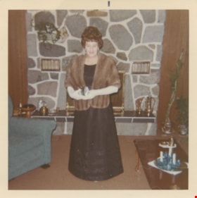
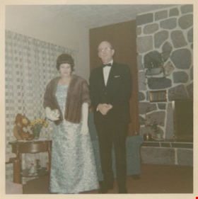
Edith Fountain
https://search.heritageburnaby.ca/link/museumdescription1698
- Repository
- Burnaby Village Museum
- Date
- 1966
- Collection/Fonds
- Burnaby Village Museum Photograph collection
- Description Level
- Item
- Physical Description
- 1 photograph : col. ; 8 x 8 cm
- Scope and Content
- Photograph of Edith Ford Fountain dressed in formal wear in front of the stone fireplace in her living room. She is dressed to attend an Royal Canadian Mounted Police ball in a long black gown with a fur stole and white evening gloves. Her husband Edward Fountain was the first City of Burnaby Licen…
- Repository
- Burnaby Village Museum
- Collection/Fonds
- Burnaby Village Museum Photograph collection
- Description Level
- Item
- Physical Description
- 1 photograph : col. ; 8 x 8 cm
- Scope and Content
- Photograph of Edith Ford Fountain dressed in formal wear in front of the stone fireplace in her living room. She is dressed to attend an Royal Canadian Mounted Police ball in a long black gown with a fur stole and white evening gloves. Her husband Edward Fountain was the first City of Burnaby License Inspector in 1949 (he worked for the City until he retired in 1970).
- History
- Edward and Edith Fountain purchased a home in the Deer Lake area in 1951. 6661 Russel Ave., Burnaby, also know as Moorcroft, was purchased from the builder, Arthur Moore. Edward Fountain was the first City of Burnaby License Inspector in 1949, in 1952 he became the Personnel Director, when he retired in 1970 his position was Assistant Manager. Edward and Edith, who loved to dance, attended many social events, parties and balls due to Edward's positions within the City of Burnaby.
- Names
- Fountain, Edith Ford
- Geographic Access
- Russell Avenue
- Street Address
- 6661 Russell Avenue
- Accession Code
- BV004.17.24
- Access Restriction
- Restricted access
- Reproduction Restriction
- May be restricted by third party rights
- Date
- 1966
- Media Type
- Photograph
- Planning Study Area
- Windsor Area
- Related Material
- The dress and the fur stole Edith Fountain is wearing in the photograph is in BVM collection. BV004.17.2 & BV004.17.3
- Scan Resolution
- 600
- Scan Date
- 09-Jun-09
- Scale
- 100
- Notes
- Title based on contents of photograph
- Note in blue ink on verso of photograph reads:"1966 RCMP BALL."
Images


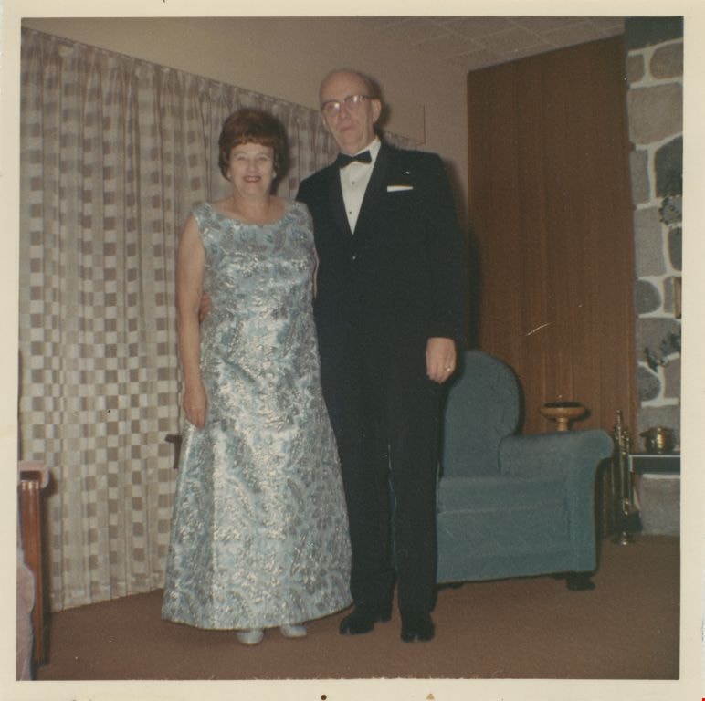
Edward and Edith Fountain
https://search.heritageburnaby.ca/link/museumdescription1696
- Repository
- Burnaby Village Museum
- Date
- 1967
- Collection/Fonds
- Burnaby Village Museum Photograph collection
- Description Level
- Item
- Physical Description
- 1 photograph : col. ; 8 x 8 cm
- Scope and Content
- Photograph of Edward and Edith Fountain dressed in formal wear in front of the stone fireplace in their living room. They are dressed to attend an Royal Canadian Mounted Police ball. Edith is wearing a blue and silver sleeveless dress and her husband Edward is wearing a black suit with a black bow …
- Repository
- Burnaby Village Museum
- Collection/Fonds
- Burnaby Village Museum Photograph collection
- Description Level
- Item
- Physical Description
- 1 photograph : col. ; 8 x 8 cm
- Scope and Content
- Photograph of Edward and Edith Fountain dressed in formal wear in front of the stone fireplace in their living room. They are dressed to attend an Royal Canadian Mounted Police ball. Edith is wearing a blue and silver sleeveless dress and her husband Edward is wearing a black suit with a black bow tie. Edward Fountain was the first City of Burnaby License Inspector in 1949 (he worked for the City until he retired in 1970).
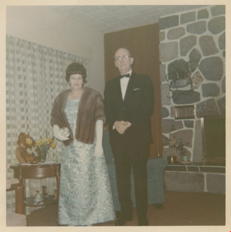
- History
- Edward and Edith Fountain purchased a home in the Deer Lake area in 1951. 6661 Russel Ave., Burnaby, also know as Moorcroft, was purchased from the builder, Arthur Moore. Edward Fountain was the first City of Burnaby License Inspector in 1949, in 1952 he became the Personnel Director, when he retired in 1970 his position was Assistant Manager. Edward and Edith, who loved to dance, attended many social events, parties and balls due to Edward's positions within the City of Burnaby.
- Subjects
- Occupations - Civic Workers
- Geographic Access
- Russell Avenue
- Street Address
- 6661 Russell Avenue
- Accession Code
- BV004.17.22
- Access Restriction
- Restricted access
- Reproduction Restriction
- May be restricted by third party rights
- Date
- 1967
- Media Type
- Photograph
- Planning Study Area
- Windsor Area
- Related Material
- The dress Edith Fountain is wearing in the photograph is in BVM collection. BV004.17.1
- Scan Resolution
- 600
- Scan Date
- 09-Jun-09
- Scale
- 100
- Notes
- Title based on contents of photograph
- Note in blue ink on verso of photograph reads: "1967 RCMP Ball/ 6661 Russell Avenue/ Burnaby"
- Item no. BV004.17.1 is the dress itself
Images
Edward and Edith Fountain
https://search.heritageburnaby.ca/link/museumdescription1697
- Repository
- Burnaby Village Museum
- Date
- 1967
- Collection/Fonds
- Burnaby Village Museum Photograph collection
- Description Level
- Item
- Physical Description
- 1 photograph : col. ; 8 x 8 cm
- Scope and Content
- Photograph of Edward and Edith Fountain dressed in formal wear in front of the stone fireplace in their living room. They are dressed to attend an Royal Canadian Mounted Police ball. Edith is wearing a blue and silver sleeveless dress with a fur stole and white evening gloves. Her husband Edward is…
- Repository
- Burnaby Village Museum
- Collection/Fonds
- Burnaby Village Museum Photograph collection
- Description Level
- Item
- Physical Description
- 1 photograph : col. ; 8 x 8 cm
- Scope and Content
- Photograph of Edward and Edith Fountain dressed in formal wear in front of the stone fireplace in their living room. They are dressed to attend an Royal Canadian Mounted Police ball. Edith is wearing a blue and silver sleeveless dress with a fur stole and white evening gloves. Her husband Edward is wearing a black suit with a black bow tie. Edward Fountain was the first City of Burnaby License Inspector in 1949 (he worked for the City until he retired in 1970).
- Subjects
- Occupations - Civic Workers
- Geographic Access
- Russell Avenue
- Street Address
- 6661 Russell Avenue
- Accession Code
- BV004.17.23
- Access Restriction
- Restricted access
- Reproduction Restriction
- May be restricted by third party rights
- Date
- 1967
- Media Type
- Photograph
- Planning Study Area
- Windsor Area
- Related Material
- The dress and the fur stole Edith Fountain is wearing in the photograph are in BVM collection. BV004.17.1 & BV004.17.3
- Scan Resolution
- 600
- Scan Date
- 09-Jun-09
- Scale
- 100
- Notes
- Title based on contents of photograph
- Note in blue ink on verso of photograph reads: "1967"
- Item no. BV004.17.1 is the dress itself
Images

Kingsview Apartments
https://search.heritageburnaby.ca/link/archivedescription98669
- Repository
- City of Burnaby Archives
- Date
- 2022
- Collection/Fonds
- Disappearing Burnaby collection
- Description Level
- Item
- Physical Description
- 1 photograph (jpeg) : col.
- Scope and Content
- Photograph of the entrance and exterior of Kingsview Apartments, an apartment building located at 6187 Kingsway. The photograph depicts the building at night and in the rain. The hallways and stairwells of the three-storey apartment building are illuminated. The building was constructed in 1977.
- Repository
- City of Burnaby Archives
- Date
- 2022
- Collection/Fonds
- Disappearing Burnaby collection
- Physical Description
- 1 photograph (jpeg) : col.
- Description Level
- Item
- Record No.
- 634-016
- Access Restriction
- No restrictions
- Reproduction Restriction
- No restrictions
- Accession Number
- 2022-14
- Scope and Content
- Photograph of the entrance and exterior of Kingsview Apartments, an apartment building located at 6187 Kingsway. The photograph depicts the building at night and in the rain. The hallways and stairwells of the three-storey apartment building are illuminated. The building was constructed in 1977.
- Media Type
- Photograph
- Photographer
- Cheung, Nakita
- Notes
- Title taken from the associated blog post
- Associated blog post: https://disappearingburnaby.wordpress.com/2022/06/01/oasis/
- Geographic Access
- Kingsway
- Street Address
- 6187 Kingsway
- Historic Neighbourhood
- Central Park (Historic Neighbourhood)
- Planning Study Area
- Windsor Area
Images

![Mike and Dennis Krewenchuk, [between 1958 and 196-] thumbnail](/media/hpo/_Data/_Archives_Images/_Unrestricted/580/582-002.jpg?width=280)
Mike and Dennis Krewenchuk
https://search.heritageburnaby.ca/link/archivedescription88413
- Repository
- City of Burnaby Archives
- Date
- [between 1958 and 196-]
- Collection/Fonds
- Krewenchuk family fonds
- Description Level
- Item
- Physical Description
- 1 photograph : b&w ; 9 x 13 cm
- Scope and Content
- Photograph of Mike (father) and Dennis (son) Krewenchuk seated on the flower bed of the Nelson Motel (also known as the Nelson Auto Court and Nelson Bungalow Court). The stairs to the motel office can be seen to the left with the wall of the building in behind them. The building served as the Krewe…
- Repository
- City of Burnaby Archives
- Date
- [between 1958 and 196-]
- Collection/Fonds
- Krewenchuk family fonds
- Physical Description
- 1 photograph : b&w ; 9 x 13 cm
- Description Level
- Item
- Record No.
- 582-002
- Access Restriction
- No restrictions
- Reproduction Restriction
- May be restricted by third party rights
- Accession Number
- 2015-05
- Scope and Content
- Photograph of Mike (father) and Dennis (son) Krewenchuk seated on the flower bed of the Nelson Motel (also known as the Nelson Auto Court and Nelson Bungalow Court). The stairs to the motel office can be seen to the left with the wall of the building in behind them. The building served as the Krewenchuk family home and business office and was located at 6550 Nelson Avenue. Michael and his wife Mary owned the business and property between 1957 and 1967, while raising their son Dennis.
- Media Type
- Photograph
- Notes
- Title based on contents of photograph
- Street Address
- 6550 Nelson Avenue
- Historic Neighbourhood
- Central Park (Historic Neighbourhood)
- Planning Study Area
- Windsor Area
Images
![Mike and Dennis Krewenchuk, [between 1958 and 196-] thumbnail](/media/hpo/_Data/_Archives_Images/_Unrestricted/580/582-002.jpg)
![Nelson Bungalow Court, [between 1958 and 196-] thumbnail](/media/hpo/_Data/_Archives_Images/_Unrestricted/580/582-001.jpg?width=280)
Nelson Bungalow Court
https://search.heritageburnaby.ca/link/archivedescription88412
- Repository
- City of Burnaby Archives
- Date
- [between 1958 and 196-]
- Collection/Fonds
- Krewenchuk family fonds
- Description Level
- Item
- Physical Description
- 1 photograph : b&w ; 8 x 11.5 cm
- Scope and Content
- Photograph of the Nelson Bungalow Court (also known as The Nelson Motel and The Nelson Auto Court) located at 6550 Nelson Avenue. The motel was owned and operated by Michael and Mary Krewenchuk between 1957 to 1967. The building in the photo was the family home and office for the motel on one acre …
- Repository
- City of Burnaby Archives
- Date
- [between 1958 and 196-]
- Collection/Fonds
- Krewenchuk family fonds
- Physical Description
- 1 photograph : b&w ; 8 x 11.5 cm
- Description Level
- Item
- Record No.
- 582-001
- Access Restriction
- No restrictions
- Reproduction Restriction
- May be restricted by third party rights
- Accession Number
- 2015-05
- Scope and Content
- Photograph of the Nelson Bungalow Court (also known as The Nelson Motel and The Nelson Auto Court) located at 6550 Nelson Avenue. The motel was owned and operated by Michael and Mary Krewenchuk between 1957 to 1967. The building in the photo was the family home and office for the motel on one acre of land with eight cabins and seven trailors for lease. Lobely Park was located behind the house on adjacent property. The house is surrounded by trees including a monkey puzzle tree standing in front near a lampost with a totem pole design.
- Media Type
- Photograph
- Notes
- Title based on contents of photograph
- Street Address
- 6550 Nelson Avenue
- Historic Neighbourhood
- Central Park (Historic Neighbourhood)
- Planning Study Area
- Windsor Area
Images
![Nelson Bungalow Court, [between 1958 and 196-] thumbnail](/media/hpo/_Data/_Archives_Images/_Unrestricted/580/582-001.jpg)

No playing here
https://search.heritageburnaby.ca/link/archivedescription95110
- Repository
- City of Burnaby Archives
- Date
- April 24, 2020
- Collection/Fonds
- Burnaby Photographic Society fonds
- Description Level
- Item
- Physical Description
- 1 photograph (tiff)
- Scope and Content
- Photograph of playground equipment taped off with caution tape at Royal Oakland Park. A red City of Burnaby facility closure sign posted to the playground is visible through the top of a slide.
- Repository
- City of Burnaby Archives
- Date
- April 24, 2020
- Collection/Fonds
- Burnaby Photographic Society fonds
- Physical Description
- 1 photograph (tiff)
- Description Level
- Item
- Record No.
- 623-028
- Access Restriction
- No restrictions
- Reproduction Restriction
- No restrictions
- Accession Number
- 2020-10
- Scope and Content
- Photograph of playground equipment taped off with caution tape at Royal Oakland Park. A red City of Burnaby facility closure sign posted to the playground is visible through the top of a slide.
- Media Type
- Photograph
- Photographer
- Snowdon, Nick
- Notes
- Transcribed title
- Photographer's caption: "Most playgrounds are taped off"
- Geographic Access
- Oakmount Crescent
- Historic Neighbourhood
- Central Park (Historic Neighbourhood)
- Planning Study Area
- Windsor Area
Images


On On Wonton House
https://search.heritageburnaby.ca/link/archivedescription98670
- Repository
- City of Burnaby Archives
- Date
- 2022
- Collection/Fonds
- Disappearing Burnaby collection
- Description Level
- Item
- Physical Description
- 1 photograph (jpeg) : col.
- Scope and Content
- Photograph of the exterior of the On On Wonton House restaurant, located at 5640 Kingsway. The photograph is taken from across Kingsway at night. The building, which was constructed in 1959, is lit up with lights and a bright sign, and several cars are parked in the lot in front of the restaurant.
- Repository
- City of Burnaby Archives
- Date
- 2022
- Collection/Fonds
- Disappearing Burnaby collection
- Physical Description
- 1 photograph (jpeg) : col.
- Description Level
- Item
- Record No.
- 634-017
- Access Restriction
- No restrictions
- Reproduction Restriction
- No restrictions
- Accession Number
- 2022-14
- Scope and Content
- Photograph of the exterior of the On On Wonton House restaurant, located at 5640 Kingsway. The photograph is taken from across Kingsway at night. The building, which was constructed in 1959, is lit up with lights and a bright sign, and several cars are parked in the lot in front of the restaurant.
- Media Type
- Photograph
- Photographer
- Cheung, Nakita
- Notes
- Title taken from the associated blog post
- Associated blog post: https://disappearingburnaby.wordpress.com/2022/06/06/on-on-wonton-house/
- Geographic Access
- Kingsway
- Street Address
- 5640 Kingsway
- Historic Neighbourhood
- Central Park (Historic Neighbourhood)
- Planning Study Area
- Windsor Area
Images
