Narrow Results By
Subject
- Advertising Medium - Signs and Signboards 1
- Agriculture - Farms 2
- Agriculture - Fruit and Berries 2
- Animals - Cows 1
- Animals - Dogs 1
- Animals - Goats 2
- Animals - Poultry 2
- Buildings - Agricultural 1
- Buildings - Agricultural - Barns 1
- Buildings - Commercial - Restaurants 4
- Buildings - Commercial - Train Stations 1
- Buildings - Residential - Cabins 1
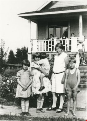
Bellinger and Baker children
https://search.heritageburnaby.ca/link/archivedescription35166
- Repository
- City of Burnaby Archives
- Date
- 1929 (date of original), copied 1986
- Collection/Fonds
- Burnaby Historical Society fonds
- Description Level
- Item
- Physical Description
- 1 photograph : b&w ; 12.7 x 17.8 cm print
- Scope and Content
- Photograph of Bellinger children and friends. From left: Marion Bellinger, Christine Bellinger holding Robert "Bob" Bellinger, and two Baker children. Taken in front of Bellinger home at 6296 Earl Avenue, now called Pearl Avenue. Note the plank sidewalk.
- Repository
- City of Burnaby Archives
- Date
- 1929 (date of original), copied 1986
- Collection/Fonds
- Burnaby Historical Society fonds
- Subseries
- Pioneer Tales subseries
- Physical Description
- 1 photograph : b&w ; 12.7 x 17.8 cm print
- Description Level
- Item
- Record No.
- 204-023
- Access Restriction
- No restrictions
- Reproduction Restriction
- No known restrictions
- Accession Number
- BHS1988-03
- Scope and Content
- Photograph of Bellinger children and friends. From left: Marion Bellinger, Christine Bellinger holding Robert "Bob" Bellinger, and two Baker children. Taken in front of Bellinger home at 6296 Earl Avenue, now called Pearl Avenue. Note the plank sidewalk.
- Media Type
- Photograph
- Notes
- Title based on contents of photograph
- Geographic Access
- Pearl Avenue
- Street Address
- 6296 Earl Avenue
- Historic Neighbourhood
- Central Park (Historic Neighbourhood)
- Planning Study Area
- Windsor Area
Images

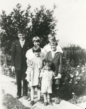
Bellinger family
https://search.heritageburnaby.ca/link/archivedescription35167
- Repository
- City of Burnaby Archives
- Date
- 1929 (date of original), copied 1986
- Collection/Fonds
- Burnaby Historical Society fonds
- Description Level
- Item
- Physical Description
- 1 photograph : b&w ; 12.7 x 17.8 cm print
- Scope and Content
- Photograph of the Bellinger family children. Back row: Bernard Bellinger, Christine Bellinger and David Bellinger. Middle row: Marion Bellinger and James Bellinger. Front row: Robert "Bob" Bellinger. Taken in front of the Bellinger family home at 6296 Earl Avenue, now called Pearl Avenue.
- Repository
- City of Burnaby Archives
- Date
- 1929 (date of original), copied 1986
- Collection/Fonds
- Burnaby Historical Society fonds
- Subseries
- Pioneer Tales subseries
- Physical Description
- 1 photograph : b&w ; 12.7 x 17.8 cm print
- Description Level
- Item
- Record No.
- 204-024
- Access Restriction
- No restrictions
- Reproduction Restriction
- No known restrictions
- Accession Number
- BHS1988-03
- Scope and Content
- Photograph of the Bellinger family children. Back row: Bernard Bellinger, Christine Bellinger and David Bellinger. Middle row: Marion Bellinger and James Bellinger. Front row: Robert "Bob" Bellinger. Taken in front of the Bellinger family home at 6296 Earl Avenue, now called Pearl Avenue.
- Names
- Bellinger, Bernard
- Bellinger, Christine
- Bellinger, David
- Bellinger, James
- Bellinger, Marion
- Bellinger, Robert "Bob"
- Media Type
- Photograph
- Notes
- Title based on contents of photograph
- Geographic Access
- Pearl Avenue
- Street Address
- 6296 Earl Avenue
- Historic Neighbourhood
- Central Park (Historic Neighbourhood)
- Planning Study Area
- Windsor Area
Images

Florence McMahon
https://search.heritageburnaby.ca/link/archivedescription35262
- Repository
- City of Burnaby Archives
- Date
- 1929 (date of original), copied 1986
- Collection/Fonds
- Burnaby Historical Society fonds
- Description Level
- Item
- Physical Description
- 1 photograph : b&w ; 12.7 x 17.8 cm print
- Scope and Content
- Photograph of Florence McMahon, daughter of Florence Bookey McMahon and James McMahon, wearing beach pyjamas, the fashion of the day. She is feeding pet ducks who were hatched by the hen in the background. She is on the McMahon property on Waltham Avenue, later numbered 6558 Waltham Avenue.
- Repository
- City of Burnaby Archives
- Date
- 1929 (date of original), copied 1986
- Collection/Fonds
- Burnaby Historical Society fonds
- Subseries
- Pioneer Tales subseries
- Physical Description
- 1 photograph : b&w ; 12.7 x 17.8 cm print
- Description Level
- Item
- Record No.
- 204-119
- Access Restriction
- No restrictions
- Reproduction Restriction
- No known restrictions
- Accession Number
- BHS1988-03
- Scope and Content
- Photograph of Florence McMahon, daughter of Florence Bookey McMahon and James McMahon, wearing beach pyjamas, the fashion of the day. She is feeding pet ducks who were hatched by the hen in the background. She is on the McMahon property on Waltham Avenue, later numbered 6558 Waltham Avenue.
- Subjects
- Clothing
- Animals - Poultry
- Names
- McMahon, Florence
- Media Type
- Photograph
- Notes
- Title based on contents of photograph
- Geographic Access
- Waltham Avenue
- Street Address
- 6558 Waltham Avenue
- Historic Neighbourhood
- Central Park (Historic Neighbourhood)
- Planning Study Area
- Windsor Area
Images

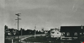
Davis family neighbourhood
https://search.heritageburnaby.ca/link/archivedescription35610
- Repository
- City of Burnaby Archives
- Date
- 1929 (date of original), copied 1986
- Collection/Fonds
- Burnaby Historical Society fonds
- Description Level
- Item
- Physical Description
- 1 photograph : b&w ; 10.2 x 17.8 cm print
- Scope and Content
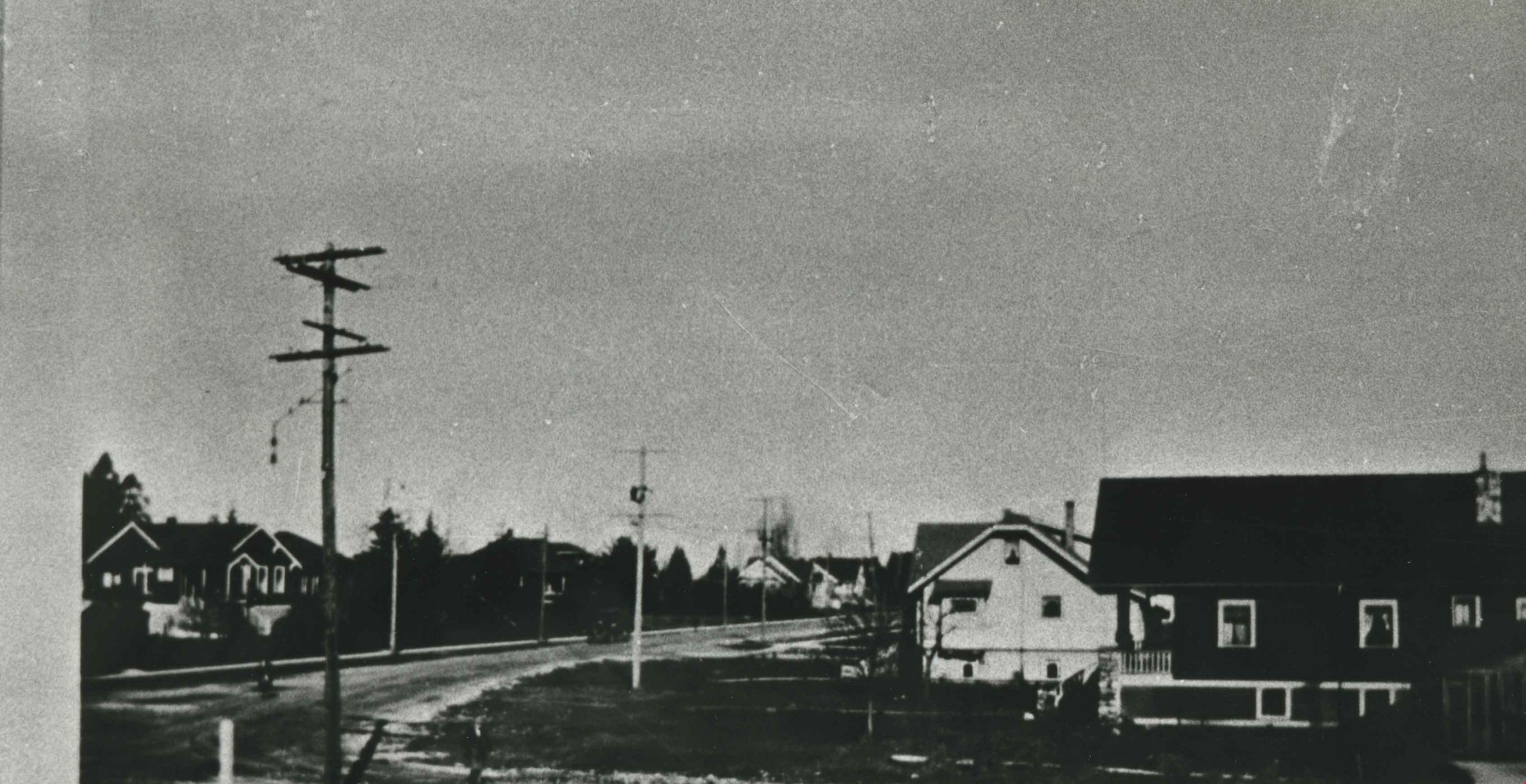
- Photograph of the neighbourhood where the Davis family lived, looking up Royal Oak Road at Imperial Street, taken from an upstairs room of the Davis home. Arthur Davis later built a corner house at 2345 Royal Oak, right next to house from which this photograph was taken.
- Repository
- City of Burnaby Archives
- Date
- 1929 (date of original), copied 1986
- Collection/Fonds
- Burnaby Historical Society fonds
- Subseries
- Pioneer Tales subseries
- Physical Description
- 1 photograph : b&w ; 10.2 x 17.8 cm print
- Description Level
- Item
- Record No.
- 204-468
- Access Restriction
- No restrictions
- Reproduction Restriction
- No known restrictions
- Accession Number
- BHS1988-03
- Scope and Content
- Photograph of the neighbourhood where the Davis family lived, looking up Royal Oak Road at Imperial Street, taken from an upstairs room of the Davis home. Arthur Davis later built a corner house at 2345 Royal Oak, right next to house from which this photograph was taken.
- Subjects
- Geographic Features - Neighbourhoods
- Media Type
- Photograph
- Notes
- Title based on contents of photograph
- Photograph has been cropped
- Geographic Access
- Royal Oak Avenue
- Historic Neighbourhood
- Central Park (Historic Neighbourhood)
- Planning Study Area
- Windsor Area
Images
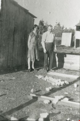
Oasis Tourist Camp cabins
https://search.heritageburnaby.ca/link/archivedescription35627
- Repository
- City of Burnaby Archives
- Date
- 1929 (date of original), copied 1986
- Collection/Fonds
- Burnaby Historical Society fonds
- Description Level
- Item
- Physical Description
- 1 photograph : b&w ; 12.7 x 17.8 cm print
- Scope and Content
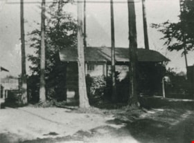
- Photograph of the first of ten rental cabins built at The Oasis tourist camp. The Oasis was located at 2675 Kingsway (Pacific Highway). It was later renumbered 6105 Kingsway.
- Repository
- City of Burnaby Archives
- Date
- 1929 (date of original), copied 1986
- Collection/Fonds
- Burnaby Historical Society fonds
- Subseries
- Pioneer Tales subseries
- Physical Description
- 1 photograph : b&w ; 12.7 x 17.8 cm print
- Description Level
- Item
- Record No.
- 204-485
- Access Restriction
- No restrictions
- Reproduction Restriction
- No known restrictions
- Accession Number
- BHS1988-03
- Scope and Content
- Photograph of the first of ten rental cabins built at The Oasis tourist camp. The Oasis was located at 2675 Kingsway (Pacific Highway). It was later renumbered 6105 Kingsway.
- Names
- Oasis
- Media Type
- Photograph
- Notes
- Title based on contents of photograph
- Geographic Access
- Kingsway
- Street Address
- 6105 Kingsway
- Planning Study Area
- Windsor Area
Images
![Bellinger and Baker children, [1929 or 1930] (date of original), copied 1991 thumbnail](/media/hpo/_Data/_Archives_Images/_Unrestricted/370/370-063.jpg?width=280)
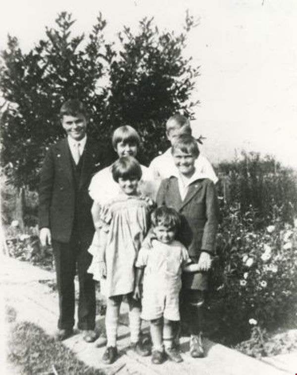
Bellinger and Baker children
https://search.heritageburnaby.ca/link/archivedescription37475
- Repository
- City of Burnaby Archives
- Date
- [1929 or 1930] (date of original), copied 1991
- Collection/Fonds
- Burnaby Historical Society fonds
- Description Level
- Item
- Physical Description
- 1 photograph : b&w ; 4.4 x 3.0 cm print on contact sheet 20.2 x 25.3 cm
- Scope and Content
- Photograph of five children standing on the board sidewalk in front of 2827 Earl Avenue (later 6296 Pearl Avenue). Left to right: Marion Bellinger, Christine Bellinger, Robert Bellinger, Barbara Baker, and Barbara's sister. Adults are seated on the porch behind them.
- Repository
- City of Burnaby Archives
- Date
- [1929 or 1930] (date of original), copied 1991
- Collection/Fonds
- Burnaby Historical Society fonds
- Subseries
- Burnaby Image Bank subseries
- Physical Description
- 1 photograph : b&w ; 4.4 x 3.0 cm print on contact sheet 20.2 x 25.3 cm
- Description Level
- Item
- Record No.
- 370-063
- Access Restriction
- No restrictions
- Reproduction Restriction
- Reproduce for fair dealing purposes only
- Accession Number
- BHS1999-03
- Scope and Content
- Photograph of five children standing on the board sidewalk in front of 2827 Earl Avenue (later 6296 Pearl Avenue). Left to right: Marion Bellinger, Christine Bellinger, Robert Bellinger, Barbara Baker, and Barbara's sister. Adults are seated on the porch behind them.
- Media Type
- Photograph
- Photographer
- Bellinger, Bernard
- Notes
- Title based on contents of photograph
- 1 b&w copy negative accompanying
- Geographic Access
- Pearl Avenue
- Street Address
- 6296 Pearl Avenue
- Historic Neighbourhood
- Central Park (Historic Neighbourhood)
- Planning Study Area
- Windsor Area
Images
![Bellinger and Baker children, [1929 or 1930] (date of original), copied 1991 thumbnail](/media/hpo/_Data/_Archives_Images/_Unrestricted/370/370-063.jpg)
Burnaby South Secondary School yearbook : 1928-1929
https://search.heritageburnaby.ca/link/museumlibrary5329
- Repository
- Burnaby Village Museum
- Collection
- Special Collection
- Material Type
- Book
- Accession Code
- BV005.79.2
- Call Number
- 373.71 BUR 1929
- Place of Publication
- Burnaby, B.C.
- Publisher
- Burnaby South Secondary School
- Publication Date
- 1929
- Printer
- Ward & Phillips
- Physical Description
- 59 p. : ill., ports. ; 26 cm.
- Library Subject (LOC)
- School yearbooks--1920-1929
- Schools--British Columbia--Burnaby
- School yearbooks
- Historic Neighbourhood
- Central Park (Historic Neighbourhood)
- Planning Study Area
- Windsor Area
- Geographic Access
- Rumble Street
- Street Address
- 5455 Rumble Street
- Notes
- High school annual for South Burnaby High School

Burnaby South Secondary School yearbook : 1928-1929
https://search.heritageburnaby.ca/link/museumlibrary7510
- Repository
- Burnaby Village Museum
- Collection
- Special Collection
- Material Type
- Book
- Accession Code
- BV020.7.3
- Call Number
- 373.71 BUR 1929
- Place of Publication
- Burnaby, B.C.
- Publisher
- Burnaby South Secondary School
- Publication Date
- 1929
- Printer
- Ward & Phillips
- Physical Description
- 60 p. : ill., ports. ; 26 cm.
- Library Subject (LOC)
- School yearbooks--1920-1929
- Schools--British Columbia--Burnaby
- School yearbooks
- Historic Neighbourhood
- Central Park (Historic Neighbourhood)
- Planning Study Area
- Windsor Area
- Geographic Access
- Rumble Street
- Street Address
- 5455 Rumble Street
- Object History
- This yearbook belonged to Lauretta Roberts.
- Notes
- High school annual for South Burnaby High School
Images

Sellers family home
https://search.heritageburnaby.ca/link/archivedescription35237
- Repository
- City of Burnaby Archives
- Date
- 1928 (date of original), copied 1986
- Collection/Fonds
- Burnaby Historical Society fonds
- Description Level
- Item
- Physical Description
- 1 photograph : b&w ; 12.7 x 17.8 cm print
- Scope and Content
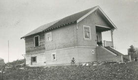
- Photograph of the completed Sellers family home at 3130 Princess Street (later 5680 Lane Street) which was finished in 1928. The home was built by Harry Sellers from 1923-1928. The family lived in the front portion while still working on the rest of the house.
- Repository
- City of Burnaby Archives
- Date
- 1928 (date of original), copied 1986
- Collection/Fonds
- Burnaby Historical Society fonds
- Subseries
- Pioneer Tales subseries
- Physical Description
- 1 photograph : b&w ; 12.7 x 17.8 cm print
- Description Level
- Item
- Record No.
- 204-094
- Access Restriction
- No restrictions
- Reproduction Restriction
- No known restrictions
- Accession Number
- BHS1988-03
- Scope and Content
- Photograph of the completed Sellers family home at 3130 Princess Street (later 5680 Lane Street) which was finished in 1928. The home was built by Harry Sellers from 1923-1928. The family lived in the front portion while still working on the rest of the house.
- Subjects
- Buildings - Residential - Houses
- Media Type
- Photograph
- Notes
- Title based on contents of photograph
- Geographic Access
- Lane Street
- Street Address
- 5680 Lane Street
- Historic Neighbourhood
- Central Park (Historic Neighbourhood)
- Planning Study Area
- Windsor Area
Images

McMahon chickens
https://search.heritageburnaby.ca/link/archivedescription35261
- Repository
- City of Burnaby Archives
- Date
- 1928 (date of original), copied 1986
- Collection/Fonds
- Burnaby Historical Society fonds
- Description Level
- Item
- Physical Description
- 1 photograph : b&w ; 12.7 x 17.8 cm print
- Scope and Content
- Photograph of baby chicks on the McMahon property on Waltham Avenue, later numbered 6558 Waltham Avenue. A woman and man are standing behind them.
- Repository
- City of Burnaby Archives
- Date
- 1928 (date of original), copied 1986
- Collection/Fonds
- Burnaby Historical Society fonds
- Subseries
- Pioneer Tales subseries
- Physical Description
- 1 photograph : b&w ; 12.7 x 17.8 cm print
- Description Level
- Item
- Record No.
- 204-118
- Access Restriction
- No restrictions
- Reproduction Restriction
- No known restrictions
- Accession Number
- BHS1988-03
- Scope and Content
- Photograph of baby chicks on the McMahon property on Waltham Avenue, later numbered 6558 Waltham Avenue. A woman and man are standing behind them.
- Subjects
- Animals - Poultry
- Media Type
- Photograph
- Notes
- Title based on contents of photograph
- Geographic Access
- Waltham Avenue
- Street Address
- 6558 Waltham Avenue
- Historic Neighbourhood
- Central Park (Historic Neighbourhood)
- Planning Study Area
- Windsor Area
Images


Painting Centre Line on Kingsway
https://search.heritageburnaby.ca/link/museumdescription65
- Repository
- Burnaby Village Museum
- Date
- 1928 (date of original), copied 1971
- Collection/Fonds
- Burnaby Village Museum Photograph collection
- Description Level
- Item
- Physical Description
- 1 photograph : b&w ; 15.0 x 25.2 cm print
- Scope and Content
- Photograph of Frank Warburton sitting backwards on a plank attached to the front of a car, as it is being driven. The make of the car is unidentified, but has wooden spoked wheels, running boards, and a soft convertible top. Mr. Warburton is painting the centre line on Kingsway. The photograph is…
- Repository
- Burnaby Village Museum
- Collection/Fonds
- Burnaby Village Museum Photograph collection
- Description Level
- Item
- Physical Description
- 1 photograph : b&w ; 15.0 x 25.2 cm print
- Scope and Content
- Photograph of Frank Warburton sitting backwards on a plank attached to the front of a car, as it is being driven. The make of the car is unidentified, but has wooden spoked wheels, running boards, and a soft convertible top. Mr. Warburton is painting the centre line on Kingsway. The photograph is taken 1928 at corner of Grimmer and Kingsway. In the background of the photograph, to the left, there are residential houses with a parked car, and to the right, is a tall gas pump.
- Names
- Warburton, Frank
- Geographic Access
- Kingsway
- Grimmer Street
- Accession Code
- HV971.173.1
- Access Restriction
- No restrictions
- Reproduction Restriction
- No known restrictions
- Date
- 1928 (date of original), copied 1971
- Media Type
- Photograph
- Historic Neighbourhood
- Central Park (Historic Neighbourhood)
- Planning Study Area
- Windsor Area
- Scan Resolution
- 600
- Scan Date
- 2023-03-28
- Notes
- Title based on contents of photograph
- The information in scope and content taken from earlier catalgue record from 1976, and verified by various accession and donation paperworks
Images

Burnaby South Secondary School yearbook : 1927-1928
https://search.heritageburnaby.ca/link/museumlibrary5328
- Repository
- Burnaby Village Museum
- Collection
- Special Collection
- Material Type
- Book
- Accession Code
- BV005.79.1
- Call Number
- 373.71 BUR 1928
- Place of Publication
- Burnaby, B.C.
- Publisher
- Burnaby South Secondary School
- Publication Date
- 1928
- Printer
- Lionel Ward & Co. Ltd.
- Physical Description
- 48 p. : ill., ports. ; 16 x 23 cm.
- Library Subject (LOC)
- School yearbooks--1920-1929
- Schools--British Columbia--Burnaby
- School yearbooks
- Historic Neighbourhood
- Central Park (Historic Neighbourhood)
- Planning Study Area
- Windsor Area
- Geographic Access
- Rumble Street
- Street Address
- 5455 Rumble Street
- Notes
- High school annual for South Burnaby High School

Municipality of Burnaby - Volume XVIII and Volume XIX
https://search.heritageburnaby.ca/link/museumdescription8683
- Repository
- Burnaby Village Museum
- Date
- May 1927
- Collection/Fonds
- Burnaby Village Museum Map collection
- Description Level
- File
- Physical Description
- 2 plans on 2 sheets : col. lithographic prints ; 63.5 x 53.5 cm folded to 53 x 31.5 cm
- Scope and Content
- File consists of two pages of plans removed from a bound book containing a series of fire insurance plans of the Municipality of Burnaby. Plan "1832" is from "GREATER VANCOUVER B.C. / VOLUME XVIII / Municipality of Burnaby / May, 1927" and covers District Lots: 98 and 28. Plan "K" is part of a key …
- Repository
- Burnaby Village Museum
- Collection/Fonds
- Burnaby Village Museum Map collection
- Description Level
- File
- Physical Description
- 2 plans on 2 sheets : col. lithographic prints ; 63.5 x 53.5 cm folded to 53 x 31.5 cm
- Material Details
- Scale [1:1200] to [1:6000]
- Scope and Content
- File consists of two pages of plans removed from a bound book containing a series of fire insurance plans of the Municipality of Burnaby. Plan "1832" is from "GREATER VANCOUVER B.C. / VOLUME XVIII / Municipality of Burnaby / May, 1927" and covers District Lots: 98 and 28. Plan "K" is part of a key plan "GREATER VANCOUVER B.C. / Surveyed VOLUME XIX May 1927 / MUNICIPALITY OF / BURNABY / PLAN DEPT. British Columbia Ins. Underwriters Association / FIRE BRANCH / KEY PLAN", "Scale 500 FT = 1 INCH / FOR REPORT SEE VOL. XV" covering plans: 1901 to 1914 and District Lots: 161; 164 to 167; 155c; 155; 172 and 173.
- Responsibility
- British Columbia Underwriters' Association
- Accession Code
- HV972.111.5
- Access Restriction
- No restrictions
- Reproduction Restriction
- May be restricted by third party rights
- Date
- May 1927
- Media Type
- Cartographic Material
- Historic Neighbourhood
- East Burnaby (Historic Neighbourhood)
- Central Park (Historic Neighbourhood)
- Fraser Arm (Historic Neighbourhood)
- Alta Vista (Historic Neighbourhood)
- Planning Study Area
- Windsor Area
- Marlborough Area
- Second Street Area
- Big Bend Area
- Sussex-Nelson Area
- Scan Resolution
- 400
- Scan Date
- 2021-11-18
- Notes
- Title based on content of plans
- See also BV987.1.70d for revised versions of plans
- Scale is measured 1 inch = 500 feet
Zoomable Images


Municipality of Burnaby - Volume XV, Volume XVI, Volume XVII, Volume XVIII
https://search.heritageburnaby.ca/link/museumdescription8685
- Repository
- Burnaby Village Museum
- Date
- May 1927
- Collection/Fonds
- Burnaby Village Museum Map collection
- Description Level
- File
- Physical Description
- 4 plans on 4 sheets : col. lithographic prints ; 63.5 x 53.5 cm folded to 53 x 31.5 cm
- Scope and Content
- File consists of four pages of plans removed from a bound book containing a series of fire insurance plans of the Municipality of Burnaby. Plan "1531" is part of "GREATER VANCOUVER B.C. / VOLUME XV / Municipality of Burnaby / May 1927" and covers District Lots: 116 and 117. Key Plan "C" is part of …
- Repository
- Burnaby Village Museum
- Collection/Fonds
- Burnaby Village Museum Map collection
- Description Level
- File
- Physical Description
- 4 plans on 4 sheets : col. lithographic prints ; 63.5 x 53.5 cm folded to 53 x 31.5 cm
- Material Details
- Scale [1:600] and [1:1200]
- Scope and Content
- File consists of four pages of plans removed from a bound book containing a series of fire insurance plans of the Municipality of Burnaby. Plan "1531" is part of "GREATER VANCOUVER B.C. / VOLUME XV / Municipality of Burnaby / May 1927" and covers District Lots: 116 and 117. Key Plan "C" is part of "GREATER VANCOUVER B.C. / VOLUME XVI / Municipality of Burnaby / May 1927" and covers plans 1623 to 1651 and District Lots: 1 and 2; 4; 6; 8; 10 to 14; 25; 27; 40; 56 to 58; 88 and 89. Plan "1738" is part of "GREATER VANCOUVER B.C. / VOLUME XVII / Municipality of Burnaby / May 1927" and covers District Lots: 34 and 35. Key plan "G" is part of "GREATER VANCOUVER B.C. / VOLUME XVIII / Municipality of Burnaby / May 1927" and covers plans: 1801 to 1813; 1823; 1824; 1833 to 1838; 1841 to 1853 and District Lots: 32; 93; 94; 97 to 99; 149; 150; 152; 155 to 159; 161 to 164.
- Responsibility
- British Columbia Underwriters' Association
- Accession Code
- HV972.111.7
- Access Restriction
- No restrictions
- Reproduction Restriction
- May be restricted by third party rights
- Date
- May 1927
- Media Type
- Cartographic Material
- Historic Neighbourhood
- Central Park (Historic Neighbourhood)
- Fraser Arm (Historic Neighbourhood)
- Alta Vista (Historic Neighbourhood)
- Broadview (Historic Neighbourhood)
- Vancouver Heights (Historic Neighbourhood)
- Burquitlam (Historic Neighbourhood)
- East Burnaby (Historic Neighbourhood)
- Edmonds (Historic Neighbourhood)
- Lozells (Historic Neighbourhood)
- Planning Study Area
- Clinton-Glenwood Area
- Marlborough Area
- Maywood Area
- Windsor Area
- Big Bend Area
- Garden Village Area
- Willingdon Heights Area
- West Central Valley Area
- Cariboo-Armstrong Area
- Lyndhurst Area
- Cameron Area
- Lake City Area
- Edmonds Area
- Second Street Area
- Sperling-Broadway Area
- Lakeview-Mayfield Area
- Scan Resolution
- 400
- Scan Date
- 2021-11-18
- Notes
- Title based on content of plans
- See also BV987.1.70d for revised versions of plans
- Scale is measured 1 inch = 500 feet
Zoomable Images

Municipality of Burnaby - Volume XV, Volume XVI, Volume XVII, Volume XVIII, May 1927
Zoom into Image

Municipality of Burnaby- Volume XV and Volume XVIII
https://search.heritageburnaby.ca/link/museumdescription8686
- Repository
- Burnaby Village Museum
- Date
- May 1927
- Collection/Fonds
- Burnaby Village Museum Map collection
- Description Level
- File
- Physical Description
- 4 plans on 4 sheets : col. lithographic prints ; 63.5 x 53.5 cm folded to 53 x 31.5 cm
- Scope and Content
- File consists of four pages of plans removed from a bound book containing a series of fire insurance plans of the Municipality of Burnaby. Plan "1520" is part of "GREATER VANCOUVER B.C. / VOLUME XV / Municipality of Burnaby / May 1927" and covers District Lots: 121 and 187. Plann "1521" is part of …
- Repository
- Burnaby Village Museum
- Collection/Fonds
- Burnaby Village Museum Map collection
- Description Level
- File
- Physical Description
- 4 plans on 4 sheets : col. lithographic prints ; 63.5 x 53.5 cm folded to 53 x 31.5 cm
- Material Details
- Scale [1:600] and [1:1200]
- Scope and Content
- File consists of four pages of plans removed from a bound book containing a series of fire insurance plans of the Municipality of Burnaby. Plan "1520" is part of "GREATER VANCOUVER B.C. / VOLUME XV / Municipality of Burnaby / May 1927" and covers District Lots: 121 and 187. Plann "1521" is part of "GREATER VANCOUVER B.C. / VOLUME XV / Municipality of Burnaby / May 1927" and covers District Lots: 121 and 187. Key plan "H" reads: "GREATER VANCOUVER B.C. / VOLUME XVIII / Surveyed _ May 1927 / MUNICIPALITY OF / BURNABY" and covers plans: 1813 to 1822; 1824 to 1832; 1839; 1840; 1853 to 1865 and District Lots: 28; 30; 53; 90 to 93; 95 to 97; 155a; 155b; 155c; 159; 160; 171 to 173. Plan "1801" is part of "GREATER VANCOUVER B.C. / VOLUME XVIII / Municipality of Burnaby / May 1927" and covers District Lot 153.
- Responsibility
- British Columbia Underwriters' Association
- Accession Code
- HV972.111.8
- Access Restriction
- No restrictions
- Reproduction Restriction
- May be restricted by third party rights
- Date
- May 1927
- Media Type
- Cartographic Material
- Historic Neighbourhood
- Fraser Arm (Historic Neighbourhood)
- Vancouver Heights (Historic Neighbourhood)
- East Burnaby (Historic Neighbourhood)
- Edmonds (Historic Neighbourhood)
- Planning Study Area
- Marlborough Area
- Kingsway-Beresford Area
- Windsor Area
- Big Bend Area
- Clinton-Glenwood Area
- Burnaby Heights Area
- Edmonds Area
- Stride Avenue Area
- Scan Resolution
- 400
- Scan Date
- 2021-11-18
- Notes
- Title based on content of plans
- See also BV987.1.70d for revised versions of plans
- Scale is measured 1 inch = 500 feet
Zoomable Images

Burnaby South Secondary School yearbook : 1926-1927
https://search.heritageburnaby.ca/link/museumlibrary7509
- Repository
- Burnaby Village Museum
- Collection
- Special Collection
- Material Type
- Book
- Accession Code
- BV020.7.2
- Call Number
- 373.71 BUR 1927
- Place of Publication
- Burnaby, B.C.
- Publisher
- Burnaby South Secondary School
- Publication Date
- 1927
- Printer
- Lionel Ward & Co. Ltd.
- Library Subject (LOC)
- School yearbooks--1920-1929
- Schools--British Columbia--Burnaby
- School yearbooks
- Historic Neighbourhood
- Central Park (Historic Neighbourhood)
- Planning Study Area
- Windsor Area
- Geographic Access
- Rumble Street
- Street Address
- 5455 Rumble Street
- Object History
- This yearbook belonged to Lauretta Roberts.
- Notes
- High school annual for Burnaby South
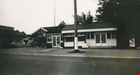
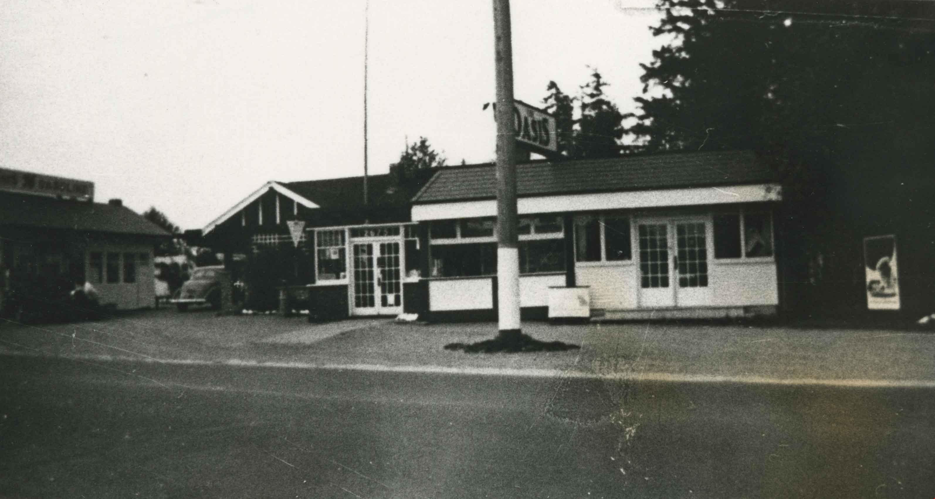
Oasis Restaurant
https://search.heritageburnaby.ca/link/archivedescription35629
- Repository
- City of Burnaby Archives
- Date
- 1926 (date of original), copied 1986
- Collection/Fonds
- Burnaby Historical Society fonds
- Description Level
- Item
- Physical Description
- 1 photograph : b&w ; 12.7 x 17.8 cm print
- Scope and Content
- Photograph of The Oasis restaurant, store, and night club (with dance floor), formerly The Oasis tea room. The Oasis was located at 2675 Kingsway (Pacific Highway). It was later renumbered 6105 Kingsway.
- Repository
- City of Burnaby Archives
- Date
- 1926 (date of original), copied 1986
- Collection/Fonds
- Burnaby Historical Society fonds
- Subseries
- Pioneer Tales subseries
- Physical Description
- 1 photograph : b&w ; 12.7 x 17.8 cm print
- Description Level
- Item
- Record No.
- 204-487
- Access Restriction
- No restrictions
- Reproduction Restriction
- No known restrictions
- Accession Number
- BHS1988-03
- Scope and Content
- Photograph of The Oasis restaurant, store, and night club (with dance floor), formerly The Oasis tea room. The Oasis was located at 2675 Kingsway (Pacific Highway). It was later renumbered 6105 Kingsway.
- Subjects
- Buildings - Commercial - Restaurants
- Names
- Oasis
- Media Type
- Photograph
- Notes
- Title based on contents of photograph
- Geographic Access
- Kingsway
- Street Address
- 6105 Kingsway
- Planning Study Area
- Windsor Area
Images
Burnaby South School yearbook : 1925-1926
https://search.heritageburnaby.ca/link/museumlibrary7508
- Repository
- Burnaby Village Museum
- Collection
- Special Collection
- Material Type
- Book
- Accession Code
- BV020.7.1
- Call Number
- 373.71 BUR 1926
- Place of Publication
- Burnaby, B.C.
- Publisher
- Burnaby South Secondary School
- Publication Date
- 1926
- Printer
- Lionel Ward & Co. Ltd.
- Inscription
- "Loretta S. Roberts"
- Library Subject (LOC)
- School yearbooks--1920-1929
- Schools--British Columbia--Burnaby
- School yearbooks
- Historic Neighbourhood
- Central Park (Historic Neighbourhood)
- Planning Study Area
- Windsor Area
- Geographic Access
- Rumble Street
- Street Address
- 5455 Rumble Street
- Object History
- This yearbook belonged to Lauretta Roberts.
- Notes
- High school annual for Burnaby South
![Sellers family, [1925] (date of original), copied 1986 thumbnail](/media/hpo/_Data/_Archives_Images/_Unrestricted/204/204-095.jpg?width=280)
Sellers family
https://search.heritageburnaby.ca/link/archivedescription35238
- Repository
- City of Burnaby Archives
- Date
- [1925] (date of original), copied 1986
- Collection/Fonds
- Burnaby Historical Society fonds
- Description Level
- Item
- Physical Description
- 1 photograph : b&w ; 12.7 x 17.8 cm print
- Scope and Content
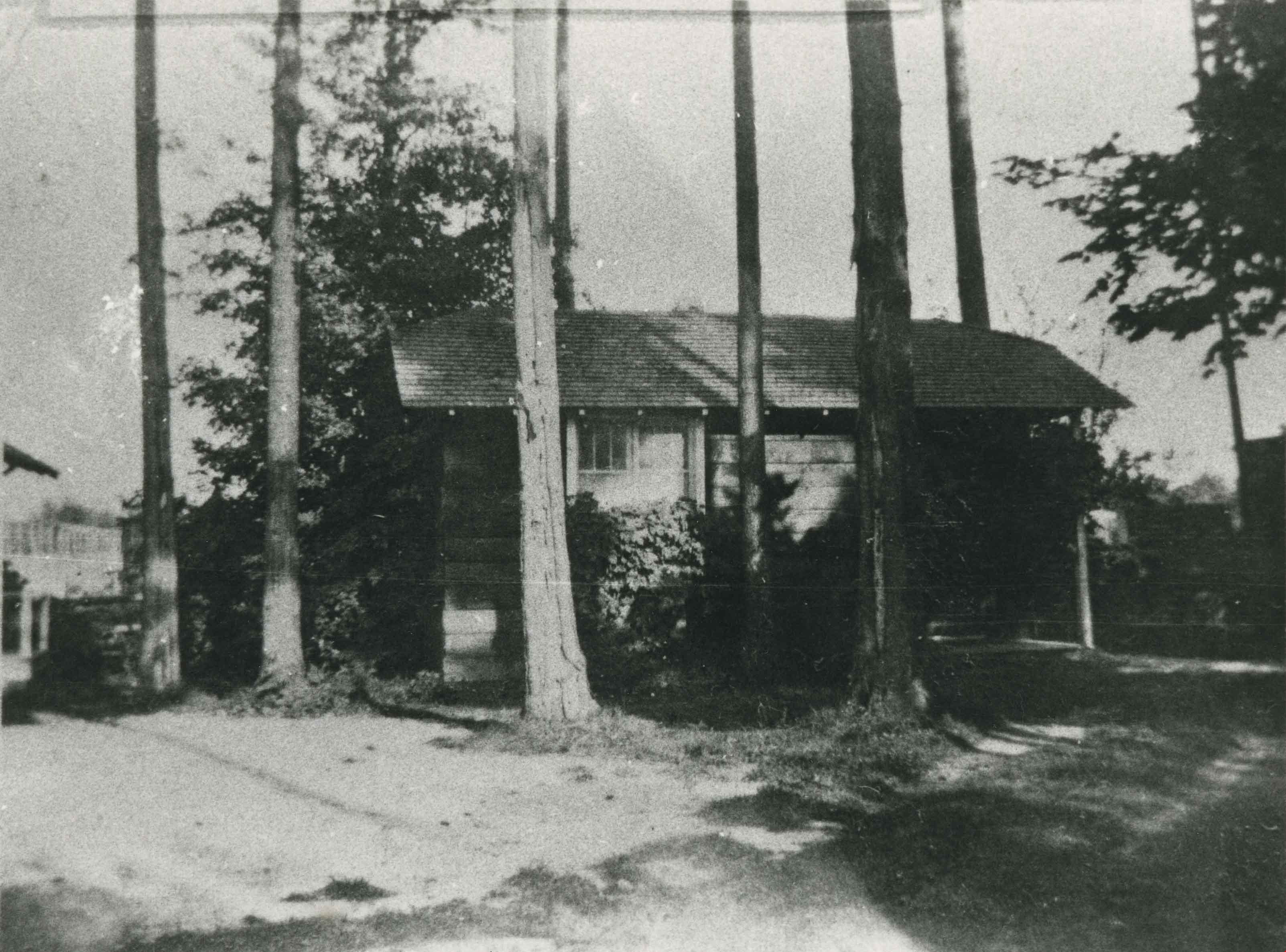
- Photograph of Harry Sellers (right), Hannah Sellers (front, 2nd from left), Herbert Sellers (left rear) and two daughters. The first half of the house Harry Sellers built by himself. From 1923 to 1928, the family lived in the front portion of the home while the remainder was being built. It was com…
- Repository
- City of Burnaby Archives
- Date
- [1925] (date of original), copied 1986
- Collection/Fonds
- Burnaby Historical Society fonds
- Subseries
- Pioneer Tales subseries
- Physical Description
- 1 photograph : b&w ; 12.7 x 17.8 cm print
- Description Level
- Item
- Record No.
- 204-095
- Access Restriction
- No restrictions
- Reproduction Restriction
- No known restrictions
- Accession Number
- BHS1988-03
- Scope and Content
- Photograph of Harry Sellers (right), Hannah Sellers (front, 2nd from left), Herbert Sellers (left rear) and two daughters. The first half of the house Harry Sellers built by himself. From 1923 to 1928, the family lived in the front portion of the home while the remainder was being built. It was completed in 1928.
- Media Type
- Photograph
- Notes
- Title based on contents of photograph
- Geographic Access
- Lane Street
- Street Address
- 3130 Princess Street
- 5680 Lane Street
- Historic Neighbourhood
- Central Park (Historic Neighbourhood)
- Planning Study Area
- Windsor Area
Images
![Sellers family, [1925] (date of original), copied 1986 thumbnail](/media/hpo/_Data/_Archives_Images/_Unrestricted/204/204-095.jpg)
![Windsor Street School Class, [1925] thumbnail](/media/hpo/_Data/_Archives_Images/_Unrestricted/204/204-149.jpg?width=280)
Windsor Street School Class
https://search.heritageburnaby.ca/link/archivedescription35292
- Repository
- City of Burnaby Archives
- Date
- [1925]
- Collection/Fonds
- Burnaby Historical Society fonds
- Description Level
- Item
- Physical Description
- photograph : b&w ; 12.7 x 17.8 cm print
- Scope and Content
- Photograph of Grades 3 and 4 at Windsor Street School. Margaret Urquhart (Peggy) is in the 3rd row, 4th from left. The teacher, to the right, is Miss Burke.
- Repository
- City of Burnaby Archives
- Date
- [1925]
- Collection/Fonds
- Burnaby Historical Society fonds
- Subseries
- Pioneer Tales subseries
- Physical Description
- photograph : b&w ; 12.7 x 17.8 cm print
- Description Level
- Item
- Record No.
- 204-149
- Access Restriction
- No restrictions
- Reproduction Restriction
- No known restrictions
- Accession Number
- BHS1988-03
- Scope and Content
- Photograph of Grades 3 and 4 at Windsor Street School. Margaret Urquhart (Peggy) is in the 3rd row, 4th from left. The teacher, to the right, is Miss Burke.
- Subjects
- Occupations - Teachers
- Media Type
- Photograph
- Notes
- Title based on contents of photograph
- Geographic Access
- Imperial Street
- Street Address
- 6166 Imperial Street
- Historic Neighbourhood
- Edmonds (Historic Neighbourhood)
- Planning Study Area
- Windsor Area
Images
![Windsor Street School Class, [1925] thumbnail](/media/hpo/_Data/_Archives_Images/_Unrestricted/204/204-149.jpg)