Narrow Results By

Masonic Cemetery
https://search.heritageburnaby.ca/link/landmark622
- Repository
- Burnaby Heritage Planning
- Description
- Cemetery site.
- Associated Dates
- 1924
- Street View URL
- Google Maps Street View
- Repository
- Burnaby Heritage Planning
- Geographic Access
- Halifax Street
- Associated Dates
- 1924
- Description
- Cemetery site.
- Heritage Value
- Tucked into a sloping site in a zone that is now transitional between light industrial and residential uses, the Masonic Cemetery is a beautifully landscaped oasis. Two outstanding features of this cemetery are the Woodward mausoleum, constructed in 1924, and the 1930s entrance gates. These substantial gates are constructed of random-coursed granite, and mark the cemetery’s main entrance off Douglas Road. An elaborate granite mausoleum, built for the prominent Woodward family, is located on axis with the main entry, at the brow of the slope. The Egyptian Revival style of the mausoleum was inspired by the opening of Tutankamun’s tomb just two years earlier, a discovery that sparked world-wide Egyptomania. The Woodward’s department store dynasty was founded by Charles Woodward (1852-1937), who visited Vancouver in 1891 and bought two lots for a store. Woodward’s drug department opened in 1895. In 1901, he took an option on a lot at the corner of Hastings and Abbott Streets and incorporated as Woodward’s Department Stores, which opened in November 1903. The family continued to run the business until 1993, when it went bankrupt and was sold to the Hudson’s Bay Company. A number of the Woodward family are interred here.
- Locality
- Vancouver Heights
- Historic Neighbourhood
- Vancouver Heights (Historic Neighbourhood)
- Planning Study Area
- Willingdon Heights Area
- Area
- 60137.87
- Contributing Resource
- Building
- Landscape Feature
- Ownership
- Private
- Street Address
- 4305 Halifax Street
- Street View URL
- Google Maps Street View
Images


4430 Halifax Street
https://search.heritageburnaby.ca/link/archivedescription93810
- Repository
- City of Burnaby Archives
- Date
- September 12, 1992
- Collection/Fonds
- Grover, Elliott & Co. Ltd. fonds
- Description Level
- Item
- Physical Description
- 1 photograph : col. ; 10 cm x 15 cm
- Scope and Content
- Photograph of a two-storey office building located at 4430 Halifax Street. Photograph is of the rear of the building and a small parking lot, taken from Buchanan Street.
- Repository
- City of Burnaby Archives
- Date
- September 12, 1992
- Collection/Fonds
- Grover, Elliott & Co. Ltd. fonds
- Physical Description
- 1 photograph : col. ; 10 cm x 15 cm
- Description Level
- Item
- Record No.
- 622-058
- Access Restriction
- No restrictions
- Reproduction Restriction
- No restrictions
- Accession Number
- 2017-39
- Scope and Content
- Photograph of a two-storey office building located at 4430 Halifax Street. Photograph is of the rear of the building and a small parking lot, taken from Buchanan Street.
- Subjects
- Buildings - Commercial - Offices
- Media Type
- Photograph
- Notes
- Transcribed title
- Title transcribed from envelope photographs were originally housed in
- File no. 92-337-B
- Photographer identified as "J.C."
- Geographic Access
- Halifax Street
- Street Address
- 4430 Halifax Street
- Historic Neighbourhood
- Vancouver Heights (Historic Neighbourhood)
- Planning Study Area
- Willingdon Heights Area
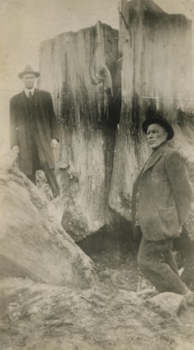
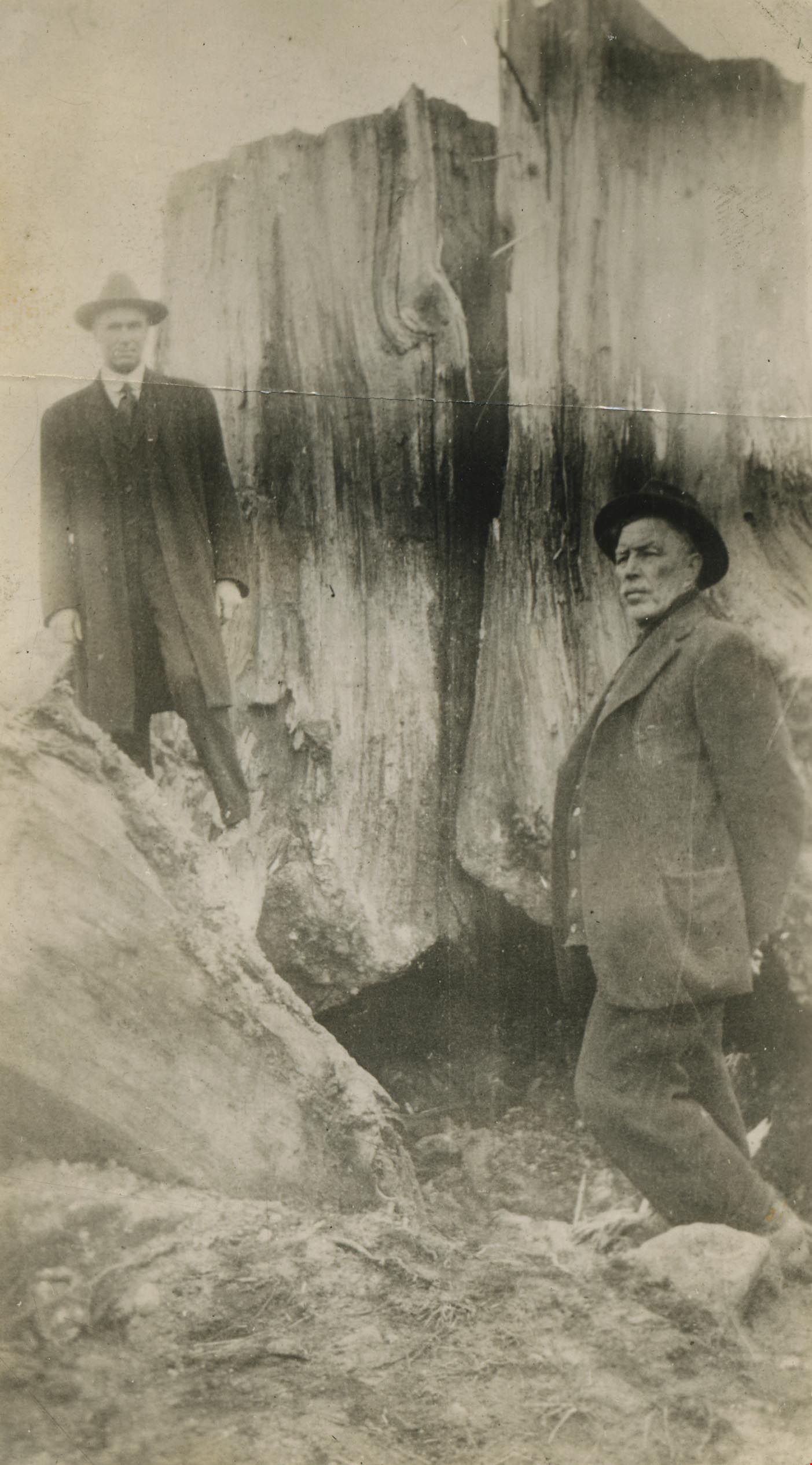
Mr. Tough and G.L. Lawson beside a tree stump
https://search.heritageburnaby.ca/link/archivedescription38544
- Repository
- City of Burnaby Archives
- Date
- 1921
- Collection/Fonds
- Burnaby Historical Society fonds
- Description Level
- Item
- Physical Description
- 1 photograph : b&w ; 6 x 10.8 cm
- Scope and Content
- Photograph of two men standing next to a large tree stump. A note written on the back of the photograph reads: " Stump blasted out by William Tough, street sup't [sic] in 1921. It stood on the boulevard on the south side of Hastings Street a few feet East of Ingleton. At left Councillor G. L. La…
- Repository
- City of Burnaby Archives
- Date
- 1921
- Collection/Fonds
- Burnaby Historical Society fonds
- Subseries
- New Westminster Public Library subseries
- Physical Description
- 1 photograph : b&w ; 6 x 10.8 cm
- Description Level
- Item
- Record No.
- 459-004
- Access Restriction
- No restrictions
- Reproduction Restriction
- No known restrictions
- Accession Number
- BHS2003-19
- Scope and Content
- Photograph of two men standing next to a large tree stump. A note written on the back of the photograph reads: " Stump blasted out by William Tough, street sup't [sic] in 1921. It stood on the boulevard on the south side of Hastings Street a few feet East of Ingleton. At left Councillor G. L. Lawson. Right, Mr. Tough." Councillor Lawson served on council from 1919-1920 and again from 1922-1923.
- Media Type
- Photograph
- Notes
- Title based on caption
- Geographic Access
- Hastings Street
- Ingleton Avenue
- Street Address
- 3900 Hastings Street
- Historic Neighbourhood
- Vancouver Heights (Historic Neighbourhood)
- Planning Study Area
- Willingdon Heights Area
Images

Vancouver Heights
https://search.heritageburnaby.ca/link/archivedescription35426
- Repository
- City of Burnaby Archives
- Date
- 1913 (date of original), copied 1986
- Collection/Fonds
- Burnaby Historical Society fonds
- Description Level
- Item
- Physical Description
- 1 photograph : b&w ; 12.7 x 17.8 cm print
- Scope and Content
- Photograph of a general view of Vancouver Heights. The car is on Ingleton Avenue near the corner of Triumph Street, looking east to MacDonald Avenue and Gilmore Avenue. Vancouver Heights Presbyterian Church and Gilmore Avenue School can be seen in the background at the right. The photograph is by D…
- Repository
- City of Burnaby Archives
- Date
- 1913 (date of original), copied 1986
- Collection/Fonds
- Burnaby Historical Society fonds
- Subseries
- Pioneer Tales subseries
- Physical Description
- 1 photograph : b&w ; 12.7 x 17.8 cm print
- Description Level
- Item
- Record No.
- 204-284
- Access Restriction
- No restrictions
- Reproduction Restriction
- No restrictions
- Accession Number
- BHS1988-03
- Scope and Content
- Photograph of a general view of Vancouver Heights. The car is on Ingleton Avenue near the corner of Triumph Street, looking east to MacDonald Avenue and Gilmore Avenue. Vancouver Heights Presbyterian Church and Gilmore Avenue School can be seen in the background at the right. The photograph is by Dr. Carl Eaton, teacher, principal and later family physician.
- Media Type
- Photograph
- Photographer
- Eaton, Dr. Carl
- Notes
- Title based on contents of photograph
- Geographic Access
- Ingleton Avenue
- MacDonald Avenue
- Triumph Street
- Historic Neighbourhood
- Vancouver Heights (Historic Neighbourhood)
- Planning Study Area
- Willingdon Heights Area
Images
