Narrow Results By
Subject
- Advertising Medium 3
- Advertising Medium - Business Cards 3
- Advertising Medium - Signs and Signboards 1
- Agriculture - Farms 1
- Buildings - Civic - Fire Halls 5
- Buildings - Commercial 8
- Buildings - Commercial - Bakeries
- Buildings - Commercial - Grocery Stores 1
- Buildings - Commercial - Restaurants 2
- Buildings - Commercial - Stores 1
- Buildings - Industrial - Mills 1
- Buildings - Religious - Churches
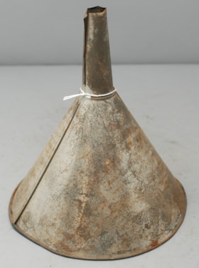
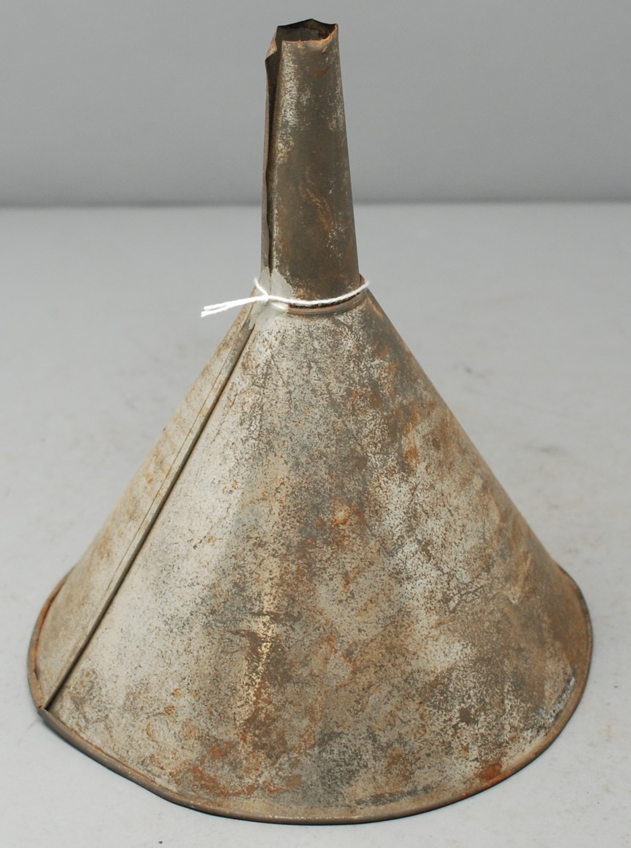
funnel
https://search.heritageburnaby.ca/link/museumartifact89581
- Repository
- Burnaby Village Museum
- Accession Code
- BV018.31.12
- Description
- funnel; metal funnel; conical bowl, with narrow neck.
- Object History
- Object was used by donor at Valley Bakery. Currently located at 4058 East Hastings Street, Valley Bakery opened in Burnaby in 1957 and is still owned and operated by the same family as of 2019.
- Category
- 04.Tools & Equipment for Materials
- Object Term
- Funnel
- Measurements
- L: 21.0 cm Dia.: 18.8 cm
- Names
- Valley Bakery
- Historic Neighbourhood
- Vancouver Heights (Historic Neighbourhood)
- Planning Study Area
- Burnaby Heights Area
Images
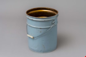
pail
https://search.heritageburnaby.ca/link/museumartifact89578
- Repository
- Burnaby Village Museum
- Accession Code
- BV018.31.9
- Description
- pail; large, steel "glucose" pail used at Valley Bakery; grey painted exterior, no lid, bail handle with opaque plastic grip; ca. 1950s; text stamped on bottom reads: "VULCAN / CTC-37C-80 / 28/26 79 / MADE IN CANADA / STC".
- Object History
- Object was used by donor at Valley Bakery, currently located at 4058 East Hastings Street, Valley Bakery opened in Burnaby in 1957 and is still owned and operated by the same family as of 2019.
- Category
- 04.Tools & Equipment for Materials
- Classification
- Food Processing & Preparation T&E - - Food Storage Equipment
- Object Term
- Container, Food Preparation
- Measurements
- H: 35.3 cm Dia.: 27.3 cm
- Historic Neighbourhood
- Vancouver Heights (Historic Neighbourhood)
- Planning Study Area
- Burnaby Heights Area
Images

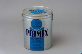
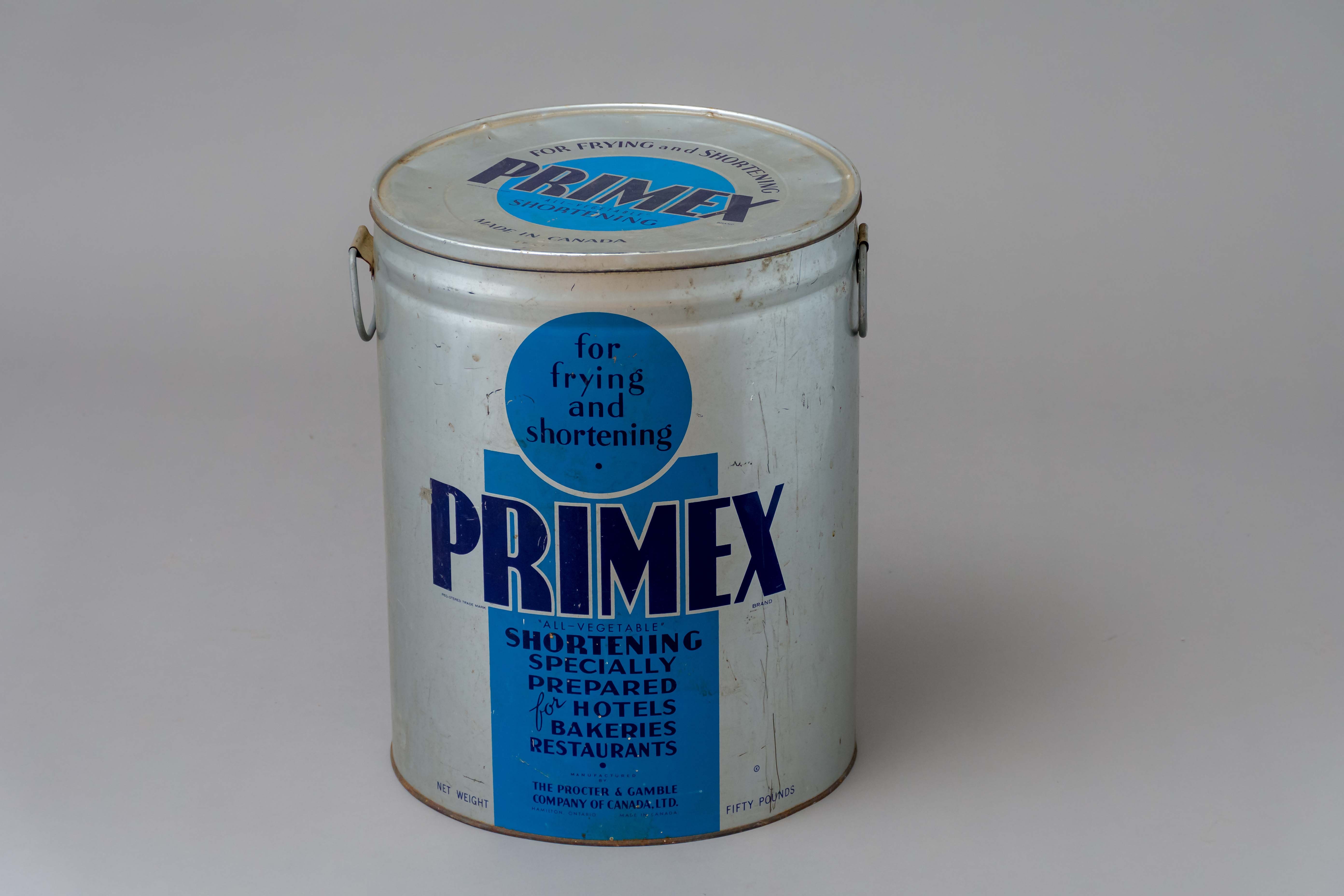
pail with lid
https://search.heritageburnaby.ca/link/museumartifact89579
- Repository
- Burnaby Village Museum
- Accession Code
- BV018.31.10
- Description
- pail; large, steel "shortening" pail used at Valley Bakery; silver painted exterior with blue graphics, circular steel lid, two loop handles on sides; ca. 1950s; text on sides reads: "for / frying / and / shortening / PRIMEX / "ALL-VEGETABLE" / SHORTENING / SPECIALLY / PREPARED / for HOTELS / BAKERIES / RESTAURANTS / MANUFACTURED / BY / THE PROCTER & GAMBLE / COMPANY OF CANADA LTD. / HAMILTON, ONTARIO MADE IN CANADA / NET WEIGHT FIFTY POUNDS".
- Object History
- Object was used by donor at Valley Bakery. Currently located at 4058 East Hastings Street, Valley Bakery opened in Burnaby in 1957 and is still owned and operated by the same family as of 2019.
- Category
- 04.Tools & Equipment for Materials
- Classification
- Food Processing & Preparation T&E - - Food Storage Equipment
- Object Term
- Container, Food Preparation
- Measurements
- L: 39.2 cm Dia.: 31.5 cm
- Names
- Valley Bakery
- Historic Neighbourhood
- Vancouver Heights (Historic Neighbourhood)
- Planning Study Area
- Burnaby Heights Area
Images
![St. Nicolas Parish Church, [ca.1912] thumbnail](/media/hpo/_Data/_BVM_Cartographic_Material/2003/2003_0083_0053_001.jpg?width=280)
St. Nicolas Parish Church
https://search.heritageburnaby.ca/link/museumdescription11931
- Repository
- Burnaby Village Museum
- Date
- [ca.1912]
- Collection/Fonds
- Ronald G. Scobbie collection
- Description Level
- Item
- Physical Description
- 1 plan : black ink and watercol. on paper ; 30.45 x 30.5 cm
- Scope and Content
- Item consists of a building insurance plan of St. Nicholas Anglican Church. Title on plan reads "St. Nicolas [sic] Parish Church / Lots 11 & 12 BK 10 DL 186 GP 1 / N.W.D.". Ingleton Avenue is identified to the east and Triumph Street to the south.
- Repository
- Burnaby Village Museum
- Collection/Fonds
- Ronald G. Scobbie collection
- Description Level
- Item
- Physical Description
- 1 plan : black ink and watercol. on paper ; 30.45 x 30.5 cm
- Material Details
- Scale 1 inch = 20 feet
- Scope and Content
- Item consists of a building insurance plan of St. Nicholas Anglican Church. Title on plan reads "St. Nicolas [sic] Parish Church / Lots 11 & 12 BK 10 DL 186 GP 1 / N.W.D.". Ingleton Avenue is identified to the east and Triumph Street to the south.
- Subjects
- Buildings - Religious - Churches
- Geographic Access
- Triumph Street
- Street Address
- 3883 Triumph Street
- Accession Code
- BV003.83.53
- Access Restriction
- No restrictions
- Reproduction Restriction
- No known restrictions
- Date
- [ca.1912]
- Media Type
- Cartographic Material
- Historic Neighbourhood
- Vancouver Heights (Historic Neighbourhood)
- Scan Resolution
- 600
- Scan Date
- 15-Jan-2021
- Scale
- 100
- Notes
- Transcribed title
- Note in pencil on verso reads: "St. Nicholas Parish Church / Lots 11 & 12 BK 10 DL 186 / 1" = 20' "
- Note in black ink on verso reads: "3704"
Images
![St. Nicolas Parish Church, [ca.1912] thumbnail](/media/hpo/_Data/_BVM_Cartographic_Material/2003/2003_0083_0053_001.jpg)