Narrow Results By
Subject
- Advertising Medium 3
- Advertising Medium - Business Cards 3
- Advertising Medium - Signs and Signboards 1
- Agriculture - Farms 1
- Buildings - Civic - Fire Halls 5
- Buildings - Commercial 8
- Buildings - Commercial - Bakeries 3
- Buildings - Commercial - Grocery Stores 1
- Buildings - Commercial - Restaurants 2
- Buildings - Commercial - Stores 1
- Buildings - Industrial - Mills 1
- Buildings - Religious - Churches 1
Creator
- Bingham, Alfred "Alf" 3
- Binks, James 1
- Blake, Frederick "Fred" 2
- British Columbia Underwriters' Association 6
- Burnaby Village Museum 2
- Burnett & McGugan, Engineers and Surveyors 2
- City of Burnaby 1
- Croton Studio Limited 6
- Heights Neighbourhood Association 1
- Henderson, Norman "Norm" 1
- Henton, John Morse 1
- Layton 1

Municipality of Burnaby - Volume XV and Volume XVIII
https://search.heritageburnaby.ca/link/museumdescription8680
- Repository
- Burnaby Village Museum
- Date
- May 1927
- Collection/Fonds
- Burnaby Village Museum Map collection
- Description Level
- File
- Physical Description
- 4 plans on 4 sheets : col. lithographic prints ; 63.5 x 53.5 cm folded to 53 x 31.5 cm
- Scope and Content
- File consists of four pages of plans removed from a bound book containing a series of fire insurance plans of the Municipality of Burnaby. The first two pages are numbered "A" and "B" and are key plans from "GREATER VANCOUVER B.C. / VOLUME XV / Surveyed _ May 1927 / MUNICIPALITY OF / BURNABY", "PLA…
- Repository
- Burnaby Village Museum
- Collection/Fonds
- Burnaby Village Museum Map collection
- Description Level
- File
- Physical Description
- 4 plans on 4 sheets : col. lithographic prints ; 63.5 x 53.5 cm folded to 53 x 31.5 cm
- Material Details
- Scales [1:1200] and [1:6000]
- Scope and Content
- File consists of four pages of plans removed from a bound book containing a series of fire insurance plans of the Municipality of Burnaby. The first two pages are numbered "A" and "B" and are key plans from "GREATER VANCOUVER B.C. / VOLUME XV / Surveyed _ May 1927 / MUNICIPALITY OF / BURNABY", "PLAN DEPT. FIRE BRANCH _ B.C. INSURANCE UNDERWRITERS ASSN.". Key Plan "B" covers plans: 1505; 1506; 1512 to 1516; 1540 to 1544; 1550 to 1557 and District Lots: 129 to 132; 135 to 138; 205 to 208 and 215 to 218. Key Plan "A" covers plans: 1501 to 1504; 1507 to 1511; 1517 to 1525; 1531 to 1539; 1545 to 1550 and District Lots: 116 to 127 and 186 to 189. Plan "1806" is part of "GREATER VANCOUVER B.C. / VOLUME XVIII / Municipality of Burnaby / May, 1927" and covers District Lot 153. Plan "1807" is from "GREATER VANCOUVER B.C. / VOLUME XVIII / Municipality of Burnaby / May, 1927" and covers District Lots: 99,149 and 152.
- Responsibility
- British Columbia Underwriters' Association
- Accession Code
- HV972.111.2
- Access Restriction
- No restrictions
- Reproduction Restriction
- May be restricted by third party rights
- Date
- May 1927
- Media Type
- Cartographic Material
- Historic Neighbourhood
- Vancouver Heights (Historic Neighbourhood)
- Lochdale (Historic Neighbourhood)
- Capitol Hill (Historic Neighbourhood)
- Central Park (Historic Neighbourhood)
- Alta Vista (Historic Neighbourhood)
- Planning Study Area
- Burnaby Heights Area
- Sperling-Broadway Area
- Lochdale Area
- Parkcrest-Aubrey Area
- Westridge Area
- Willingdon Heights Area
- Capitol Hill Area
- Maywood Area
- Marlborough Area
- Scan Resolution
- 400
- Scan Date
- 2021-11-18
- Notes
- Title based on content of plans
- Scales are measured 1 inch = 100 feet and 1 inch = 500 feet
- See also BV987.1.70d for revised versions of plans
Zoomable Images


Municipality of Burnaby - Volume XV and Volume XVIII
https://search.heritageburnaby.ca/link/museumdescription8681
- Repository
- Burnaby Village Museum
- Date
- May 1927
- Collection/Fonds
- Burnaby Village Museum Map collection
- Description Level
- File
- Physical Description
- 4 plans on 4 sheets : col. lithographic prints, ms. annotations in blue ink ; 63.5 x 53.5 cm folded to 53 x 31.5 cm
- Scope and Content
- File consists of four pages of plans removed from a bound book containing a series of fire insurance plans of the Municipality of Burnaby. Plan "1507" and plan "1517" are from "GREATER VANCOUVER B.C. / VOLUME XV / Municipality of Burnaby / May, 1927". Plan "1507" covers District Lot 186 and plan "1…
- Repository
- Burnaby Village Museum
- Collection/Fonds
- Burnaby Village Museum Map collection
- Description Level
- File
- Physical Description
- 4 plans on 4 sheets : col. lithographic prints, ms. annotations in blue ink ; 63.5 x 53.5 cm folded to 53 x 31.5 cm
- Material Details
- Scale [1:600] and [1:1200]
- Scope and Content
- File consists of four pages of plans removed from a bound book containing a series of fire insurance plans of the Municipality of Burnaby. Plan "1507" and plan "1517" are from "GREATER VANCOUVER B.C. / VOLUME XV / Municipality of Burnaby / May, 1927". Plan "1507" covers District Lot 186 and plan "1517" covers District Lot 116. Plan "1804" and plan "1805" are from "GREATER VANCOUVER B.C. / VOLUME XVIII / Municipality of Burnaby / May, 1927". Plans "1804" and "1805" cover District Lot 153.
- Responsibility
- British Columbia Underwriters' Association
- Accession Code
- HV972.111.3
- Access Restriction
- No restrictions
- Reproduction Restriction
- May be restricted by third party rights
- Date
- May 1927
- Media Type
- Cartographic Material
- Historic Neighbourhood
- Central Park (Historic Neighbourhood)
- Vancouver Heights (Historic Neighbourhood)
- Planning Study Area
- Maywood Area
- Willingdon Heights Area
- Scan Resolution
- 400
- Scan Date
- 2021-11-18
- Notes
- Title based on content of plans
- See also BV987.1.70d for revised versions of plans
- Scale is measured 1 inch = 100 feet
Images


![Municipality of Burnaby - Volume XV and Volume XVIII, 1927-[1940] thumbnail](/media/hpo/_Data/_BVM_Artifacts/1972/1972_0111_0004_003.jpg?width=280)
Municipality of Burnaby - Volume XV and Volume XVIII
https://search.heritageburnaby.ca/link/museumdescription8682
- Repository
- Burnaby Village Museum
- Date
- 1927-[1940]
- Collection/Fonds
- Burnaby Village Museum Map collection
- Description Level
- File
- Physical Description
- 4 plans on 4 sheets: col. lithographic prints ; 63.5 x 53.5 cm folded to 53 x 31.5 cm
- Scope and Content
- File consists of four pages of plans removed from a bound book containing a series of fire insurance plans of the Municipality of Burnaby. Plan "1518" and "1519" are from "GREATER VANCOUVER B.C. / VOLUME XV / Municipality of Burnaby / May, 1927". Plan "1518" covers District Lot 116 and Plan "1519"…
- Repository
- Burnaby Village Museum
- Collection/Fonds
- Burnaby Village Museum Map collection
- Description Level
- File
- Physical Description
- 4 plans on 4 sheets: col. lithographic prints ; 63.5 x 53.5 cm folded to 53 x 31.5 cm
- Material Details
- Scale [1:600]
- Scope and Content
- File consists of four pages of plans removed from a bound book containing a series of fire insurance plans of the Municipality of Burnaby. Plan "1518" and "1519" are from "GREATER VANCOUVER B.C. / VOLUME XV / Municipality of Burnaby / May, 1927". Plan "1518" covers District Lot 116 and Plan "1519" covers District Lot 121. Plan "1802" and plan "1803" are from "GREATER VANCOUVER B.C. / VOLUME XVIII / Municipality of Burnaby / May, 1927". Both plans "1802" and "1803" cover District Lot 153.
- Responsibility
- British Columbia Underwriters' Association
- Accession Code
- HV972.111.4
- Access Restriction
- No restrictions
- Reproduction Restriction
- May be restricted by third party rights
- Date
- 1927-[1940]
- Media Type
- Cartographic Material
- Historic Neighbourhood
- Vancouver Heights (Historic Neighbourhood)
- Central Park (Historic Neighbourhood)
- Planning Study Area
- Willingdon Heights Area
- Marlborough Area
- Scan Resolution
- 400
- Scan Date
- 2021-11-18
- Notes
- Title based on content of plans
- See also BV987.1.70d for revised versions of plans
- Scale is measured 1 inch = 50 feet
- Contact Burnaby Village Museum to access plans 1518 and 1519 (these plans have revisions on top - date of revisions is uncertain)
Images
![Municipality of Burnaby - Volume XV and Volume XVIII, 1927-[1940] thumbnail](/media/hpo/_Data/_BVM_Artifacts/1972/1972_0111_0004_003.jpg)


Municipality of Burnaby - Volume XV, Volume XVI, Volume XVII, Volume XVIII
https://search.heritageburnaby.ca/link/museumdescription8685
- Repository
- Burnaby Village Museum
- Date
- May 1927
- Collection/Fonds
- Burnaby Village Museum Map collection
- Description Level
- File
- Physical Description
- 4 plans on 4 sheets : col. lithographic prints ; 63.5 x 53.5 cm folded to 53 x 31.5 cm
- Scope and Content
- File consists of four pages of plans removed from a bound book containing a series of fire insurance plans of the Municipality of Burnaby. Plan "1531" is part of "GREATER VANCOUVER B.C. / VOLUME XV / Municipality of Burnaby / May 1927" and covers District Lots: 116 and 117. Key Plan "C" is part of …
- Repository
- Burnaby Village Museum
- Collection/Fonds
- Burnaby Village Museum Map collection
- Description Level
- File
- Physical Description
- 4 plans on 4 sheets : col. lithographic prints ; 63.5 x 53.5 cm folded to 53 x 31.5 cm
- Material Details
- Scale [1:600] and [1:1200]
- Scope and Content
- File consists of four pages of plans removed from a bound book containing a series of fire insurance plans of the Municipality of Burnaby. Plan "1531" is part of "GREATER VANCOUVER B.C. / VOLUME XV / Municipality of Burnaby / May 1927" and covers District Lots: 116 and 117. Key Plan "C" is part of "GREATER VANCOUVER B.C. / VOLUME XVI / Municipality of Burnaby / May 1927" and covers plans 1623 to 1651 and District Lots: 1 and 2; 4; 6; 8; 10 to 14; 25; 27; 40; 56 to 58; 88 and 89. Plan "1738" is part of "GREATER VANCOUVER B.C. / VOLUME XVII / Municipality of Burnaby / May 1927" and covers District Lots: 34 and 35. Key plan "G" is part of "GREATER VANCOUVER B.C. / VOLUME XVIII / Municipality of Burnaby / May 1927" and covers plans: 1801 to 1813; 1823; 1824; 1833 to 1838; 1841 to 1853 and District Lots: 32; 93; 94; 97 to 99; 149; 150; 152; 155 to 159; 161 to 164.
- Responsibility
- British Columbia Underwriters' Association
- Accession Code
- HV972.111.7
- Access Restriction
- No restrictions
- Reproduction Restriction
- May be restricted by third party rights
- Date
- May 1927
- Media Type
- Cartographic Material
- Historic Neighbourhood
- Central Park (Historic Neighbourhood)
- Fraser Arm (Historic Neighbourhood)
- Alta Vista (Historic Neighbourhood)
- Broadview (Historic Neighbourhood)
- Vancouver Heights (Historic Neighbourhood)
- Burquitlam (Historic Neighbourhood)
- East Burnaby (Historic Neighbourhood)
- Edmonds (Historic Neighbourhood)
- Lozells (Historic Neighbourhood)
- Planning Study Area
- Clinton-Glenwood Area
- Marlborough Area
- Maywood Area
- Windsor Area
- Big Bend Area
- Garden Village Area
- Willingdon Heights Area
- West Central Valley Area
- Cariboo-Armstrong Area
- Lyndhurst Area
- Cameron Area
- Lake City Area
- Edmonds Area
- Second Street Area
- Sperling-Broadway Area
- Lakeview-Mayfield Area
- Scan Resolution
- 400
- Scan Date
- 2021-11-18
- Notes
- Title based on content of plans
- See also BV987.1.70d for revised versions of plans
- Scale is measured 1 inch = 500 feet
Zoomable Images

Municipality of Burnaby - Volume XV, Volume XVI, Volume XVII, Volume XVIII, May 1927
Zoom into Image

Municipality of Burnaby- Volume XV and Volume XVIII
https://search.heritageburnaby.ca/link/museumdescription8686
- Repository
- Burnaby Village Museum
- Date
- May 1927
- Collection/Fonds
- Burnaby Village Museum Map collection
- Description Level
- File
- Physical Description
- 4 plans on 4 sheets : col. lithographic prints ; 63.5 x 53.5 cm folded to 53 x 31.5 cm
- Scope and Content
- File consists of four pages of plans removed from a bound book containing a series of fire insurance plans of the Municipality of Burnaby. Plan "1520" is part of "GREATER VANCOUVER B.C. / VOLUME XV / Municipality of Burnaby / May 1927" and covers District Lots: 121 and 187. Plann "1521" is part of …
- Repository
- Burnaby Village Museum
- Collection/Fonds
- Burnaby Village Museum Map collection
- Description Level
- File
- Physical Description
- 4 plans on 4 sheets : col. lithographic prints ; 63.5 x 53.5 cm folded to 53 x 31.5 cm
- Material Details
- Scale [1:600] and [1:1200]
- Scope and Content
- File consists of four pages of plans removed from a bound book containing a series of fire insurance plans of the Municipality of Burnaby. Plan "1520" is part of "GREATER VANCOUVER B.C. / VOLUME XV / Municipality of Burnaby / May 1927" and covers District Lots: 121 and 187. Plann "1521" is part of "GREATER VANCOUVER B.C. / VOLUME XV / Municipality of Burnaby / May 1927" and covers District Lots: 121 and 187. Key plan "H" reads: "GREATER VANCOUVER B.C. / VOLUME XVIII / Surveyed _ May 1927 / MUNICIPALITY OF / BURNABY" and covers plans: 1813 to 1822; 1824 to 1832; 1839; 1840; 1853 to 1865 and District Lots: 28; 30; 53; 90 to 93; 95 to 97; 155a; 155b; 155c; 159; 160; 171 to 173. Plan "1801" is part of "GREATER VANCOUVER B.C. / VOLUME XVIII / Municipality of Burnaby / May 1927" and covers District Lot 153.
- Responsibility
- British Columbia Underwriters' Association
- Accession Code
- HV972.111.8
- Access Restriction
- No restrictions
- Reproduction Restriction
- May be restricted by third party rights
- Date
- May 1927
- Media Type
- Cartographic Material
- Historic Neighbourhood
- Fraser Arm (Historic Neighbourhood)
- Vancouver Heights (Historic Neighbourhood)
- East Burnaby (Historic Neighbourhood)
- Edmonds (Historic Neighbourhood)
- Planning Study Area
- Marlborough Area
- Kingsway-Beresford Area
- Windsor Area
- Big Bend Area
- Clinton-Glenwood Area
- Burnaby Heights Area
- Edmonds Area
- Stride Avenue Area
- Scan Resolution
- 400
- Scan Date
- 2021-11-18
- Notes
- Title based on content of plans
- See also BV987.1.70d for revised versions of plans
- Scale is measured 1 inch = 500 feet
Zoomable Images

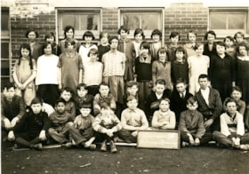
Gilmore Avenue School division VII class
https://search.heritageburnaby.ca/link/museumdescription13692
- Repository
- Burnaby Village Museum
- Date
- April 1927
- Collection/Fonds
- Westerman family fonds
- Description Level
- Item
- Physical Description
- 1 photograph : sepia ; 12.5 x 17.5 cm
- Scope and Content
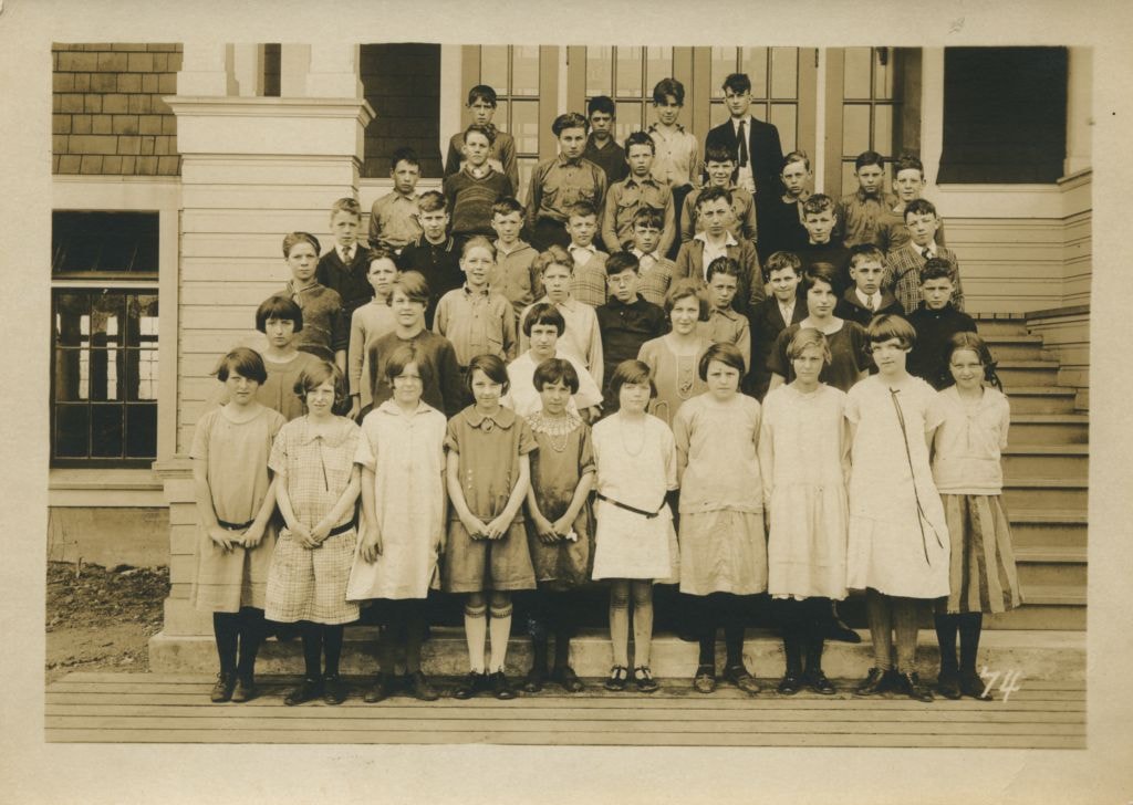
- Photograph of Gilmore Avenue School Division VII class arranged in rows outside of the school. Walter "Wally" Westerman is identified seated on the ground in the front row, fourth from left.
- Repository
- Burnaby Village Museum
- Collection/Fonds
- Westerman family fonds
- Description Level
- Item
- Physical Description
- 1 photograph : sepia ; 12.5 x 17.5 cm
- Material Details
- `
- Scope and Content
- Photograph of Gilmore Avenue School Division VII class arranged in rows outside of the school. Walter "Wally" Westerman is identified seated on the ground in the front row, fourth from left.
- Subjects
- Persons - Students
- Buildings - Schools
- Geographic Access
- Gilmore Avenue
- Street Address
- 50 Gilmore Avenue
- Accession Code
- BV020.17.16
- Access Restriction
- No restrictions
- Reproduction Restriction
- No known restrictions
- Date
- April 1927
- Media Type
- Photograph
- Historic Neighbourhood
- Vancouver Heights (Historic Neighbourhood)
- Planning Study Area
- Burnaby Heights Area
- Scan Resolution
- 600
- Scan Date
- 22-Sep-2020
- Scale
- 100
- Notes
- Title based on contents of photograph
- Handwritten note in pencil on verso of photograph reads: "Walter aged 10 years / April 1927"
Images
Fire insurance plans - Greater Vancouver - Volume XV - Municipality of Burnaby
https://search.heritageburnaby.ca/link/museumdescription17795
- Repository
- Burnaby Village Museum
- Date
- 1927-1940
- Collection/Fonds
- Burnaby Village Museum Map collection
- Description Level
- Item
- Physical Description
- 11 plans on 8 sheets : col. lithographic print ; 64 x 54 cm
- Scope and Content
- Item consists of fire insurance plans titled "Greater Vancouver / Volume XV / Municipality / of Burnaby" surveyed May 1927 and revised October 1940. Volume XV includes a two page Key Plan (A and B) identifying associated plan numbers and district lots and nine numbered fire insurance plans identifi…
- Repository
- Burnaby Village Museum
- Collection/Fonds
- Burnaby Village Museum Map collection
- Description Level
- Item
- Physical Description
- 11 plans on 8 sheets : col. lithographic print ; 64 x 54 cm
- Material Details
- Scales between [1:600] and [1:6000]
- Scope and Content
- Item consists of fire insurance plans titled "Greater Vancouver / Volume XV / Municipality / of Burnaby" surveyed May 1927 and revised October 1940. Volume XV includes a two page Key Plan (A and B) identifying associated plan numbers and district lots and nine numbered fire insurance plans identified as; 1507; 1508 ; 1517; 1518; 1519; 1520;1521; 1531and 1532.
- Publisher
- Plan Department of Fire Branch of British Columbia Underwriters' Association
- Accession Code
- BV987.1.70
- Access Restriction
- No restrictions
- Reproduction Restriction
- May be restricted by third party rights
- Date
- 1927-1940
- Media Type
- Cartographic Material
- Historic Neighbourhood
- Vancouver Heights (Historic Neighbourhood)
- Planning Study Area
- Burnaby Heights Area
- Willingdon Heights Area
- Scan Resolution
- 400
- Notes
- Title based on contents of item
- These plans are contained within a bound book with labels on cover page reading: "Plan No. 90 / THIS INSURANCE PLAN / of / Vancouver VOLUME "8" / IN THE PROPERTY OF THE / British Columbia Insurance Underwriter's Association / Vancouver B.C. / AND IS LOANED / MELVILLE F. THOMSON CO. .../ Date May 26th, 1934"; / "Plan No. 74 / THIS INSURANCE PLAN / OF / VANCOUVER VOLUME "9"" / Plan No. 11 / THIS INSURANCE PLAN / OF / BURNABY VOLUMES 15-19" / "THIS PLAN IS THE PROPERTY OF / THE / BRITISH LAW INSURANCE COMPANY / LIMITED"
- Fire insurance plans cover various district lots in Burnaby including: District Lot 116,121, 186 and 187.
- Sticker adhered to Key Plan B reads: "
- Contact Burnaby Village Museum to view fire insurance plans that are part of Volume XV

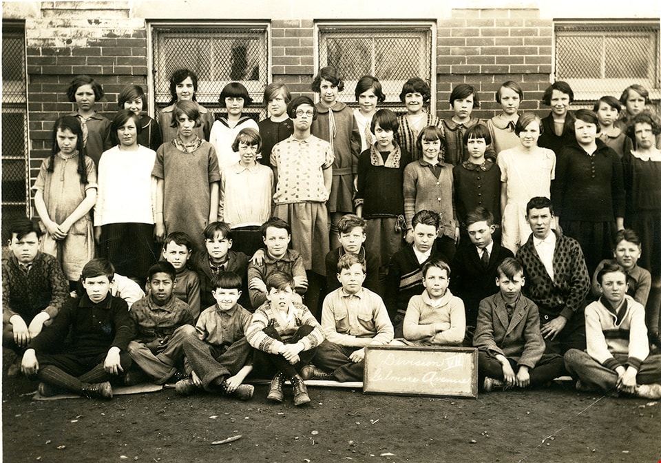
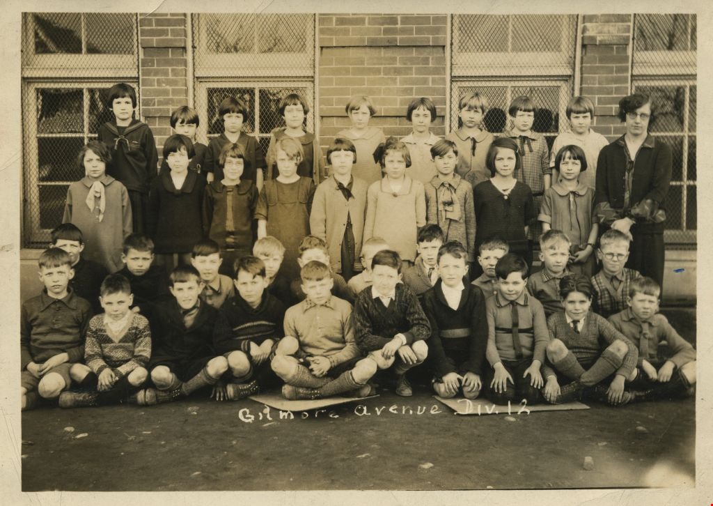
Gilmore Avenue Div. 12
https://search.heritageburnaby.ca/link/museumdescription1199
- Repository
- Burnaby Village Museum
- Date
- 1926
- Collection/Fonds
- Burnaby Village Museum Photograph collection
- Description Level
- Item
- Physical Description
- 1 photograph : b&w ; 16 x 11.5 cm
- Scope and Content
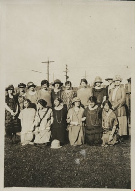
- Photograph of the Division 12 Grade 3 class at Gilmore Avenue School sitting and standing outside in rows with their teacher Miss Tough (far right). The twenty boys are sitting in two rows in the front and the eighteen girls and the teacher are standing in two rows in the back. The girls are mostly…
- Repository
- Burnaby Village Museum
- Collection/Fonds
- Burnaby Village Museum Photograph collection
- Description Level
- Item
- Physical Description
- 1 photograph : b&w ; 16 x 11.5 cm
- Material Details
- Title handwritten on negative by photographer has printed (white) on photograph
- Scope and Content
- Photograph of the Division 12 Grade 3 class at Gilmore Avenue School sitting and standing outside in rows with their teacher Miss Tough (far right). The twenty boys are sitting in two rows in the front and the eighteen girls and the teacher are standing in two rows in the back. The girls are mostly wearing dresses with round collars and the boys are mostly wearing sweaters over shirts, shorts and knee high socks with boots.
- Subjects
- Occupations - Teachers
- Geographic Access
- Gilmore Avenue
- Street Address
- 50 Gilmore Avenue
- Accession Code
- BV994.27.5
- Access Restriction
- No restrictions
- Date
- 1926
- Media Type
- Photograph
- Historic Neighbourhood
- Vancouver Heights (Historic Neighbourhood)
- Planning Study Area
- Burnaby Heights Area
- Scan Resolution
- 600
- Scan Date
- 01-Jun-09
- Scale
- 100
Images
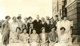
Gilmore Avenue School Staff
https://search.heritageburnaby.ca/link/museumdescription431
- Repository
- Burnaby Village Museum
- Date
- 1926
- Collection/Fonds
- Burnaby Village Museum Photograph collection
- Description Level
- Item
- Physical Description
- 1 photograph : b&w ; 7.0 x 11.5 cm mounted on paper 13.9 x 22.3 cm
- Scope and Content
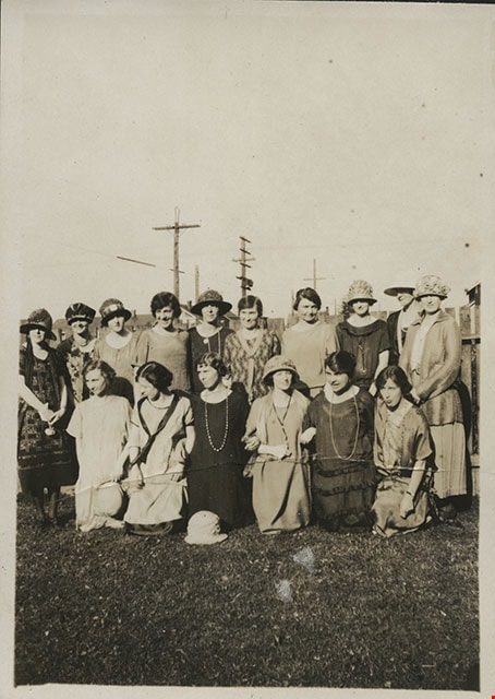
- Photograph of the staff at Gilmore Avenue School. They are lined up in rows by the side of the school. A letter from the donor, who was a teacher at Gilmore Avenue School from 1919 to 1926, identifies some of the people depicted in the photograph. Back row, standing (left to right): Ethel Whitwo…
- Repository
- Burnaby Village Museum
- Collection/Fonds
- Burnaby Village Museum Photograph collection
- Description Level
- Item
- Physical Description
- 1 photograph : b&w ; 7.0 x 11.5 cm mounted on paper 13.9 x 22.3 cm
- Scope and Content
- Photograph of the staff at Gilmore Avenue School. They are lined up in rows by the side of the school. A letter from the donor, who was a teacher at Gilmore Avenue School from 1919 to 1926, identifies some of the people depicted in the photograph. Back row, standing (left to right): Ethel Whitworth, unidentified woman, Dorothy Thompson, unidentified man standing behind Dorothy Thompson, unidentified woman, unidentified woman, Mr. Griffiths (principal), John Burnets, Mr. Pullinger, unidentified woman, Margaret Scott, Miss Keast, unidentified woman. Front row, sitting (left to right): unidentified woman, unidentified woman, unidentified woman, Dorothy Lupton (Mrs. E.W. Rogers), unidentified woman, Esther Wilks (Mrs. Dickson). An annotation on the album page reads: "Gilmore Ave. Sch. Staff. 1926."
- Subjects
- Occupations - Teachers
- Names
- Burnets, John
- Dickson, Esther Wilks
- Gilmore Avenue School
- Griffiths, Mr.
- Keast, Miss
- Pullinger, Mr.
- Rogers, Dorothy Lupton
- Scott, Margaret
- Thompson, Dorothy
- Whitworth, Ethel
- Geographic Access
- Gilmore Avenue
- Street Address
- 50 Gilmore Avenue
- Accession Code
- HV983.70.3
- Access Restriction
- No restrictions
- Reproduction Restriction
- No known restrictions
- Date
- 1926
- Media Type
- Photograph
- Historic Neighbourhood
- Vancouver Heights (Historic Neighbourhood)
- Planning Study Area
- Burnaby Heights Area
- Related Material
- The photograph shares the same paper mount as HV983.70.4, which is another photograph of the staff at Gilmore Avenue School.
- Scan Resolution
- 600
- Scan Date
- 2023-12-05
- Scale
- 100
- Notes
- Title based on caption of photograph
Images

Gilmore Avenue School staff
https://search.heritageburnaby.ca/link/museumdescription432
- Repository
- Burnaby Village Museum
- Date
- 1926
- Collection/Fonds
- Burnaby Village Museum Photograph collection
- Description Level
- Item
- Physical Description
- 1 photograph : sepia ; 8.3 x 5.9 cm mounted on paper 13.9 x 22.3 cm
- Scope and Content
- Photograph of the staff at Gilmore Avenue School. They are standing and kneeling together in two rows. A letter from the donor, who was a teacher at Gilmore Avenue School from 1919 to 1926, identifies some of the people depicted in the photograph. Kneeling in the front row, first from the left is…
- Repository
- Burnaby Village Museum
- Collection/Fonds
- Burnaby Village Museum Photograph collection
- Description Level
- Item
- Physical Description
- 1 photograph : sepia ; 8.3 x 5.9 cm mounted on paper 13.9 x 22.3 cm
- Scope and Content
- Photograph of the staff at Gilmore Avenue School. They are standing and kneeling together in two rows. A letter from the donor, who was a teacher at Gilmore Avenue School from 1919 to 1926, identifies some of the people depicted in the photograph. Kneeling in the front row, first from the left is Dorothy Lupton (Mrs. E.W. Rogers), and kneeling in the front row, wearing a dark dress with a string of beads, third from the left, is Esther Wilks (Mrs. Dickson). An annotation on the album page reads: "Gilmore Ave. Sch. Staff. 1926."
- Subjects
- Occupations - Teachers
- Geographic Access
- Gilmore Avenue
- Street Address
- 50 Gilmore Avenue
- Accession Code
- HV983.70.4
- Access Restriction
- No restrictions
- Reproduction Restriction
- No known restrictions
- Date
- 1926
- Media Type
- Photograph
- Historic Neighbourhood
- Vancouver Heights (Historic Neighbourhood)
- Planning Study Area
- Burnaby Heights Area
- Related Material
- The photograph shares the same paper mount as HV983.70.4, which is another photograph of the staff at Gilmore Avenue School.
- Scan Resolution
- 600
- Scan Date
- 2023-12-05
- Notes
- Title based on caption of photograph
Images
![Fire hall no. 1, [1925] (date of original) thumbnail](/media/hpo/_Data/_BVM_Images/1990/199800310005.jpg?width=280)
Fire hall no. 1
https://search.heritageburnaby.ca/link/museumdescription1296
- Repository
- Burnaby Village Museum
- Date
- [1925] (date of original)
- Collection/Fonds
- Burnaby Village Museum Photograph collection
- Description Level
- Item
- Physical Description
- 1 photograph : b&w ; 10 x 15 cm print
- Scope and Content
- Photograph of North Burnaby's first fire hall (the building was originally used as a pump house before it was converted).
- Repository
- Burnaby Village Museum
- Collection/Fonds
- Burnaby Village Museum Photograph collection
- Description Level
- Item
- Physical Description
- 1 photograph : b&w ; 10 x 15 cm print
- Scope and Content
- Photograph of North Burnaby's first fire hall (the building was originally used as a pump house before it was converted).
- Subjects
- Buildings - Civic - Fire Halls
- Names
- Burnaby Fire Department
- Geographic Access
- Carleton Avenue
- Eton Street
- Accession Code
- BV998.31.5
- Access Restriction
- No restrictions
- Reproduction Restriction
- No known restrictions
- Date
- [1925] (date of original)
- Media Type
- Photograph
- Historic Neighbourhood
- Vancouver Heights (Historic Neighbourhood)
- Planning Study Area
- Burnaby Heights Area
- Scan Resolution
- 600
- Scan Date
- 01-Jun-09
- Scale
- 100
- Photographer
- Blake, Frederick "Fred"
- Notes
- Title based on contents of photograph
- Typed sticker on verso of photograph reads: "Burnaby's first fire hall Carleton Ave. and Eton St. 290 N (1925)"
- Address sticker on verso of photograph reads: "MR & MRS F BLAKE 4165 PANDORA ST BURNABY BC V5C 2B2"
Images
![Fire hall no. 1, [1925] (date of original) thumbnail](/media/hpo/_Data/_BVM_Images/1990/199800310005.jpg)

First class at Kitchener Street School
https://search.heritageburnaby.ca/link/museumdescription102
- Repository
- Burnaby Village Museum
- Date
- 1925
- Collection/Fonds
- Burnaby Village Museum Photograph collection
- Description Level
- Item
- Physical Description
- 1 photograph : sepia ; 11 x 16 cm
- Scope and Content
- Photograph of the first class at Kitchener Street School. The students' ages vary, with few adults mixed in the group. They form six rows on the front steps of the school building. Dolly Knight is identified in the front row, first on left, her sister Margaret Norton (nee Knight) is in the front ro…
- Repository
- Burnaby Village Museum
- Collection/Fonds
- Burnaby Village Museum Photograph collection
- Description Level
- Item
- Physical Description
- 1 photograph : sepia ; 11 x 16 cm
- Scope and Content
- Photograph of the first class at Kitchener Street School. The students' ages vary, with few adults mixed in the group. They form six rows on the front steps of the school building. Dolly Knight is identified in the front row, first on left, her sister Margaret Norton (nee Knight) is in the front row, third from left and Margaret's twin brother Fred Knight is in the second row from the top.
- Geographic Access
- Gilmore Avenue
- Street Address
- 1351 Gilmore Avenue
- Accession Code
- BV988.31.4
- Access Restriction
- No restrictions
- Date
- 1925
- Media Type
- Photograph
- Historic Neighbourhood
- Vancouver Heights (Historic Neighbourhood)
- Planning Study Area
- Willingdon Heights Area
- Scan Resolution
- 600
- Scan Date
- 01-Jun-09
- Scale
- 100
- Notes
- Title based on contents of photograph
- Photographer identifies photograph as no. 74
- Note in blue pen on verso of photgraph reads: "First Class of new Kitchener St. School"
Images
![Tree stump at Willingdon Heights, [1924] thumbnail](/media/hpo/_Data/_BVM_Images/1976/1976_0046_0002_001.jpg?width=280)
Tree stump at Willingdon Heights
https://search.heritageburnaby.ca/link/museumdescription736
- Repository
- Burnaby Village Museum
- Date
- [1924]
- Collection/Fonds
- Burnaby Village Museum Photograph collection
- Description Level
- Item
- Physical Description
- 1 photograph : sepia ; 6.9 x 11.5 cm
- Scope and Content
- Photograph of a woman standing by a giant tree stump in Willingdon Heights. According to an accompanying note prepared by BVM and supported by the inscription on the photograph, the stump was at the southeast corner of Parker Street and Gilmore Avenue in the Willingdon Heights district. It is likel…
- Repository
- Burnaby Village Museum
- Collection/Fonds
- Burnaby Village Museum Photograph collection
- Description Level
- Item
- Physical Description
- 1 photograph : sepia ; 6.9 x 11.5 cm
- Material Details
- Annotations on the front of the photograph read: "Gilmour & Parker St South 1924" and "Willingdon Heights." An annotation on the back of the photograph reads, "25 feet at ground level / (A Bingham) March 11 1971." Stamped on the back of the photo: "457."
- Scope and Content
- Photograph of a woman standing by a giant tree stump in Willingdon Heights. According to an accompanying note prepared by BVM and supported by the inscription on the photograph, the stump was at the southeast corner of Parker Street and Gilmore Avenue in the Willingdon Heights district. It is likely that the woman in the picture is Ada Bingham, wife of Alfred Bingham who took the picture.
- Subjects
- Plants - Trees
- Names
- Bingham, Mary Ada "Ada"
- Geographic Access
- Parker Street
- Gilmore Avenue
- Accession Code
- HV976.46.2
- Access Restriction
- No restrictions
- Reproduction Restriction
- No known restrictions
- Date
- [1924]
- Media Type
- Photograph
- Historic Neighbourhood
- Vancouver Heights (Historic Neighbourhood)
- Planning Study Area
- Willingdon Heights Area
- Scan Resolution
- 600
- Scan Date
- 2023-06-20
- Photographer
- Bingham, Alfred "Alf"
- Notes
- Title based on contents of photograph
Images
![Tree stump at Willingdon Heights, [1924] thumbnail](/media/hpo/_Data/_BVM_Images/1976/1976_0046_0002_001.jpg)
![Toothpick stump at Gilmore Ave and Parker St, [1924] thumbnail](/media/hpo/_Data/_BVM_Images/1976/1976_0046_0003_001.jpg?width=280)
Toothpick stump at Gilmore Ave and Parker St
https://search.heritageburnaby.ca/link/museumdescription737
- Repository
- Burnaby Village Museum
- Date
- [1924]
- Collection/Fonds
- Burnaby Village Museum Photograph collection
- Description Level
- Item
- Physical Description
- 1 photograph : b&w ; 11.5 x 6.9 cm
- Scope and Content
- Photograph of a man sitting near the top of a giant tree stump at Willingdon Heights. According to an accompanying note prepared by Burnaby Village Museum and supported by the inscription on the photograph, the stump was at the southeast corner of Parker Street and Gilmore Avenue in the Willingdon…
- Repository
- Burnaby Village Museum
- Collection/Fonds
- Burnaby Village Museum Photograph collection
- Description Level
- Item
- Physical Description
- 1 photograph : b&w ; 11.5 x 6.9 cm
- Material Details
- Annotations on the front of the photograph read: "Gilmour & Parker. South. 1924" and "Toothpick Stump." An annotation on the back of the photograph reads, "Wide - 98 inch at TOB [sic - top] / Ground level 25 feet / SE corner of Parker & Gilmour / March 11 1971 / A Bingham."
- Scope and Content
- Photograph of a man sitting near the top of a giant tree stump at Willingdon Heights. According to an accompanying note prepared by Burnaby Village Museum and supported by the inscription on the photograph, the stump was at the southeast corner of Parker Street and Gilmore Avenue in the Willingdon Heights district.
- Subjects
- Plants - Trees
- Names
- Bingham, Alfred "Alf"
- Geographic Access
- Parker Street
- Gilmore Avenue
- Accession Code
- HV976.46.3
- Access Restriction
- No restrictions
- Reproduction Restriction
- No known restrictions
- Date
- [1924]
- Media Type
- Photograph
- Historic Neighbourhood
- Vancouver Heights (Historic Neighbourhood)
- Planning Study Area
- Willingdon Heights Area
- Scan Resolution
- 600
- Scan Date
- 2023-06-20
- Photographer
- Bingham, Alfred "Alf"
- Notes
- Title based on caption of photograph
Images
![Toothpick stump at Gilmore Ave and Parker St, [1924] thumbnail](/media/hpo/_Data/_BVM_Images/1976/1976_0046_0003_001.jpg)
![Gilmore Avenue School students, [between 1920 and 1925] thumbnail](/media/hpo/_Data/_BVM_Images/1990/199400270009.jpg?width=280)
Gilmore Avenue School students
https://search.heritageburnaby.ca/link/museumdescription1200
- Repository
- Burnaby Village Museum
- Date
- [between 1920 and 1925]
- Collection/Fonds
- Burnaby Village Museum Photograph collection
- Description Level
- Item
- Physical Description
- 1 photograph : sepia ; 11 x 15.5 cm
- Scope and Content
- Photograph of a class on the front steps of Gilmore Avenue School. The group consists of twenty-one boys and nineteen girls, aged about eight or nine. Most of the girls have short hair and are wearing dresses or skirts just above the knees with knee high socks. The boys are in either shirts or swea…
- Repository
- Burnaby Village Museum
- Collection/Fonds
- Burnaby Village Museum Photograph collection
- Description Level
- Item
- Physical Description
- 1 photograph : sepia ; 11 x 15.5 cm
- Scope and Content
- Photograph of a class on the front steps of Gilmore Avenue School. The group consists of twenty-one boys and nineteen girls, aged about eight or nine. Most of the girls have short hair and are wearing dresses or skirts just above the knees with knee high socks. The boys are in either shirts or sweaters.
- Names
- Gilmore Avenue School
- Geographic Access
- Gilmore Avenue
- Street Address
- 50 Gilmore Avenue
- Accession Code
- BV994.27.9
- Access Restriction
- No restrictions
- Date
- [between 1920 and 1925]
- Media Type
- Photograph
- Historic Neighbourhood
- Vancouver Heights (Historic Neighbourhood)
- Planning Study Area
- Burnaby Heights Area
- Scan Resolution
- 600
- Scan Date
- 01-Jun-09
- Scale
- 100
- Notes
- Title based on contents of photograph
- Photographer identifies photograph as no. "921"
Images
![Gilmore Avenue School students, [between 1920 and 1925] thumbnail](/media/hpo/_Data/_BVM_Images/1990/199400270009.jpg)
![Gilmore Avenue School, [192-] thumbnail](/media/hpo/_Data/_BVM_Images/1985/1985_0100_0004_001.jpg?width=280)
Gilmore Avenue School
https://search.heritageburnaby.ca/link/museumdescription2992
- Repository
- Burnaby Village Museum
- Date
- [192-]
- Collection/Fonds
- Burnaby Village Museum Photograph collection
- Description Level
- Item
- Physical Description
- 1 photograph : b&w postcard ; 8.9 x 13.9 cm
- Scope and Content
- Photograph of the front of the Gilmore Avenue School. Note the doors and stairways added on to the side of the building, and the electric power pole and the power lines in front of the school building. Inscribed in the original negative and printed on the bottom front right of the photograph: "Gil…
- Repository
- Burnaby Village Museum
- Collection/Fonds
- Burnaby Village Museum Photograph collection
- Description Level
- Item
- Physical Description
- 1 photograph : b&w postcard ; 8.9 x 13.9 cm
- Scope and Content
- Photograph of the front of the Gilmore Avenue School. Note the doors and stairways added on to the side of the building, and the electric power pole and the power lines in front of the school building. Inscribed in the original negative and printed on the bottom front right of the photograph: "Gilmore Ave. School / Van. Heights. / Vancouver, B.C." Printed on the bottom front left of the postcard: "J.M. Henton. Photographer, Vancouver, B.C."
- Subjects
- Buildings - Schools
- Geographic Access
- Gilmore Avenue
- Street Address
- 50 Gilmore Avenue
- Accession Code
- BV985.100.4
- Access Restriction
- No restrictions
- Reproduction Restriction
- No known restrictions
- Date
- [192-]
- Media Type
- Photograph
- Historic Neighbourhood
- Vancouver Heights (Historic Neighbourhood)
- Planning Study Area
- Burnaby Heights Area
- Related Material
- For another postcard of the same image, see HV983.70.2 stored with the postcards.
- Scan Resolution
- 600
- Scan Date
- 2024-02-02
- Photographer
- Henton, John Morse
- Notes
- Title based on contents of photograph
Images
![Gilmore Avenue School, [192-] thumbnail](/media/hpo/_Data/_BVM_Images/1985/1985_0100_0004_001.jpg)
![Front view of 4108 Trinity Street, [192-] thumbnail](/media/hpo/_Data/_BVM_Images/2007/2007_0045_0002_001.jpg?width=280)
Front view of 4108 Trinity Street
https://search.heritageburnaby.ca/link/museumdescription3886
- Repository
- Burnaby Village Museum
- Date
- [192-]
- Collection/Fonds
- Burnaby Village Museum Photograph collection
- Description Level
- Item
- Physical Description
- 1 photograph : b&w ; 10.5 x 6.5 cm
- Scope and Content
- Photograph of house at 4108 Trinity St. Front view looking north, no other homes visible. Porches are not quite finished.
- Repository
- Burnaby Village Museum
- Collection/Fonds
- Burnaby Village Museum Photograph collection
- Description Level
- Item
- Physical Description
- 1 photograph : b&w ; 10.5 x 6.5 cm
- Material Details
- "4108 Trinity St / Front view / looking north" written on back in black ink.
- Scope and Content
- Photograph of house at 4108 Trinity St. Front view looking north, no other homes visible. Porches are not quite finished.
- History
- George Vincent Martin was born in 1892 in England. He married Matilda Florence Reed in 1916. He purchased a property in North Burnaby in the 1920s on Trinity Street. There was a main house and a "shack" on the property split up onto two lots.
- Geographic Access
- Trinity Street
- Street Address
- 4108 Trinity Street
- Accession Code
- BV007.45.2
- Access Restriction
- No restrictions
- Reproduction Restriction
- No known restrictions
- Date
- [192-]
- Media Type
- Photograph
- Historic Neighbourhood
- Vancouver Heights (Historic Neighbourhood)
- Planning Study Area
- Burnaby Heights Area
- Scan Resolution
- 300
- Scan Date
- 29-Nov-2018
- Scale
- 96
- Notes
- Title based on notation on the reverse of the photograph
Images
![Front view of 4108 Trinity Street, [192-] thumbnail](/media/hpo/_Data/_BVM_Images/2007/2007_0045_0002_001.jpg)
![Granny Ellis with grandson, Bob Roberts, [between 1920 and 1925] thumbnail](/media/hpo/_Data/_BVM_Images/2020/2020_0034_0010_001.jpg?width=280)
Granny Ellis with grandson, Bob Roberts
https://search.heritageburnaby.ca/link/museumdescription15321
- Repository
- Burnaby Village Museum
- Date
- [between 1920 and 1925]
- Collection/Fonds
- Margaret Norton fonds
- Description Level
- Item
- Physical Description
- 1 photograph : b&w ; 17.5 x 12.5 cm
- Scope and Content
- Photograph of Louisa Ellis sitting on the stoop of her house with her grandson, Charles "Bob" Roberts and family dog. The house is located at 931 Gilmore Avenue in Burnaby.
- Repository
- Burnaby Village Museum
- Collection/Fonds
- Margaret Norton fonds
- Description Level
- Item
- Physical Description
- 1 photograph : b&w ; 17.5 x 12.5 cm
- Scope and Content
- Photograph of Louisa Ellis sitting on the stoop of her house with her grandson, Charles "Bob" Roberts and family dog. The house is located at 931 Gilmore Avenue in Burnaby.
- Geographic Access
- Gilmore Avenue
- Street Address
- 931 Gilmore Avenue
- Accession Code
- BV020.34.10
- Access Restriction
- No restrictions
- Reproduction Restriction
- No known restrictions
- Date
- [between 1920 and 1925]
- Media Type
- Photograph
- Historic Neighbourhood
- Vancouver Heights (Historic Neighbourhood)
- Planning Study Area
- Willingdon Heights Area
- Scan Resolution
- 600
- Scan Date
- March 22, 2021
- Scale
- 100
- Notes
- Title based on contents of photograph
Images
![Granny Ellis with grandson, Bob Roberts, [between 1920 and 1925] thumbnail](/media/hpo/_Data/_BVM_Images/2020/2020_0034_0010_001.jpg)

Div 1 Gilmore Avenue School
https://search.heritageburnaby.ca/link/museumdescription22
- Repository
- Burnaby Village Museum
- Date
- 17 Mar. 1920
- Collection/Fonds
- Burnaby Village Museum Photograph collection
- Description Level
- Item
- Physical Description
- 1 photograph : sepia ; 11.1 x 16.2 cm
- Scope and Content
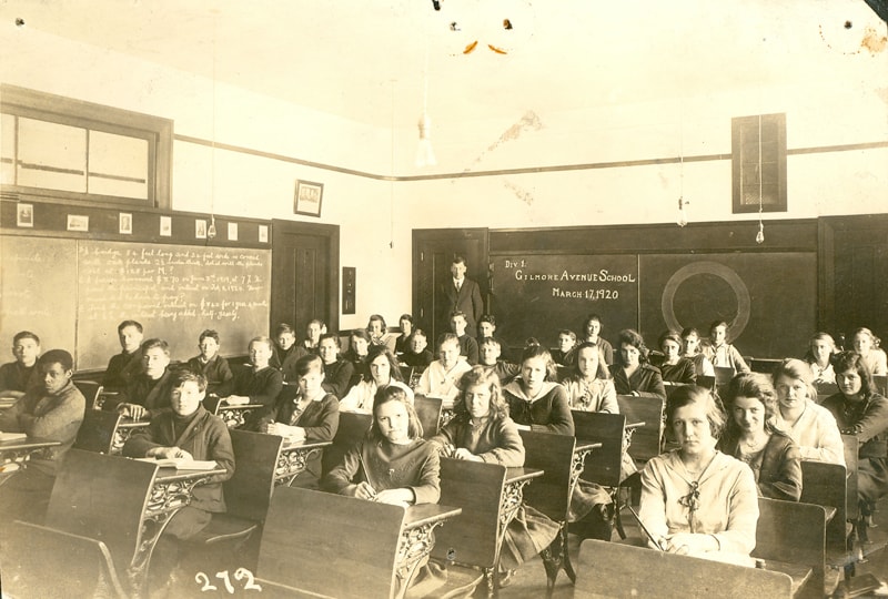
- Photograph of the Division One class at Gilmore Avenue School (this information is written on a blackboard at the rear of the classroom). A male teacher is standing beside the blackboard and the class is seated at their desks (each desk is attached to the back of the chair in the front). There are …
- Repository
- Burnaby Village Museum
- Collection/Fonds
- Burnaby Village Museum Photograph collection
- Description Level
- Item
- Physical Description
- 1 photograph : sepia ; 11.1 x 16.2 cm
- Scope and Content
- Photograph of the Division One class at Gilmore Avenue School (this information is written on a blackboard at the rear of the classroom). A male teacher is standing beside the blackboard and the class is seated at their desks (each desk is attached to the back of the chair in the front). There are 21 girls and 14 boys. The boys are dressed in sweaters or rough sports jackets, baggy trousers, and open-necked shirts. Their hair is generally moppish, or parted. The girls are generally wearing sweaters and wide skirts, with several wearing necklaces. Most have long hair, pulled back and tied, or parted and hanging. Identified: (3rd row of desks, 5th from left) Mary Warren; (1st row of desks, 4th from left) Lena Horne (later Lena McManus). Mary Warren was the daughter of John H. Warren and Mary W. Warren (nee Slaven) who settled in Burnaby and built a house on Union Street in 1912. Mary Warren later became Mary Anthony when she married Bill Anthony. The teacher may be Stanley Griffiths. A blackboard on the left of the picture has math problems written on it. Above, a row of prints hang, among the ones identifiable are Shakespeare and the Fathers of Confederation. The room is lit by dangling electric bulbs. Inscribed on the negative, lower left of the print: "272." An annotation in pencil on the back of the photograph reads, "Mr. Tom Browning." In 1912 Gilmore Ave. School was only a tent as blasting and clearing was being carried out. Later that year, a four-room building was completed and pupils moved in. By 1914, another four rooms were added to meet increased enrolment. Four rooms were added again in 1922, and four rooms and an auditorium were added in 1929. The school was renovated in 1954 and 1955. A library was added in 1964 and six more rooms were built in 1967. The school was named after Hugh B. Gilmour, but an error by a municipal clerk in 1912 changed the spelling to Gilmore.
- Names
- Gilmore Avenue School
- Geographic Access
- Gilmore Avenue
- Street Address
- 50 Gilmore Avenue
- Accession Code
- HV971.23.3
- Access Restriction
- No restrictions
- Reproduction Restriction
- No known restrictions
- Date
- 17 Mar. 1920
- Media Type
- Photograph
- Historic Neighbourhood
- Vancouver Heights (Historic Neighbourhood)
- Planning Study Area
- Willingdon Heights Area
- Scan Resolution
- 600
- Scan Date
- 2023-03-21
- Notes
- Title based on contents of photograph
Images
![Gilmore Avenue School classroom, [1920] thumbnail](/media/hpo/_Data/_BVM_Images/1985/198800310001.jpg?width=280)
Gilmore Avenue School classroom
https://search.heritageburnaby.ca/link/museumdescription99
- Repository
- Burnaby Village Museum
- Date
- [1920]
- Collection/Fonds
- Burnaby Village Museum Photograph collection
- Description Level
- Item
- Physical Description
- 1 photograph : sepia ; 11 x 16.5 cm
- Scope and Content
- Photograph of students in a classroom at Gilmore Avenue School seated on their chair with their hands behind their backs. Their teacher is standing at the back of the classroom in front of a black board. Most girls are wearing bows in their hair and almost all of the students are wearing sweaters (…
- Repository
- Burnaby Village Museum
- Collection/Fonds
- Burnaby Village Museum Photograph collection
- Description Level
- Item
- Physical Description
- 1 photograph : sepia ; 11 x 16.5 cm
- Scope and Content
- Photograph of students in a classroom at Gilmore Avenue School seated on their chair with their hands behind their backs. Their teacher is standing at the back of the classroom in front of a black board. Most girls are wearing bows in their hair and almost all of the students are wearing sweaters (bare light bulbs and empty light sockets are hanging from the ceiling).
- Subjects
- Occupations - Teachers
- Names
- Gilmore Avenue School
- Geographic Access
- Gilmore Avenue
- Street Address
- 50 Gilmore Avenue
- Accession Code
- BV988.31.1
- Access Restriction
- No restrictions
- Date
- [1920]
- Media Type
- Photograph
- Historic Neighbourhood
- Vancouver Heights (Historic Neighbourhood)
- Planning Study Area
- Willingdon Heights Area
- Scan Resolution
- 600
- Scan Date
- 01-Jun-09
- Scale
- 100
- Notes
- Title based on contents of photograph
- Photographer identifies photograph as no. 264
- Note in blue pen on verso of photgraph reads: "Gilmore st. School/ year?"
Images
![Gilmore Avenue School classroom, [1920] thumbnail](/media/hpo/_Data/_BVM_Images/1985/198800310001.jpg)