Narrow Results By
Subject
- Advertising Medium 3
- Advertising Medium - Business Cards 3
- Advertising Medium - Signs and Signboards 1
- Agriculture - Farms 1
- Buildings - Civic - Fire Halls 5
- Buildings - Commercial 8
- Buildings - Commercial - Bakeries 3
- Buildings - Commercial - Grocery Stores 1
- Buildings - Commercial - Restaurants 2
- Buildings - Commercial - Stores 1
- Buildings - Industrial - Mills 1
- Buildings - Religious - Churches 1
Creator
- Bingham, Alfred "Alf" 3
- Binks, James 1
- Blake, Frederick "Fred" 2
- British Columbia Underwriters' Association 6
- Burnaby Village Museum 2
- Burnett & McGugan, Engineers and Surveyors 2
- City of Burnaby 1
- Croton Studio Limited 6
- Heights Neighbourhood Association 1
- Henderson, Norman "Norm" 1
- Henton, John Morse 1
- Layton 1
![Members of the Knight family under tree, [194-] thumbnail](/media/hpo/_Data/_BVM_Images/2020/2020_0034_0023_001.jpg?width=280)
Members of the Knight family under tree
https://search.heritageburnaby.ca/link/museumdescription15334
- Repository
- Burnaby Village Museum
- Date
- [194-]
- Collection/Fonds
- Margaret Norton fonds
- Description Level
- Item
- Physical Description
- 1 photograph : sepia ; 9 x 6.5 cm
- Scope and Content
- Photograph of members of the Knight family (left to right) Naida Hansen (nee Knight), Dolly Walker-Kirkwood (nee Knight), Fred Knight and Lila McKinley (nee Knight) and Margaret Norton (nee Knight) (cut off). The group have their arms around each other and are standing under a willow tree in the ya…
- Repository
- Burnaby Village Museum
- Collection/Fonds
- Margaret Norton fonds
- Description Level
- Item
- Physical Description
- 1 photograph : sepia ; 9 x 6.5 cm
- Scope and Content
- Photograph of members of the Knight family (left to right) Naida Hansen (nee Knight), Dolly Walker-Kirkwood (nee Knight), Fred Knight and Lila McKinley (nee Knight) and Margaret Norton (nee Knight) (cut off). The group have their arms around each other and are standing under a willow tree in the yard of the family home at 931 Gilmore Avenue.
- Names
- Norton, Margaret Knight
- Hansen, Naida Knight
- Knight, Frederick "Fred"
- Walker-Kirkwood, Dolly Knight
- McKinley, Lila Knight
- Geographic Access
- Gilmore Avenue
- Street Address
- 931 Gilmore Avenue
- Accession Code
- BV020.34.23
- Access Restriction
- No restrictions
- Reproduction Restriction
- No known restrictions
- Date
- [194-]
- Media Type
- Photograph
- Historic Neighbourhood
- Vancouver Heights (Historic Neighbourhood)
- Planning Study Area
- Willingdon Heights Area
- Scan Resolution
- 600
- Scan Date
- March 22, 2021
- Scale
- 100
- Notes
- Title based on contents of photograph
Images
![Members of the Knight family under tree, [194-] thumbnail](/media/hpo/_Data/_BVM_Images/2020/2020_0034_0023_001.jpg)
![Miss Muir's class, [1912] thumbnail](/media/hpo/_Data/_BVM_Images/1985/1985_0100_0003_001.jpg?width=280)
Miss Muir's class
https://search.heritageburnaby.ca/link/museumdescription2991
- Repository
- Burnaby Village Museum
- Date
- [1912]
- Collection/Fonds
- Burnaby Village Museum Photograph collection
- Description Level
- Item
- Physical Description
- 1 photograph : b&w postcard ; 8.9 x 14.0 cm
- Scope and Content
- Photographic postcard of students about age seven sitting and standing in three rows in front of the doors of a school. There are sixteen girls and eleven boys. Their female teacher stands by them to the right side of the photograph. Annotations on the back of the postcard read: "Miss Muir?" and "G…
- Repository
- Burnaby Village Museum
- Collection/Fonds
- Burnaby Village Museum Photograph collection
- Description Level
- Item
- Physical Description
- 1 photograph : b&w postcard ; 8.9 x 14.0 cm
- Scope and Content
- Photographic postcard of students about age seven sitting and standing in three rows in front of the doors of a school. There are sixteen girls and eleven boys. Their female teacher stands by them to the right side of the photograph. Annotations on the back of the postcard read: "Miss Muir?" and "Gilmore School / 1912?"
- Geographic Access
- Gilmore Avenue
- Street Address
- 50 Gilmore Avenue
- Accession Code
- BV985.100.3
- Access Restriction
- No restrictions
- Reproduction Restriction
- May be restricted by third party rights
- Date
- [1912]
- Media Type
- Photograph
- Historic Neighbourhood
- Vancouver Heights (Historic Neighbourhood)
- Planning Study Area
- Burnaby Heights Area
- Scan Resolution
- 600
- Scan Date
- 2024-01-09
- Notes
- Title based on contents of photograph
Images
![Miss Muir's class, [1912] thumbnail](/media/hpo/_Data/_BVM_Images/1985/1985_0100_0003_001.jpg)
![Miss Scott's class at Vancouver Heights Public School, [after 1912] thumbnail](/media/hpo/_Data/_BVM_Images/1985/198900190001.jpg?width=280)
Miss Scott's class at Vancouver Heights Public School
https://search.heritageburnaby.ca/link/museumdescription72
- Repository
- Burnaby Village Museum
- Date
- [after 1912]
- Collection/Fonds
- Burnaby Village Museum Photograph collection
- Description Level
- Item
- Physical Description
- 1 photograph : sepia ; 10 x 15 cm mounted on card 18 x 23 cm
- Scope and Content
- Photograph of Miss Scott's class taken on the steps of Vancouver Heights Public School. The students are standing in seven rows and Miss Scott is standing on the left at the end of the second row.
- Repository
- Burnaby Village Museum
- Collection/Fonds
- Burnaby Village Museum Photograph collection
- Description Level
- Item
- Physical Description
- 1 photograph : sepia ; 10 x 15 cm mounted on card 18 x 23 cm
- Scope and Content
- Photograph of Miss Scott's class taken on the steps of Vancouver Heights Public School. The students are standing in seven rows and Miss Scott is standing on the left at the end of the second row.
- Subjects
- Occupations - Teachers
- Geographic Access
- Gilmore Avenue
- Street Address
- 50 Gilmore Avenue
- Accession Code
- BV989.19.1
- Access Restriction
- No restrictions
- Date
- [after 1912]
- Media Type
- Photograph
- Historic Neighbourhood
- Vancouver Heights (Historic Neighbourhood)
- Planning Study Area
- Burnaby Heights Area
- Scan Resolution
- 600
- Scan Date
- 01-Jun-09
- Scale
- 100
- Photographer
- McConnell, W. F.
- Notes
- Title based on contents of photograph
- Note written in pencil on verso of card mount reads: "R. G. McManus/ 4257 Dundas St [top two lines crossed out]/ North Burnaby B.C" and "c/o Terry Lynn Callender/ TEACHER MISS SCOTT"
- Note written in pen on verso of card mount reads: "AS OF FEB 28/85/ DAVID L. McMANUS/ [address follows]"
- Embossed letters on the card mount reads: "W. F. McConnell/ VANCOUVER, B.C."
Images
![Miss Scott's class at Vancouver Heights Public School, [after 1912] thumbnail](/media/hpo/_Data/_BVM_Images/1985/198900190001.jpg)

Municipality of Burnaby - Volume XV and Volume XVIII
https://search.heritageburnaby.ca/link/museumdescription8680
- Repository
- Burnaby Village Museum
- Date
- May 1927
- Collection/Fonds
- Burnaby Village Museum Map collection
- Description Level
- File
- Physical Description
- 4 plans on 4 sheets : col. lithographic prints ; 63.5 x 53.5 cm folded to 53 x 31.5 cm
- Scope and Content
- File consists of four pages of plans removed from a bound book containing a series of fire insurance plans of the Municipality of Burnaby. The first two pages are numbered "A" and "B" and are key plans from "GREATER VANCOUVER B.C. / VOLUME XV / Surveyed _ May 1927 / MUNICIPALITY OF / BURNABY", "PLA…
- Repository
- Burnaby Village Museum
- Collection/Fonds
- Burnaby Village Museum Map collection
- Description Level
- File
- Physical Description
- 4 plans on 4 sheets : col. lithographic prints ; 63.5 x 53.5 cm folded to 53 x 31.5 cm
- Material Details
- Scales [1:1200] and [1:6000]
- Scope and Content
- File consists of four pages of plans removed from a bound book containing a series of fire insurance plans of the Municipality of Burnaby. The first two pages are numbered "A" and "B" and are key plans from "GREATER VANCOUVER B.C. / VOLUME XV / Surveyed _ May 1927 / MUNICIPALITY OF / BURNABY", "PLAN DEPT. FIRE BRANCH _ B.C. INSURANCE UNDERWRITERS ASSN.". Key Plan "B" covers plans: 1505; 1506; 1512 to 1516; 1540 to 1544; 1550 to 1557 and District Lots: 129 to 132; 135 to 138; 205 to 208 and 215 to 218. Key Plan "A" covers plans: 1501 to 1504; 1507 to 1511; 1517 to 1525; 1531 to 1539; 1545 to 1550 and District Lots: 116 to 127 and 186 to 189. Plan "1806" is part of "GREATER VANCOUVER B.C. / VOLUME XVIII / Municipality of Burnaby / May, 1927" and covers District Lot 153. Plan "1807" is from "GREATER VANCOUVER B.C. / VOLUME XVIII / Municipality of Burnaby / May, 1927" and covers District Lots: 99,149 and 152.
- Responsibility
- British Columbia Underwriters' Association
- Accession Code
- HV972.111.2
- Access Restriction
- No restrictions
- Reproduction Restriction
- May be restricted by third party rights
- Date
- May 1927
- Media Type
- Cartographic Material
- Historic Neighbourhood
- Vancouver Heights (Historic Neighbourhood)
- Lochdale (Historic Neighbourhood)
- Capitol Hill (Historic Neighbourhood)
- Central Park (Historic Neighbourhood)
- Alta Vista (Historic Neighbourhood)
- Planning Study Area
- Burnaby Heights Area
- Sperling-Broadway Area
- Lochdale Area
- Parkcrest-Aubrey Area
- Westridge Area
- Willingdon Heights Area
- Capitol Hill Area
- Maywood Area
- Marlborough Area
- Scan Resolution
- 400
- Scan Date
- 2021-11-18
- Notes
- Title based on content of plans
- Scales are measured 1 inch = 100 feet and 1 inch = 500 feet
- See also BV987.1.70d for revised versions of plans
Zoomable Images


Municipality of Burnaby - Volume XV and Volume XVIII
https://search.heritageburnaby.ca/link/museumdescription8681
- Repository
- Burnaby Village Museum
- Date
- May 1927
- Collection/Fonds
- Burnaby Village Museum Map collection
- Description Level
- File
- Physical Description
- 4 plans on 4 sheets : col. lithographic prints, ms. annotations in blue ink ; 63.5 x 53.5 cm folded to 53 x 31.5 cm
- Scope and Content
- File consists of four pages of plans removed from a bound book containing a series of fire insurance plans of the Municipality of Burnaby. Plan "1507" and plan "1517" are from "GREATER VANCOUVER B.C. / VOLUME XV / Municipality of Burnaby / May, 1927". Plan "1507" covers District Lot 186 and plan "1…
- Repository
- Burnaby Village Museum
- Collection/Fonds
- Burnaby Village Museum Map collection
- Description Level
- File
- Physical Description
- 4 plans on 4 sheets : col. lithographic prints, ms. annotations in blue ink ; 63.5 x 53.5 cm folded to 53 x 31.5 cm
- Material Details
- Scale [1:600] and [1:1200]
- Scope and Content
- File consists of four pages of plans removed from a bound book containing a series of fire insurance plans of the Municipality of Burnaby. Plan "1507" and plan "1517" are from "GREATER VANCOUVER B.C. / VOLUME XV / Municipality of Burnaby / May, 1927". Plan "1507" covers District Lot 186 and plan "1517" covers District Lot 116. Plan "1804" and plan "1805" are from "GREATER VANCOUVER B.C. / VOLUME XVIII / Municipality of Burnaby / May, 1927". Plans "1804" and "1805" cover District Lot 153.
- Responsibility
- British Columbia Underwriters' Association
- Accession Code
- HV972.111.3
- Access Restriction
- No restrictions
- Reproduction Restriction
- May be restricted by third party rights
- Date
- May 1927
- Media Type
- Cartographic Material
- Historic Neighbourhood
- Central Park (Historic Neighbourhood)
- Vancouver Heights (Historic Neighbourhood)
- Planning Study Area
- Maywood Area
- Willingdon Heights Area
- Scan Resolution
- 400
- Scan Date
- 2021-11-18
- Notes
- Title based on content of plans
- See also BV987.1.70d for revised versions of plans
- Scale is measured 1 inch = 100 feet
Images


![Municipality of Burnaby - Volume XV and Volume XVIII, 1927-[1940] thumbnail](/media/hpo/_Data/_BVM_Artifacts/1972/1972_0111_0004_003.jpg?width=280)
Municipality of Burnaby - Volume XV and Volume XVIII
https://search.heritageburnaby.ca/link/museumdescription8682
- Repository
- Burnaby Village Museum
- Date
- 1927-[1940]
- Collection/Fonds
- Burnaby Village Museum Map collection
- Description Level
- File
- Physical Description
- 4 plans on 4 sheets: col. lithographic prints ; 63.5 x 53.5 cm folded to 53 x 31.5 cm
- Scope and Content
- File consists of four pages of plans removed from a bound book containing a series of fire insurance plans of the Municipality of Burnaby. Plan "1518" and "1519" are from "GREATER VANCOUVER B.C. / VOLUME XV / Municipality of Burnaby / May, 1927". Plan "1518" covers District Lot 116 and Plan "1519"…
- Repository
- Burnaby Village Museum
- Collection/Fonds
- Burnaby Village Museum Map collection
- Description Level
- File
- Physical Description
- 4 plans on 4 sheets: col. lithographic prints ; 63.5 x 53.5 cm folded to 53 x 31.5 cm
- Material Details
- Scale [1:600]
- Scope and Content
- File consists of four pages of plans removed from a bound book containing a series of fire insurance plans of the Municipality of Burnaby. Plan "1518" and "1519" are from "GREATER VANCOUVER B.C. / VOLUME XV / Municipality of Burnaby / May, 1927". Plan "1518" covers District Lot 116 and Plan "1519" covers District Lot 121. Plan "1802" and plan "1803" are from "GREATER VANCOUVER B.C. / VOLUME XVIII / Municipality of Burnaby / May, 1927". Both plans "1802" and "1803" cover District Lot 153.
- Responsibility
- British Columbia Underwriters' Association
- Accession Code
- HV972.111.4
- Access Restriction
- No restrictions
- Reproduction Restriction
- May be restricted by third party rights
- Date
- 1927-[1940]
- Media Type
- Cartographic Material
- Historic Neighbourhood
- Vancouver Heights (Historic Neighbourhood)
- Central Park (Historic Neighbourhood)
- Planning Study Area
- Willingdon Heights Area
- Marlborough Area
- Scan Resolution
- 400
- Scan Date
- 2021-11-18
- Notes
- Title based on content of plans
- See also BV987.1.70d for revised versions of plans
- Scale is measured 1 inch = 50 feet
- Contact Burnaby Village Museum to access plans 1518 and 1519 (these plans have revisions on top - date of revisions is uncertain)
Images
![Municipality of Burnaby - Volume XV and Volume XVIII, 1927-[1940] thumbnail](/media/hpo/_Data/_BVM_Artifacts/1972/1972_0111_0004_003.jpg)


Municipality of Burnaby- Volume XV and Volume XVIII
https://search.heritageburnaby.ca/link/museumdescription8686
- Repository
- Burnaby Village Museum
- Date
- May 1927
- Collection/Fonds
- Burnaby Village Museum Map collection
- Description Level
- File
- Physical Description
- 4 plans on 4 sheets : col. lithographic prints ; 63.5 x 53.5 cm folded to 53 x 31.5 cm
- Scope and Content
- File consists of four pages of plans removed from a bound book containing a series of fire insurance plans of the Municipality of Burnaby. Plan "1520" is part of "GREATER VANCOUVER B.C. / VOLUME XV / Municipality of Burnaby / May 1927" and covers District Lots: 121 and 187. Plann "1521" is part of …
- Repository
- Burnaby Village Museum
- Collection/Fonds
- Burnaby Village Museum Map collection
- Description Level
- File
- Physical Description
- 4 plans on 4 sheets : col. lithographic prints ; 63.5 x 53.5 cm folded to 53 x 31.5 cm
- Material Details
- Scale [1:600] and [1:1200]
- Scope and Content
- File consists of four pages of plans removed from a bound book containing a series of fire insurance plans of the Municipality of Burnaby. Plan "1520" is part of "GREATER VANCOUVER B.C. / VOLUME XV / Municipality of Burnaby / May 1927" and covers District Lots: 121 and 187. Plann "1521" is part of "GREATER VANCOUVER B.C. / VOLUME XV / Municipality of Burnaby / May 1927" and covers District Lots: 121 and 187. Key plan "H" reads: "GREATER VANCOUVER B.C. / VOLUME XVIII / Surveyed _ May 1927 / MUNICIPALITY OF / BURNABY" and covers plans: 1813 to 1822; 1824 to 1832; 1839; 1840; 1853 to 1865 and District Lots: 28; 30; 53; 90 to 93; 95 to 97; 155a; 155b; 155c; 159; 160; 171 to 173. Plan "1801" is part of "GREATER VANCOUVER B.C. / VOLUME XVIII / Municipality of Burnaby / May 1927" and covers District Lot 153.
- Responsibility
- British Columbia Underwriters' Association
- Accession Code
- HV972.111.8
- Access Restriction
- No restrictions
- Reproduction Restriction
- May be restricted by third party rights
- Date
- May 1927
- Media Type
- Cartographic Material
- Historic Neighbourhood
- Fraser Arm (Historic Neighbourhood)
- Vancouver Heights (Historic Neighbourhood)
- East Burnaby (Historic Neighbourhood)
- Edmonds (Historic Neighbourhood)
- Planning Study Area
- Marlborough Area
- Kingsway-Beresford Area
- Windsor Area
- Big Bend Area
- Clinton-Glenwood Area
- Burnaby Heights Area
- Edmonds Area
- Stride Avenue Area
- Scan Resolution
- 400
- Scan Date
- 2021-11-18
- Notes
- Title based on content of plans
- See also BV987.1.70d for revised versions of plans
- Scale is measured 1 inch = 500 feet
Zoomable Images


Municipality of Burnaby - Volume XV, Volume XVI, Volume XVII, Volume XVIII
https://search.heritageburnaby.ca/link/museumdescription8685
- Repository
- Burnaby Village Museum
- Date
- May 1927
- Collection/Fonds
- Burnaby Village Museum Map collection
- Description Level
- File
- Physical Description
- 4 plans on 4 sheets : col. lithographic prints ; 63.5 x 53.5 cm folded to 53 x 31.5 cm
- Scope and Content
- File consists of four pages of plans removed from a bound book containing a series of fire insurance plans of the Municipality of Burnaby. Plan "1531" is part of "GREATER VANCOUVER B.C. / VOLUME XV / Municipality of Burnaby / May 1927" and covers District Lots: 116 and 117. Key Plan "C" is part of …
- Repository
- Burnaby Village Museum
- Collection/Fonds
- Burnaby Village Museum Map collection
- Description Level
- File
- Physical Description
- 4 plans on 4 sheets : col. lithographic prints ; 63.5 x 53.5 cm folded to 53 x 31.5 cm
- Material Details
- Scale [1:600] and [1:1200]
- Scope and Content
- File consists of four pages of plans removed from a bound book containing a series of fire insurance plans of the Municipality of Burnaby. Plan "1531" is part of "GREATER VANCOUVER B.C. / VOLUME XV / Municipality of Burnaby / May 1927" and covers District Lots: 116 and 117. Key Plan "C" is part of "GREATER VANCOUVER B.C. / VOLUME XVI / Municipality of Burnaby / May 1927" and covers plans 1623 to 1651 and District Lots: 1 and 2; 4; 6; 8; 10 to 14; 25; 27; 40; 56 to 58; 88 and 89. Plan "1738" is part of "GREATER VANCOUVER B.C. / VOLUME XVII / Municipality of Burnaby / May 1927" and covers District Lots: 34 and 35. Key plan "G" is part of "GREATER VANCOUVER B.C. / VOLUME XVIII / Municipality of Burnaby / May 1927" and covers plans: 1801 to 1813; 1823; 1824; 1833 to 1838; 1841 to 1853 and District Lots: 32; 93; 94; 97 to 99; 149; 150; 152; 155 to 159; 161 to 164.
- Responsibility
- British Columbia Underwriters' Association
- Accession Code
- HV972.111.7
- Access Restriction
- No restrictions
- Reproduction Restriction
- May be restricted by third party rights
- Date
- May 1927
- Media Type
- Cartographic Material
- Historic Neighbourhood
- Central Park (Historic Neighbourhood)
- Fraser Arm (Historic Neighbourhood)
- Alta Vista (Historic Neighbourhood)
- Broadview (Historic Neighbourhood)
- Vancouver Heights (Historic Neighbourhood)
- Burquitlam (Historic Neighbourhood)
- East Burnaby (Historic Neighbourhood)
- Edmonds (Historic Neighbourhood)
- Lozells (Historic Neighbourhood)
- Planning Study Area
- Clinton-Glenwood Area
- Marlborough Area
- Maywood Area
- Windsor Area
- Big Bend Area
- Garden Village Area
- Willingdon Heights Area
- West Central Valley Area
- Cariboo-Armstrong Area
- Lyndhurst Area
- Cameron Area
- Lake City Area
- Edmonds Area
- Second Street Area
- Sperling-Broadway Area
- Lakeview-Mayfield Area
- Scan Resolution
- 400
- Scan Date
- 2021-11-18
- Notes
- Title based on content of plans
- See also BV987.1.70d for revised versions of plans
- Scale is measured 1 inch = 500 feet
Zoomable Images

Municipality of Burnaby - Volume XV, Volume XVI, Volume XVII, Volume XVIII, May 1927
Zoom into Image
My life on The Heights : Burnaby B.C. 1932 -1938, 1946 - 1977
https://search.heritageburnaby.ca/link/museumlibrary6744
- Repository
- Burnaby Village Museum
- Collection
- Special Collection
- Material Type
- Book
- Accession Code
- BV016.45.1
- Call Number
- 921 PEN
- Author
- Penn, Edna
- Place of Publication
- [Burnaby]
- Publisher
- Self Published
- Publication Date
- 2016
- Physical Description
- 55 p. : ill.(some col.) ; 28 cm.
- Library Subject (LOC)
- Burnaby (B.C.)--History--Anecdotes
- Burnaby (B.C.)--Social Life and Customs
- Burnaby (B.C.)
- British Columbia--Social life and customs
- British Columbia--History
- Biography
- Historic Neighbourhood
- Vancouver Heights (Historic Neighbourhood)
- Names
- Gilmore Avenue School
- Object History
- This is the second family history book that Edna has published.
- Notes
- Edna Penn is the mother of Douglas Penn who wrote the history of the Burnaby Fire Department "Follow That Fire"
![Naida Knight, [193-] thumbnail](/media/hpo/_Data/_BVM_Images/2020/2020_0034_0022_001.jpg?width=280)
Naida Knight
https://search.heritageburnaby.ca/link/museumdescription15333
- Repository
- Burnaby Village Museum
- Date
- [193-]
- Collection/Fonds
- Margaret Norton fonds
- Description Level
- Item
- Physical Description
- 1 photograph : sepia hand-tinted col. ; 14.7 x 9 cm
- Scope and Content
- Photograph of Naida Hansen (nee Knight) standing in the garden of the Knight-Roberts family home at 931 Gilmore Avenue, Burnaby.
- Repository
- Burnaby Village Museum
- Collection/Fonds
- Margaret Norton fonds
- Description Level
- Item
- Physical Description
- 1 photograph : sepia hand-tinted col. ; 14.7 x 9 cm
- Scope and Content
- Photograph of Naida Hansen (nee Knight) standing in the garden of the Knight-Roberts family home at 931 Gilmore Avenue, Burnaby.
- Geographic Access
- Gilmore Avenue
- Street Address
- 931 Gilmore Avenue
- Accession Code
- BV020.34.22
- Access Restriction
- No restrictions
- Reproduction Restriction
- No known restrictions
- Date
- [193-]
- Media Type
- Photograph
- Historic Neighbourhood
- Vancouver Heights (Historic Neighbourhood)
- Planning Study Area
- Willingdon Heights Area
- Scan Resolution
- 600
- Scan Date
- March 22, 2021
- Scale
- 100
- Notes
- Title based on contents of photograph
Images
![Naida Knight, [193-] thumbnail](/media/hpo/_Data/_BVM_Images/2020/2020_0034_0022_001.jpg)
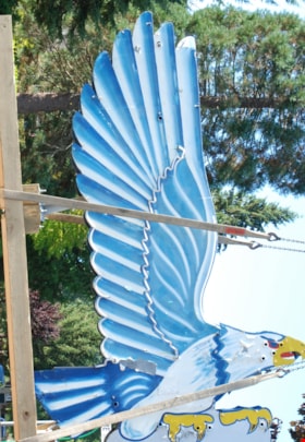
neon sign
https://search.heritageburnaby.ca/link/museumartifact86079
- Repository
- Burnaby Village Museum
- Accession Code
- BV016.18.2
- Description
- Eagle Ford neon sign. It is a large double-sided hollow sheet metal sign measuring 13.3 feet tall and 8.9 feet wide. The sheet metal and structure of the sign retains most of the eagle's original painted image, including the dramatic wings with their blue and white feather pattern.
- Object History
- Eagle Motors Limited was established by the well-known Burnaby businessman Frank McCracken at 4161 Hastings Street in 1948. The car dealership became a successful local Heights business and was the largest Ford car and truck retailer in the province during its operation. The company had adopted the silhouette of the classic Bald Eagle in full flight to serve as a logo which was utilized in advertising and promotional materials. The eagle symbol was famously developed into a classic chrome badge with the name "Eagle Ford - Burnaby, BC" that was installed on all the Eagle Ford cars and trucks sold by the dealership. After a new showroom building was constructed on the site in 1950, the company commissioned Neon Products of Vancouver to manufacture a very large double-sided neon eagle. Typical of neon signs of the era, the eagle was painted with dramatic designs and bright primary colours on metal with blue, white, and gold neon tubing serving to highlight the outline of the eagle.
- The "Burnaby Eagle" sign immediately became a landmark on the Burnaby Heights business district. From its high perch atop the dealership building, located at Carleton Street, the Burnaby Eagle shared the night sky with other nearby classic neon signs of the era including the "Swinging Girl" sign of the Helen's Children's Wear store. Eagle Motors was a successful dealership until the recession of the 1980s, and in 1985 the business was closed. Vandalism on the site resulted in damage to the neon tubing of the sign before the leased sign was reclaimed by its owner, Neon Products Limited. The sign was obtained by a local collector, who carefully looked after it for 25 years. In 2012, the sign was sold to the City of Burnaby.
- The sign will be restored and installed near its original location on Hastings Street in 2024.
- Reference
- Community Heritage Commission report to Council, September 17, 2012.
- Measurements
- Height: 14 ft. Width: 9 ft. Thickness: 14 in.
- Historic Neighbourhood
- Vancouver Heights (Historic Neighbourhood)
- Planning Study Area
- Burnaby Heights Area
Images

North Burnaby High School Graduates 1954
https://search.heritageburnaby.ca/link/museumdescription163
- Repository
- Burnaby Village Museum
- Date
- 1954
- Collection/Fonds
- Burnaby Village Museum Photograph collection
- Description Level
- Item
- Physical Description
- 1 photograph : b&w ; 36.5 x 58.5 cm mounted on board 76 x 101.5 cm
- Scope and Content
- Photograph of graduates of North Burnaby High School in 1954 with all names of graduates scripted on mounting board by E.Skrypec. Row 1: L. Fox, S. Johnson, R. Larson, B. Milaney, J. Watson, D. Spring, G. Calder, J. Forester, A. Nash, J. McGiveron, M. Meikle, T. Brooks, J. Meikle, S. Hill, B. Bil…
- Repository
- Burnaby Village Museum
- Collection/Fonds
- Burnaby Village Museum Photograph collection
- Description Level
- Item
- Physical Description
- 1 photograph : b&w ; 36.5 x 58.5 cm mounted on board 76 x 101.5 cm
- Scope and Content
- Photograph of graduates of North Burnaby High School in 1954 with all names of graduates scripted on mounting board by E.Skrypec. Row 1: L. Fox, S. Johnson, R. Larson, B. Milaney, J. Watson, D. Spring, G. Calder, J. Forester, A. Nash, J. McGiveron, M. Meikle, T. Brooks, J. Meikle, S. Hill, B. Bilson, F. Stewart, M. Slavin, H. Trayling, B. Bourne, M. Mothe, M. Bazylevich, S. Yorston, E. Underwood, S. Sandberg, A. Craig, A. Holzman, M. Cranston, W. Pendygrasse and L. Holland. Row 2: S. Willimas, S. Anderson, G. Burgess, I. Radill, J. Jopling, J. Wong, K. McNicol, D. Gallie, W. Brigden, I. Frank, J. Elliott, P. Wooldard, D. Drummond, E. Murray, K. Nelson, B. Smith, J. Purser, D. Lister, N. Husband, A. Ryder and G. Olafson. Row 3: B. Beaumont, W. Judyski, B. Chamberland, R. Dyck, H. Lunow, R. Morris, N. Trtan, S. Gill, K. Elliott, D. Demchuk, D. Wilson, H. Philbrook, D. Connorton, D. Panton, G. Monk, G. Kubicek, J. Christian, H. Pendygrasse, D. Norman and H. Peterson. Row 4: C. Allen, J. MacDonald, H. Siddoo, G. Boyd, G. Norgard, P. Iannucci, R. McDonnell, B. Mills, R. Ostby, K. Bennett, F. McAuley, G. Topham, G. Clapp, H. Rink, T. Scuffi, B. Dolman, L. Armstrong, W. Cross, E. Matiash and B. Miles. Row 5: V. Cinnamon, T. Saunders, E. Skrypec, S. Bonettemaker, G. Barr, W. Greba, B. Asleson, B. Launder, F. Punko, J. Maxwell, J. McTaggart, D. Allen, W. Plevy, J. Bailey and R. Zacharias.
- Subjects
- Persons - Students
- Persons - Chinese Canadians
- Events
- Buildings - Schools
- Persons - South Asian Canadians
- Geographic Access
- Pandora Street
- Street Address
- 4375 Pandora Street
- Accession Code
- BV985.30.1
- Access Restriction
- No restrictions
- Reproduction Restriction
- May be restricted by third party rights
- Date
- 1954
- Media Type
- Photograph
- Historic Neighbourhood
- Vancouver Heights (Historic Neighbourhood)
- Planning Study Area
- Burnaby Heights Area
- Notes
- Title based on contents of item
pail
https://search.heritageburnaby.ca/link/museumartifact89578
- Repository
- Burnaby Village Museum
- Accession Code
- BV018.31.9
- Description
- pail; large, steel "glucose" pail used at Valley Bakery; grey painted exterior, no lid, bail handle with opaque plastic grip; ca. 1950s; text stamped on bottom reads: "VULCAN / CTC-37C-80 / 28/26 79 / MADE IN CANADA / STC".
- Object History
- Object was used by donor at Valley Bakery, currently located at 4058 East Hastings Street, Valley Bakery opened in Burnaby in 1957 and is still owned and operated by the same family as of 2019.
- Category
- 04.Tools & Equipment for Materials
- Classification
- Food Processing & Preparation T&E - - Food Storage Equipment
- Object Term
- Container, Food Preparation
- Measurements
- H: 35.3 cm Dia.: 27.3 cm
- Historic Neighbourhood
- Vancouver Heights (Historic Neighbourhood)
- Planning Study Area
- Burnaby Heights Area
Images

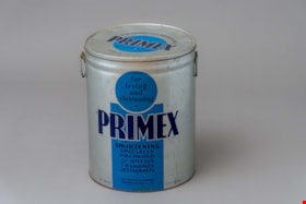
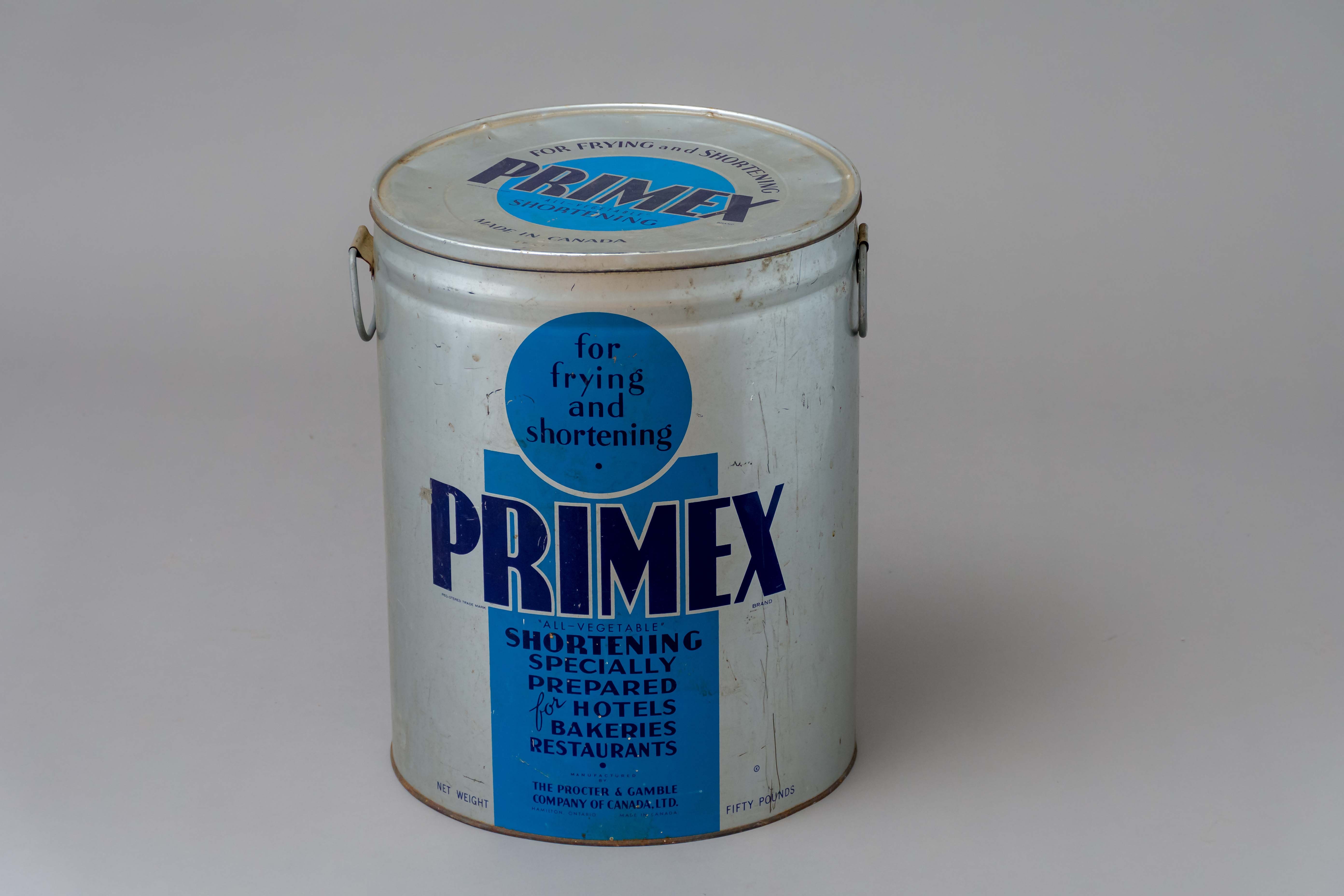
pail with lid
https://search.heritageburnaby.ca/link/museumartifact89579
- Repository
- Burnaby Village Museum
- Accession Code
- BV018.31.10
- Description
- pail; large, steel "shortening" pail used at Valley Bakery; silver painted exterior with blue graphics, circular steel lid, two loop handles on sides; ca. 1950s; text on sides reads: "for / frying / and / shortening / PRIMEX / "ALL-VEGETABLE" / SHORTENING / SPECIALLY / PREPARED / for HOTELS / BAKERIES / RESTAURANTS / MANUFACTURED / BY / THE PROCTER & GAMBLE / COMPANY OF CANADA LTD. / HAMILTON, ONTARIO MADE IN CANADA / NET WEIGHT FIFTY POUNDS".
- Object History
- Object was used by donor at Valley Bakery. Currently located at 4058 East Hastings Street, Valley Bakery opened in Burnaby in 1957 and is still owned and operated by the same family as of 2019.
- Category
- 04.Tools & Equipment for Materials
- Classification
- Food Processing & Preparation T&E - - Food Storage Equipment
- Object Term
- Container, Food Preparation
- Measurements
- L: 39.2 cm Dia.: 31.5 cm
- Names
- Valley Bakery
- Historic Neighbourhood
- Vancouver Heights (Historic Neighbourhood)
- Planning Study Area
- Burnaby Heights Area
Images

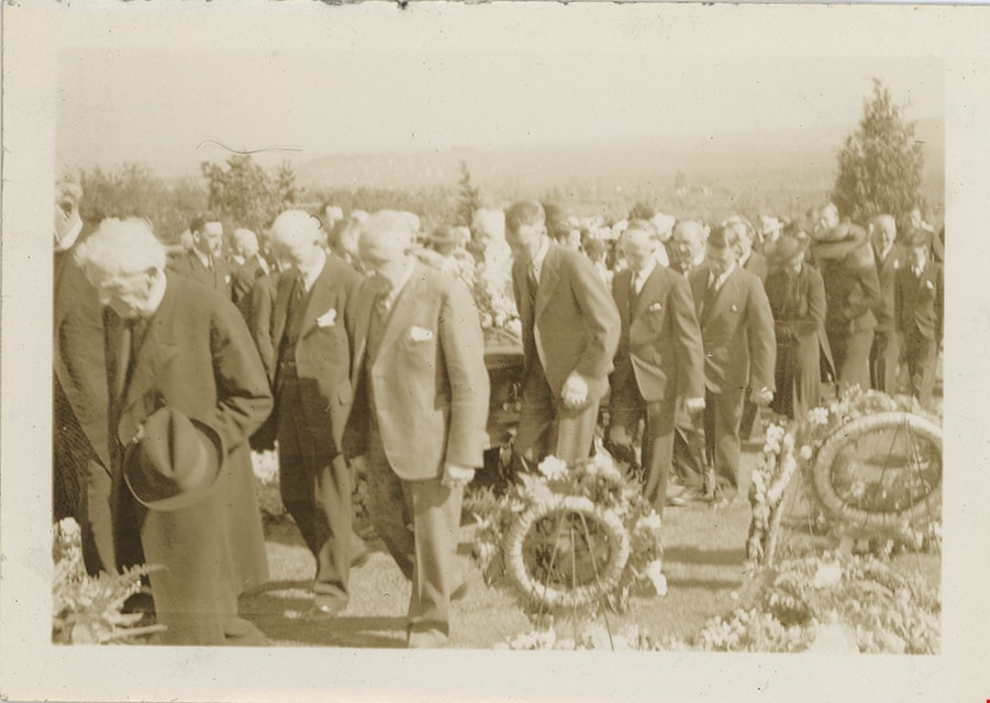
Pallbearers and procession in Masonic Cemetery
https://search.heritageburnaby.ca/link/museumdescription19460
- Repository
- Burnaby Village Museum
- Date
- 1937
- Collection/Fonds
- Hawkshaw family fonds
- Description Level
- Item
- Physical Description
- 1 photograph : sepia ; 6.5 x 9 cm
- Scope and Content
- Photograph of pallbearers and funeral procession in the Masonic Cemetery in Burnaby where Charles Woodward was laid to rest in the mausoleum of the Woodward family.
- Repository
- Burnaby Village Museum
- Collection/Fonds
- Hawkshaw family fonds
- Description Level
- Item
- Physical Description
- 1 photograph : sepia ; 6.5 x 9 cm
- Scope and Content
- Photograph of pallbearers and funeral procession in the Masonic Cemetery in Burnaby where Charles Woodward was laid to rest in the mausoleum of the Woodward family.
- Subjects
- Ceremonies - Funerals
- Accession Code
- BV996.6.166
- Access Restriction
- No restrictions
- Reproduction Restriction
- No known restrictions
- Date
- 1937
- Media Type
- Photograph
- Historic Neighbourhood
- Vancouver Heights (Historic Neighbourhood)
- Planning Study Area
- Willingdon Heights Area
- Scan Resolution
- 600
- Scan Date
- 2023-02-06
- Notes
- Title based on contents of photograph
- Caption on album page reads: "June 4 / 1937 / FURTHER ON"
- Photograph is part of photograph album BV996.6.1
Images
Pallbearers and procession in Masonic Cemetery
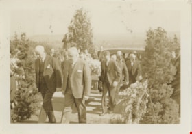
https://search.heritageburnaby.ca/link/museumdescription19461
- Repository
- Burnaby Village Museum
- Date
- 1937
- Collection/Fonds
- Hawkshaw family fonds
- Description Level
- Item
- Physical Description
- 1 photograph : sepia ; 6.5 x 9 cm
- Scope and Content
- Photograph of pallbearers and funeral procession in the Masonic Cemetery in Burnaby where Charles Woodward was laid to rest in the mausoleum of the Woodward family. The procession is leaving from the hearse into the cemetery.
- Repository
- Burnaby Village Museum
- Collection/Fonds
- Hawkshaw family fonds
- Description Level
- Item
- Physical Description
- 1 photograph : sepia ; 6.5 x 9 cm
- Scope and Content
- Photograph of pallbearers and funeral procession in the Masonic Cemetery in Burnaby where Charles Woodward was laid to rest in the mausoleum of the Woodward family. The procession is leaving from the hearse into the cemetery.
- Subjects
- Ceremonies - Funerals
- Accession Code
- BV996.6.167
- Access Restriction
- No restrictions
- Reproduction Restriction
- No known restrictions
- Date
- 1937
- Media Type
- Photograph
- Historic Neighbourhood
- Vancouver Heights (Historic Neighbourhood)
- Planning Study Area
- Willingdon Heights Area
- Scan Resolution
- 600
- Scan Date
- 2023-02-06
- Notes
- Title based on contents of photograph
- Caption on album page reads: "June 4 / 1937 / JUST LEAVING HEARSH"
- Photograph is part of photograph album BV996.6.1
Images

Pallbearers carrying coffin into mausoleum
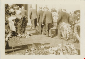
https://search.heritageburnaby.ca/link/museumdescription19462
- Repository
- Burnaby Village Museum
- Date
- 1937
- Collection/Fonds
- Hawkshaw family fonds
- Description Level
- Item
- Physical Description
- 1 photograph : sepia ; 6.5 x 9 cm
- Scope and Content
- Photograph of pallbearers carrying the coffin of Charles Woodward into the Woodward family mausoleum inside the Masonic Cemetery in Burnaby.
- Repository
- Burnaby Village Museum
- Collection/Fonds
- Hawkshaw family fonds
- Description Level
- Item
- Physical Description
- 1 photograph : sepia ; 6.5 x 9 cm
- Scope and Content
- Photograph of pallbearers carrying the coffin of Charles Woodward into the Woodward family mausoleum inside the Masonic Cemetery in Burnaby.
- Subjects
- Ceremonies - Funerals
- Accession Code
- BV996.6.168
- Access Restriction
- No restrictions
- Reproduction Restriction
- No known restrictions
- Date
- 1937
- Media Type
- Photograph
- Historic Neighbourhood
- Vancouver Heights (Historic Neighbourhood)
- Planning Study Area
- Willingdon Heights Area
- Scan Resolution
- 600
- Scan Date
- 2023-02-06
- Notes
- Title based on contents of photograph
- Caption on album page reads: "June 4 / 1937 / Just before the Vault"
- Photograph is part of photograph album BV996.6.1
Images

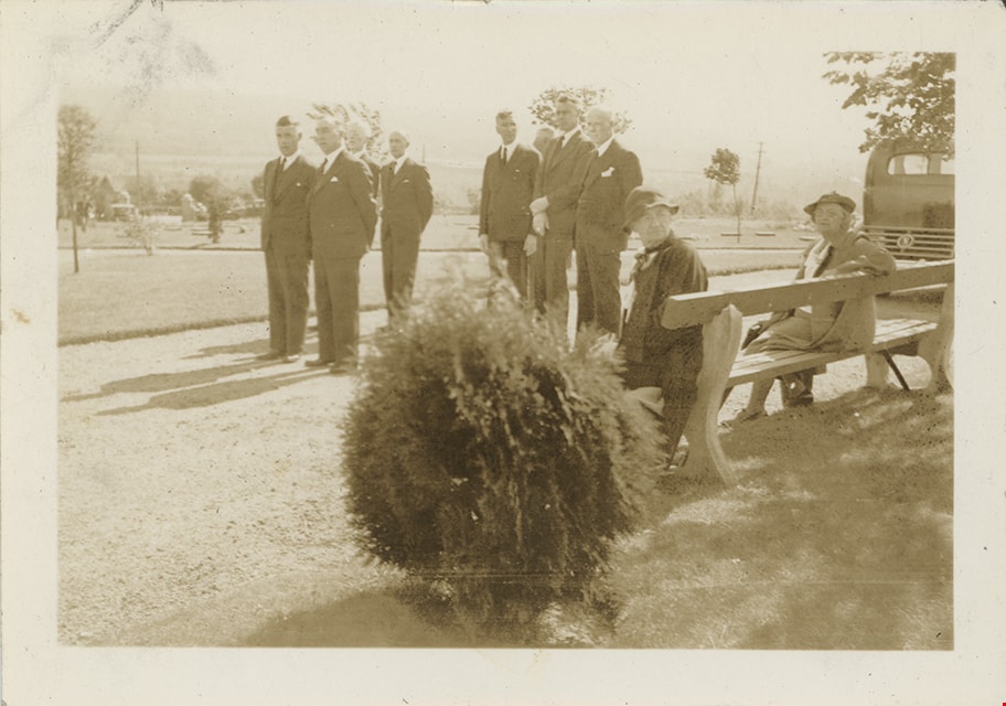
Pallbearers in Masonic Cemetery
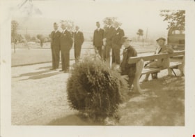
https://search.heritageburnaby.ca/link/museumdescription19459
- Repository
- Burnaby Village Museum
- Date
- 7 Jun. 1937
- Collection/Fonds
- Hawkshaw family fonds
- Description Level
- Item
- Physical Description
- 1 photograph : sepia ; 6.5 x 9 cm
- Scope and Content
- Photograph of six pallbearers standing in the Masonic Cemetery in Burnaby where Charles Woodward was laid to rest in the mausoleum of the Woodward family. Two women are seated on a bench.
- Repository
- Burnaby Village Museum
- Collection/Fonds
- Hawkshaw family fonds
- Description Level
- Item
- Physical Description
- 1 photograph : sepia ; 6.5 x 9 cm
- Scope and Content
- Photograph of six pallbearers standing in the Masonic Cemetery in Burnaby where Charles Woodward was laid to rest in the mausoleum of the Woodward family. Two women are seated on a bench.
- Subjects
- Ceremonies - Funerals
- Accession Code
- BV996.6.165
- Access Restriction
- No restrictions
- Reproduction Restriction
- No known restrictions
- Date
- 7 Jun. 1937
- Media Type
- Photograph
- Historic Neighbourhood
- Vancouver Heights (Historic Neighbourhood)
- Planning Study Area
- Willingdon Heights Area
- Scan Resolution
- 600
- Scan Date
- 2023-02-06
- Notes
- Title based on contents of photograph
- Caption on album page reads: "June 4 / 1937 / PALL BEARES"
- Photograph is part of photograph album BV996.6.1
Images
![Parade float, [ca. 1960] thumbnail](/media/hpo/_Data/_BVM_Images/2015/2015_0035_0289_001.jpg?width=280)
Parade float
https://search.heritageburnaby.ca/link/museumdescription4953
- Repository
- Burnaby Village Museum
- Date
- [ca. 1960]
- Collection/Fonds
- Burnaby Girl Guides fonds
- Description Level
- Item
- Physical Description
- 1 photograph : b&w 7 x 9.5 cm
- Scope and Content
- Photograph of unidentified members of 4th Burnaby Guide Company seated on a parade float. The parade float is decorated with sprites, cedar boughs and a canvas tent while going down a residential street in North Burnaby.
- Repository
- Burnaby Village Museum
- Collection/Fonds
- Burnaby Girl Guides fonds
- Description Level
- Item
- Physical Description
- 1 photograph : b&w 7 x 9.5 cm
- Scope and Content
- Photograph of unidentified members of 4th Burnaby Guide Company seated on a parade float. The parade float is decorated with sprites, cedar boughs and a canvas tent while going down a residential street in North Burnaby.
- Other Title Information
- Title based on contents of photograph
- Names
- Girl Guides of Canada
- Accession Code
- BV015.35.289
- Access Restriction
- No restrictions
- Reproduction Restriction
- May be restricted by third party rights
- Date
- [ca. 1960]
- Media Type
- Photograph
- Historic Neighbourhood
- Vancouver Heights (Historic Neighbourhood)
- Planning Study Area
- Burnaby Heights Area
- Scan Resolution
- 600
- Scan Date
- 05/11/2018
- Notes
- Photograph is part of scrapbook BV015.35.166
Images
![Parade float, [ca. 1960] thumbnail](/media/hpo/_Data/_BVM_Images/2015/2015_0035_0289_001.jpg)
![Paved road, [1948] thumbnail](/media/hpo/_Data/_BVM_Images/1971/1971_0012_0087_001.jpg?width=280)
Paved road
https://search.heritageburnaby.ca/link/museumdescription19
- Repository
- Burnaby Village Museum
- Date
- [1948]
- Collection/Fonds
- Burnaby Village Museum Photograph collection
- Description Level
- Item
- Physical Description
- 1 photograph : sepia ; 6.8 x 11.4 cm
- Scope and Content
- Photograph of a paved road running through a cleared lot. There is an electric post on the roadside, and woods in the background. Catalogue information from 1976 indicates that it is a street development in Burnaby, ca. 1948. This may be the site of the Willingdon Heights subdivision. Annotation o…
- Repository
- Burnaby Village Museum
- Collection/Fonds
- Burnaby Village Museum Photograph collection
- Description Level
- Item
- Physical Description
- 1 photograph : sepia ; 6.8 x 11.4 cm
- Scope and Content
- Photograph of a paved road running through a cleared lot. There is an electric post on the roadside, and woods in the background. Catalogue information from 1976 indicates that it is a street development in Burnaby, ca. 1948. This may be the site of the Willingdon Heights subdivision. Annotation on lower right front of photograph: "26." Stamped on back of photograph: "321X."
- Subjects
- Geographic Features - Roads
- Land Clearing
- Names
- Bingham, Alfred "Alf"
- Accession Code
- HV971.12.87
- Access Restriction
- No restrictions
- Reproduction Restriction
- No known restrictions
- Date
- [1948]
- Media Type
- Photograph
- Historic Neighbourhood
- Vancouver Heights (Historic Neighbourhood)
- Planning Study Area
- Willingdon Heights Area
- Scan Resolution
- 600
- Scan Date
- 2023-03-21
- Notes
- Title based on contents of photograph
Images
![Paved road, [1948] thumbnail](/media/hpo/_Data/_BVM_Images/1971/1971_0012_0087_001.jpg)