Narrow Results By
Subject
- Accidents 1
- Accidents - Automobile Accidents 1
- Advertising Medium - Signs and Signboards 1
- Buildings - Commercial - Train Stations 3
- Buildings - Residential - Houses 1
- Buildings - Schools 2
- Construction 3
- Construction Tools and Equipment 2
- Emergency Services - Ambulance Services 1
- Furniture 1
- Geographic Features - Creeks 1
- Geographic Features - Lakes and Ponds 1

D.C. Patterson House
https://search.heritageburnaby.ca/link/landmark517
- Repository
- Burnaby Heritage Planning
- Description
- The D.C. Patterson House is a one and one-half storey plus basement wood-frame Edwardian era residence with a full-width front verandah and symmetrical saddlebag dormers. It is located adjacent to a ravine park and is part of the Winston Gate development.
- Associated Dates
- 1910
- Formal Recognition
- Heritage Designation, Community Heritage Register
- Other Names
- Dugald & Frances Patterson House
- Street View URL
- Google Maps Street View
- Repository
- Burnaby Heritage Planning
- Other Names
- Dugald & Frances Patterson House
- Geographic Access
- 12th Avenue
- Associated Dates
- 1910
- Formal Recognition
- Heritage Designation, Community Heritage Register
- Enactment Type
- Bylaw No. 10062
- Enactment Date
- 11/07/1994
- Description
- The D.C. Patterson House is a one and one-half storey plus basement wood-frame Edwardian era residence with a full-width front verandah and symmetrical saddlebag dormers. It is located adjacent to a ravine park and is part of the Winston Gate development.
- Heritage Value
- This house is significant for its associations with the Patterson family, who were early Burnaby pioneers. Dugald Campbell Patterson (1860-1931) and Frances Mabel Patterson (1872-1960) arrived in 1894 and settled in the Central Park district. In 1910, they relocated to the Edmonds District and built this family residence on Edmonds Street near Kingsway. The Pattersons were community minded citizens who served Burnaby through their involvement with local municipal affairs and politics. Dugald Patterson served as a School Trustee in 1912-13 and was one of the first residents to lobby council to preserve the local ravines as parks. The family name is remembered and honoured by the naming of Patterson Avenue and the Patterson SkyTrain Station located in the Metrotown area. Additionally, the D.C. Patterson House is significant as a fine example of a vernacular Edwardian era family house. The typical design of the Patterson House was taken from an Edwardian era pattern book, and demonstrates how standardized plans were commonly used by local owners and builders to expedite the construction process. This house has survived in an excellent state of preservation. Although moved from its original site, it remains as an intact representation of a middle-class Burnaby residence of the Edwardian era.
- Defining Elements
- Key elements that define the heritage character of the D.C. Patterson House include its: - vernacular residential form, scale and massing as exemplified by its one and one-half storey plus basement height, front gabled roof with hipped return over front verandah, symmetrical saddlebag dormers and rectangular, side hall plan with an asymmetrical front entry - typical Edwardian era construction features such as the deep boxed eaves, lapped wooden siding and cedar shingle roofing - projecting front gable peak, clad in decorative random-coursed square shingles, with eave brackets under and a louvered attic vent - projecting elements on the main floor including a square bay on the east side and a semi-octagonal bay to the west side - full-width open front verandah with irregularly-spaced square columns - closed balustrades with drainage scuppers on the front verandah and rear side porch - regular fenestration, including double hung 1-over-1 wooden-sash windows with proportionately smaller upper sash, triple assembly of windows in the front gable, and leaded glass in main floor front window - original front door with inset bevelled glass light
- Historic Neighbourhood
- Edmonds (Historic Neighbourhood)
- Planning Study Area
- Stride Hill Area
- Function
- Primary Historic--Single Dwelling
- Primary Current--Single Dwelling
- Community
- Burnaby
- Cadastral Identifier
- 003-008-321
- Boundaries
- The D.C. Patterson House is comprised of a single residential lot located at 7106 Eighteenth Avenue, Burnaby.
- Area
- 5176
- Contributing Resource
- Building
- Ownership
- Private
- Street Address
- 7106 18th Avenue
- Street View URL
- Google Maps Street View
Images


Murphy Residence
https://search.heritageburnaby.ca/link/landmark623
- Repository
- Burnaby Heritage Planning
- Description
- Residential building.
- Associated Dates
- 1913
- Street View URL
- Google Maps Street View
- Repository
- Burnaby Heritage Planning
- Geographic Access
- Gilley Avenue
- Associated Dates
- 1913
- Description
- Residential building.
- Heritage Value
- This bungalow was built for Joshua Robert Murphy (1861-1920), a mill superintendent, and his wife Elizabeth Ann (née Delby, 1871-1956). The Murphys lived in the house at least until Joshua’s death in 1920. A bellcast side gabled roof and central bellcast dormer accentuate the sophisticated construction. A full width verandah supported by tapered columns on tapered granite piers graces the front of the house. Originally, the dormer held an open sleeping porch with a segmental arch supported by short tapered columns matching those below. Despite this alteration, the house is otherwise in substantially original condition.
- Locality
- Alta Vista
- Historic Neighbourhood
- Alta Vista (Historic Neighbourhood)
- Planning Study Area
- Stride Hill Area
- Area
- 1567.37
- Contributing Resource
- Building
- Ownership
- Private
- Street Address
- 8610 Gilley Avenue
- Street View URL
- Google Maps Street View
Images


Stride Hill Neighbourhood
https://search.heritageburnaby.ca/link/landmark846
- Repository
- Burnaby Heritage Planning
- Associated Dates
- 1955-2008
- Heritage Value
- The residential areas that are located within the Stride Hill Neighbourhood were primarily developed in the 1950s during Burnaby's post-war building boom. The area lying to the south of Byrne Creek Ravine Park was used as a municipal garbage dump until the 1960s and as a landfill site for yard waste disposal until the early 1990s at which point the area was incorporated into the Edmonds Town Centre Plan and the land was made into park and open space.
- Historic Neighbourhood
- Edmonds (Historic Neighbourhood)
- Planning Study Area
- Stride Hill Area
Images


Taylor Park Elementary School
https://search.heritageburnaby.ca/link/landmark847
- Repository
- Burnaby Heritage Planning
- Geographic Access
- Mission Avenue
- Associated Dates
- 2004
- Heritage Value
- Taylor Park Elementary School was opened in 2004 with 240 students from kindergarten to grade three (with older students attending Stride Avenue Community School). By 2006, Taylor Park had been designated as its own school and extended its classes from kindergarten through grade six.
- Historic Neighbourhood
- Edmonds (Historic Neighbourhood)
- Planning Study Area
- Stride Hill Area
- Street Address
- 7590 Mission Avenue
- Street View URL
- Google Maps Street View
Images

1000 Block Gilley Avenue
https://search.heritageburnaby.ca/link/archivedescription38085
- Repository
- City of Burnaby Archives
- Date
- [1955] (date of original), copied 1991
- Collection/Fonds
- Burnaby Historical Society fonds
- Description Level
- Item
- Physical Description
- 1 photograph : b&w ; 3.1 x 3.0 cm print on contact sheet 21.5 x 26.8 cm
- Scope and Content
- Photograph of the 1000 block of Gilley Avenue (later renumbered the 8000 block) looking south towards Marine Drive in the snow.
- Repository
- City of Burnaby Archives
- Date
- [1955] (date of original), copied 1991
- Collection/Fonds
- Burnaby Historical Society fonds
- Subseries
- Burnaby Image Bank subseries
- Physical Description
- 1 photograph : b&w ; 3.1 x 3.0 cm print on contact sheet 21.5 x 26.8 cm
- Description Level
- Item
- Record No.
- 370-672
- Access Restriction
- No restrictions
- Reproduction Restriction
- No restrictions
- Accession Number
- BHS1999-03
- Scope and Content
- Photograph of the 1000 block of Gilley Avenue (later renumbered the 8000 block) looking south towards Marine Drive in the snow.
- Media Type
- Photograph
- Notes
- Title based on contents of photograph
- 1 b&w copy negative accompanying
- Negative has a pink cast
- Geographic Access
- Gilley Avenue
- Planning Study Area
- Clinton-Glenwood Area
- Stride Hill Area
Images
![1007 Gilley Avenue, [1949 or 1950] (date of original), copied 1991 thumbnail](/media/hpo/_Data/_Archives_Images/_Unrestricted/370/370-667.jpg?width=280)
1007 Gilley Avenue
https://search.heritageburnaby.ca/link/archivedescription38080
- Repository
- City of Burnaby Archives
- Date
- [1949 or 1950] (date of original), copied 1991
- Collection/Fonds
- Burnaby Historical Society fonds
- Description Level
- Item
- Physical Description
- 1 photograph : b&w ; 3.0 x 3.0 cm print on contact sheet 20.2 x 26.2 cm
- Scope and Content
- Photograph of the back of 1007 Gilley Avenue (later renumbered 8416 Gilley Avenue).
- Repository
- City of Burnaby Archives
- Date
- [1949 or 1950] (date of original), copied 1991
- Collection/Fonds
- Burnaby Historical Society fonds
- Subseries
- Burnaby Image Bank subseries
- Physical Description
- 1 photograph : b&w ; 3.0 x 3.0 cm print on contact sheet 20.2 x 26.2 cm
- Description Level
- Item
- Record No.
- 370-667
- Access Restriction
- No restrictions
- Reproduction Restriction
- No restrictions
- Accession Number
- BHS1999-03
- Scope and Content
- Photograph of the back of 1007 Gilley Avenue (later renumbered 8416 Gilley Avenue).
- Subjects
- Buildings - Residential - Houses
- Media Type
- Photograph
- Notes
- Title based on contents of photograph
- 1 b&w copy negative accompanying
- Negative has a pink cast
- Geographic Access
- Gilley Avenue
- Street Address
- 8416 Gilley Avenue
- Planning Study Area
- Stride Hill Area
Images
![1007 Gilley Avenue, [1949 or 1950] (date of original), copied 1991 thumbnail](/media/hpo/_Data/_Archives_Images/_Unrestricted/370/370-667.jpg)
6850 20th Avenue
https://search.heritageburnaby.ca/link/archivedescription93728
- Repository
- City of Burnaby Archives
- Date
- March 1989
- Collection/Fonds
- Grover, Elliott & Co. Ltd. fonds
- Description Level
- File
- Physical Description
- 31 photographs : col. negatives ; 35 mm
- Scope and Content
- Photographs of an industrial property located at 6850 20th Avenue during construction. 6850 20th Avenue is an address that no longer exists.
- Repository
- City of Burnaby Archives
- Date
- March 1989
- Collection/Fonds
- Grover, Elliott & Co. Ltd. fonds
- Physical Description
- 31 photographs : col. negatives ; 35 mm
- Description Level
- File
- Record No.
- 622-016
- Access Restriction
- No restrictions
- Reproduction Restriction
- No restrictions
- Accession Number
- 2017-39
- Scope and Content
- Photographs of an industrial property located at 6850 20th Avenue during construction. 6850 20th Avenue is an address that no longer exists.
- Media Type
- Photograph
- Notes
- Transcribed title
- Title transcribed from original print envelope
- Geographic Access
- 20th Avenue
- Planning Study Area
- Stride Hill Area
![Anne and Evelyn Le Grove, [1956] (date of original), copied 1991 thumbnail](/media/hpo/_Data/_Archives_Images/_Unrestricted/370/370-630.jpg?width=280)
Anne and Evelyn Le Grove
https://search.heritageburnaby.ca/link/archivedescription38043
- Repository
- City of Burnaby Archives
- Date
- [1956] (date of original), copied 1991
- Collection/Fonds
- Burnaby Historical Society fonds
- Description Level
- Item
- Physical Description
- 1 photograph : b&w ; 3.2 x 3.0 cm print on contact sheet 20.2 x 26.6 cm
- Scope and Content
- Photograph of Anne and Evelyn Le Grove washing dishes in the kitchen of 1007 Gilley Avenue (later renumbered 8416 Gilley Avenue).
- Repository
- City of Burnaby Archives
- Date
- [1956] (date of original), copied 1991
- Collection/Fonds
- Burnaby Historical Society fonds
- Subseries
- Burnaby Image Bank subseries
- Physical Description
- 1 photograph : b&w ; 3.2 x 3.0 cm print on contact sheet 20.2 x 26.6 cm
- Description Level
- Item
- Record No.
- 370-630
- Access Restriction
- No restrictions
- Reproduction Restriction
- No restrictions
- Accession Number
- BHS1999-03
- Scope and Content
- Photograph of Anne and Evelyn Le Grove washing dishes in the kitchen of 1007 Gilley Avenue (later renumbered 8416 Gilley Avenue).
- Media Type
- Photograph
- Notes
- Title based on contents of photograph
- 1 b&w copy negative accompanying
- Negative has a pink cast
- Geographic Access
- Gilley Avenue
- Street Address
- 8416 Gilley Avenue
- Planning Study Area
- Stride Hill Area
Images
![Anne and Evelyn Le Grove, [1956] (date of original), copied 1991 thumbnail](/media/hpo/_Data/_Archives_Images/_Unrestricted/370/370-630.jpg)
![Bombardier SkyTrain manufacturing facility, [2000] thumbnail](/media/hpo/_Data/_Archives_Images/_Unrestricted/535/535-2108-1.jpg?width=280)
Bombardier SkyTrain manufacturing facility
https://search.heritageburnaby.ca/link/archivedescription96484
- Repository
- City of Burnaby Archives
- Date
- [2000]
- Collection/Fonds
- Burnaby NewsLeader photograph collection
- Description Level
- File
- Physical Description
- 2 photographs (tiff) : col.
- Scope and Content
- File contains photographs of Pierre Hebert, the plant manager at Bombardier's new SkyTrain manufacturing facility in Burnaby. Photographs depict Hebert posing with the shell of a new SkyTrain car and inspecting the inside of the under-construction car.
- Repository
- City of Burnaby Archives
- Date
- [2000]
- Collection/Fonds
- Burnaby NewsLeader photograph collection
- Physical Description
- 2 photographs (tiff) : col.
- Description Level
- File
- Record No.
- 535-2108
- Access Restriction
- No restrictions
- Reproduction Restriction
- No restrictions
- Accession Number
- 2018-12
- Scope and Content
- File contains photographs of Pierre Hebert, the plant manager at Bombardier's new SkyTrain manufacturing facility in Burnaby. Photographs depict Hebert posing with the shell of a new SkyTrain car and inspecting the inside of the under-construction car.
- Subjects
- Transportation - Skytrain
- Construction
- Media Type
- Photograph
- Photographer
- Bartel, Mario
- Notes
- Title based on caption
- Collected by editorial for use in a March 2000 issue of the Burnaby NewsLeader
- Caption from metadata for 535-2108-1: "Pierre Hebert, the plant manager at Bombardier's new Burnaby facility, with one of the shells for the new Skytrain cars being built at the plant."
- Caption from metadata for 535-2108-2: "Pierre Hebert, plant manager at Bombardier's new Skytrain manufacturing facility in Burnaby, inspects the hollow shell of one of the new series of cars to be built at the plant."
- Geographic Access
- 10th Avenue
- Historic Neighbourhood
- Edmonds (Historic Neighbourhood)
- Planning Study Area
- Stride Hill Area
Images
![Bombardier SkyTrain manufacturing facility, [2000] thumbnail](/media/hpo/_Data/_Archives_Images/_Unrestricted/535/535-2108-1.jpg)
![Byrne Creek ravine rescue, [2001] thumbnail](/media/hpo/_Data/_Archives_Images/_Unrestricted/535/535-2253-2.jpg?width=280)
Byrne Creek ravine rescue
https://search.heritageburnaby.ca/link/archivedescription96631
- Repository
- City of Burnaby Archives
- Date
- [2001]
- Collection/Fonds
- Burnaby NewsLeader photograph collection
- Description Level
- File
- Physical Description
- 3 photographs (tiff) : col.
- Scope and Content
- File contains photographs from a rescue operation undertaken by Burnaby fire fighters, paramedics, and other personnel in the Byrne Creek ravine.
- Repository
- City of Burnaby Archives
- Date
- [2001]
- Collection/Fonds
- Burnaby NewsLeader photograph collection
- Physical Description
- 3 photographs (tiff) : col.
- Description Level
- File
- Record No.
- 535-2253
- Access Restriction
- No restrictions
- Reproduction Restriction
- No restrictions
- Accession Number
- 2018-12
- Scope and Content
- File contains photographs from a rescue operation undertaken by Burnaby fire fighters, paramedics, and other personnel in the Byrne Creek ravine.
- Names
- Burnaby Fire Department
- Media Type
- Photograph
- Photographer
- Bartel, Mario
- Notes
- Title based on caption
- Collected by editorial for use in an April 2001 issue of the Burnaby NewsLeader
- Caption from metadata for 535-2253-1: "Burnaby firefighters from the Technical Rescue squad lift Yegor Rabbets, 13, from the Byrne Creek ravine, near MacLean Park, after he had fallen from a swinging rope, breaking bones and suffering possible internal injuries.
- Caption from metadata for 535-2253-2: "Rescue workers and paramedics load Yegor Rabbets, 13, into an air ambulance for transportation to BC Children's Hospital, after he had fallen from a swinging rope in the Byrne Creek ravine near MacLean Park, breaking bones and suffering possible internal injuries."
- Caption from metadata for 535-2253-3: "Alex Efremov, 14, helped guide rescue workers into the Byrne Creek ravine near MacLean Park, where his friend, Yegor Rabbets, 13, had fallen from a swinging rope, breaking bones and suffering possible internal injuries."
- Geographic Access
- Byrne Creek
- Historic Neighbourhood
- Edmonds (Historic Neighbourhood)
- Planning Study Area
- Stride Hill Area
Images
![Byrne Creek ravine rescue, [2001] thumbnail](/media/hpo/_Data/_Archives_Images/_Unrestricted/535/535-2253-2.jpg)
![Byrne Creek Streamkeepers, [2001] thumbnail](/media/hpo/_Data/_Archives_Images/_Unrestricted/535/535-2194-1.jpg?width=280)
Byrne Creek Streamkeepers
https://search.heritageburnaby.ca/link/archivedescription96572
- Repository
- City of Burnaby Archives
- Date
- [2001]
- Collection/Fonds
- Burnaby NewsLeader photograph collection
- Description Level
- File
- Physical Description
- 2 photographs (tiff) : col.
- Scope and Content
- File contains members of the Byrne Creek Streamkeepers during their work to protect the waterways and salmon in the area. Photographs depict Bob Fuller checking a waterflow measuring gauge and Joan Carne standing in the overflow channel at the salmon rearing ponds below Marine Drive.
- Repository
- City of Burnaby Archives
- Date
- [2001]
- Collection/Fonds
- Burnaby NewsLeader photograph collection
- Physical Description
- 2 photographs (tiff) : col.
- Description Level
- File
- Record No.
- 535-2194
- Access Restriction
- No restrictions
- Reproduction Restriction
- No restrictions
- Accession Number
- 2018-12
- Scope and Content
- File contains members of the Byrne Creek Streamkeepers during their work to protect the waterways and salmon in the area. Photographs depict Bob Fuller checking a waterflow measuring gauge and Joan Carne standing in the overflow channel at the salmon rearing ponds below Marine Drive.
- Subjects
- Persons - Volunteers
- Geographic Features - Creeks
- Geographic Features - Lakes and Ponds
- Geographic Features - Streams
- Media Type
- Photograph
- Photographer
- Bartel, Mario
- Notes
- Title based on caption
- Collected by editorial for use in a March 2001 issue of the Burnaby NewsLeader
- Caption from metadata for 535-2194-1: "Bob Fuller, of the Byrne Creek Streamkeepers, checks the guage that measures the flow of water which is released from the holding pond below Marine Drive to the salmon spawning beds downstream."
- Caption from metadata for 535-2194-2: "Joan Carne of the Byrne Creek Streamkeepers stands in the overflow channel at the salmon rearing ponds below Marine Drive. Although last week's chemical spill into Byrne Creek didn't reach the ponds, Carne says it's a constant battle to educate people to take care of the area's creeks and streams."
- Geographic Access
- Marine Drive
- Byrne Creek
- Planning Study Area
- Stride Hill Area
Images
![Byrne Creek Streamkeepers, [2001] thumbnail](/media/hpo/_Data/_Archives_Images/_Unrestricted/535/535-2194-1.jpg)
![Children and Youth at Gilley Avenue, [ca. 1956] (date of original), copied 1991 thumbnail](/media/hpo/_Data/_Archives_Images/_Unrestricted/370/370-629.jpg?width=280)
Children and Youth at Gilley Avenue
https://search.heritageburnaby.ca/link/archivedescription38042
- Repository
- City of Burnaby Archives
- Date
- [ca. 1956] (date of original), copied 1991
- Collection/Fonds
- Burnaby Historical Society fonds
- Description Level
- Item
- Physical Description
- 1 photograph : b&w ; 3.0 x 3.0 cm print on contact sheet 20.2 x 26.6 cm
- Scope and Content
- Photograph of a group of children and youth seated on a car at the back of 1007 Gilley Avenue (later renumbered 8416 Gilley Avenue). Left to right: Cheryl Clark, Beth Le Grove, [first name unknown] Clark, Dale Le Grove, and Anne Le Grove.
- Repository
- City of Burnaby Archives
- Date
- [ca. 1956] (date of original), copied 1991
- Collection/Fonds
- Burnaby Historical Society fonds
- Subseries
- Burnaby Image Bank subseries
- Physical Description
- 1 photograph : b&w ; 3.0 x 3.0 cm print on contact sheet 20.2 x 26.6 cm
- Description Level
- Item
- Record No.
- 370-629
- Access Restriction
- No restrictions
- Reproduction Restriction
- No restrictions
- Accession Number
- BHS1999-03
- Scope and Content
- Photograph of a group of children and youth seated on a car at the back of 1007 Gilley Avenue (later renumbered 8416 Gilley Avenue). Left to right: Cheryl Clark, Beth Le Grove, [first name unknown] Clark, Dale Le Grove, and Anne Le Grove.
- Subjects
- Transportation - Automobiles
- Media Type
- Photograph
- Notes
- Title based on contents of photograph
- 1 b&w copy negative accompanying
- Negative has a pink cast
- Geographic Access
- Gilley Avenue
- Street Address
- 8416 Gilley Avenue
- Planning Study Area
- Stride Hill Area
Images
![Children and Youth at Gilley Avenue, [ca. 1956] (date of original), copied 1991 thumbnail](/media/hpo/_Data/_Archives_Images/_Unrestricted/370/370-629.jpg)
![Dan Johnston at Taylor Park site, [2003] thumbnail](/media/hpo/_Data/_Archives_Images/_Unrestricted/535/535-2035.jpg?width=280)
Dan Johnston at Taylor Park site
https://search.heritageburnaby.ca/link/archivedescription96354
- Repository
- City of Burnaby Archives
- Date
- [2003]
- Collection/Fonds
- Burnaby NewsLeader photograph collection
- Description Level
- Item
- Physical Description
- 1 photograph (tiff) : col.
- Scope and Content
- Photograph of Burnaby Parks Commissioner Dan Johnston at the southwest view on Southpoint Drive at the area of an old landfill that is now Taylor Park.
- Repository
- City of Burnaby Archives
- Date
- [2003]
- Collection/Fonds
- Burnaby NewsLeader photograph collection
- Physical Description
- 1 photograph (tiff) : col.
- Description Level
- Item
- Record No.
- 535-2035
- Access Restriction
- No restrictions
- Reproduction Restriction
- No restrictions
- Accession Number
- 2018-12
- Scope and Content
- Photograph of Burnaby Parks Commissioner Dan Johnston at the southwest view on Southpoint Drive at the area of an old landfill that is now Taylor Park.
- Names
- Johnston, Dan
- Media Type
- Photograph
- Photographer
- Bartel, Mario
- Notes
- Title based on caption
- Collected by editorial for use in a February 2003 issue of the Burnaby NewsLeader
- Caption from metadata: "Burnaby Parks Commissioner, Dan Johnston, admires the view to the southwest from one of the lookouts to be integrated into the city's plans for Taylor Park, on Southpoint Drive. The park, to be built on an old landfill, will also include trails, a playground, meadows and an off-leash area for dogs."
- Geographic Access
- Southpoint Drive
- Historic Neighbourhood
- Edmonds (Historic Neighbourhood)
- Planning Study Area
- Stride Hill Area
Images
![Dan Johnston at Taylor Park site, [2003] thumbnail](/media/hpo/_Data/_Archives_Images/_Unrestricted/535/535-2035.jpg)
![Dolores Dyck, Helen Silvanovicz and Norma Rypdal, [1944] (date of original), copied 1992 thumbnail](/media/hpo/_Data/_Archives_Images/_Unrestricted/315/315-310.jpg?width=280)
Dolores Dyck, Helen Silvanovicz and Norma Rypdal
https://search.heritageburnaby.ca/link/archivedescription36852
- Repository
- City of Burnaby Archives
- Date
- [1944] (date of original), copied 1992
- Collection/Fonds
- Burnaby Historical Society fonds
- Description Level
- Item
- Physical Description
- 1 photograph : b&w ; 8 x 12 cm print
- Scope and Content
- Photograph of Dolores Dyck, Helen Silvanovicz and Norma Rypdal at the Connaught Hill Interurban tram station on their way to Burnaby South High School.
- Repository
- City of Burnaby Archives
- Date
- [1944] (date of original), copied 1992
- Collection/Fonds
- Burnaby Historical Society fonds
- Subseries
- Burnaby Centennial Anthology subseries
- Physical Description
- 1 photograph : b&w ; 8 x 12 cm print
- Description Level
- Item
- Record No.
- 315-310
- Access Restriction
- No restrictions
- Reproduction Restriction
- No known restrictions
- Accession Number
- BHS1994-04
- Scope and Content
- Photograph of Dolores Dyck, Helen Silvanovicz and Norma Rypdal at the Connaught Hill Interurban tram station on their way to Burnaby South High School.
- Names
- Dyck, Dolores
- Moysiuk, Helen Silvanovicz
- Perry, Norma Rypdal
- British Columbia Electric Railway Company
- Media Type
- Photograph
- Notes
- Title based on contents of photograph;
- Geographic Access
- Central Park Interurban line
- Historic Neighbourhood
- Fraser Arm (Historic Neighbourhood)
- Planning Study Area
- Stride Hill Area
- Stride Avenue Area
Images
![Dolores Dyck, Helen Silvanovicz and Norma Rypdal, [1944] (date of original), copied 1992 thumbnail](/media/hpo/_Data/_Archives_Images/_Unrestricted/315/315-310.jpg)
![Edmonds SkyTrain station accident, [2000] thumbnail](/media/hpo/_Data/_Archives_Images/_Unrestricted/535/535-1603.jpg?width=280)
Edmonds SkyTrain station accident
https://search.heritageburnaby.ca/link/archivedescription95745
- Repository
- City of Burnaby Archives
- Date
- [2000]
- Collection/Fonds
- Burnaby NewsLeader photograph collection
- Description Level
- Item
- Physical Description
- 1 photograph (tiff) : col.
- Scope and Content
- Photograph of two RCMP officers filling a bag with belongings of a victim after an accident. The 106 Metrotown Station bus is visible in the background.
- Repository
- City of Burnaby Archives
- Date
- [2000]
- Collection/Fonds
- Burnaby NewsLeader photograph collection
- Physical Description
- 1 photograph (tiff) : col.
- Description Level
- Item
- Record No.
- 535-1603
- Access Restriction
- No restrictions
- Reproduction Restriction
- No restrictions
- Accession Number
- 2018-12
- Scope and Content
- Photograph of two RCMP officers filling a bag with belongings of a victim after an accident. The 106 Metrotown Station bus is visible in the background.
- Media Type
- Photograph
- Photographer
- Bartel, Mario
- Notes
- Title based on caption
- Collected by editorial for use in a December 2000 issue of the Burnaby NewsLeader
- Caption from metadata: "Burnaby RCMP pack up the belongings of a pedestrian who was struck and killed by a BC Transit bus Monday morning, at the entrance to the Edmonds Skytrain station."
- Geographic Access
- 18th Avenue
- Historic Neighbourhood
- Edmonds (Historic Neighbourhood)
- Planning Study Area
- Stride Hill Area
Images
![Edmonds SkyTrain station accident, [2000] thumbnail](/media/hpo/_Data/_Archives_Images/_Unrestricted/535/535-1603.jpg)
![Fraser Arms Interurban station, [1930] (date of original), copied 1986 thumbnail](/media/hpo/_Data/_Archives_Images/_Unrestricted/204/204-368.jpg?width=280)
Fraser Arms Interurban station
https://search.heritageburnaby.ca/link/archivedescription35510
- Repository
- City of Burnaby Archives
- Date
- [1930] (date of original), copied 1986
- Collection/Fonds
- Burnaby Historical Society fonds
- Description Level
- Item
- Physical Description
- 1 photograph : b&w ; 12.7 x 17.8 cm print
- Scope and Content
- Photograph of Fraser Arm Interurban station at Gilley Avenue. Lyle Le Grove became a British Columbia Electric Railway buff because his father worked at the British Columbia Electric Railway New Westminster maintenance depot for many years.
- Repository
- City of Burnaby Archives
- Date
- [1930] (date of original), copied 1986
- Collection/Fonds
- Burnaby Historical Society fonds
- Subseries
- Pioneer Tales subseries
- Physical Description
- 1 photograph : b&w ; 12.7 x 17.8 cm print
- Description Level
- Item
- Record No.
- 204-368
- Access Restriction
- No restrictions
- Reproduction Restriction
- No known restrictions
- Accession Number
- BHS1988-03
- Scope and Content
- Photograph of Fraser Arm Interurban station at Gilley Avenue. Lyle Le Grove became a British Columbia Electric Railway buff because his father worked at the British Columbia Electric Railway New Westminster maintenance depot for many years.
- Media Type
- Photograph
- Notes
- Title based on contents of photograph
- Geographic Access
- Gilley Avenue
- Central Park Interurban line
- Historic Neighbourhood
- Edmonds (Historic Neighbourhood)
- Planning Study Area
- Stride Hill Area
Images
![Fraser Arms Interurban station, [1930] (date of original), copied 1986 thumbnail](/media/hpo/_Data/_Archives_Images/_Unrestricted/204/204-368.jpg)
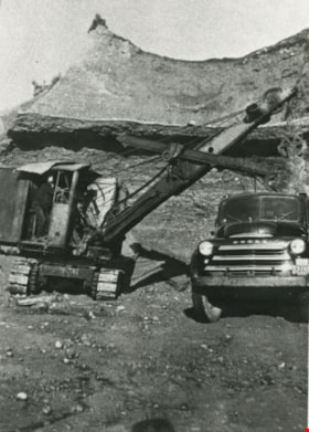
J. Engelland Fuels truck
https://search.heritageburnaby.ca/link/archivedescription35759
- Repository
- City of Burnaby Archives
- Date
- 1950 (date of original), copied 1986
- Collection/Fonds
- Burnaby Historical Society fonds
- Description Level
- Item
- Physical Description
- 1 photograph : b&w ; 12.7 x 17.8 cm print
- Scope and Content
- Photograph of a J. Engelland Fuels truck loading gravel at Stride pit. John Engelland began hauling gravel when the fuel business declined as people began using oil and electricity over wood, coal and sawdust.
- Repository
- City of Burnaby Archives
- Date
- 1950 (date of original), copied 1986
- Collection/Fonds
- Burnaby Historical Society fonds
- Subseries
- Pioneer Tales subseries
- Physical Description
- 1 photograph : b&w ; 12.7 x 17.8 cm print
- Description Level
- Item
- Record No.
- 204-617
- Access Restriction
- No restrictions
- Reproduction Restriction
- Reproduce for fair dealing purposes only
- Accession Number
- BHS1988-03
- Scope and Content
- Photograph of a J. Engelland Fuels truck loading gravel at Stride pit. John Engelland began hauling gravel when the fuel business declined as people began using oil and electricity over wood, coal and sawdust.
- Names
- J. Engelland Fuels
- Media Type
- Photograph
- Notes
- Title based on contents of photograph
- Planning Study Area
- Stride Hill Area
Images

![Leeside Interurban station, [1921] (date of original), copied 1986 thumbnail](/media/hpo/_Data/_Archives_Images/_Unrestricted/204/204-544.jpg?width=280)
Leeside Interurban station
https://search.heritageburnaby.ca/link/archivedescription35686
- Repository
- City of Burnaby Archives
- Date
- [1921] (date of original), copied 1986
- Collection/Fonds
- Burnaby Historical Society fonds
- Description Level
- Item
- Physical Description
- 1 photograph : b&w ; 12.7 x 17.8 cm print
- Scope and Content
- Photograph of Leeside Interurban station on the Central Park line. Reuben Butcher (father of Violet Butcher Lynds) walked to here to catch the tram to work at B.C. Sugar in Vancouver. Lanterns used by passengers walking to and from the station during dark winter mornings and evenings were left und…
- Repository
- City of Burnaby Archives
- Date
- [1921] (date of original), copied 1986
- Collection/Fonds
- Burnaby Historical Society fonds
- Subseries
- Pioneer Tales subseries
- Physical Description
- 1 photograph : b&w ; 12.7 x 17.8 cm print
- Description Level
- Item
- Record No.
- 204-544
- Access Restriction
- No restrictions
- Reproduction Restriction
- No known restrictions
- Accession Number
- BHS1988-03
- Scope and Content
- Photograph of Leeside Interurban station on the Central Park line. Reuben Butcher (father of Violet Butcher Lynds) walked to here to catch the tram to work at B.C. Sugar in Vancouver. Lanterns used by passengers walking to and from the station during dark winter mornings and evenings were left under the wooden floor of the station.
- Media Type
- Photograph
- Notes
- Title based on contents of photograph
- Geographic Access
- Central Park Interurban line
- Historic Neighbourhood
- Edmonds (Historic Neighbourhood)
- Planning Study Area
- Stride Hill Area
Images
![Leeside Interurban station, [1921] (date of original), copied 1986 thumbnail](/media/hpo/_Data/_Archives_Images/_Unrestricted/204/204-544.jpg)
![Lyle and Evelyn Le Grove, [1949] (date of original), copied 1991 thumbnail](/media/hpo/_Data/_Archives_Images/_Unrestricted/370/370-668.jpg?width=280)
Lyle and Evelyn Le Grove
https://search.heritageburnaby.ca/link/archivedescription38081
- Repository
- City of Burnaby Archives
- Date
- [1949] (date of original), copied 1991
- Collection/Fonds
- Burnaby Historical Society fonds
- Description Level
- Item
- Physical Description
- 1 photograph : b&w ; 3.0 x 3.0 cm print on contact sheet 20.2 x 26.2 cm
- Scope and Content
- Photograph of husband and wife Lyle and Evelyn Le Grove standing in front of 1007 Gilley Avenue (later renumbered 8416 Gilley Avenue).
- Repository
- City of Burnaby Archives
- Date
- [1949] (date of original), copied 1991
- Collection/Fonds
- Burnaby Historical Society fonds
- Subseries
- Burnaby Image Bank subseries
- Physical Description
- 1 photograph : b&w ; 3.0 x 3.0 cm print on contact sheet 20.2 x 26.2 cm
- Description Level
- Item
- Record No.
- 370-668
- Access Restriction
- No restrictions
- Reproduction Restriction
- No restrictions
- Accession Number
- BHS1999-03
- Scope and Content
- Photograph of husband and wife Lyle and Evelyn Le Grove standing in front of 1007 Gilley Avenue (later renumbered 8416 Gilley Avenue).
- Media Type
- Photograph
- Notes
- Title based on contents of photograph
- 1 b&w copy negative accompanying
- Negative has a pink cast
- Geographic Access
- Gilley Avenue
- Street Address
- 8416 Gilley Avenue
- Planning Study Area
- Stride Hill Area
Images
![Lyle and Evelyn Le Grove, [1949] (date of original), copied 1991 thumbnail](/media/hpo/_Data/_Archives_Images/_Unrestricted/370/370-668.jpg)
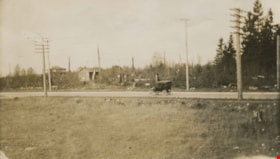
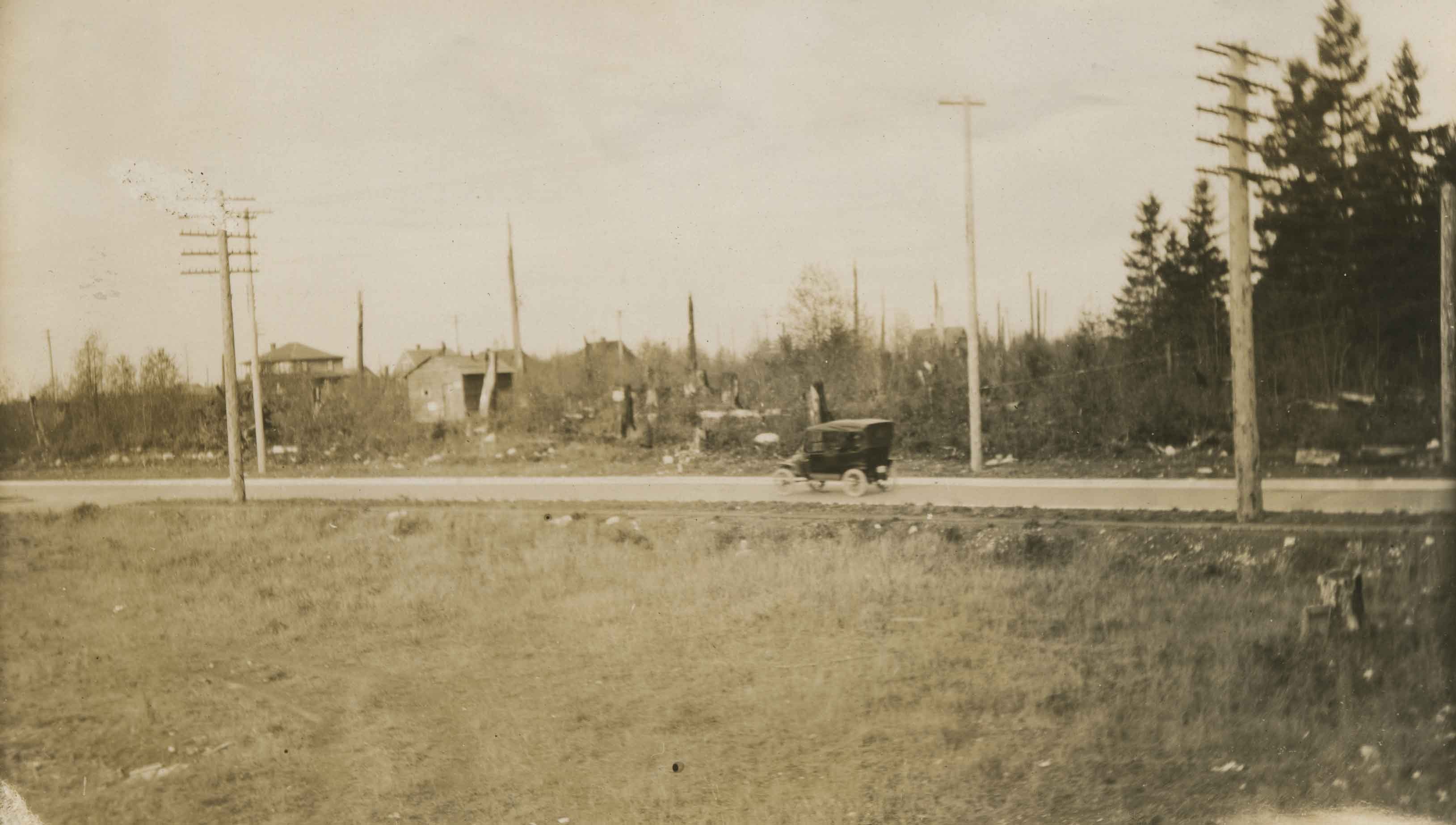
Middlegate
https://search.heritageburnaby.ca/link/archivedescription36164
- Repository
- City of Burnaby Archives
- Date
- 1912
- Collection/Fonds
- Burnaby Historical Society fonds
- Description Level
- Item
- Physical Description
- 1 photograph : sepia ; 8 x 14 cm
- Scope and Content
- Photograph of a touring car driving along Kingsway between the Edmonds junction and Royal Oak Avenue, in the area known as Middlegate.
- Repository
- City of Burnaby Archives
- Date
- 1912
- Collection/Fonds
- Burnaby Historical Society fonds
- Physical Description
- 1 photograph : sepia ; 8 x 14 cm
- Description Level
- Item
- Record No.
- 230-009
- Access Restriction
- No restrictions
- Reproduction Restriction
- No known restrictions
- Accession Number
- BHS1989-22
- Scope and Content
- Photograph of a touring car driving along Kingsway between the Edmonds junction and Royal Oak Avenue, in the area known as Middlegate.
- Subjects
- Geographic Features - Roads
- Media Type
- Photograph
- Notes
- Title based on contents of photograph
- Geographic Access
- Kingsway
- Historic Neighbourhood
- Edmonds (Historic Neighbourhood)
- Planning Study Area
- Stride Avenue Area
- Stride Hill Area
Images