Narrow Results By
Subject
- Advertising Medium 1
- Advertising Medium - Signs and Signboards 3
- Aerial Photographs 5
- Buildings - Civic - City Halls 1
- Buildings - Civic - Libraries 3
- Buildings - Commercial - Automobile Dealerships 1
- Buildings - Commercial - Grocery Stores 1
- Buildings - Commercial - Hotels and Motels 1
- Buildings - Commercial - Service Stations 1
- Buildings - Industrial - Dairies 1
- Buildings - Religious - Churches 1
- Buildings - Residential - Apartments 1
Aerial photograph of Burnaby
https://search.heritageburnaby.ca/link/archivedescription84919
- Repository
- City of Burnaby Archives
- Date
- 1963
- Collection/Fonds
- Allan Amundsen collection
- Description Level
- Item
- Physical Description
- 1 photograph : b&w ; 22.5 x 22.5 cm
- Scope and Content
- Aerial photograph of Burnaby in the area of Edmonds Street and Kingsway.
- Repository
- City of Burnaby Archives
- Date
- 1963
- Collection/Fonds
- Allan Amundsen collection
- Physical Description
- 1 photograph : b&w ; 22.5 x 22.5 cm
- Description Level
- Item
- Record No.
- 561-037
- Access Restriction
- In Archives only
- Reproduction Restriction
- No reproduction permitted
- Accession Number
- 2014-08
- Scope and Content
- Aerial photograph of Burnaby in the area of Edmonds Street and Kingsway.
- Subjects
- Aerial Photographs
- Media Type
- Photograph
- Photographer
- Province of British Columbia
- Notes
- Title based on contents of photograph
- This photo is indentified as BC5062:243 and connects with B.C. air photograph BC5062:242 to the east
- Historic Neighbourhood
- Edmonds (Historic Neighbourhood)
- Planning Study Area
- Stride Avenue Area
- Edmonds Area
- Richmond Park Area
- Lakeview-Mayfield Area
- Second Street Area
Aerial photograph of Burnaby
https://search.heritageburnaby.ca/link/archivedescription84920
- Repository
- City of Burnaby Archives
- Date
- 1963
- Collection/Fonds
- Allan Amundsen collection
- Description Level
- Item
- Physical Description
- 1 photograph : b&w ; 22.5 x 22.5 cm
- Scope and Content
- Aerial photograph of Burnaby in the area north east of Kingsway.
- Repository
- City of Burnaby Archives
- Date
- 1963
- Collection/Fonds
- Allan Amundsen collection
- Physical Description
- 1 photograph : b&w ; 22.5 x 22.5 cm
- Description Level
- Item
- Record No.
- 561-038
- Access Restriction
- In Archives only
- Reproduction Restriction
- No reproduction permitted
- Accession Number
- 2014-08
- Scope and Content
- Aerial photograph of Burnaby in the area north east of Kingsway.
- Subjects
- Aerial Photographs
- Media Type
- Photograph
- Photographer
- Province of British Columbia
- Notes
- Title based on contents of photograph
- This photo is indentified as BC5062:242 and connects with B.C. air photograph BC5062:243 to the west
- Historic Neighbourhood
- Edmonds (Historic Neighbourhood)
- Planning Study Area
- Stride Avenue Area
- Edmonds Area
- Lakeview-Mayfield Area
- Second Street Area

BC Hydro Railway Crossing
https://search.heritageburnaby.ca/link/archivedescription79487
- Repository
- City of Burnaby Archives
- Date
- September 22, 1976
- Collection/Fonds
- Burnaby Public Library Contemporary Visual Archive Project
- Description Level
- Item
- Physical Description
- 1 photograph : b&w ; 11 x 16 cm mounted on cardboard
- Scope and Content
- Photograph shows BC Hydro railroad tracks and crossing near Beresford Street and Griffiths Avenue.
- Repository
- City of Burnaby Archives
- Date
- September 22, 1976
- Collection/Fonds
- Burnaby Public Library Contemporary Visual Archive Project
- Physical Description
- 1 photograph : b&w ; 11 x 16 cm mounted on cardboard
- Description Level
- Item
- Record No.
- 556-319
- Access Restriction
- No restrictions
- Reproduction Restriction
- Reproduce for fair dealing purposes only
- Accession Number
- 2013-13
- Scope and Content
- Photograph shows BC Hydro railroad tracks and crossing near Beresford Street and Griffiths Avenue.
- Media Type
- Photograph
- Photographer
- Ross, Martha
- Notes
- Scope note taken directly from BPL photograph description.
- 1 b&w copy negative : 10 x 12.5 cm accompanying
- Historic Neighbourhood
- Edmonds (Historic Neighbourhood)
- Planning Study Area
- Stride Avenue Area
Images

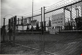
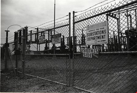
BC Hydro Substation
https://search.heritageburnaby.ca/link/archivedescription79356
- Repository
- City of Burnaby Archives
- Date
- September 22, 1976
- Collection/Fonds
- Burnaby Public Library Contemporary Visual Archive Project
- Description Level
- Item
- Physical Description
- 1 photograph : b&w ; 11 x 16 cm mounted on cardboard
- Scope and Content
- Photograph shows a BC Hydro substation located in Powerhouse Park near Beresford Street and Griffiths Avenue.
- Repository
- City of Burnaby Archives
- Date
- September 22, 1976
- Collection/Fonds
- Burnaby Public Library Contemporary Visual Archive Project
- Physical Description
- 1 photograph : b&w ; 11 x 16 cm mounted on cardboard
- Description Level
- Item
- Record No.
- 556-263
- Access Restriction
- No restrictions
- Reproduction Restriction
- Reproduce for fair dealing purposes only
- Accession Number
- 2013-13
- Scope and Content
- Photograph shows a BC Hydro substation located in Powerhouse Park near Beresford Street and Griffiths Avenue.
- Media Type
- Photograph
- Photographer
- Ross, Martha
- Notes
- Scope note taken directly from BPL photograph description.
- 1 b&w copy negative : 10 x 12.5 cm accompanying
- Geographic Access
- Griffiths Avenue
- Beresford Street
- Street Address
- 6970 Beresford Street
- Historic Neighbourhood
- Edmonds (Historic Neighbourhood)
- Planning Study Area
- Stride Avenue Area
Images
![Burnaby Police Office, [196-?] (date of original), copied 1992 thumbnail](/media/hpo/_Data/_Archives_Images/_Unrestricted/315/315-510.jpg?width=280)
Burnaby Police Office
https://search.heritageburnaby.ca/link/archivedescription37047
- Repository
- City of Burnaby Archives
- Date
- [196-?] (date of original), copied 1992
- Collection/Fonds
- Burnaby Historical Society fonds
- Description Level
- Item
- Physical Description
- 1 photograph : b&w ; 8.8 x 11.7 cm print
- Scope and Content
- Photograph of the exterior of the police office in the Municipal Hall at Edmonds Street and Kingsway.
- Repository
- City of Burnaby Archives
- Date
- [196-?] (date of original), copied 1992
- Collection/Fonds
- Burnaby Historical Society fonds
- Subseries
- Burnaby Centennial Anthology subseries
- Physical Description
- 1 photograph : b&w ; 8.8 x 11.7 cm print
- Description Level
- Item
- Record No.
- 315-510
- Access Restriction
- No restrictions
- Reproduction Restriction
- Reproduce for fair dealing purposes only
- Accession Number
- BHS1994-04
- Scope and Content
- Photograph of the exterior of the police office in the Municipal Hall at Edmonds Street and Kingsway.
- Names
- Burnaby City Hall
- Media Type
- Photograph
- Notes
- Title based on contents of photograph
- Geographic Access
- Kingsway
- Edmonds Street
- Historic Neighbourhood
- Edmonds (Historic Neighbourhood)
- Planning Study Area
- Stride Avenue Area
Images
![Burnaby Police Office, [196-?] (date of original), copied 1992 thumbnail](/media/hpo/_Data/_Archives_Images/_Unrestricted/315/315-510.jpg)

Buses parked near Kingsway
https://search.heritageburnaby.ca/link/archivedescription79484
- Repository
- City of Burnaby Archives
- Date
- October 7, 1976
- Collection/Fonds
- Burnaby Public Library Contemporary Visual Archive Project
- Description Level
- Item
- Physical Description
- 1 photograph : b&w ; 11 x 16 cm mounted on cardboard
- Scope and Content
- Photograph shows buses parked beneath gasoline billboard just off Kingsway near 13th Avenue.
- Repository
- City of Burnaby Archives
- Date
- October 7, 1976
- Collection/Fonds
- Burnaby Public Library Contemporary Visual Archive Project
- Physical Description
- 1 photograph : b&w ; 11 x 16 cm mounted on cardboard
- Description Level
- Item
- Record No.
- 556-316
- Access Restriction
- No restrictions
- Reproduction Restriction
- Reproduce for fair dealing purposes only
- Accession Number
- 2013-13
- Scope and Content
- Photograph shows buses parked beneath gasoline billboard just off Kingsway near 13th Avenue.
- Media Type
- Photograph
- Photographer
- Born, A. J.
- Notes
- Scope note taken directly from BPL photograph description.
- 1 b&w copy negative : 10 x 12.5 cm accompanying
- Geographic Access
- Kingsway
- 13th Avenue
- Historic Neighbourhood
- Edmonds (Historic Neighbourhood)
- Planning Study Area
- Stride Avenue Area
Images

Bus Stop on Kingsway
https://search.heritageburnaby.ca/link/archivedescription79480
- Repository
- City of Burnaby Archives
- Date
- September, 1976
- Collection/Fonds
- Burnaby Public Library Contemporary Visual Archive Project
- Description Level
- Item
- Physical Description
- 1 photograph : b&w ; 11 x 16 cm mounted on cardboard
- Scope and Content
- Photograph shows people waiting for a bus at a stop on Kingsway near Walker Avenue.
- Repository
- City of Burnaby Archives
- Date
- September, 1976
- Collection/Fonds
- Burnaby Public Library Contemporary Visual Archive Project
- Physical Description
- 1 photograph : b&w ; 11 x 16 cm mounted on cardboard
- Description Level
- Item
- Record No.
- 556-312
- Access Restriction
- No restrictions
- Reproduction Restriction
- Reproduce for fair dealing purposes only
- Accession Number
- 2013-13
- Scope and Content
- Photograph shows people waiting for a bus at a stop on Kingsway near Walker Avenue.
- Subjects
- Transportation - Buses
- Media Type
- Photograph
- Photographer
- Ross, Martha
- Notes
- Scope note taken directly from BPL photograph description.
- 1 b&w copy negative : 10 x 12.5 cm accompanying
- Geographic Access
- Kingsway
- Walker Avenue
- Historic Neighbourhood
- Edmonds (Historic Neighbourhood)
- Planning Study Area
- Stride Avenue Area
Images

![Car in front of Loynes Family Home, [ca. 1973] (date of original), copied 1991 thumbnail](/media/hpo/_Data/_Archives_Images/_Unrestricted/370/370-260.jpg?width=280)
Car in front of Loynes Family Home
https://search.heritageburnaby.ca/link/archivedescription37672
- Repository
- City of Burnaby Archives
- Date
- [ca. 1973] (date of original), copied 1991
- Collection/Fonds
- Burnaby Historical Society fonds
- Description Level
- Item
- Physical Description
- 1 photograph : b&w ; 3.9 x 3.9 cm print on contact sheet 20.2 x 25.3 cm
- Scope and Content
- Photograph of the Loynes family home at 1855 18th Avenue (later renumbered as the 7000 block of 18th Avenue), with a car parked in front. The photo was taken from across the street.
- Repository
- City of Burnaby Archives
- Date
- [ca. 1973] (date of original), copied 1991
- Collection/Fonds
- Burnaby Historical Society fonds
- Subseries
- Burnaby Image Bank subseries
- Physical Description
- 1 photograph : b&w ; 3.9 x 3.9 cm print on contact sheet 20.2 x 25.3 cm
- Description Level
- Item
- Record No.
- 370-260
- Access Restriction
- No restrictions
- Reproduction Restriction
- No restrictions
- Accession Number
- BHS1999-03
- Scope and Content
- Photograph of the Loynes family home at 1855 18th Avenue (later renumbered as the 7000 block of 18th Avenue), with a car parked in front. The photo was taken from across the street.
- Media Type
- Photograph
- Notes
- Title based on contents of photograph
- 1 b&w copy negative accompanying
- Copied from col. photograph
- Negative has a pink cast
- Geographic Access
- 18th Avenue
- Historic Neighbourhood
- Edmonds (Historic Neighbourhood)
- Planning Study Area
- Stride Avenue Area
Images
![Car in front of Loynes Family Home, [ca. 1973] (date of original), copied 1991 thumbnail](/media/hpo/_Data/_Archives_Images/_Unrestricted/370/370-260.jpg)

Construction on Acorn Avenue
https://search.heritageburnaby.ca/link/archivedescription79040
- Repository
- City of Burnaby Archives
- Date
- October 20, 1976
- Collection/Fonds
- Burnaby Public Library Contemporary Visual Archive Project
- Description Level
- Item
- Physical Description
- 1 photograph : b&w ; 11 x 16 cm mounted on cardboard
- Scope and Content
- Photograph shows a view from Hall Towers of houses and a high-rise under construction on Acorn Avenue.
- Repository
- City of Burnaby Archives
- Date
- October 20, 1976
- Collection/Fonds
- Burnaby Public Library Contemporary Visual Archive Project
- Physical Description
- 1 photograph : b&w ; 11 x 16 cm mounted on cardboard
- Description Level
- Item
- Record No.
- 556-108
- Access Restriction
- No restrictions
- Reproduction Restriction
- Reproduce for fair dealing purposes only
- Accession Number
- 2013-13
- Scope and Content
- Photograph shows a view from Hall Towers of houses and a high-rise under construction on Acorn Avenue.
- Media Type
- Photograph
- Photographer
- Ross, Martha
- Notes
- Scope note taken directly from BPL photograph description.
- 1 b&w copy negative : 10 x 12.5 cm accompanying
- Geographic Access
- Acorn Avenue
- Historic Neighbourhood
- Edmonds (Historic Neighbourhood)
- Planning Study Area
- Stride Avenue Area
Images

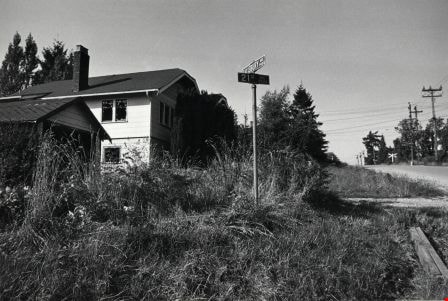
Corner of Salisbury Avenue and 21st Avenue
https://search.heritageburnaby.ca/link/archivedescription78866
- Repository
- City of Burnaby Archives
- Date
- September 23, 1976
- Collection/Fonds
- Burnaby Public Library Contemporary Visual Archive Project
- Description Level
- Item
- Physical Description
- 1 photograph : b&w ; 11 x 16 cm mounted on cardboard
- Scope and Content
- Photograph shows an abandoned house and garage at the corner of Salisbury Avenue and 21st Avenue. The house and garage have been completely demolished since the picture was taken.
- Repository
- City of Burnaby Archives
- Date
- September 23, 1976
- Collection/Fonds
- Burnaby Public Library Contemporary Visual Archive Project
- Physical Description
- 1 photograph : b&w ; 11 x 16 cm mounted on cardboard
- Description Level
- Item
- Record No.
- 556-010
- Access Restriction
- No restrictions
- Reproduction Restriction
- Reproduce for fair dealing purposes only
- Accession Number
- 2013-13
- Scope and Content
- Photograph shows an abandoned house and garage at the corner of Salisbury Avenue and 21st Avenue. The house and garage have been completely demolished since the picture was taken.
- Media Type
- Photograph
- Photographer
- Ross, Martha
- Notes
- Scope note taken directly from BPL photograph description.
- 1 b&w copy negative : 10 x 12.5 cm accompanying
- Geographic Access
- Salisbury Avenue
- 21st Avenue
- Historic Neighbourhood
- Edmonds (Historic Neighbourhood)
- Planning Study Area
- Stride Avenue Area
Images
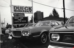
Dueck Middlegate
https://search.heritageburnaby.ca/link/archivedescription79254
- Repository
- City of Burnaby Archives
- Date
- September 22, 1976
- Collection/Fonds
- Burnaby Public Library Contemporary Visual Archive Project
- Description Level
- Item
- Physical Description
- 1 photograph : b&w ; 11 x 16 cm mounted on cardboard
- Scope and Content
- Photograph shows cars in the lot of Dueck Middlegate at 7112 Kingsway.
- Repository
- City of Burnaby Archives
- Date
- September 22, 1976
- Collection/Fonds
- Burnaby Public Library Contemporary Visual Archive Project
- Physical Description
- 1 photograph : b&w ; 11 x 16 cm mounted on cardboard
- Description Level
- Item
- Record No.
- 556-223
- Access Restriction
- No restrictions
- Reproduction Restriction
- Reproduce for fair dealing purposes only
- Accession Number
- 2013-13
- Scope and Content
- Photograph shows cars in the lot of Dueck Middlegate at 7112 Kingsway.
- Names
- Dueck Middlegate
- Media Type
- Photograph
- Photographer
- Ross, Martha
- Notes
- Scope note taken directly from BPL photograph description.
- 1 b&w copy negative : 10 x 12.5 cm accompanying
- Geographic Access
- Kingsway
- Street Address
- 7112 Kingsway
- Historic Neighbourhood
- Edmonds (Historic Neighbourhood)
- Planning Study Area
- Stride Avenue Area
Images

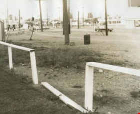
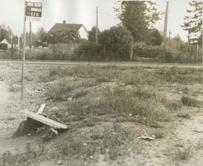
Edmonds Bus Loop
https://search.heritageburnaby.ca/link/archivedescription34597
- Repository
- City of Burnaby Archives
- Date
- July 15, 1966
- Collection/Fonds
- Burnaby Historical Society fonds
- Description Level
- Item
- Physical Description
- 1 photograph : b&w negative ; 4.7 x 4.6 cm
- Scope and Content
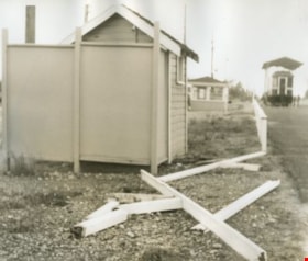
- Photograph of the Edmonds Bus Loop at Edmonds Street and Kingsway with a broken fence in the foreground. No buses are visible.
- Repository
- City of Burnaby Archives
- Date
- July 15, 1966
- Collection/Fonds
- Burnaby Historical Society fonds
- Subseries
- Photographs subseries
- Physical Description
- 1 photograph : b&w negative ; 4.7 x 4.6 cm
- Description Level
- Item
- Record No.
- 066-001
- Access Restriction
- No restrictions
- Reproduction Restriction
- Reproduce for fair dealing purposes only
- Accession Number
- BHS2007-04
- Scope and Content
- Photograph of the Edmonds Bus Loop at Edmonds Street and Kingsway with a broken fence in the foreground. No buses are visible.
- Subjects
- Transportation - Public Transit
- Media Type
- Photograph
- Notes
- Title based on contents of photograph
- 1 b&w photograph accompanying
- Geographic Access
- Kingsway
- Edmonds Street
- Historic Neighbourhood
- Edmonds (Historic Neighbourhood)
- Planning Study Area
- Stride Avenue Area
Images


Edmonds Bus Loop
https://search.heritageburnaby.ca/link/archivedescription34598
- Repository
- City of Burnaby Archives
- Date
- July 15, 1966
- Collection/Fonds
- Burnaby Historical Society fonds
- Description Level
- Item
- Physical Description
- 1 photograph : b&w negative ; 4.4 x 4.5 cm
- Scope and Content
- Photograph of the Edmonds Bus Loop at Edmonds Street and Kingsway. There is a bus stop sign for the 31 Douglas and 58 SFU with "For bus information phone 261-4211" written at the bottom. No buses are visible.
- Repository
- City of Burnaby Archives
- Date
- July 15, 1966
- Collection/Fonds
- Burnaby Historical Society fonds
- Subseries
- Photographs subseries
- Physical Description
- 1 photograph : b&w negative ; 4.4 x 4.5 cm
- Description Level
- Item
- Record No.
- 066-002
- Access Restriction
- No restrictions
- Reproduction Restriction
- Reproduce for fair dealing purposes only
- Accession Number
- BHS2007-04
- Scope and Content
- Photograph of the Edmonds Bus Loop at Edmonds Street and Kingsway. There is a bus stop sign for the 31 Douglas and 58 SFU with "For bus information phone 261-4211" written at the bottom. No buses are visible.
- Subjects
- Transportation - Public Transit
- Media Type
- Photograph
- Notes
- Title based on contents of photograph
- 1 b&w photograph accompanying
- Geographic Access
- Kingsway
- Edmonds Street
- Historic Neighbourhood
- Edmonds (Historic Neighbourhood)
- Planning Study Area
- Stride Avenue Area
Images
Edmonds Bus Loop
https://search.heritageburnaby.ca/link/archivedescription34600
- Repository
- City of Burnaby Archives
- Date
- July 15, 1966
- Collection/Fonds
- Burnaby Historical Society fonds
- Description Level
- Item
- Physical Description
- 1 photograph : b&w negative ; 4.5 x 4.6 cm
- Scope and Content
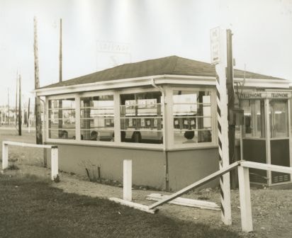
- Photograph of the Edmonds Bus Loop at Edmonds Street and Kingsway including two buses, a bus shelter, and a telephone booth. Stores and billboards, including one for "Mounties play-by-play" on CKWX, can be seen in the background.
- Repository
- City of Burnaby Archives
- Date
- July 15, 1966
- Collection/Fonds
- Burnaby Historical Society fonds
- Subseries
- Photographs subseries
- Physical Description
- 1 photograph : b&w negative ; 4.5 x 4.6 cm
- Description Level
- Item
- Record No.
- 066-004
- Access Restriction
- No restrictions
- Reproduction Restriction
- Reproduce for fair dealing purposes only
- Accession Number
- BHS2007-04
- Scope and Content
- Photograph of the Edmonds Bus Loop at Edmonds Street and Kingsway including two buses, a bus shelter, and a telephone booth. Stores and billboards, including one for "Mounties play-by-play" on CKWX, can be seen in the background.
- Subjects
- Transportation - Public Transit
- Media Type
- Photograph
- Notes
- Title based on contents of photograph
- 1 b&w photograph accompanying
- Geographic Access
- Kingsway
- Edmonds Street
- Historic Neighbourhood
- Edmonds (Historic Neighbourhood)
- Planning Study Area
- Stride Avenue Area
Images

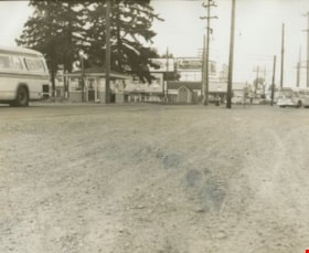
Edmonds Bus Loop
https://search.heritageburnaby.ca/link/archivedescription34601
- Repository
- City of Burnaby Archives
- Date
- July 15, 1966
- Collection/Fonds
- Burnaby Historical Society fonds
- Description Level
- Item
- Physical Description
- 1 photograph : b&w negative ; 4.6 x 4.6 cm
- Scope and Content
- Photograph of the Edmonds Bus Loop at Edmonds Street and Kingsway, including a broken fence. Interurban tram no. 1223 is visible in the upper right of the photograph.
- Repository
- City of Burnaby Archives
- Date
- July 15, 1966
- Collection/Fonds
- Burnaby Historical Society fonds
- Subseries
- Photographs subseries
- Physical Description
- 1 photograph : b&w negative ; 4.6 x 4.6 cm
- Description Level
- Item
- Record No.
- 066-005
- Access Restriction
- No restrictions
- Reproduction Restriction
- Reproduce for fair dealing purposes only
- Accession Number
- BHS2007-04
- Scope and Content
- Photograph of the Edmonds Bus Loop at Edmonds Street and Kingsway, including a broken fence. Interurban tram no. 1223 is visible in the upper right of the photograph.
- Subjects
- Transportation - Public Transit
- Media Type
- Photograph
- Notes
- Title based on contents of photograph
- 1 b&w photograph accompanying
- Geographic Access
- Kingsway
- Edmonds Street
- Historic Neighbourhood
- Edmonds (Historic Neighbourhood)
- Planning Study Area
- Stride Avenue Area
Images


Edmonds Bus Loop
https://search.heritageburnaby.ca/link/archivedescription34602
- Repository
- City of Burnaby Archives
- Date
- July 15, 1966
- Collection/Fonds
- Burnaby Historical Society fonds
- Description Level
- Item
- Physical Description
- 1 photograph : b&w negative ; 4.4 x 4.6 cm
- Scope and Content
- Photograph of the Edmonds Bus Loop at Edmonds Street and Kingsway, including a bus shelter and telephone booth with a broken fence in front. A Safeway sign can be seen in the background.
- Repository
- City of Burnaby Archives
- Date
- July 15, 1966
- Collection/Fonds
- Burnaby Historical Society fonds
- Subseries
- Photographs subseries
- Physical Description
- 1 photograph : b&w negative ; 4.4 x 4.6 cm
- Description Level
- Item
- Record No.
- 066-006
- Access Restriction
- No restrictions
- Reproduction Restriction
- Reproduce for fair dealing purposes only
- Accession Number
- BHS2007-04
- Scope and Content
- Photograph of the Edmonds Bus Loop at Edmonds Street and Kingsway, including a bus shelter and telephone booth with a broken fence in front. A Safeway sign can be seen in the background.
- Subjects
- Transportation - Public Transit
- Media Type
- Photograph
- Notes
- Title based on contents of photograph
- 1 b&w photograph accompanying
- Geographic Access
- Kingsway
- Edmonds Street
- Historic Neighbourhood
- Edmonds (Historic Neighbourhood)
- Planning Study Area
- Stride Avenue Area
Images

Edmonds Bus Loop
https://search.heritageburnaby.ca/link/archivedescription34603
- Repository
- City of Burnaby Archives
- Date
- July 15, 1966
- Collection/Fonds
- Burnaby Historical Society fonds
- Description Level
- Item
- Physical Description
- 1 photograph : b&w negative ; 4.7 x 4.6 cm
- Scope and Content
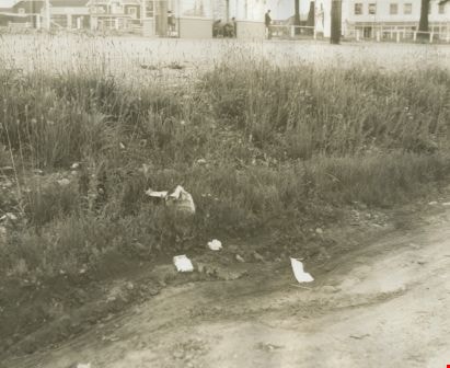
- Photograph of the Edmonds Bus Loop with brush and garbage at the side of the road. A bus shelter can be seen in the background.
- Repository
- City of Burnaby Archives
- Date
- July 15, 1966
- Collection/Fonds
- Burnaby Historical Society fonds
- Subseries
- Photographs subseries
- Physical Description
- 1 photograph : b&w negative ; 4.7 x 4.6 cm
- Description Level
- Item
- Record No.
- 066-007
- Access Restriction
- No restrictions
- Reproduction Restriction
- Reproduce for fair dealing purposes only
- Accession Number
- BHS2007-04
- Scope and Content
- Photograph of the Edmonds Bus Loop with brush and garbage at the side of the road. A bus shelter can be seen in the background.
- Subjects
- Transportation - Public Transit
- Media Type
- Photograph
- Notes
- Title based on contents of photograph
- 1 b&w photograph accompanying
- Geographic Access
- Kingsway
- Edmonds Street
- Historic Neighbourhood
- Edmonds (Historic Neighbourhood)
- Planning Study Area
- Stride Avenue Area
Images
![From 1855 18th Avenue, [1972 or 1973] (date of original), copied 1991 thumbnail](/media/hpo/_Data/_Archives_Images/_Unrestricted/370/370-262.jpg?width=280)
From 1855 18th Avenue
https://search.heritageburnaby.ca/link/archivedescription37674
- Repository
- City of Burnaby Archives
- Date
- [1972 or 1973] (date of original), copied 1991
- Collection/Fonds
- Burnaby Historical Society fonds
- Description Level
- Item
- Physical Description
- 1 photograph : b&w ; 3.8 x 3.8 cm print on contact sheet 20.2 x 25.3 cm
- Scope and Content
- Photograph taken from the back porch of 1855 18th Avenue (later renumbered as the 7000 block of 18th Avenue) looking west. Houses and mountains are visible.
- Repository
- City of Burnaby Archives
- Date
- [1972 or 1973] (date of original), copied 1991
- Collection/Fonds
- Burnaby Historical Society fonds
- Subseries
- Burnaby Image Bank subseries
- Physical Description
- 1 photograph : b&w ; 3.8 x 3.8 cm print on contact sheet 20.2 x 25.3 cm
- Description Level
- Item
- Record No.
- 370-262
- Access Restriction
- No restrictions
- Reproduction Restriction
- No restrictions
- Accession Number
- BHS1999-03
- Scope and Content
- Photograph taken from the back porch of 1855 18th Avenue (later renumbered as the 7000 block of 18th Avenue) looking west. Houses and mountains are visible.
- Media Type
- Photograph
- Notes
- Title based on contents of photograph
- 1 b&w copy negative accompanying
- Negative has a pink cast
- Copied from col. photograph
- Geographic Access
- 18th Avenue
- Historic Neighbourhood
- Edmonds (Historic Neighbourhood)
- Planning Study Area
- Stride Avenue Area
Images
![From 1855 18th Avenue, [1972 or 1973] (date of original), copied 1991 thumbnail](/media/hpo/_Data/_Archives_Images/_Unrestricted/370/370-262.jpg)
![From 1855 18th Avenue, [1972 or 1973] (date of original), copied 1991 thumbnail](/media/hpo/_Data/_Archives_Images/_Unrestricted/370/370-263.jpg?width=280)
From 1855 18th Avenue
https://search.heritageburnaby.ca/link/archivedescription37675
- Repository
- City of Burnaby Archives
- Date
- [1972 or 1973] (date of original), copied 1991
- Collection/Fonds
- Burnaby Historical Society fonds
- Description Level
- Item
- Physical Description
- 1 photograph : b&w ; 3.9 x 3.9 cm print on contact sheet 20.2 x 25.3 cm
- Scope and Content
- Photograph taken from the front of 1855 18th Avenue (later renumbered as the 7000 block of 18th Avenue), looking north down the street in the snow.
- Repository
- City of Burnaby Archives
- Date
- [1972 or 1973] (date of original), copied 1991
- Collection/Fonds
- Burnaby Historical Society fonds
- Subseries
- Burnaby Image Bank subseries
- Physical Description
- 1 photograph : b&w ; 3.9 x 3.9 cm print on contact sheet 20.2 x 25.3 cm
- Description Level
- Item
- Record No.
- 370-263
- Access Restriction
- No restrictions
- Reproduction Restriction
- No restrictions
- Accession Number
- BHS1999-03
- Scope and Content
- Photograph taken from the front of 1855 18th Avenue (later renumbered as the 7000 block of 18th Avenue), looking north down the street in the snow.
- Media Type
- Photograph
- Notes
- Title based on contents of photograph
- 1 b&w copy negative accompanying
- Negative has a pink cast
- Copied from col. photograph
- Geographic Access
- 18th Avenue
- Historic Neighbourhood
- Edmonds (Historic Neighbourhood)
- Planning Study Area
- Stride Avenue Area
Images
![From 1855 18th Avenue, [1972 or 1973] (date of original), copied 1991 thumbnail](/media/hpo/_Data/_Archives_Images/_Unrestricted/370/370-263.jpg)

Galaxie Collision Ltd.
https://search.heritageburnaby.ca/link/archivedescription79255
- Repository
- City of Burnaby Archives
- Date
- September 24, 1976
- Collection/Fonds
- Burnaby Public Library Contemporary Visual Archive Project
- Description Level
- Item
- Physical Description
- 1 photograph : b&w ; 11 x 16 cm mounted on cardboard
- Scope and Content
- Photograph shows a sign attached to an old automobile advertising Galaxie Collision Ltd. The car and sign are parked in a lot on the corner of Kingsway and Griffiths Avenue directing people to the business one block south of Kingsway at 7498A Griffiths Avenue.
- Repository
- City of Burnaby Archives
- Date
- September 24, 1976
- Collection/Fonds
- Burnaby Public Library Contemporary Visual Archive Project
- Physical Description
- 1 photograph : b&w ; 11 x 16 cm mounted on cardboard
- Description Level
- Item
- Record No.
- 556-224
- Access Restriction
- No restrictions
- Reproduction Restriction
- Reproduce for fair dealing purposes only
- Accession Number
- 2013-13
- Scope and Content
- Photograph shows a sign attached to an old automobile advertising Galaxie Collision Ltd. The car and sign are parked in a lot on the corner of Kingsway and Griffiths Avenue directing people to the business one block south of Kingsway at 7498A Griffiths Avenue.
- Names
- Galaxie Collision Ltd.
- Media Type
- Photograph
- Photographer
- Born, A. J.
- Notes
- Scope note taken directly from BPL photograph description.
- 1 b&w copy negative : 10 x 12.5 cm accompanying
- Geographic Access
- Kingsway
- Griffiths Avenue
- Street Address
- 7498 Griffiths Avenue
- Historic Neighbourhood
- Edmonds (Historic Neighbourhood)
- Planning Study Area
- Stride Avenue Area
Images
