Narrow Results By
Subject
- Advertising Medium 1
- Aerial Photographs 2
- Buildings - Civic - City Halls 4
- Buildings - Civic - Libraries 2
- Buildings - Commercial - Hotels and Motels 1
- Buildings - Commercial - Train Stations 1
- Buildings - Industrial - Factories 1
- Buildings - Industrial - Powerhouses 4
- Buildings - Residential - Houses 1
- Carpentry 1
- Clothing - Uniforms 2
- Documentary Artifacts - Postcards 1

East Burnaby Neighbourhood
https://search.heritageburnaby.ca/link/landmark712
- Repository
- Burnaby Heritage Planning
- Associated Dates
- 1925-1954
- Heritage Value
- After a lull in construction during the World War I period, East Burnaby Neighbourhood's growth resumed during the 1920s when many homes and businesses were constructed. The post-World War Two period also saw rapid construction and the creation of new housing developments in response to a population boom. The neighbourhood remained a primarily single-family residential area.
- Historic Neighbourhood
- Edmonds (Historic Neighbourhood)
- Planning Study Area
- Stride Avenue Area
Images


Edmonds Neighbourhood
https://search.heritageburnaby.ca/link/landmark704
- Repository
- Burnaby Heritage Planning
- Associated Dates
- 1925-1954
- Heritage Value
- The historic growth of Edmonds as a neighbourhood was based on its strategic location on the early interurban line between Vancouver and New Westminster. Even by 1980 when a survey of the residential neighbourhoods was conducted, a full 25% of homes in the area predated 1930. The 1950s was a period of strong housing development, with both single-family and multi-family units being constructed. Although Burnaby's City Hall was moved from Kingsway and Edmonds in the early 1950s, Edmonds remained an important centre in the community.
- Historic Neighbourhood
- Edmonds (Historic Neighbourhood)
- Planning Study Area
- Stride Avenue Area
Images


Stride Avenue Neighbourhood
https://search.heritageburnaby.ca/link/landmark845
- Repository
- Burnaby Heritage Planning
- Associated Dates
- 1955-2008
- Heritage Value
- The interurban link between New Westminster and Vancouver stimulated the early settlement of Stride Avenue. Infilling of the area took place in the early 1950s and the pace of development had slowed considerably by 1970. Duplexes became a popular feature in the decade between 1970 and 1980 and in the late 1980s, the neighbourhood was incorporated into the Edmonds Town Centre South plan.
- Historic Neighbourhood
- Edmonds (Historic Neighbourhood)
- Planning Study Area
- Stride Avenue Area
Images

Aerial photograph of Burnaby
https://search.heritageburnaby.ca/link/archivedescription84919
- Repository
- City of Burnaby Archives
- Date
- 1963
- Collection/Fonds
- Allan Amundsen collection
- Description Level
- Item
- Physical Description
- 1 photograph : b&w ; 22.5 x 22.5 cm
- Scope and Content
- Aerial photograph of Burnaby in the area of Edmonds Street and Kingsway.
- Repository
- City of Burnaby Archives
- Date
- 1963
- Collection/Fonds
- Allan Amundsen collection
- Physical Description
- 1 photograph : b&w ; 22.5 x 22.5 cm
- Description Level
- Item
- Record No.
- 561-037
- Access Restriction
- In Archives only
- Reproduction Restriction
- No reproduction permitted
- Accession Number
- 2014-08
- Scope and Content
- Aerial photograph of Burnaby in the area of Edmonds Street and Kingsway.
- Subjects
- Aerial Photographs
- Media Type
- Photograph
- Photographer
- Province of British Columbia
- Notes
- Title based on contents of photograph
- This photo is indentified as BC5062:243 and connects with B.C. air photograph BC5062:242 to the east
- Historic Neighbourhood
- Edmonds (Historic Neighbourhood)
- Planning Study Area
- Stride Avenue Area
- Edmonds Area
- Richmond Park Area
- Lakeview-Mayfield Area
- Second Street Area
Aerial photograph of Burnaby
https://search.heritageburnaby.ca/link/archivedescription84920
- Repository
- City of Burnaby Archives
- Date
- 1963
- Collection/Fonds
- Allan Amundsen collection
- Description Level
- Item
- Physical Description
- 1 photograph : b&w ; 22.5 x 22.5 cm
- Scope and Content
- Aerial photograph of Burnaby in the area north east of Kingsway.
- Repository
- City of Burnaby Archives
- Date
- 1963
- Collection/Fonds
- Allan Amundsen collection
- Physical Description
- 1 photograph : b&w ; 22.5 x 22.5 cm
- Description Level
- Item
- Record No.
- 561-038
- Access Restriction
- In Archives only
- Reproduction Restriction
- No reproduction permitted
- Accession Number
- 2014-08
- Scope and Content
- Aerial photograph of Burnaby in the area north east of Kingsway.
- Subjects
- Aerial Photographs
- Media Type
- Photograph
- Photographer
- Province of British Columbia
- Notes
- Title based on contents of photograph
- This photo is indentified as BC5062:242 and connects with B.C. air photograph BC5062:243 to the west
- Historic Neighbourhood
- Edmonds (Historic Neighbourhood)
- Planning Study Area
- Stride Avenue Area
- Edmonds Area
- Lakeview-Mayfield Area
- Second Street Area
Basil Pontifex at No. 2 Firehall
https://search.heritageburnaby.ca/link/archivedescription37904
- Repository
- City of Burnaby Archives
- Date
- 1947 (date of original), copied 1991
- Collection/Fonds
- Burnaby Historical Society fonds
- Description Level
- Item
- Physical Description
- 1 photograph : b&w ; 3.7 x 2.3 cm print on contact sheet 20.2 x 26.3 cm
- Scope and Content
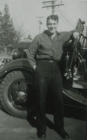
- Photograph of Basil Pontifex leaning on the front of a truck at the No. 2 Firehall at Kingsway and Hall Avenue. Basil was a Burnaby firefighter.
- Repository
- City of Burnaby Archives
- Date
- 1947 (date of original), copied 1991
- Collection/Fonds
- Burnaby Historical Society fonds
- Subseries
- Burnaby Image Bank subseries
- Physical Description
- 1 photograph : b&w ; 3.7 x 2.3 cm print on contact sheet 20.2 x 26.3 cm
- Description Level
- Item
- Record No.
- 370-492
- Access Restriction
- No restrictions
- Reproduction Restriction
- No known restrictions
- Accession Number
- BHS1999-03
- Scope and Content
- Photograph of Basil Pontifex leaning on the front of a truck at the No. 2 Firehall at Kingsway and Hall Avenue. Basil was a Burnaby firefighter.
- Names
- Pontifex, Basil
- Media Type
- Photograph
- Notes
- Title based on contents of photograph
- 1 b&w copy negative accompanying
- Negative has a pink cast
- Geographic Access
- Kingsway
- Hall Avenue
- Historic Neighbourhood
- Edmonds (Historic Neighbourhood)
- Planning Study Area
- Stride Avenue Area
Images
Bill Corbett
https://search.heritageburnaby.ca/link/archivedescription37923
- Repository
- City of Burnaby Archives
- Date
- 1947 (date of original), copied 1991
- Collection/Fonds
- Burnaby Historical Society fonds
- Description Level
- Item
- Physical Description
- 1 photograph : b&w ; 4.0 x 2.5 cm print on contact sheet 20.7 x 26.5 cm
- Scope and Content
- Photograph of firefighter Bill Corbett leaning against a truck at Fire Hall No. 2 located at 1942 Kingsway and Hall Avenue (later renumbered as the 7200 block of Kingsway). The door of the truck reads BFD No. 3.
- Repository
- City of Burnaby Archives
- Date
- 1947 (date of original), copied 1991
- Collection/Fonds
- Burnaby Historical Society fonds
- Subseries
- Burnaby Image Bank subseries
- Physical Description
- 1 photograph : b&w ; 4.0 x 2.5 cm print on contact sheet 20.7 x 26.5 cm
- Description Level
- Item
- Record No.
- 370-511
- Access Restriction
- No restrictions
- Reproduction Restriction
- No known restrictions
- Accession Number
- BHS1999-03
- Scope and Content
- Photograph of firefighter Bill Corbett leaning against a truck at Fire Hall No. 2 located at 1942 Kingsway and Hall Avenue (later renumbered as the 7200 block of Kingsway). The door of the truck reads BFD No. 3.
- Names
- Corbett, William "Bill"
- Media Type
- Photograph
- Notes
- Title based on contents of photograph
- 1 b&w copy negative accompanying
- Negative has a pink cast
- Geographic Access
- Kingsway
- Hall Avenue
- Historic Neighbourhood
- Edmonds (Historic Neighbourhood)
- Planning Study Area
- Stride Avenue Area
Images

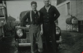
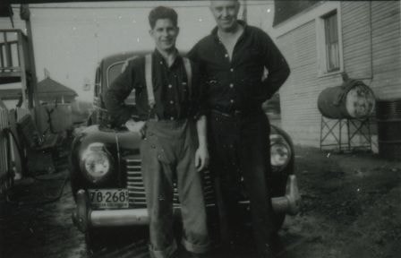
Bill Corbett and Sam Davies
https://search.heritageburnaby.ca/link/archivedescription37924
- Repository
- City of Burnaby Archives
- Date
- 1947 (date of original), copied 1991
- Collection/Fonds
- Burnaby Historical Society fonds
- Description Level
- Item
- Physical Description
- 1 photograph : b&w ; 2.7 x 4.3 cm print on contact sheet 20.7 x 26.5 cm
- Scope and Content
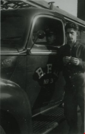
- Photograph of firefighters Bill Corbett and Sam Davies standing in front of a car at Fire Hall No. 2 located at 1942 Kingsway and Hall Avenue (later renumbered as the 7200 block of Kingsway).
- Repository
- City of Burnaby Archives
- Date
- 1947 (date of original), copied 1991
- Collection/Fonds
- Burnaby Historical Society fonds
- Subseries
- Burnaby Image Bank subseries
- Physical Description
- 1 photograph : b&w ; 2.7 x 4.3 cm print on contact sheet 20.7 x 26.5 cm
- Description Level
- Item
- Record No.
- 370-512
- Access Restriction
- No restrictions
- Reproduction Restriction
- No known restrictions
- Accession Number
- BHS1999-03
- Scope and Content
- Photograph of firefighters Bill Corbett and Sam Davies standing in front of a car at Fire Hall No. 2 located at 1942 Kingsway and Hall Avenue (later renumbered as the 7200 block of Kingsway).
- Subjects
- Occupations - Fire Fighters
- Media Type
- Photograph
- Notes
- Title based on contents of photograph
- 1 b&w copy negative accompanying
- Negative has a pink cast
- Geographic Access
- Kingsway
- Hall Avenue
- Historic Neighbourhood
- Edmonds (Historic Neighbourhood)
- Planning Study Area
- Stride Avenue Area
Images
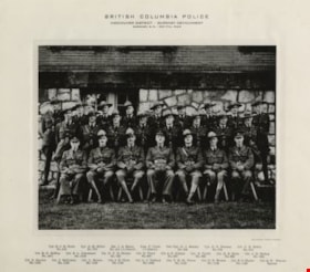
British Columbia Police
https://search.heritageburnaby.ca/link/archivedescription34562
- Repository
- City of Burnaby Archives
- Date
- May 7, 1949
- Collection/Fonds
- Burnaby Historical Society fonds
- Description Level
- Item
- Physical Description
- 1 photograph : b&w ; 19.2 x 24.6 cm mounted on 30.4 x 35.5 cm cardboard
- Scope and Content
- Photograph of the British Columbia Provincial Police, Burnaby Detachment at Burnaby Municipal Hall. The caption above the photograph reads, "British Columbia Police / Vancouver District - Burnaby Detachment / Burnaby, B.C. - May 7th, 1949. The members are, front row, left to right: Cpl. R.C.B Foo…
- Repository
- City of Burnaby Archives
- Date
- May 7, 1949
- Collection/Fonds
- Burnaby Historical Society fonds
- Subseries
- Photographs subseries
- Physical Description
- 1 photograph : b&w ; 19.2 x 24.6 cm mounted on 30.4 x 35.5 cm cardboard
- Description Level
- Item
- Record No.
- 049-001
- Access Restriction
- No restrictions
- Reproduction Restriction
- Reproduce for fair dealing purposes only
- Accession Number
- BHS2007-04
- Scope and Content
- Photograph of the British Columbia Provincial Police, Burnaby Detachment at Burnaby Municipal Hall. The caption above the photograph reads, "British Columbia Police / Vancouver District - Burnaby Detachment / Burnaby, B.C. - May 7th, 1949. The members are, front row, left to right: Cpl. R.C.B Foote (No. 215), Cpl. A.M. Millar (No. 575), Sgt. J.A. Henry (No. 414 i/c Detach.), Insp. C. Clark (i/c District), Det./Cpl. G.J. Emsley (No. 509), Cpl. G.S. Pearson (No. 579), and Cst. C.E. Estlin (No. 914). Middle row, left to right: Cst. R.G. McKay (No. 1071), Cst. B.L. Johannson (No. 1019), Cst. N.C.B. Nelson (No. 733), Cst. H. Twist (No. 607), Cst. A.E. Gibbon (No. 947), Cst. E. Turtle (No. 959), Cst. H.E. Klick (No. 923), and Cst. J.H. Bishop (No. 1031). Back row, left to right: Cst. S. Service (No. 1152), Cst. J. McCowan (No. 1133), Cst. L. Brown (No. 1150), Cst. J.E. Clark (No. 1142), Cst. L.J. Tabbutt (No. 1053), Cst. V.H. St. Pierce (No. 1153), Cst. D.N. Brown (No. 1149), Cst. B.O. Mayne (No. 1136), and Cst. Q.W. Wenaus (Special).
- Names
- Bishop, J.H.
- British Columbia Provincial Police
- Brown, Donald N. "Don"
- Brown, L.
- Clark, J.E.
- Clarke, C.
- Emsley, G.J.
- Estlin, C.E.
- Foote, R.C.B.
- Gibbon, A.E.
- Henry, J.A.
- Johannson, B.L.
- Klick, H.E.
- Mayne, B.O.
- McCowan, J.
- McKay, R.G.
- Millar, A.M.
- Nelson, N.C.B.
- Pearson, G.S.
- Service, S.
- St. Pierce, V.H.
- Tabbutt, L.J.
- Turtle, Eric
- Twist, H.
- Wenaus, Q.W.
- Media Type
- Photograph
- Photographer
- Balkin, Jack
- Geographic Access
- Kingsway
- Street Address
- 7282 Kingsway
- Historic Neighbourhood
- Edmonds (Historic Neighbourhood)
- Planning Study Area
- Stride Avenue Area
Images

![Burnaby Fire Department truck no. 1, [after 1942] thumbnail](/media/hpo/_Data/_BVM_Images/1990/199900550008.jpg?width=280)
Burnaby Fire Department truck no. 1
https://search.heritageburnaby.ca/link/museumdescription1459
- Repository
- Burnaby Village Museum
- Date
- [after 1942]
- Collection/Fonds
- Burnaby Village Museum Photograph collection
- Description Level
- Item
- Physical Description
- 1 photograph : b&w ; 8 x 5.5 cm
- Scope and Content
- Photograph of a 1942 Ford V-8, two ton fire truck with "B.F.D. / No. 1" written on the door, parked near the No. 2 firehall on Kingsway. This was the Burnaby Fire Department's first closed cab truck.
- Repository
- Burnaby Village Museum
- Collection/Fonds
- Burnaby Village Museum Photograph collection
- Description Level
- Item
- Physical Description
- 1 photograph : b&w ; 8 x 5.5 cm
- Material Details
- Photograph was likely taken out of an album as there is black paper residue on its recto
- Scope and Content
- Photograph of a 1942 Ford V-8, two ton fire truck with "B.F.D. / No. 1" written on the door, parked near the No. 2 firehall on Kingsway. This was the Burnaby Fire Department's first closed cab truck.
- Subjects
- Transportation - Fire Trucks
- Names
- Burnaby Fire Department
- Geographic Access
- Kingsway
- Accession Code
- BV999.55.8
- Access Restriction
- No restrictions
- Date
- [after 1942]
- Media Type
- Photograph
- Historic Neighbourhood
- Edmonds (Historic Neighbourhood)
- Planning Study Area
- Stride Avenue Area
- Scan Resolution
- 600
- Scan Date
- 08-Jun-09
- Scale
- 100
- Notes
- Title based on contents of photograph
- "Velox" is lightly printed on the back of the photographic paper (made in early 1900s for amateur photography)
Images
![Burnaby Fire Department truck no. 1, [after 1942] thumbnail](/media/hpo/_Data/_BVM_Images/1990/199900550008.jpg)
![Burnaby Police Office, [196-?] (date of original), copied 1992 thumbnail](/media/hpo/_Data/_Archives_Images/_Unrestricted/315/315-510.jpg?width=280)
Burnaby Police Office
https://search.heritageburnaby.ca/link/archivedescription37047
- Repository
- City of Burnaby Archives
- Date
- [196-?] (date of original), copied 1992
- Collection/Fonds
- Burnaby Historical Society fonds
- Description Level
- Item
- Physical Description
- 1 photograph : b&w ; 8.8 x 11.7 cm print
- Scope and Content
- Photograph of the exterior of the police office in the Municipal Hall at Edmonds Street and Kingsway.
- Repository
- City of Burnaby Archives
- Date
- [196-?] (date of original), copied 1992
- Collection/Fonds
- Burnaby Historical Society fonds
- Subseries
- Burnaby Centennial Anthology subseries
- Physical Description
- 1 photograph : b&w ; 8.8 x 11.7 cm print
- Description Level
- Item
- Record No.
- 315-510
- Access Restriction
- No restrictions
- Reproduction Restriction
- Reproduce for fair dealing purposes only
- Accession Number
- BHS1994-04
- Scope and Content
- Photograph of the exterior of the police office in the Municipal Hall at Edmonds Street and Kingsway.
- Names
- Burnaby City Hall
- Media Type
- Photograph
- Notes
- Title based on contents of photograph
- Geographic Access
- Kingsway
- Edmonds Street
- Historic Neighbourhood
- Edmonds (Historic Neighbourhood)
- Planning Study Area
- Stride Avenue Area
Images
![Burnaby Police Office, [196-?] (date of original), copied 1992 thumbnail](/media/hpo/_Data/_Archives_Images/_Unrestricted/315/315-510.jpg)
![Burnaby's first Municipal Hall, [between 1899 and 1911] (date of original), copied 1995 thumbnail](/media/hpo/_Data/_Archives_Images/_Unrestricted/316/316-006.jpg?width=280)
Burnaby's first Municipal Hall
https://search.heritageburnaby.ca/link/archivedescription37100
- Repository
- City of Burnaby Archives
- Date
- [between 1899 and 1911] (date of original), copied 1995
- Collection/Fonds
- Burnaby Historical Society fonds
- Description Level
- Item
- Physical Description
- 1 photograph : b&w ; 10 x 15 cm print
- Scope and Content
- Photograph of council members and others sitting and standing on the steps of Burnaby's first Municipal Hall.
- Repository
- City of Burnaby Archives
- Date
- [between 1899 and 1911] (date of original), copied 1995
- Collection/Fonds
- Burnaby Historical Society fonds
- Subseries
- Byrne family subseries
- Physical Description
- 1 photograph : b&w ; 10 x 15 cm print
- Description Level
- Item
- Record No.
- 316-006
- Access Restriction
- No restrictions
- Reproduction Restriction
- No known restrictions
- Accession Number
- BHS1995-04
- Scope and Content
- Photograph of council members and others sitting and standing on the steps of Burnaby's first Municipal Hall.
- Names
- Burnaby City Hall
- Media Type
- Photograph
- Notes
- Title based on contents of photograph
- Geographic Access
- Kingsway
- Street Address
- 7252 Kingsway
- Historic Neighbourhood
- Edmonds (Historic Neighbourhood)
- Planning Study Area
- Stride Avenue Area
Images
![Burnaby's first Municipal Hall, [between 1899 and 1911] (date of original), copied 1995 thumbnail](/media/hpo/_Data/_Archives_Images/_Unrestricted/316/316-006.jpg)
![Burnaby Substation, [September 1907] thumbnail](/media/hpo/_Data/_Archives_Images/_Unrestricted/251/293-002.jpg?width=280)
Burnaby Substation
https://search.heritageburnaby.ca/link/archivedescription36541
- Repository
- City of Burnaby Archives
- Date
- [September 1907]
- Collection/Fonds
- Burnaby Historical Society fonds
- Description Level
- Item
- Physical Description
- 1 photograph : b&w postcard ; 7.5 x 13 cm
- Scope and Content
- Photographic postcard of the British Columbia Electric Railway Company's Burnaby Substation that was built in 1903 and put into operation to receive and distribute power from the B.C.E.R. Buntzen Lake power dam. The electric lines came across the inlet at Barnet, along the Barnet-Hastings Road to S…
- Repository
- City of Burnaby Archives
- Date
- [September 1907]
- Collection/Fonds
- Burnaby Historical Society fonds
- Subseries
- John DeForest subseries
- Physical Description
- 1 photograph : b&w postcard ; 7.5 x 13 cm
- Description Level
- Item
- Record No.
- 293-002
- Access Restriction
- No restrictions
- Reproduction Restriction
- No known restrictions
- Accession Number
- BHS1992-30
- Scope and Content
- Photographic postcard of the British Columbia Electric Railway Company's Burnaby Substation that was built in 1903 and put into operation to receive and distribute power from the B.C.E.R. Buntzen Lake power dam. The electric lines came across the inlet at Barnet, along the Barnet-Hastings Road to Sperling Avenue (built for this project and called Pole Line Road) and then south to this site at the corner of Griffiths and the old Central Park interurban line (later this section was called the Highland Park line). This substation was constructed to convert the alternating current being delivered from the Buntzen power plant to direct current for the operation of the tram cars operating on the Central Park interurban route. The new brick substation replaced the wood fed steam powered 1891 Powerhouse that operated south of this site, across the tracks until its closure on May 31,1905. It was demolised in the late 1920s. This brick substation originally known as the Burnaby Substation, eventually became known as the Newell Substation. The original brick building was replaced by a new structure in 1930, which was demolished in the 1960s in favour of the open field substation that continues to operate on the same site today at 7260 Griffiths Avenue.
- Subjects
- Buildings - Industrial - Powerhouses
- Media Type
- Photograph
- Notes
- Title based on contents of photograph
- Geographic Access
- Griffiths Avenue
- Historic Neighbourhood
- Edmonds (Historic Neighbourhood)
- Planning Study Area
- Stride Avenue Area
Images
![Burnaby Substation, [September 1907] thumbnail](/media/hpo/_Data/_Archives_Images/_Unrestricted/251/293-002.jpg)

D.C. Patterson house
https://search.heritageburnaby.ca/link/archivedescription34981
- Repository
- City of Burnaby Archives
- Date
- 1908 (date of original), copied 1986
- Collection/Fonds
- Burnaby Historical Society fonds
- Description Level
- Item
- Physical Description
- 1 photograph : b&w ; 8.8 x 12.5 cm print
- Scope and Content
- Photograph of the home of Dugald C. Patterson, Sr., and his family. The house was originally located at 7260 Edmonds Street (near Kingsway). It was relocated in 1955 to 7106 18th Avenue and is a city heritage site.
- Repository
- City of Burnaby Archives
- Date
- 1908 (date of original), copied 1986
- Collection/Fonds
- Burnaby Historical Society fonds
- Subseries
- Patterson family subseries
- Physical Description
- 1 photograph : b&w ; 8.8 x 12.5 cm print
- Description Level
- Item
- Record No.
- 171-002
- Access Restriction
- No restrictions
- Reproduction Restriction
- No known restrictions
- Accession Number
- BHS1986-20
- Scope and Content
- Photograph of the home of Dugald C. Patterson, Sr., and his family. The house was originally located at 7260 Edmonds Street (near Kingsway). It was relocated in 1955 to 7106 18th Avenue and is a city heritage site.
- Subjects
- Buildings - Residential - Houses
- Media Type
- Photograph
- Notes
- Title based on contents of photograph
- Geographic Access
- Edmonds Street
- 18th Avenue
- Street Address
- 7260 Edmonds Street
- 7106 18th Avenue
- Historic Neighbourhood
- Edmonds (Historic Neighbourhood)
- Planning Study Area
- Stride Avenue Area
Images

![Dolores Dyck, Helen Silvanovicz and Norma Rypdal, [1944] (date of original), copied 1992 thumbnail](/media/hpo/_Data/_Archives_Images/_Unrestricted/315/315-310.jpg?width=280)
Dolores Dyck, Helen Silvanovicz and Norma Rypdal
https://search.heritageburnaby.ca/link/archivedescription36852
- Repository
- City of Burnaby Archives
- Date
- [1944] (date of original), copied 1992
- Collection/Fonds
- Burnaby Historical Society fonds
- Description Level
- Item
- Physical Description
- 1 photograph : b&w ; 8 x 12 cm print
- Scope and Content
- Photograph of Dolores Dyck, Helen Silvanovicz and Norma Rypdal at the Connaught Hill Interurban tram station on their way to Burnaby South High School.
- Repository
- City of Burnaby Archives
- Date
- [1944] (date of original), copied 1992
- Collection/Fonds
- Burnaby Historical Society fonds
- Subseries
- Burnaby Centennial Anthology subseries
- Physical Description
- 1 photograph : b&w ; 8 x 12 cm print
- Description Level
- Item
- Record No.
- 315-310
- Access Restriction
- No restrictions
- Reproduction Restriction
- No known restrictions
- Accession Number
- BHS1994-04
- Scope and Content
- Photograph of Dolores Dyck, Helen Silvanovicz and Norma Rypdal at the Connaught Hill Interurban tram station on their way to Burnaby South High School.
- Names
- Dyck, Dolores
- Moysiuk, Helen Silvanovicz
- Perry, Norma Rypdal
- British Columbia Electric Railway Company
- Media Type
- Photograph
- Notes
- Title based on contents of photograph;
- Geographic Access
- Central Park Interurban line
- Historic Neighbourhood
- Fraser Arm (Historic Neighbourhood)
- Planning Study Area
- Stride Hill Area
- Stride Avenue Area
Images
![Dolores Dyck, Helen Silvanovicz and Norma Rypdal, [1944] (date of original), copied 1992 thumbnail](/media/hpo/_Data/_Archives_Images/_Unrestricted/315/315-310.jpg)
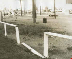
Edmonds Bus Loop
https://search.heritageburnaby.ca/link/archivedescription34597
- Repository
- City of Burnaby Archives
- Date
- July 15, 1966
- Collection/Fonds
- Burnaby Historical Society fonds
- Description Level
- Item
- Physical Description
- 1 photograph : b&w negative ; 4.7 x 4.6 cm
- Scope and Content
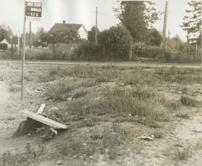
- Photograph of the Edmonds Bus Loop at Edmonds Street and Kingsway with a broken fence in the foreground. No buses are visible.
- Repository
- City of Burnaby Archives
- Date
- July 15, 1966
- Collection/Fonds
- Burnaby Historical Society fonds
- Subseries
- Photographs subseries
- Physical Description
- 1 photograph : b&w negative ; 4.7 x 4.6 cm
- Description Level
- Item
- Record No.
- 066-001
- Access Restriction
- No restrictions
- Reproduction Restriction
- Reproduce for fair dealing purposes only
- Accession Number
- BHS2007-04
- Scope and Content
- Photograph of the Edmonds Bus Loop at Edmonds Street and Kingsway with a broken fence in the foreground. No buses are visible.
- Subjects
- Transportation - Public Transit
- Media Type
- Photograph
- Notes
- Title based on contents of photograph
- 1 b&w photograph accompanying
- Geographic Access
- Kingsway
- Edmonds Street
- Historic Neighbourhood
- Edmonds (Historic Neighbourhood)
- Planning Study Area
- Stride Avenue Area
Images


Edmonds Bus Loop
https://search.heritageburnaby.ca/link/archivedescription34598
- Repository
- City of Burnaby Archives
- Date
- July 15, 1966
- Collection/Fonds
- Burnaby Historical Society fonds
- Description Level
- Item
- Physical Description
- 1 photograph : b&w negative ; 4.4 x 4.5 cm
- Scope and Content
- Photograph of the Edmonds Bus Loop at Edmonds Street and Kingsway. There is a bus stop sign for the 31 Douglas and 58 SFU with "For bus information phone 261-4211" written at the bottom. No buses are visible.
- Repository
- City of Burnaby Archives
- Date
- July 15, 1966
- Collection/Fonds
- Burnaby Historical Society fonds
- Subseries
- Photographs subseries
- Physical Description
- 1 photograph : b&w negative ; 4.4 x 4.5 cm
- Description Level
- Item
- Record No.
- 066-002
- Access Restriction
- No restrictions
- Reproduction Restriction
- Reproduce for fair dealing purposes only
- Accession Number
- BHS2007-04
- Scope and Content
- Photograph of the Edmonds Bus Loop at Edmonds Street and Kingsway. There is a bus stop sign for the 31 Douglas and 58 SFU with "For bus information phone 261-4211" written at the bottom. No buses are visible.
- Subjects
- Transportation - Public Transit
- Media Type
- Photograph
- Notes
- Title based on contents of photograph
- 1 b&w photograph accompanying
- Geographic Access
- Kingsway
- Edmonds Street
- Historic Neighbourhood
- Edmonds (Historic Neighbourhood)
- Planning Study Area
- Stride Avenue Area
Images
Edmonds Bus Loop
https://search.heritageburnaby.ca/link/archivedescription34600
- Repository
- City of Burnaby Archives
- Date
- July 15, 1966
- Collection/Fonds
- Burnaby Historical Society fonds
- Description Level
- Item
- Physical Description
- 1 photograph : b&w negative ; 4.5 x 4.6 cm
- Scope and Content
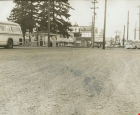
- Photograph of the Edmonds Bus Loop at Edmonds Street and Kingsway including two buses, a bus shelter, and a telephone booth. Stores and billboards, including one for "Mounties play-by-play" on CKWX, can be seen in the background.
- Repository
- City of Burnaby Archives
- Date
- July 15, 1966
- Collection/Fonds
- Burnaby Historical Society fonds
- Subseries
- Photographs subseries
- Physical Description
- 1 photograph : b&w negative ; 4.5 x 4.6 cm
- Description Level
- Item
- Record No.
- 066-004
- Access Restriction
- No restrictions
- Reproduction Restriction
- Reproduce for fair dealing purposes only
- Accession Number
- BHS2007-04
- Scope and Content
- Photograph of the Edmonds Bus Loop at Edmonds Street and Kingsway including two buses, a bus shelter, and a telephone booth. Stores and billboards, including one for "Mounties play-by-play" on CKWX, can be seen in the background.
- Subjects
- Transportation - Public Transit
- Media Type
- Photograph
- Notes
- Title based on contents of photograph
- 1 b&w photograph accompanying
- Geographic Access
- Kingsway
- Edmonds Street
- Historic Neighbourhood
- Edmonds (Historic Neighbourhood)
- Planning Study Area
- Stride Avenue Area
Images

Edmonds Bus Loop
https://search.heritageburnaby.ca/link/archivedescription34601
- Repository
- City of Burnaby Archives
- Date
- July 15, 1966
- Collection/Fonds
- Burnaby Historical Society fonds
- Description Level
- Item
- Physical Description
- 1 photograph : b&w negative ; 4.6 x 4.6 cm
- Scope and Content
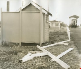
- Photograph of the Edmonds Bus Loop at Edmonds Street and Kingsway, including a broken fence. Interurban tram no. 1223 is visible in the upper right of the photograph.
- Repository
- City of Burnaby Archives
- Date
- July 15, 1966
- Collection/Fonds
- Burnaby Historical Society fonds
- Subseries
- Photographs subseries
- Physical Description
- 1 photograph : b&w negative ; 4.6 x 4.6 cm
- Description Level
- Item
- Record No.
- 066-005
- Access Restriction
- No restrictions
- Reproduction Restriction
- Reproduce for fair dealing purposes only
- Accession Number
- BHS2007-04
- Scope and Content
- Photograph of the Edmonds Bus Loop at Edmonds Street and Kingsway, including a broken fence. Interurban tram no. 1223 is visible in the upper right of the photograph.
- Subjects
- Transportation - Public Transit
- Media Type
- Photograph
- Notes
- Title based on contents of photograph
- 1 b&w photograph accompanying
- Geographic Access
- Kingsway
- Edmonds Street
- Historic Neighbourhood
- Edmonds (Historic Neighbourhood)
- Planning Study Area
- Stride Avenue Area
Images


Edmonds Bus Loop
https://search.heritageburnaby.ca/link/archivedescription34602
- Repository
- City of Burnaby Archives
- Date
- July 15, 1966
- Collection/Fonds
- Burnaby Historical Society fonds
- Description Level
- Item
- Physical Description
- 1 photograph : b&w negative ; 4.4 x 4.6 cm
- Scope and Content
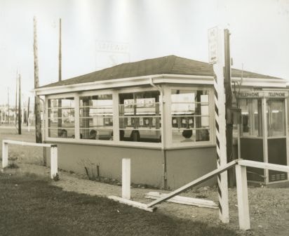
- Photograph of the Edmonds Bus Loop at Edmonds Street and Kingsway, including a bus shelter and telephone booth with a broken fence in front. A Safeway sign can be seen in the background.
- Repository
- City of Burnaby Archives
- Date
- July 15, 1966
- Collection/Fonds
- Burnaby Historical Society fonds
- Subseries
- Photographs subseries
- Physical Description
- 1 photograph : b&w negative ; 4.4 x 4.6 cm
- Description Level
- Item
- Record No.
- 066-006
- Access Restriction
- No restrictions
- Reproduction Restriction
- Reproduce for fair dealing purposes only
- Accession Number
- BHS2007-04
- Scope and Content
- Photograph of the Edmonds Bus Loop at Edmonds Street and Kingsway, including a bus shelter and telephone booth with a broken fence in front. A Safeway sign can be seen in the background.
- Subjects
- Transportation - Public Transit
- Media Type
- Photograph
- Notes
- Title based on contents of photograph
- 1 b&w photograph accompanying
- Geographic Access
- Kingsway
- Edmonds Street
- Historic Neighbourhood
- Edmonds (Historic Neighbourhood)
- Planning Study Area
- Stride Avenue Area
Images