Narrow Results By
Burnaby Council
https://search.heritageburnaby.ca/link/archivedescription55647
- Repository
- City of Burnaby Archives
- Date
- 1954
- Collection/Fonds
- Charles MacSorley fonds
- Description Level
- Item
- Physical Description
- 1 photograph : b&w ; 17 x 25.5 cm
- Scope and Content
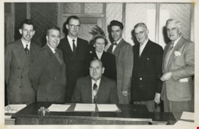
- Photograph of the eight members of Burnaby's 1954 Municipal Council. From left to right they are; Fred Philps, Wesley Morrison, Arnold Hean, Reeve Charles MacSorley (seated), Patricia Wilks, Sam Hughes, William Philps, and Gerald Charlton. This photograph was likely taken in Burnaby Municipal Hall.
- Repository
- City of Burnaby Archives
- Date
- 1954
- Collection/Fonds
- Charles MacSorley fonds
- Physical Description
- 1 photograph : b&w ; 17 x 25.5 cm
- Description Level
- Item
- Record No.
- 486-041
- Access Restriction
- No restrictions
- Reproduction Restriction
- Reproduce for fair dealing purposes only
- Accession Number
- 2005-14
- Scope and Content
- Photograph of the eight members of Burnaby's 1954 Municipal Council. From left to right they are; Fred Philps, Wesley Morrison, Arnold Hean, Reeve Charles MacSorley (seated), Patricia Wilks, Sam Hughes, William Philps, and Gerald Charlton. This photograph was likely taken in Burnaby Municipal Hall.
- Names
- Philps, Fred
- Philps, William P.
- Morrison, Wesley
- Hean, Arnold F.C.
- MacSorley, Charles W.
- Wilks, Patricia
- Hughes, Samuel E.
- Charlton, Gerald
- Media Type
- Photograph
- Photographer
- Davis, W.T.
- Notes
- Title based on contents of photograph
- Photographer's stamp on verso
- Note on verso identifies the people in the photograph
- Note on verso reads: "1954"
- Geographic Access
- Kingsway
- Street Address
- 7282 Kingsway
- Historic Neighbourhood
- Edmonds (Historic Neighbourhood)
- Planning Study Area
- Stride Avenue Area
Images


Byrne Creek
https://search.heritageburnaby.ca/link/archivedescription91705
- Repository
- City of Burnaby Archives
- Date
- March 25, 1993
- Collection/Fonds
- Doreen Lawson fonds
- Description Level
- File
- Physical Description
- 40 photographs : col. slides ; 35 mm
- Scope and Content
- File consists of photographs of Byrne Creek. The photographs depict the creek prior to clean-up with the water and paths littered with debris. Also included in the file are photographs of an unidentified man pulling a dead fish from the creek.
- Repository
- City of Burnaby Archives
- Date
- March 25, 1993
- Collection/Fonds
- Doreen Lawson fonds
- Physical Description
- 40 photographs : col. slides ; 35 mm
- Description Level
- File
- Record No.
- 618-023
- Access Restriction
- No restrictions
- Reproduction Restriction
- No restrictions
- Accession Number
- 2015-15
- Scope and Content
- File consists of photographs of Byrne Creek. The photographs depict the creek prior to clean-up with the water and paths littered with debris. Also included in the file are photographs of an unidentified man pulling a dead fish from the creek.
- Media Type
- Photograph
- Photographer
- Lawson, Doreen A.
- Glover, Ken
- Notes
- Transcribed title
- Title transcribed from label on slide sheets
- Note in black ink on recto of slide frames 618-023-11, 618-023-12, 618-023-14, 618-023-33, and 618-023-40 reads: "Ken Glover / BOB"
- Geographic Access
- Byrne Creek
- Historic Neighbourhood
- Edmonds (Historic Neighbourhood)
- Planning Study Area
- Stride Avenue Area
Images


Municipality of Burnaby- Volume XV and Volume XVIII
https://search.heritageburnaby.ca/link/museumdescription8686
- Repository
- Burnaby Village Museum
- Date
- May 1927
- Collection/Fonds
- Burnaby Village Museum Map collection
- Description Level
- File
- Physical Description
- 4 plans on 4 sheets : col. lithographic prints ; 63.5 x 53.5 cm folded to 53 x 31.5 cm
- Scope and Content
- File consists of four pages of plans removed from a bound book containing a series of fire insurance plans of the Municipality of Burnaby. Plan "1520" is part of "GREATER VANCOUVER B.C. / VOLUME XV / Municipality of Burnaby / May 1927" and covers District Lots: 121 and 187. Plann "1521" is part of …
- Repository
- Burnaby Village Museum
- Collection/Fonds
- Burnaby Village Museum Map collection
- Description Level
- File
- Physical Description
- 4 plans on 4 sheets : col. lithographic prints ; 63.5 x 53.5 cm folded to 53 x 31.5 cm
- Material Details
- Scale [1:600] and [1:1200]
- Scope and Content
- File consists of four pages of plans removed from a bound book containing a series of fire insurance plans of the Municipality of Burnaby. Plan "1520" is part of "GREATER VANCOUVER B.C. / VOLUME XV / Municipality of Burnaby / May 1927" and covers District Lots: 121 and 187. Plann "1521" is part of "GREATER VANCOUVER B.C. / VOLUME XV / Municipality of Burnaby / May 1927" and covers District Lots: 121 and 187. Key plan "H" reads: "GREATER VANCOUVER B.C. / VOLUME XVIII / Surveyed _ May 1927 / MUNICIPALITY OF / BURNABY" and covers plans: 1813 to 1822; 1824 to 1832; 1839; 1840; 1853 to 1865 and District Lots: 28; 30; 53; 90 to 93; 95 to 97; 155a; 155b; 155c; 159; 160; 171 to 173. Plan "1801" is part of "GREATER VANCOUVER B.C. / VOLUME XVIII / Municipality of Burnaby / May 1927" and covers District Lot 153.
- Responsibility
- British Columbia Underwriters' Association
- Accession Code
- HV972.111.8
- Access Restriction
- No restrictions
- Reproduction Restriction
- May be restricted by third party rights
- Date
- May 1927
- Media Type
- Cartographic Material
- Historic Neighbourhood
- Fraser Arm (Historic Neighbourhood)
- Vancouver Heights (Historic Neighbourhood)
- East Burnaby (Historic Neighbourhood)
- Edmonds (Historic Neighbourhood)
- Planning Study Area
- Marlborough Area
- Kingsway-Beresford Area
- Windsor Area
- Big Bend Area
- Clinton-Glenwood Area
- Burnaby Heights Area
- Edmonds Area
- Stride Avenue Area
- Scan Resolution
- 400
- Scan Date
- 2021-11-18
- Notes
- Title based on content of plans
- See also BV987.1.70d for revised versions of plans
- Scale is measured 1 inch = 500 feet
