Narrow Results By
Subject
- Advertising Medium - Signs and Signboards 7
- Aerial Photographs 8
- Agriculture - Farms 1
- Animals - Dogs 6
- Animals - Horses 1
- Buildings - Agricultural - Barns 2
- Buildings - Civic - Fire Halls 1
- Buildings - Commercial - Grocery Stores 2
- Buildings - Residential - Apartments 1
- Buildings - Residential - Houses 29
- Buildings - Residential - Seniors Housing 2
- Buildings - Schools 8
Aerial photograph of Burnaby
https://search.heritageburnaby.ca/link/archivedescription84892
- Repository
- City of Burnaby Archives
- Date
- 1963
- Collection/Fonds
- Allan Amundsen collection
- Description Level
- Item
- Physical Description
- 1 photograph : b&w ; 22.5 x 22.5 cm
- Scope and Content
- Aerial photograph of Burnaby north of Lougheed Highway.
- Repository
- City of Burnaby Archives
- Date
- 1963
- Collection/Fonds
- Allan Amundsen collection
- Physical Description
- 1 photograph : b&w ; 22.5 x 22.5 cm
- Description Level
- Item
- Record No.
- 561-013
- Access Restriction
- In Archives only
- Reproduction Restriction
- No reproduction permitted
- Accession Number
- 2014-08
- Scope and Content
- Aerial photograph of Burnaby north of Lougheed Highway.
- Subjects
- Aerial Photographs
- Media Type
- Photograph
- Photographer
- Province of British Columbia
- Notes
- Title based on contents of photograph
- This photo is indentified as BC5061:118 and connects with B.C. air photograph BC5061:117 to the west and BC5061:119 to the east
- Historic Neighbourhood
- Burnaby Lake (Historic Neighbourhood)
- Lozells (Historic Neighbourhood)
- Planning Study Area
- Parkcrest-Aubrey Area
- Ardingley-Sprott Area
- Sperling-Broadway Area
- Government Road Area
Aerial photograph of Burnaby
https://search.heritageburnaby.ca/link/archivedescription84893
- Repository
- City of Burnaby Archives
- Date
- 1963
- Collection/Fonds
- Allan Amundsen collection
- Description Level
- Item
- Physical Description
- 1 photograph : b&w ; 22.5 x 22.5 cm
- Scope and Content
- Aerial photograph of Burnaby north of Lougheed Highway and west of Sperling Avenue.
- Repository
- City of Burnaby Archives
- Date
- 1963
- Collection/Fonds
- Allan Amundsen collection
- Physical Description
- 1 photograph : b&w ; 22.5 x 22.5 cm
- Description Level
- Item
- Record No.
- 561-014
- Access Restriction
- In Archives only
- Reproduction Restriction
- No reproduction permitted
- Accession Number
- 2014-08
- Scope and Content
- Aerial photograph of Burnaby north of Lougheed Highway and west of Sperling Avenue.
- Subjects
- Aerial Photographs
- Media Type
- Photograph
- Photographer
- Province of British Columbia
- Notes
- Title based on contents of photograph
- This photo is indentified as BC5061:119 and connects with B.C. air photograph BC5061:118 to the west and BC5061:120 to the east
- Geographic Access
- Burnaby Mountain Conservation Area
- Historic Neighbourhood
- Lozells (Historic Neighbourhood)
- Planning Study Area
- Sperling-Broadway Area
- Lake City Area
- Government Road Area
Aerial photograph of Burnaby
https://search.heritageburnaby.ca/link/archivedescription84894
- Repository
- City of Burnaby Archives
- Date
- 1963
- Collection/Fonds
- Allan Amundsen collection
- Description Level
- Item
- Physical Description
- 1 photograph : b&w ; 22.5 x 22.5 cm
- Scope and Content
- Aerial photograph of Burnaby north of Broadway and west of Sperling Avenue.
- Repository
- City of Burnaby Archives
- Date
- 1963
- Collection/Fonds
- Allan Amundsen collection
- Physical Description
- 1 photograph : b&w ; 22.5 x 22.5 cm
- Description Level
- Item
- Record No.
- 561-015
- Access Restriction
- In Archives only
- Reproduction Restriction
- No reproduction permitted
- Accession Number
- 2014-08
- Scope and Content
- Aerial photograph of Burnaby north of Broadway and west of Sperling Avenue.
- Subjects
- Aerial Photographs
- Media Type
- Photograph
- Photographer
- Province of British Columbia
- Notes
- Title based on contents of photograph
- This photo is indentified as BC5061:120 and connects with B.C. air photograph BC5061:119 to the west and BC5061:121 to the east
- Geographic Access
- Burnaby Mountain Conservation Area
- Historic Neighbourhood
- Lozells (Historic Neighbourhood)
- Planning Study Area
- Sperling-Broadway Area
- Lake City Area
- Government Road Area
- Burnaby Mountain Area
Aerial photograph of Burnaby
https://search.heritageburnaby.ca/link/archivedescription84896
- Repository
- City of Burnaby Archives
- Date
- 1963
- Collection/Fonds
- Allan Amundsen collection
- Description Level
- Item
- Physical Description
- 1 photograph : b&w ; 22.5 x 22.5 cm
- Scope and Content
- Aerial photograph of Burnaby north of Broadway and west of Sperling Avenue.
- Repository
- City of Burnaby Archives
- Date
- 1963
- Collection/Fonds
- Allan Amundsen collection
- Physical Description
- 1 photograph : b&w ; 22.5 x 22.5 cm
- Description Level
- Item
- Record No.
- 561-016
- Access Restriction
- In Archives only
- Reproduction Restriction
- No reproduction permitted
- Accession Number
- 2014-08
- Scope and Content
- Aerial photograph of Burnaby north of Broadway and west of Sperling Avenue.
- Subjects
- Aerial Photographs
- Media Type
- Photograph
- Photographer
- Province of British Columbia
- Notes
- Title based on contents of photograph
- This photo is indentified as BC5061:121 and connects with B.C. air photograph BC5061:120 to the west and BC5061:122 to the east
- Geographic Access
- Burnaby Mountain Conservation Area
- Historic Neighbourhood
- Lozells (Historic Neighbourhood)
- Planning Study Area
- Sperling-Broadway Area
- Lake City Area
- Government Road Area
- Burnaby Mountain Area
Aerial photograph of Burnaby Lake Area
https://search.heritageburnaby.ca/link/archivedescription84908
- Repository
- City of Burnaby Archives
- Date
- 1963
- Collection/Fonds
- Allan Amundsen collection
- Description Level
- Item
- Physical Description
- 1 photograph : b&w ; 22.5 x 22.5 cm
- Scope and Content
- Aerial photograph of Burnaby with Lougheed Highway in the north west corner, the Trans Canada Highway in the south east corner and Burnaby Lake appearing from the west.
- Repository
- City of Burnaby Archives
- Date
- 1963
- Collection/Fonds
- Allan Amundsen collection
- Physical Description
- 1 photograph : b&w ; 22.5 x 22.5 cm
- Description Level
- Item
- Record No.
- 561-026
- Access Restriction
- In Archives only
- Reproduction Restriction
- No reproduction permitted
- Accession Number
- 2014-08
- Scope and Content
- Aerial photograph of Burnaby with Lougheed Highway in the north west corner, the Trans Canada Highway in the south east corner and Burnaby Lake appearing from the west.
- Subjects
- Aerial Photographs
- Media Type
- Photograph
- Photographer
- Province of British Columbia
- Notes
- Title based on contents of photograph
- This photo is indentified as BC5062:25 and connects with B.C. air photograph BC5062:26 to the west and B.C. air photograph BC5062:24 to the east
- Historic Neighbourhood
- Burnaby Lake (Historic Neighbourhood)
- Lozells (Historic Neighbourhood)
- Planning Study Area
- Douglas-Gilpin Area
- Sperling-Broadway Area
- Government Road Area
- Burnaby Lake Area
Aerial photograph of Burnaby Lake Area
https://search.heritageburnaby.ca/link/archivedescription84909
- Repository
- City of Burnaby Archives
- Date
- 1963
- Collection/Fonds
- Allan Amundsen collection
- Description Level
- Item
- Physical Description
- 1 photograph : b&w ; 22.5 x 22.5 cm
- Scope and Content
- Aerial photograph of Burnaby with Lougheed Highway to the north and Burnaby Lake to the south.
- Repository
- City of Burnaby Archives
- Date
- 1963
- Collection/Fonds
- Allan Amundsen collection
- Physical Description
- 1 photograph : b&w ; 22.5 x 22.5 cm
- Description Level
- Item
- Record No.
- 561-027
- Access Restriction
- In Archives only
- Reproduction Restriction
- No reproduction permitted
- Accession Number
- 2014-08
- Scope and Content
- Aerial photograph of Burnaby with Lougheed Highway to the north and Burnaby Lake to the south.
- Subjects
- Aerial Photographs
- Media Type
- Photograph
- Photographer
- Province of British Columbia
- Notes
- Title based on contents of photograph
- This photo is indentified as BC5062:24 and connects with B.C. air photograph BC5062:25 to the west and B.C. air photograph BC5062:23 to the east
- Historic Neighbourhood
- Burnaby Lake (Historic Neighbourhood)
- Lozells (Historic Neighbourhood)
- Planning Study Area
- Douglas-Gilpin Area
- Sperling-Broadway Area
- Government Road Area
- Burnaby Lake Area
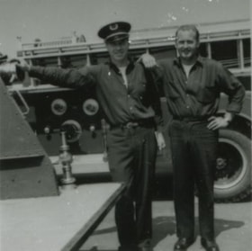
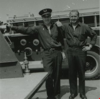
Basil Pontifex and Norm Brooke
https://search.heritageburnaby.ca/link/archivedescription37927
- Repository
- City of Burnaby Archives
- Date
- 1957 (date of original), copied 1991
- Collection/Fonds
- Burnaby Historical Society fonds
- Description Level
- Item
- Physical Description
- 1 photograph : b&w ; 3.0 x 3.0 cm print on contact sheet 20.7 x 26.5 cm
- Scope and Content
- Photograph of firefighters Basil Pontifex and Norm Brooke at Fire Hall No. 4 at 2326 Duthie Avenue. A firetruck can be seen behind them.
- Repository
- City of Burnaby Archives
- Date
- 1957 (date of original), copied 1991
- Collection/Fonds
- Burnaby Historical Society fonds
- Subseries
- Burnaby Image Bank subseries
- Physical Description
- 1 photograph : b&w ; 3.0 x 3.0 cm print on contact sheet 20.7 x 26.5 cm
- Description Level
- Item
- Record No.
- 370-515
- Access Restriction
- No restrictions
- Reproduction Restriction
- No restrictions
- Accession Number
- BHS1999-03
- Scope and Content
- Photograph of firefighters Basil Pontifex and Norm Brooke at Fire Hall No. 4 at 2326 Duthie Avenue. A firetruck can be seen behind them.
- Media Type
- Photograph
- Notes
- Title based on contents of photograph
- 1 b&w copy negative accompanying
- Negative has a pink cast
- Geographic Access
- Duthie Avenue
- Street Address
- 2326 Duthie Avenue
- Historic Neighbourhood
- Lochdale (Historic Neighbourhood)
- Planning Study Area
- Sperling-Broadway Area
Images

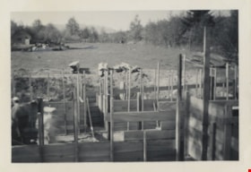
Birth of a House
https://search.heritageburnaby.ca/link/archivedescription79788
- Repository
- City of Burnaby Archives
- Date
- May 1950
- Collection/Fonds
- Yanko family fonds
- Description Level
- Item
- Physical Description
- 1 photograph : b&w ; 8 x 5.5 cm
- Scope and Content
- Photograph of the construction site for the Yanko family house at 7385 Broadway (later renumbered 7391) in Burnaby.
- Repository
- City of Burnaby Archives
- Date
- May 1950
- Collection/Fonds
- Yanko family fonds
- Physical Description
- 1 photograph : b&w ; 8 x 5.5 cm
- Material Details
- Secured to album page with photo corners
- Description Level
- Item
- Record No.
- 545-438
- Access Restriction
- No restrictions
- Reproduction Restriction
- No restrictions
- Accession Number
- 2012-09
- Scope and Content
- Photograph of the construction site for the Yanko family house at 7385 Broadway (later renumbered 7391) in Burnaby.
- Subjects
- Construction
- Land Clearing
- Media Type
- Photograph
- Notes
- Transcribed title (from album page)
- Note written on album page reads: "'Birth of a House' / Started May 1950 / Moved in April 6, 1951"
- Note in black ink on verso of photograph reads: "#6 House May 1950"
- Street Address
- 7391 Broadway
- Planning Study Area
- Sperling-Broadway Area
Images

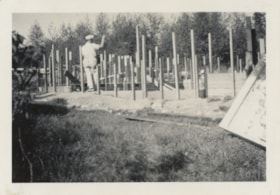
Birth of a House
https://search.heritageburnaby.ca/link/archivedescription79793
- Repository
- City of Burnaby Archives
- Date
- May 1950
- Collection/Fonds
- Yanko family fonds
- Description Level
- Item
- Physical Description
- 1 photograph : b&w ; 5.5 x 8 cm
- Scope and Content
- Photograph of the construction of the Yanko family house at 7385 Broadway (later renumbered 7391) in Burnaby. Two unidentified men are visible at left, working to install wood beams, joists and support posts.
- Repository
- City of Burnaby Archives
- Date
- May 1950
- Collection/Fonds
- Yanko family fonds
- Physical Description
- 1 photograph : b&w ; 5.5 x 8 cm
- Material Details
- Secured to album page with photo corners
- Description Level
- Item
- Record No.
- 545-439
- Access Restriction
- No restrictions
- Reproduction Restriction
- No restrictions
- Accession Number
- 2012-09
- Scope and Content
- Photograph of the construction of the Yanko family house at 7385 Broadway (later renumbered 7391) in Burnaby. Two unidentified men are visible at left, working to install wood beams, joists and support posts.
- Media Type
- Photograph
- Notes
- Transcribed title (from album page)
- Note written on album page reads: "'Birth of a House' / Started May 1950 / Moved in April 6, 1951"
- Note in black ink on verso of photograph reads: "#1 House May 1950" and "up to that line; is all our land 84' x 86' / 26'6" 34' 23' [diagram] - House / I'll send you the plan"
- Street Address
- 7391 Broadway
- Planning Study Area
- Sperling-Broadway Area
Images


Birth of a House
https://search.heritageburnaby.ca/link/archivedescription79794
- Repository
- City of Burnaby Archives
- Date
- May 24, 1950
- Collection/Fonds
- Yanko family fonds
- Description Level
- Item
- Physical Description
- 1 photograph : b&w ; 5.5 x 8 cm
- Scope and Content
- Photograph of three unidentified men at the construction site for the Yanko family house at 7385 Broadway (later renumbered 7391) in Burnaby.
- Repository
- City of Burnaby Archives
- Date
- May 24, 1950
- Collection/Fonds
- Yanko family fonds
- Physical Description
- 1 photograph : b&w ; 5.5 x 8 cm
- Material Details
- Secured to album page with photo corners
- Description Level
- Item
- Record No.
- 545-440
- Access Restriction
- No restrictions
- Reproduction Restriction
- No restrictions
- Accession Number
- 2012-09
- Scope and Content
- Photograph of three unidentified men at the construction site for the Yanko family house at 7385 Broadway (later renumbered 7391) in Burnaby.
- Subjects
- Construction
- Media Type
- Photograph
- Notes
- Transcribed title (from album page)
- Note written on album page reads: "'Birth of a House' / Started May 1950 / Moved in April 6, 1951" and "24 May 1950"
- Note in black ink on verso of photograph reads: "House # 2" and "May 24/50"
- Street Address
- 7391 Broadway
- Planning Study Area
- Sperling-Broadway Area
Images

Birth of a House
https://search.heritageburnaby.ca/link/archivedescription79795
- Repository
- City of Burnaby Archives
- Date
- May 1950
- Collection/Fonds
- Yanko family fonds
- Description Level
- Item
- Physical Description
- 1 photograph : b&w ; 5.5 x 8 cm
- Scope and Content
- Photograph of an unidentified man who appears to be hammering wooden support posts into a concrete foundation during the construction of the Yanko family house at 7385 Broadway (later renumbered 7391) in Burnaby.
- Repository
- City of Burnaby Archives
- Date
- May 1950
- Collection/Fonds
- Yanko family fonds
- Physical Description
- 1 photograph : b&w ; 5.5 x 8 cm
- Material Details
- Secured to album page with photo corners
- Description Level
- Item
- Record No.
- 545-441
- Access Restriction
- No restrictions
- Reproduction Restriction
- No restrictions
- Accession Number
- 2012-09
- Scope and Content
- Photograph of an unidentified man who appears to be hammering wooden support posts into a concrete foundation during the construction of the Yanko family house at 7385 Broadway (later renumbered 7391) in Burnaby.
- Media Type
- Photograph
- Notes
- Transcribed title (from album page)
- Note written on album page reads: "'Birth of a House' / Started May 1950 / Moved in April 6, 1951"
- Note in black ink on verso of photograph reads: "House # 4" and "May 1950"
- Street Address
- 7391 Broadway
- Planning Study Area
- Sperling-Broadway Area
Images

![Burnaby Lake, [193-] thumbnail](/media/hpo/_Data/_Archives_Images/_Unrestricted/001/072-001.jpg?width=280)
Burnaby Lake
https://search.heritageburnaby.ca/link/archivedescription34637
- Repository
- City of Burnaby Archives
- Date
- [193-]
- Collection/Fonds
- Burnaby Historical Society fonds
- Description Level
- Item
- Physical Description
- 1 photograph : b&w ; 12.7 x 20.3 cm
- Scope and Content
- Aerial photograph of Burnaby Lake and North Burnaby.
- Repository
- City of Burnaby Archives
- Date
- [193-]
- Collection/Fonds
- Burnaby Historical Society fonds
- Subseries
- Photographs subseries
- Physical Description
- 1 photograph : b&w ; 12.7 x 20.3 cm
- Description Level
- Item
- Record No.
- 072-001
- Access Restriction
- No restrictions
- Reproduction Restriction
- No known restrictions
- Accession Number
- BHS2007-04
- Scope and Content
- Aerial photograph of Burnaby Lake and North Burnaby.
- Media Type
- Photograph
- Notes
- Title based on contents of photograph
- Geographic Access
- Burnaby Lake
- Historic Neighbourhood
- Burnaby Lake (Historic Neighbourhood)
- Lozells (Historic Neighbourhood)
- Lochdale (Historic Neighbourhood)
- Planning Study Area
- Parkcrest-Aubrey Area
- Ardingley-Sprott Area
- Burnaby Lake Area
- Government Road Area
- Sperling-Broadway Area
- Lochdale Area
Images
![Burnaby Lake, [193-] thumbnail](/media/hpo/_Data/_Archives_Images/_Unrestricted/001/072-001.jpg)
![Burnaby Mountain driving range in snow, [2002] thumbnail](/media/hpo/_Data/_Archives_Images/_Unrestricted/535/535-1964.jpg?width=280)
Burnaby Mountain driving range in snow
https://search.heritageburnaby.ca/link/archivedescription96281
- Repository
- City of Burnaby Archives
- Date
- [2002]
- Collection/Fonds
- Burnaby NewsLeader photograph collection
- Description Level
- Item
- Physical Description
- 1 photograph (tiff) : col.
- Scope and Content
- Photograph of Brian Jae preparing a swing at the Burnaby Mountain Golf Club driving range. The grass is covered in snow.
- Repository
- City of Burnaby Archives
- Date
- [2002]
- Collection/Fonds
- Burnaby NewsLeader photograph collection
- Physical Description
- 1 photograph (tiff) : col.
- Description Level
- Item
- Record No.
- 535-1964
- Access Restriction
- No restrictions
- Reproduction Restriction
- No restrictions
- Accession Number
- 2018-12
- Scope and Content
- Photograph of Brian Jae preparing a swing at the Burnaby Mountain Golf Club driving range. The grass is covered in snow.
- Media Type
- Photograph
- Photographer
- Bartel, Mario
- Notes
- Title based on caption
- Collected by editorial for use in a January 2002 issue of the Burnaby NewsLeader
- Caption from metadata: "Brian Jae doesn't let the fresh snow keep him from honing his golf swing at the driving range at Burnaby Mountain Golf Club. He says he uses balls with a red stripe on them so he can spot them against the white ground."
- Geographic Access
- Halifax Street
- Street Address
- 7600 Halifax Street
- Historic Neighbourhood
- Lochdale (Historic Neighbourhood)
- Planning Study Area
- Sperling-Broadway Area
Images
![Burnaby Mountain driving range in snow, [2002] thumbnail](/media/hpo/_Data/_Archives_Images/_Unrestricted/535/535-1964.jpg)
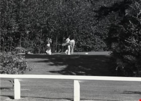
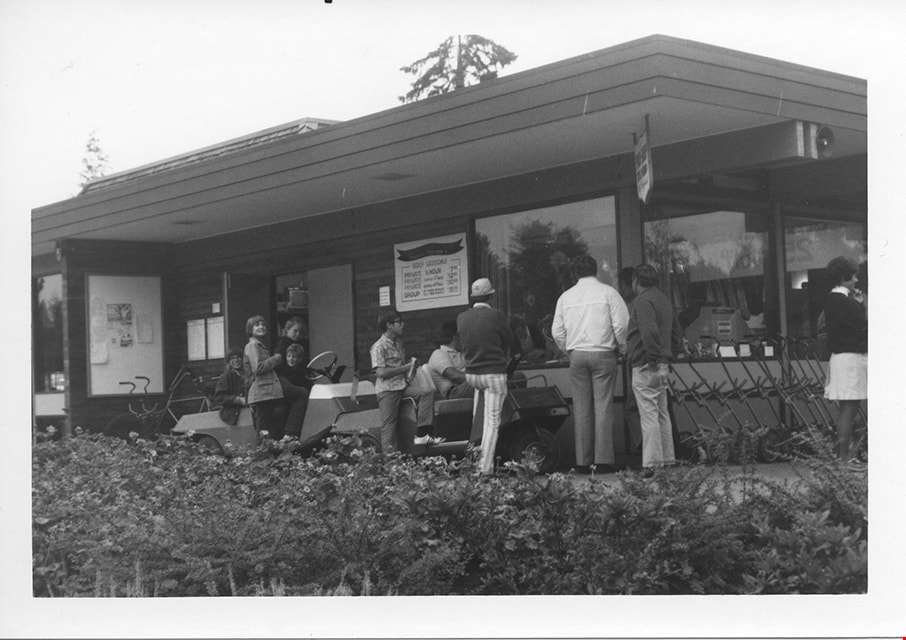
Burnaby Mountain Golf Course
https://search.heritageburnaby.ca/link/archivedescription79685
- Repository
- City of Burnaby Archives
- Date
- October, 1976
- Collection/Fonds
- Burnaby Public Library Contemporary Visual Archive Project
- Description Level
- Item
- Physical Description
- 1 photograph : b&w ; 11 x 16 cm mounted on cardboard
- Scope and Content
- Photograph shows golfers at Burnaby Mountain Golf Course, 7600 Halifax Street. Construction of the course began in September 1965; it opened to the public in May 1969. The course is 18 holes, 5418 yards long and covers 137 acres.
- Repository
- City of Burnaby Archives
- Date
- October, 1976
- Collection/Fonds
- Burnaby Public Library Contemporary Visual Archive Project
- Physical Description
- 1 photograph : b&w ; 11 x 16 cm mounted on cardboard
- Description Level
- Item
- Record No.
- 556-381
- Access Restriction
- No restrictions
- Reproduction Restriction
- Reproduce for fair dealing purposes only
- Accession Number
- 2013-13
- Scope and Content
- Photograph shows golfers at Burnaby Mountain Golf Course, 7600 Halifax Street. Construction of the course began in September 1965; it opened to the public in May 1969. The course is 18 holes, 5418 yards long and covers 137 acres.
- Subjects
- Recreational Activities - Golf
- Media Type
- Photograph
- Photographer
- Salmon, Stu
- Notes
- Scope note taken directly from BPL photograph description.
- Accompanying Burnaby Parks and Recreation Commission - Burnaby Mountain Golf Course informational document attached to verso.
- 1 b&w copy negative : 10 x 12.5 cm accompanying
- Geographic Access
- Halifax Street
- Street Address
- 7600 Halifax Street
- Planning Study Area
- Sperling-Broadway Area
Images
![Burnaby Mountain Golf Course, [2002] thumbnail](/media/hpo/_Data/_Archives_Images/_Unrestricted/535/535-2993.jpg?width=280)
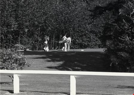
Burnaby Mountain Golf Course
https://search.heritageburnaby.ca/link/archivedescription97719
- Repository
- City of Burnaby Archives
- Date
- [2002]
- Collection/Fonds
- Burnaby NewsLeader photograph collection
- Description Level
- Item
- Physical Description
- 1 photograph (tiff) : b&w
- Scope and Content
- Photograph of unidentified golfer wheeling a golf caddy under a tree at Burnaby Mountain Golf Course.
- Repository
- City of Burnaby Archives
- Date
- [2002]
- Collection/Fonds
- Burnaby NewsLeader photograph collection
- Physical Description
- 1 photograph (tiff) : b&w
- Description Level
- Item
- Record No.
- 535-2993
- Access Restriction
- No restrictions
- Reproduction Restriction
- No restrictions
- Accession Number
- 2018-12
- Scope and Content
- Photograph of unidentified golfer wheeling a golf caddy under a tree at Burnaby Mountain Golf Course.
- Subjects
- Recreational Activities - Golf
- Media Type
- Photograph
- Photographer
- Bartel, Mario
- Notes
- Title based on caption
- Collected by editorial for use in a November 2002 issue of the Burnaby NewsLeader
- Caption from metadata: "The return of rainy weather doesn't keep intrepid golfers from their rounds at Burnaby Mountain Golf Course."
- Geographic Access
- Halifax Street
- Street Address
- 7600 Halifax Street
- Historic Neighbourhood
- Lochdale (Historic Neighbourhood)
- Planning Study Area
- Sperling-Broadway Area
Images
![Burnaby Mountain Golf Course, [2002] thumbnail](/media/hpo/_Data/_Archives_Images/_Unrestricted/535/535-2993.jpg)
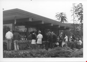
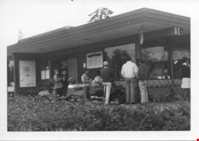
Burnaby Mountain Golf Course concession stand
https://search.heritageburnaby.ca/link/museumdescription2264
- Repository
- Burnaby Village Museum
- Date
- 11 Sept 1971
- Collection/Fonds
- Donald Copan collection
- Description Level
- Item
- Physical Description
- 1 photograph : b&w ; 8.9 x 12.7 cm
- Scope and Content
- Photograph of people standing outside of the concession stand at Burnaby Mountain Golf Course during the Centennial '71 Golf Tournament that took place on September 11, 1971.
- Repository
- Burnaby Village Museum
- Collection/Fonds
- Donald Copan collection
- Series
- Copan album series
- Description Level
- Item
- Physical Description
- 1 photograph : b&w ; 8.9 x 12.7 cm
- Scope and Content
- Photograph of people standing outside of the concession stand at Burnaby Mountain Golf Course during the Centennial '71 Golf Tournament that took place on September 11, 1971.
- Geographic Access
- Halifax Street
- Street Address
- 7600 Halifax Street
- Accession Code
- BV005.54.310
- Access Restriction
- No restrictions
- Reproduction Restriction
- May be restricted by third party rights
- Date
- 11 Sept 1971
- Media Type
- Photograph
- Historic Neighbourhood
- Lochdale (Historic Neighbourhood)
- Planning Study Area
- Sperling-Broadway Area
- Scan Resolution
- 600
- Scan Date
- July 23, 2020
- Scale
- 100
- Notes
- Title based on contents of photograph
Images
Burnaby Mountain Golf Course concession stand
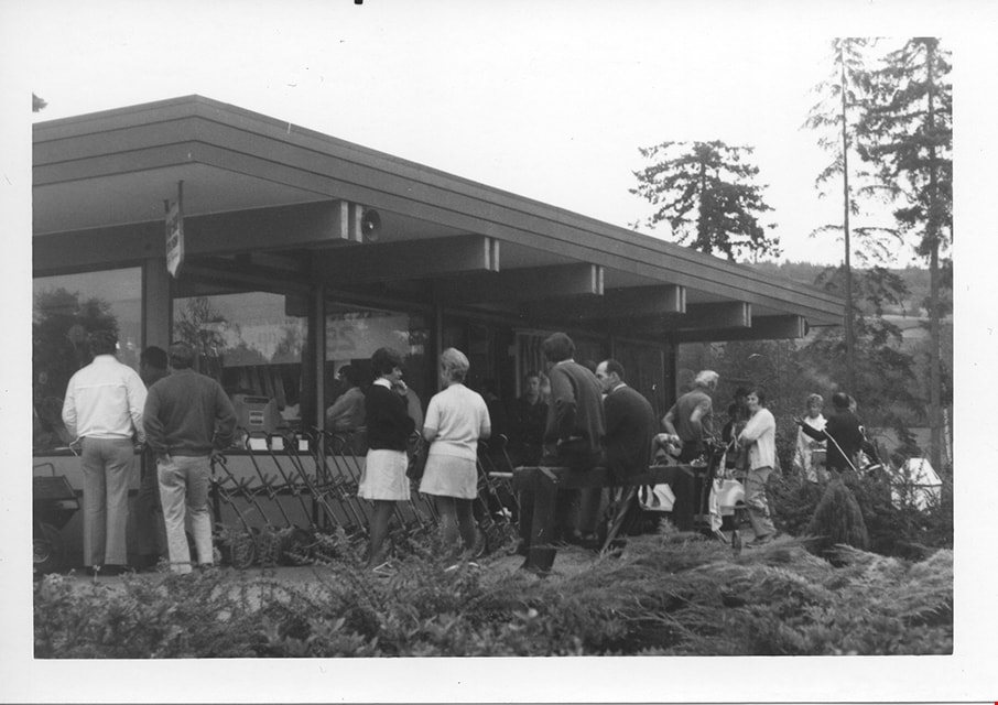
https://search.heritageburnaby.ca/link/museumdescription13295
- Repository
- Burnaby Village Museum
- Date
- 11 Sept 1971
- Collection/Fonds
- Donald Copan collection
- Description Level
- Item
- Physical Description
- 1 photograph : b&w ; 8.9 x 12.7 cm
- Scope and Content
- Photograph of people standing outside of the concession stand at Burnaby Mountain Golf Course during the Centennial '71 Golf Tournament that took place on September 11, 1971.
- Repository
- Burnaby Village Museum
- Collection/Fonds
- Donald Copan collection
- Series
- Copan album series
- Description Level
- Item
- Physical Description
- 1 photograph : b&w ; 8.9 x 12.7 cm
- Scope and Content
- Photograph of people standing outside of the concession stand at Burnaby Mountain Golf Course during the Centennial '71 Golf Tournament that took place on September 11, 1971.
- Geographic Access
- Halifax Street
- Street Address
- 7600 Halifax Street
- Accession Code
- BV005.54.311
- Access Restriction
- No restrictions
- Reproduction Restriction
- May be restricted by third party rights
- Date
- 11 Sept 1971
- Media Type
- Photograph
- Historic Neighbourhood
- Lochdale (Historic Neighbourhood)
- Planning Study Area
- Sperling-Broadway Area
- Scan Resolution
- 600
- Scan Date
- July 23, 2020
- Scale
- 100
- Notes
- Title based on contents of photograph
Images

Camrose Drive
https://search.heritageburnaby.ca/link/archivedescription79961
- Repository
- City of Burnaby Archives
- Date
- September 22, 1976
- Collection/Fonds
- Burnaby Public Library Contemporary Visual Archive Project
- Description Level
- Item
- Physical Description
- 1 photograph : b&w ; 11 x 16 cm mounted on cardboard
- Scope and Content
- Photograph shows a view down Camrose Drive, looking south.
- Repository
- City of Burnaby Archives
- Date
- September 22, 1976
- Collection/Fonds
- Burnaby Public Library Contemporary Visual Archive Project
- Physical Description
- 1 photograph : b&w ; 11 x 16 cm mounted on cardboard
- Description Level
- Item
- Record No.
- 556-524
- Access Restriction
- No restrictions
- Reproduction Restriction
- Reproduce for fair dealing purposes only
- Accession Number
- 2013-13
- Scope and Content
- Photograph shows a view down Camrose Drive, looking south.
- Media Type
- Photograph
- Photographer
- McCarron, John
- Notes
- Scope note taken directly from BPL photograph description.
- 1 b&w copy negative : 10 x 12.5 cm accompanying
- Geographic Access
- Camrose Drive
- Planning Study Area
- Sperling-Broadway Area
Images

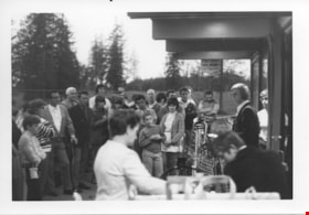
Centennial '71 Golf Tournament
https://search.heritageburnaby.ca/link/museumdescription13299
- Repository
- Burnaby Village Museum
- Date
- 11 Sept 1971
- Collection/Fonds
- Donald Copan collection
- Description Level
- Item
- Physical Description
- 1 photograph : b&w ; 8.9 x 12.7 cm
- Scope and Content
- Photograph of a group of people gathered for the Centennial '71 Golf Tournament which took place at Burnaby Mountain Golf Course on September 11, 1971.
- Repository
- Burnaby Village Museum
- Collection/Fonds
- Donald Copan collection
- Series
- Copan album series
- Description Level
- Item
- Physical Description
- 1 photograph : b&w ; 8.9 x 12.7 cm
- Scope and Content
- Photograph of a group of people gathered for the Centennial '71 Golf Tournament which took place at Burnaby Mountain Golf Course on September 11, 1971.
- Geographic Access
- Halifax Street
- Street Address
- 7600 Halifax Street
- Accession Code
- BV005.54.315
- Access Restriction
- No restrictions
- Reproduction Restriction
- May be restricted by third party rights
- Date
- 11 Sept 1971
- Media Type
- Photograph
- Historic Neighbourhood
- Lochdale (Historic Neighbourhood)
- Planning Study Area
- Sperling-Broadway Area
- Scan Resolution
- 600
- Scan Date
- July 23, 2020
- Scale
- 100
- Notes
- Title based on contents of photograph
Images

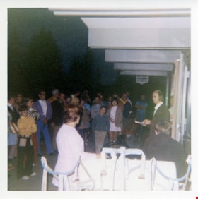
Centennial '71 Golf Tournament
https://search.heritageburnaby.ca/link/museumdescription13301
- Repository
- Burnaby Village Museum
- Date
- 11 Sept 1971
- Collection/Fonds
- Donald Copan collection
- Description Level
- Item
- Physical Description
- 1 photograph : col. ; 8.9 x 8.9 cm
- Scope and Content
- Photograph of a group of people gathered for the Centennial '71 Golf Tournament which took place at Burnaby Mountain Golf Course on September 11, 1971.
- Repository
- Burnaby Village Museum
- Collection/Fonds
- Donald Copan collection
- Series
- Copan album series
- Description Level
- Item
- Physical Description
- 1 photograph : col. ; 8.9 x 8.9 cm
- Scope and Content
- Photograph of a group of people gathered for the Centennial '71 Golf Tournament which took place at Burnaby Mountain Golf Course on September 11, 1971.
- Geographic Access
- Halifax Street
- Street Address
- 7600 Halifax Street
- Accession Code
- BV005.54.317
- Access Restriction
- No restrictions
- Reproduction Restriction
- May be restricted by third party rights
- Date
- 11 Sept 1971
- Media Type
- Photograph
- Historic Neighbourhood
- Lochdale (Historic Neighbourhood)
- Planning Study Area
- Sperling-Broadway Area
- Scan Resolution
- 600
- Scan Date
- July 23, 2020
- Scale
- 100
- Notes
- Title based on contents of photograph
Images
