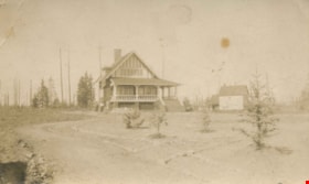
B.G. Walker house
https://search.heritageburnaby.ca/link/archivedescription36021
- Repository
- City of Burnaby Archives
- Date
- 1909
- Collection/Fonds
- Burnaby Historical Society fonds
- Description Level
- Item
- Physical Description
- 1 photograph : sepia postcard ; 8 x 14 cm
- Scope and Content
- Photographic postcard of the B.G. Walker House, at Edmonds & Kingsway.
- Repository
- City of Burnaby Archives
- Date
- 1909
- Collection/Fonds
- Burnaby Historical Society fonds
- Subseries
- Patterson family subseries
- Physical Description
- 1 photograph : sepia postcard ; 8 x 14 cm
- Description Level
- Item
- Record No.
- 213-003
- Access Restriction
- No restrictions
- Reproduction Restriction
- No known restrictions
- Accession Number
- BHS1988-13
- Scope and Content
- Photographic postcard of the B.G. Walker House, at Edmonds & Kingsway.
- Subjects
- Buildings - Residential - Houses
- Media Type
- Photograph
- Notes
- Title based on contents of photograph
- Geographic Access
- Edmonds Street
- Street Address
- 7328 Edmonds Street
- Historic Neighbourhood
- Edmonds (Historic Neighbourhood)
- Planning Study Area
- Richmond Park Area
Images


Linden Avenue
https://search.heritageburnaby.ca/link/archivedescription35000
- Repository
- City of Burnaby Archives
- Date
- 1908 (date of original), copied 1986
- Collection/Fonds
- Burnaby Historical Society fonds
- Description Level
- Item
- Physical Description
- 1 photograph : b&w ; 8.8 x 12.5 cm print
- Scope and Content
- Photograph of trees and stumps on Linden Avenue, Edmonds District. The caption at the bottom right of the photograph reads, "Linden Ave. / Edmonds 1908."
- Repository
- City of Burnaby Archives
- Date
- 1908 (date of original), copied 1986
- Collection/Fonds
- Burnaby Historical Society fonds
- Subseries
- Patterson family subseries
- Physical Description
- 1 photograph : b&w ; 8.8 x 12.5 cm print
- Description Level
- Item
- Record No.
- 171-021
- Access Restriction
- No restrictions
- Reproduction Restriction
- No known restrictions
- Accession Number
- BHS1986-20
- Scope and Content
- Photograph of trees and stumps on Linden Avenue, Edmonds District. The caption at the bottom right of the photograph reads, "Linden Ave. / Edmonds 1908."
- Media Type
- Photograph
- Geographic Access
- Linden Avenue
- Historic Neighbourhood
- Edmonds (Historic Neighbourhood)
- Planning Study Area
- Richmond Park Area
Images

![Subdivision plans in New Westminster District Group 1 – Burnaby
, [1882-1910] thumbnail](/media/hpo/_Data/_BVM_Cartographic_Material/1977/1977_0093_0013a_001.jpg?width=280)
Subdivision plans in New Westminster District Group 1 – Burnaby
https://search.heritageburnaby.ca/link/museumdescription6982
- Repository
- Burnaby Village Museum
- Date
- [1882-1910]
- Collection/Fonds
- Burnaby Village Museum Map collection
- Description Level
- File
- Physical Description
- 4 plans : blueprint on paper mounted on 2 sides of cardboard 76 x 102 cm
- Scope and Content
- Item consists of a large board of two New Westminster District Gp 1 - subdivision plans mounted on one side and two New Westminster District Gp 1 - subdivision plans mounted on the other side. Side A: 1. Blueprint "Plan / of the / Subdivision / of / Lot 98 / G.1, N.W.D. / Scale 4 chs = 1 in. / …
- Repository
- Burnaby Village Museum
- Collection/Fonds
- Burnaby Village Museum Map collection
- Description Level
- File
- Physical Description
- 4 plans : blueprint on paper mounted on 2 sides of cardboard 76 x 102 cm
- Material Details
- Scales [between 1:1584 and 1:3168]
- Index number on edge of board reads: "13"
- Scope and Content
- Item consists of a large board of two New Westminster District Gp 1 - subdivision plans mounted on one side and two New Westminster District Gp 1 - subdivision plans mounted on the other side. Side A: 1. Blueprint "Plan / of the / Subdivision / of / Lot 98 / G.1, N.W.D. / Scale 4 chs = 1 in. / Map No 573" (Geographic location: Burnaby) 2. Blueprint "Plan / of Subdivision of / Lot 157 / Gr.1, New. West. Dist. / Scale 3 chs = 1 in. / Map No. 612". (Geographic location: Burnaby) Side B: 1. Blueprint "Plan / of Subdivision / of a Portion of / Lot 90 / Group One / New Westminster Dist. / Scale 2 chs = 1 in. / Map No. 555". Plan is signed by "Jno Strathern [sic]_P.L.S."n (Geographic location: Burnaby) 2. Blueprint "Subdivision of Lot 31, Group 1. / New Westminster District / As Amended by Order of Court / 1st Sept. 1882 and Numbered 847 / Scale 4 chs = 1in. / Map No 80" (Geographic location: Burnaby)
- Creator
- Stathern, John
- Accession Code
- HV977.93.13
- Access Restriction
- No restrictions
- Reproduction Restriction
- No known restrictions
- Date
- [1882-1910]
- Media Type
- Cartographic Material
- Historic Neighbourhood
- Alta Vista (Historic Neighbourhood)
- Planning Study Area
- Richmond Park Area
- Lakeview-Mayfield Area
- Scan Resolution
- 300
- Scale
- 72
- Notes
- Title based on contents of file
- Scale is measured in chains. (One chain equals 792 inches)
- The term "Lot" can also refer to a "District Lot”
Images
![Subdivision plans in New Westminster District Group 1 – Burnaby
, [1882-1910] thumbnail](/media/hpo/_Data/_BVM_Cartographic_Material/1977/1977_0093_0013a_001.jpg)
