Narrow Results By
Subject
- Adornment 1
- Advertising Medium - Signs and Signboards 4
- Aerial Photographs 6
- Buildings - Commercial 1
- Buildings - Commercial - Banks 1
- Buildings - Commercial - Barber Shops 1
- Buildings - Commercial - Grocery Stores 1
- Buildings - Commercial - Malls 1
- Buildings - Commercial - Service Stations 1
- Buildings - Commercial - Stores 1
- Buildings - Recreational 2
- Buildings - Residential - Apartments 1
Kensington Pitch & Putt
https://search.heritageburnaby.ca/link/archivedescription93681
- Repository
- City of Burnaby Archives
- Date
- May 27, 1978
- Collection/Fonds
- Burnaby Public Library Contemporary Visual Archive Project
- Description Level
- Item
- Physical Description
- 1 photograph : b&w ; 12.5 x 17.5 cm
- Scope and Content
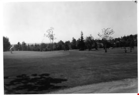
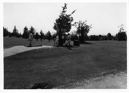
- Photograph of the greens at Kensington Pitch & Putt golf course, located on the 5800 block of Curtis Street. Two golfers are on the green in the foreground; one is lining up a shot. A small group of golfers is visible in the distance. The photograph is taken from across the green, facing northeast.
- Repository
- City of Burnaby Archives
- Date
- May 27, 1978
- Collection/Fonds
- Burnaby Public Library Contemporary Visual Archive Project
- Physical Description
- 1 photograph : b&w ; 12.5 x 17.5 cm
- Description Level
- Item
- Record No.
- 556-638
- Access Restriction
- No restrictions
- Reproduction Restriction
- Reproduce for fair dealing purposes only
- Accession Number
- 2017-57
- Scope and Content
- Photograph of the greens at Kensington Pitch & Putt golf course, located on the 5800 block of Curtis Street. Two golfers are on the green in the foreground; one is lining up a shot. A small group of golfers is visible in the distance. The photograph is taken from across the green, facing northeast.
- Media Type
- Photograph
- Photographer
- Surridge, Jack
- Notes
- Title taken from project information form
- Accompanied by a project information form and 1 photograph (b&w negative ; 9.5 x 12.5 cm)
- BPL no. 87
- Street Address
- 5889 Curtis Street
- 6159 Curtis Street
- Planning Study Area
- Parkcrest-Aubrey Area
Images

Kensington Pitch & Putt
https://search.heritageburnaby.ca/link/archivedescription93682
- Repository
- City of Burnaby Archives
- Date
- May 27, 1978
- Collection/Fonds
- Burnaby Public Library Contemporary Visual Archive Project
- Description Level
- Item
- Physical Description
- 1 photograph : b&w ; 12.5 x 17.5 cm
- Scope and Content
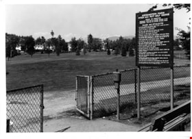
- Photograph of the Kensington Pitch & Putt Golf Course on the 5800 block of Curtis Street. The photograph shows a sign displaying the rules and etiquette for the golf course in the foreground, next to a chainlink fence. The photograph is taken facing northwest, and the mountains are visible in the d…
- Repository
- City of Burnaby Archives
- Date
- May 27, 1978
- Collection/Fonds
- Burnaby Public Library Contemporary Visual Archive Project
- Physical Description
- 1 photograph : b&w ; 12.5 x 17.5 cm
- Description Level
- Item
- Record No.
- 556-639
- Access Restriction
- No restrictions
- Reproduction Restriction
- Reproduce for fair dealing purposes only
- Accession Number
- 2017-57
- Scope and Content
- Photograph of the Kensington Pitch & Putt Golf Course on the 5800 block of Curtis Street. The photograph shows a sign displaying the rules and etiquette for the golf course in the foreground, next to a chainlink fence. The photograph is taken facing northwest, and the mountains are visible in the distance.
- Media Type
- Photograph
- Photographer
- Surridge, Jack
- Notes
- Title taken from project information form
- Accompanied by a project information form and 1 photograph (b&w negative ; 9.5 x 12.5 cm)
- BPL no. 88
- Street Address
- 5889 Curtis Street
- 6159 Curtis Street
- Planning Study Area
- Parkcrest-Aubrey Area
Images

Kensington Pitch & Putt
https://search.heritageburnaby.ca/link/archivedescription93683
- Repository
- City of Burnaby Archives
- Date
- May 27, 1978
- Collection/Fonds
- Burnaby Public Library Contemporary Visual Archive Project
- Description Level
- Item
- Physical Description
- 1 photograph : b&w ; 12.5 x 17.5 cm
- Scope and Content
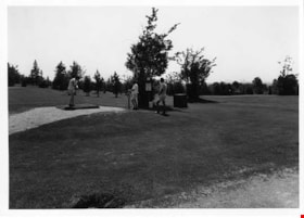
- Photograph of the Kensington Pitch & Putt Golf Course on the 5800 block of Curtis Street. Three golfers are on the green; one is lining up a shot on the teeing green. The photograph is taken facing southeast.
- Repository
- City of Burnaby Archives
- Date
- May 27, 1978
- Collection/Fonds
- Burnaby Public Library Contemporary Visual Archive Project
- Physical Description
- 1 photograph : b&w ; 12.5 x 17.5 cm
- Description Level
- Item
- Record No.
- 556-640
- Access Restriction
- No restrictions
- Reproduction Restriction
- Reproduce for fair dealing purposes only
- Accession Number
- 2017-57
- Scope and Content
- Photograph of the Kensington Pitch & Putt Golf Course on the 5800 block of Curtis Street. Three golfers are on the green; one is lining up a shot on the teeing green. The photograph is taken facing southeast.
- Media Type
- Photograph
- Photographer
- Surridge, Jack
- Notes
- Title taken from project information form
- Accompanied by a project information form and 1 photograph (b&w negative ; 9.5 x 12.5 cm)
- BPL no. 88
- Street Address
- 5889 Curtis Street
- 6159 Curtis Street
- Planning Study Area
- Parkcrest-Aubrey Area
Images
![Kensington Pitch & Putt, [2000] thumbnail](/media/hpo/_Data/_Archives_Images/_Unrestricted/535/535-3103.jpg?width=280)
Kensington Pitch & Putt
https://search.heritageburnaby.ca/link/archivedescription97999
- Repository
- City of Burnaby Archives
- Date
- [2000]
- Collection/Fonds
- Burnaby NewsLeader photograph collection
- Description Level
- Item
- Physical Description
- 1 photograph (tiff) : col.
- Scope and Content
- Photograph of Joaquin Ortega putting on a green at the Kensington Pitch & Putt course. The snow-covered mountains are visible in the background.
- Repository
- City of Burnaby Archives
- Date
- [2000]
- Collection/Fonds
- Burnaby NewsLeader photograph collection
- Physical Description
- 1 photograph (tiff) : col.
- Description Level
- Item
- Record No.
- 535-3103
- Access Restriction
- No restrictions
- Reproduction Restriction
- No restrictions
- Accession Number
- 2018-12
- Scope and Content
- Photograph of Joaquin Ortega putting on a green at the Kensington Pitch & Putt course. The snow-covered mountains are visible in the background.
- Media Type
- Photograph
- Photographer
- Bartel, Mario
- Notes
- Title based on caption
- Collected by editorial for use in a February 2000 issue of the Burnaby NewsLeader
- Caption from metadata: "A sure sign of Spring is the official opening of the Kensington Pitch & Putt golf course. Joaquin Ortega putts out on a beautiful sunny morning."
- Geographic Access
- Curtis Street
- Street Address
- 5889 Curtis Street
- Planning Study Area
- Parkcrest-Aubrey Area
Images
![Kensington Pitch & Putt, [2000] thumbnail](/media/hpo/_Data/_Archives_Images/_Unrestricted/535/535-3103.jpg)
Kool-Aid Stand
https://search.heritageburnaby.ca/link/archivedescription79690
- Repository
- City of Burnaby Archives
- Date
- September 7, 1976
- Collection/Fonds
- Burnaby Public Library Contemporary Visual Archive Project
- Description Level
- Item
- Physical Description
- 1 photograph : b&w ; 11 x 16 cm mounted on cardboard
- Scope and Content
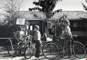
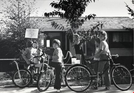
- Photograph shows children at a kool-aid stand set up outside 6490 Aubrey Street.
- Repository
- City of Burnaby Archives
- Date
- September 7, 1976
- Collection/Fonds
- Burnaby Public Library Contemporary Visual Archive Project
- Physical Description
- 1 photograph : b&w ; 11 x 16 cm mounted on cardboard
- Description Level
- Item
- Record No.
- 556-386
- Access Restriction
- No restrictions
- Reproduction Restriction
- Reproduce for fair dealing purposes only
- Accession Number
- 2013-13
- Scope and Content
- Photograph shows children at a kool-aid stand set up outside 6490 Aubrey Street.
- Media Type
- Photograph
- Photographer
- Born, A. J.
- Notes
- Scope note taken directly from BPL photograph description.
- 1 b&w copy negative : 10 x 12.5 cm accompanying
- Geographic Access
- Aubrey Street
- Street Address
- 6490 Aubrey Street
- Planning Study Area
- Parkcrest-Aubrey Area
Images

Municipality of Burnaby - Volume XV and Volume XVIII
https://search.heritageburnaby.ca/link/museumdescription8680
- Repository
- Burnaby Village Museum
- Date
- May 1927
- Collection/Fonds
- Burnaby Village Museum Map collection
- Description Level
- File
- Physical Description
- 4 plans on 4 sheets : col. lithographic prints ; 63.5 x 53.5 cm folded to 53 x 31.5 cm
- Scope and Content
- File consists of four pages of plans removed from a bound book containing a series of fire insurance plans of the Municipality of Burnaby. The first two pages are numbered "A" and "B" and are key plans from "GREATER VANCOUVER B.C. / VOLUME XV / Surveyed _ May 1927 / MUNICIPALITY OF / BURNABY", "PLA…
- Repository
- Burnaby Village Museum
- Collection/Fonds
- Burnaby Village Museum Map collection
- Description Level
- File
- Physical Description
- 4 plans on 4 sheets : col. lithographic prints ; 63.5 x 53.5 cm folded to 53 x 31.5 cm
- Material Details
- Scales [1:1200] and [1:6000]
- Scope and Content
- File consists of four pages of plans removed from a bound book containing a series of fire insurance plans of the Municipality of Burnaby. The first two pages are numbered "A" and "B" and are key plans from "GREATER VANCOUVER B.C. / VOLUME XV / Surveyed _ May 1927 / MUNICIPALITY OF / BURNABY", "PLAN DEPT. FIRE BRANCH _ B.C. INSURANCE UNDERWRITERS ASSN.". Key Plan "B" covers plans: 1505; 1506; 1512 to 1516; 1540 to 1544; 1550 to 1557 and District Lots: 129 to 132; 135 to 138; 205 to 208 and 215 to 218. Key Plan "A" covers plans: 1501 to 1504; 1507 to 1511; 1517 to 1525; 1531 to 1539; 1545 to 1550 and District Lots: 116 to 127 and 186 to 189. Plan "1806" is part of "GREATER VANCOUVER B.C. / VOLUME XVIII / Municipality of Burnaby / May, 1927" and covers District Lot 153. Plan "1807" is from "GREATER VANCOUVER B.C. / VOLUME XVIII / Municipality of Burnaby / May, 1927" and covers District Lots: 99,149 and 152.
- Responsibility
- British Columbia Underwriters' Association
- Accession Code
- HV972.111.2
- Access Restriction
- No restrictions
- Reproduction Restriction
- May be restricted by third party rights
- Date
- May 1927
- Media Type
- Cartographic Material
- Historic Neighbourhood
- Vancouver Heights (Historic Neighbourhood)
- Lochdale (Historic Neighbourhood)
- Capitol Hill (Historic Neighbourhood)
- Central Park (Historic Neighbourhood)
- Alta Vista (Historic Neighbourhood)
- Planning Study Area
- Burnaby Heights Area
- Sperling-Broadway Area
- Lochdale Area
- Parkcrest-Aubrey Area
- Westridge Area
- Willingdon Heights Area
- Capitol Hill Area
- Maywood Area
- Marlborough Area
- Scan Resolution
- 400
- Scan Date
- 2021-11-18
- Notes
- Title based on content of plans
- Scales are measured 1 inch = 100 feet and 1 inch = 500 feet
- See also BV987.1.70d for revised versions of plans
Zoomable Images


![New Canadian Entrepreneur of the Year Michael Low, [2002] thumbnail](/media/hpo/_Data/_Archives_Images/_Unrestricted/535/535-1994.jpg?width=280)
New Canadian Entrepreneur of the Year Michael Low
https://search.heritageburnaby.ca/link/archivedescription96311
- Repository
- City of Burnaby Archives
- Date
- [2002]
- Collection/Fonds
- Burnaby NewsLeader photograph collection
- Description Level
- Item
- Physical Description
- 1 photograph (tiff) : col.
- Scope and Content
- Photograph of Michael Low, President of Kingston College. Low stands in a computer lab filled with desktop computers.
- Repository
- City of Burnaby Archives
- Date
- [2002]
- Collection/Fonds
- Burnaby NewsLeader photograph collection
- Physical Description
- 1 photograph (tiff) : col.
- Description Level
- Item
- Record No.
- 535-1994
- Access Restriction
- No restrictions
- Reproduction Restriction
- No restrictions
- Accession Number
- 2018-12
- Scope and Content
- Photograph of Michael Low, President of Kingston College. Low stands in a computer lab filled with desktop computers.
- Media Type
- Photograph
- Photographer
- Bartel, Mario
- Notes
- Title based on caption
- Collected by editorial for use in a March 2002 issue of the Burnaby NewsLeader
- Caption from metadata: "Michael Low, the President of Kingston College, has just been named the New Canadian Entrepeneur of the Year."
- Geographic Access
- Holdom Avenue
- Planning Study Area
- Parkcrest-Aubrey Area
Images
![New Canadian Entrepreneur of the Year Michael Low, [2002] thumbnail](/media/hpo/_Data/_Archives_Images/_Unrestricted/535/535-1994.jpg)
Newsletter
https://search.heritageburnaby.ca/link/museumartifact90969
- Repository
- Burnaby Village Museum
- Accession Code
- BV020.33.16
- Description
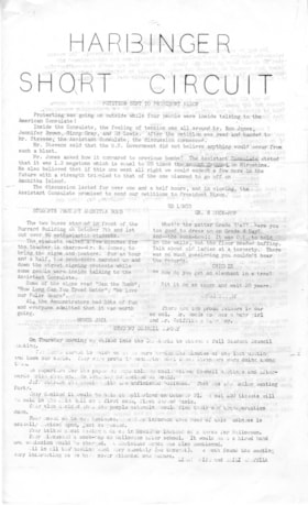
- Harbinger Short Circuit, school newsletter from Kensington Junior Secondary School - [196-]. Two pages of mimiographed legal sized cartridge paper; typewritten title on front page reads: HARBINGER / SHORT_CIRCUIT"; pages printed with black text on both sides.
- Object History
- From Kensington Junior Secondary School, Burnaby in the late 1960s.
- Category
- 08. Communication Artifacts
- Classification
- Documentary Artifacts - - Other Documents
- Object Term
- Serial
- Colour
- White
- Measurements
- 35.5 cm high x 25.5 cm
- Country Made
- Canada
- Province Made
- British Columbia
- Site/City Made
- Burnaby
- Subjects
- Documentary Artifacts - Newsletters
- Geographic Access
- Kensington Avenue
- Street Address
- 851 Kensington Avenue
- Historic Neighbourhood
- Capitol Hill (Historic Neighbourhood)
- Planning Study Area
- Parkcrest-Aubrey Area
Images

Newsletter
https://search.heritageburnaby.ca/link/museumartifact90970
- Repository
- Burnaby Village Museum
- Accession Code
- BV020.33.17
- Description
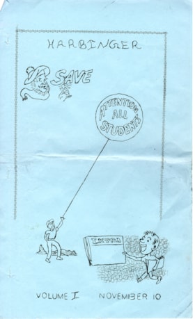
- Volume I, "Harbinger" school newsletter from Kensington Junior Secondary School - November 10 [196-]. Seven pages of mimiographed legal sized cartridge paper; printed both sides; front page printed on light blue cartridge paper with text at top "Harbinger and illustrations beneath; head of man wearing a tam and scarf and hand holding a coin with the word above "SAVE"; boy holding a circular balloon floating overhead with the words "ATTENTION / ALL / STUDENTS" and boy holding a newspaper with words "EXTRA" out in front while walking, text at bottom of front page reads:"VOLUME I NOVEMBER 10".
- Object History
- From Kensington Junior Secondary School, Burnaby in the late 1960s.
- Category
- 08. Communication Artifacts
- Classification
- Documentary Artifacts - - Other Documents
- Object Term
- Serial
- Colour
- Blue
- White
- Measurements
- 35.5 cm high x 25.5 cm
- Country Made
- Canada
- Province Made
- British Columbia
- Site/City Made
- Burnaby
- Subjects
- Documentary Artifacts - Newsletters
- Geographic Access
- Kensington Avenue
- Street Address
- 851 Kensington Avenue
- Historic Neighbourhood
- Capitol Hill (Historic Neighbourhood)
- Planning Study Area
- Parkcrest-Aubrey Area
Images

Newsletter
https://search.heritageburnaby.ca/link/museumartifact90971
- Repository
- Burnaby Village Museum
- Accession Code
- BV020.33.18
- Description
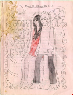
- Volume XII No. 3, "Harbinger" school newsletter from Kensington Junior Secondary School - March 14 [196-]. Seven pages of mimiographed letter sized cartridge paper; printed both sides; one page oversized paper; front page printed on light pink cartridge paper with text at top "March 14_Volume XII_No.3" and illustration of a side view of young man and woman standing together and bordered by flowing lines of spirals on either side and flower above, outlined graphic vertical text to the left of the couple reads "STUD/ENT/PRI/NTS" and "BEWARE THE IDES and exams!". Pink cartridge paper for back cover and white cartridge paper within. Front cover has been coloured in with red pencil crayon and pencil. Sixth page folds out and reveals a montage of photographs of students.
- Object History
- From Kensington Junior Secondary School, Burnaby in the late 1960s.
- Category
- 08. Communication Artifacts
- Classification
- Documentary Artifacts - - Other Documents
- Object Term
- Serial
- Marks/Labels
- Front and back covers have water stains.
- Colour
- Pink
- White
- Measurements
- 28 cm high x 21.5 cm wide
- Country Made
- Canada
- Province Made
- British Columbia
- Site/City Made
- Burnaby
- Subjects
- Documentary Artifacts - Newsletters
- Geographic Access
- Kensington Avenue
- Street Address
- 851 Kensington Avenue
- Historic Neighbourhood
- Capitol Hill (Historic Neighbourhood)
- Planning Study Area
- Parkcrest-Aubrey Area
Images

Newsletter
https://search.heritageburnaby.ca/link/museumartifact90972
- Repository
- Burnaby Village Museum
- Accession Code
- BV020.33.19
- Description
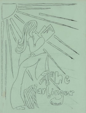
- Harbinger school newsletter from Kensington Junior Secondary School - [196-]. Six pages of mimiographed cartridge paper; five pages printed both sides; one page oversized paper; front cover page printed on light green cartridge paper with illustration of a woman with long hair and bell bottom pants holding a book and standing with her right foot on the letter "T" in the title "The / Harbinger" with rays of sunshine projected diagonally from the top left corner of the page. Yellow cartridge paper back cover and white cartridge paper within numbered 1 to 10. Paper between pages 6 and 7 folds out and reveals a montage of photographs of students.
- Object History
- From Kensington Junior Secondary School, Burnaby in the late 1960s.
- Category
- 08. Communication Artifacts
- Classification
- Documentary Artifacts - - Other Documents
- Object Term
- Serial
- Colour
- Green
- White
- Yellow
- Measurements
- 28 cm high x 21.5 cm wide
- Country Made
- Canada
- Province Made
- British Columbia
- Site/City Made
- Burnaby
- Subjects
- Documentary Artifacts - Newsletters
- Geographic Access
- Kensington Avenue
- Street Address
- 851 Kensington Avenue
- Historic Neighbourhood
- Capitol Hill (Historic Neighbourhood)
- Planning Study Area
- Parkcrest-Aubrey Area
Images

Newsletter
https://search.heritageburnaby.ca/link/museumartifact90973
- Repository
- Burnaby Village Museum
- Accession Code
- BV020.33.20
- Description
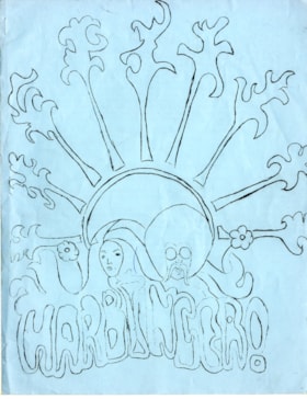
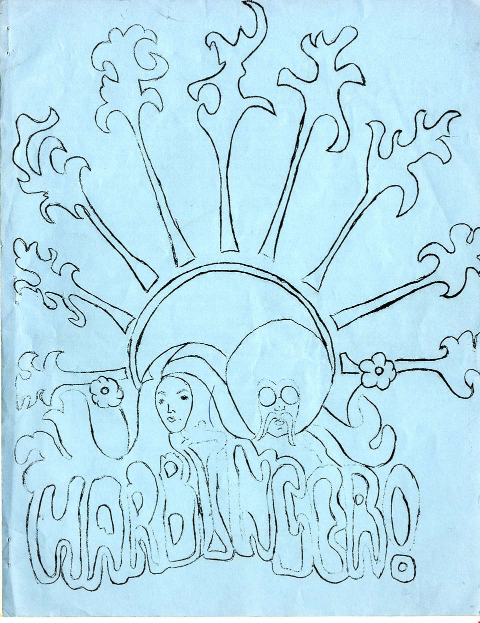
- Harbinger school newsletter from Kensington Junior Secondary School - March [196-]. Nine pages of mimiographed cartridge paper; seven pages printed both sides; one page oversized paper; front cover page printed on light blue cartridge paper with illustration of a man's head with an afro and mustache and woman's head with long flowing hair nestled in a stylized sunburst that radiates to the top of the page with the stylized word "HARBINGER!" at the bottom. Blue cartridge paper back cover and white cartridge paper within numbered 1 to 14. Paper between pages 8 and 9 folds out and reveals a montage of photographs of students. Water staining on front cover page.
- Object History
- From Kensington Junior Secondary School, Burnaby in the late 1960s.
- Category
- 08. Communication Artifacts
- Classification
- Documentary Artifacts - - Other Documents
- Object Term
- Serial
- Colour
- Blue
- White
- Measurements
- 28 cm high x 21.5 cm wide
- Country Made
- Canada
- Province Made
- British Columbia
- Site/City Made
- Burnaby
- Subjects
- Documentary Artifacts - Newsletters
- Geographic Access
- Kensington Avenue
- Street Address
- 851 Kensington Avenue
- Historic Neighbourhood
- Capitol Hill (Historic Neighbourhood)
- Planning Study Area
- Parkcrest-Aubrey Area
Images
Newsletter
https://search.heritageburnaby.ca/link/museumartifact90974
- Repository
- Burnaby Village Museum
- Accession Code
- BV020.33.21
- Description
- Kensington Junior Secondary School newsletter - June 11, 1968. Sixteen pages of mimiographed cartridge paper; fifteen pages printed both sides; one page oversized paper; pages numbered 1-29; pages 12-13 and 28-29 printed on light pink cartridge paper. Front cover page printed on light green cartridge paper with typewritten text in upper right corner "KENSINGTON JUNIOR SECONDARY SCHOOL / VOL. XIII : June 11, 1968 : No. 4" and illustration of a roman column to the left with words at base of column "LOOK .IN" and stylized vertical lettering to the right "STUDENT / PRINTS" and horizontal lettering "WITH (arrow to right) . JOKES . / . PICTURES. / . POEMS . / . STORIES . / FOR . THE / LITERARY / CONTEST . / and / CORNU- / COPIUS / CR [sic]". Front cover has been coloured with blue and red pen. Oversized page between pages 25 and 26 folds out and reveals a montage of photographs of students and teachers.
- Object History
- From Kensington Junior Secondary School, Burnaby in 1968.
- Category
- 08. Communication Artifacts
- Classification
- Documentary Artifacts - - Other Documents
- Object Term
- Serial
- Marks/Labels
- water/oil staining on cover page
- Colour
- Green
- Pink
- White
- Measurements
- 28 cm high x 21.5 cm wide
- Country Made
- Canada
- Province Made
- British Columbia
- Site/City Made
- Burnaby
- Subjects
- Documentary Artifacts - Newsletters
- Geographic Access
- Kensington Avenue
- Street Address
- 851 Kensington Avenue
- Historic Neighbourhood
- Capitol Hill (Historic Neighbourhood)
- Planning Study Area
- Parkcrest-Aubrey Area
Images

![North Burnaby, [1959] thumbnail](/media/hpo/_Data/_Archives_Images/_Unrestricted/001/106-001.jpg?width=280)
North Burnaby
https://search.heritageburnaby.ca/link/archivedescription34701
- Repository
- City of Burnaby Archives
- Date
- [1959]
- Collection/Fonds
- Burnaby Historical Society fonds
- Description Level
- Item
- Physical Description
- 1 photograph : b&w ; 16.6 x 20.5 cm
- Scope and Content
- Aerial photograph of North Burnaby and Burrard Inlet looking west.
- Repository
- City of Burnaby Archives
- Date
- [1959]
- Collection/Fonds
- Burnaby Historical Society fonds
- Subseries
- Photographs subseries
- Physical Description
- 1 photograph : b&w ; 16.6 x 20.5 cm
- Description Level
- Item
- Record No.
- 106-001
- Access Restriction
- No restrictions
- Reproduction Restriction
- Reproduce for fair dealing purposes only
- Accession Number
- BHS2007-04
- Scope and Content
- Aerial photograph of North Burnaby and Burrard Inlet looking west.
- Media Type
- Photograph
- Notes
- Title based on contents of photograph
- Historic Neighbourhood
- Vancouver Heights (Historic Neighbourhood)
- Capitol Hill (Historic Neighbourhood)
- Lochdale (Historic Neighbourhood)
- Planning Study Area
- Burnaby Heights Area
- Capitol Hill Area
- Westridge Area
- Willingdon Heights Area
- Brentwood Area
- Parkcrest-Aubrey Area
- Lochdale Area
Images
![North Burnaby, [1959] thumbnail](/media/hpo/_Data/_Archives_Images/_Unrestricted/001/106-001.jpg)

Parkcrest Elementary School
https://search.heritageburnaby.ca/link/archivedescription62669
- Repository
- City of Burnaby Archives
- Date
- August 27, 2009
- Collection/Fonds
- Community Heritage Commission Special Projects fonds
- Description Level
- Item
- Physical Description
- 1 photograph (tiff) : col. ; 600 ppi
- Scope and Content
- Photograph of Parkcrest Elementary School.
- Repository
- City of Burnaby Archives
- Date
- August 27, 2009
- Collection/Fonds
- Community Heritage Commission Special Projects fonds
- Physical Description
- 1 photograph (tiff) : col. ; 600 ppi
- Description Level
- Item
- Record No.
- 503-006
- Access Restriction
- No restrictions
- Reproduction Restriction
- No restrictions
- Accession Number
- 2009-10
- Scope and Content
- Photograph of Parkcrest Elementary School.
- Subjects
- Buildings - Schools
- Media Type
- Photograph
- Photographer
- Pasch, Rebecca
- Notes
- Title based on contents of photograph
- Geographic Access
- Halifax Street
- Street Address
- 6055 Halifax Street
- Planning Study Area
- Parkcrest-Aubrey Area
Images

![Parkcrest Elementary Walk to School program, [2000] thumbnail](/media/hpo/_Data/_Archives_Images/_Unrestricted/535/535-2391.jpg?width=280)
Parkcrest Elementary Walk to School program
https://search.heritageburnaby.ca/link/archivedescription96833
- Repository
- City of Burnaby Archives
- Date
- [2000]
- Collection/Fonds
- Burnaby NewsLeader photograph collection
- Description Level
- Item
- Physical Description
- 1 photograph (tiff) : col.
- Scope and Content
- Photograph of an unidentified Parkcrest Elementary student walking to school, next to one of several motivational posters from the school's Earth Week Walk to School Program placed along the sidewalk. The poster reads: "Way to go! Walk to school!" and other walking students are visible in the backg…
- Repository
- City of Burnaby Archives
- Date
- [2000]
- Collection/Fonds
- Burnaby NewsLeader photograph collection
- Physical Description
- 1 photograph (tiff) : col.
- Description Level
- Item
- Record No.
- 535-2391
- Access Restriction
- No restrictions
- Reproduction Restriction
- No restrictions
- Accession Number
- 2018-12
- Scope and Content
- Photograph of an unidentified Parkcrest Elementary student walking to school, next to one of several motivational posters from the school's Earth Week Walk to School Program placed along the sidewalk. The poster reads: "Way to go! Walk to school!" and other walking students are visible in the background.
- Subjects
- Persons - Students
- Media Type
- Photograph
- Photographer
- Bartel, Mario
- Notes
- Title based on caption
- Collected by editorial for use in an April 2000 issue of the Burnaby NewsLeader
- Caption from metadata: "Students at Parkcrest Elementary were greeted by posters along their walk to school Wednesday morning, as the school kicked off its Earth Week celebrations with a Walk to School program."
- Geographic Access
- Halifax Street
- Street Address
- 6055 Halifax Street
- Planning Study Area
- Parkcrest-Aubrey Area
Images
![Parkcrest Elementary Walk to School program, [2000] thumbnail](/media/hpo/_Data/_Archives_Images/_Unrestricted/535/535-2391.jpg)

Parkcrest Plaza
https://search.heritageburnaby.ca/link/archivedescription93653
- Repository
- City of Burnaby Archives
- Date
- October 23, 1977
- Collection/Fonds
- Burnaby Public Library Contemporary Visual Archive Project
- Description Level
- Item
- Physical Description
- 1 photograph : b&w ; 12.5 x 17.5 cm
- Scope and Content
- Photograph of the Parkcrest Plaza shopping centre at Sperling and Broadway. The photograph is taken from across the parking lot and lawn, facing west. Signs for the plaza's businesses include Fresh Foods and Bank of Nova Scotia, and homes and apartment buildings are in the distance.
- Repository
- City of Burnaby Archives
- Date
- October 23, 1977
- Collection/Fonds
- Burnaby Public Library Contemporary Visual Archive Project
- Physical Description
- 1 photograph : b&w ; 12.5 x 17.5 cm
- Description Level
- Item
- Record No.
- 556-610
- Access Restriction
- No restrictions
- Reproduction Restriction
- Reproduce for fair dealing purposes only
- Accession Number
- 2017-57
- Scope and Content
- Photograph of the Parkcrest Plaza shopping centre at Sperling and Broadway. The photograph is taken from across the parking lot and lawn, facing west. Signs for the plaza's businesses include Fresh Foods and Bank of Nova Scotia, and homes and apartment buildings are in the distance.
- Subjects
- Buildings - Commercial - Grocery Stores
- Buildings - Commercial - Malls
- Buildings - Commercial - Banks
- Buildings - Commercial - Stores
- Media Type
- Photograph
- Photographer
- Chapman, Fred
- Notes
- Title taken from project information form
- Accompanied by a project information form and 1 photograph (b&w negative ; 9.5 x 12.5 cm)
- BPL no. 60
- Geographic Access
- Sperling Avenue
- Broadway
- Street Address
- 5901 Sperling Avenue
- Planning Study Area
- Parkcrest-Aubrey Area
Images

![Parliament family home, the Half-House, [1928] thumbnail](/media/hpo/_Data/_Archives_Images/_Unrestricted/204/204-385.jpg?width=280)
Parliament family home, the Half-House
https://search.heritageburnaby.ca/link/archivedescription35527
- Repository
- City of Burnaby Archives
- Date
- [1928]
- Collection/Fonds
- Burnaby Historical Society fonds
- Description Level
- Item
- Physical Description
- 1 photograph : b&w ; 12.7 x 17.8 cm print
- Scope and Content
- Photograph of the Parliament family home, the famous landmark "half-house" on the 5770 block of Hastings Street, Capitol Hill. The photograph was taken looking north to Capitol Hill and Capitol Hill School is visible at the left.
- Repository
- City of Burnaby Archives
- Date
- [1928]
- Collection/Fonds
- Burnaby Historical Society fonds
- Subseries
- Pioneer Tales subseries
- Physical Description
- 1 photograph : b&w ; 12.7 x 17.8 cm print
- Description Level
- Item
- Record No.
- 204-385
- Access Restriction
- No restrictions
- Reproduction Restriction
- No known restrictions
- Accession Number
- BHS1988-03
- Scope and Content
- Photograph of the Parliament family home, the famous landmark "half-house" on the 5770 block of Hastings Street, Capitol Hill. The photograph was taken looking north to Capitol Hill and Capitol Hill School is visible at the left.
- Names
- Capitol Hill School
- Media Type
- Photograph
- Notes
- Title based on contents of photograph
- Annotations on top and bottom of photograph read, "The 'Half House'" / "Taken from 'The Tree'"
- Geographic Access
- Hastings Street
- Historic Neighbourhood
- Capitol Hill (Historic Neighbourhood)
- Planning Study Area
- Parkcrest-Aubrey Area
Images
![Parliament family home, the Half-House, [1928] thumbnail](/media/hpo/_Data/_Archives_Images/_Unrestricted/204/204-385.jpg)
Parliament Family Lot
https://search.heritageburnaby.ca/link/archivedescription35528
- Repository
- City of Burnaby Archives
- Date
- 1923 (date of original), copied 1986
- Collection/Fonds
- Burnaby Historical Society fonds
- Description Level
- Item
- Physical Description
- 1 photograph : b&w ; 12.7 x 17.8 cm print
- Scope and Content
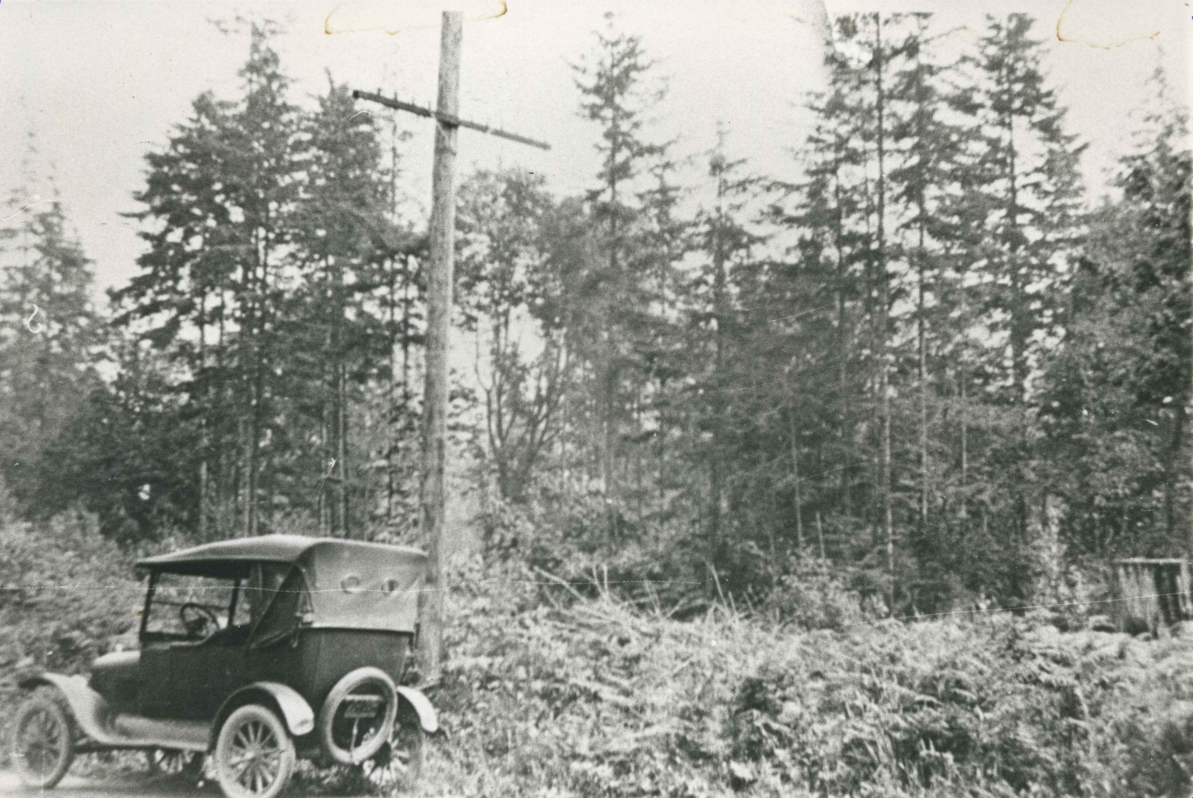
- Photograph of the lot on the 5770 block of Hastings Street for the Parliament family home before it was cleared. The home became known as the "Half-house" because it was only half completed when money ran out, so it was left half finished. Note the car in front.
- Repository
- City of Burnaby Archives
- Date
- 1923 (date of original), copied 1986
- Collection/Fonds
- Burnaby Historical Society fonds
- Subseries
- Pioneer Tales subseries
- Physical Description
- 1 photograph : b&w ; 12.7 x 17.8 cm print
- Description Level
- Item
- Record No.
- 204-386
- Access Restriction
- No restrictions
- Reproduction Restriction
- No known restrictions
- Accession Number
- BHS1988-03
- Scope and Content
- Photograph of the lot on the 5770 block of Hastings Street for the Parliament family home before it was cleared. The home became known as the "Half-house" because it was only half completed when money ran out, so it was left half finished. Note the car in front.
- Subjects
- Land Clearing
- Media Type
- Photograph
- Notes
- Title based on contents of photograph
- Geographic Access
- Hastings Street
- Historic Neighbourhood
- Capitol Hill (Historic Neighbourhood)
- Planning Study Area
- Parkcrest-Aubrey Area
Images
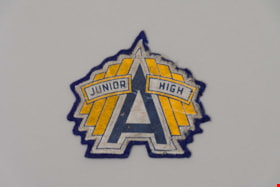
Patch
https://search.heritageburnaby.ca/link/museumartifact90315
- Repository
- Burnaby Village Museum
- Accession Code
- BV020.8.10
- Description
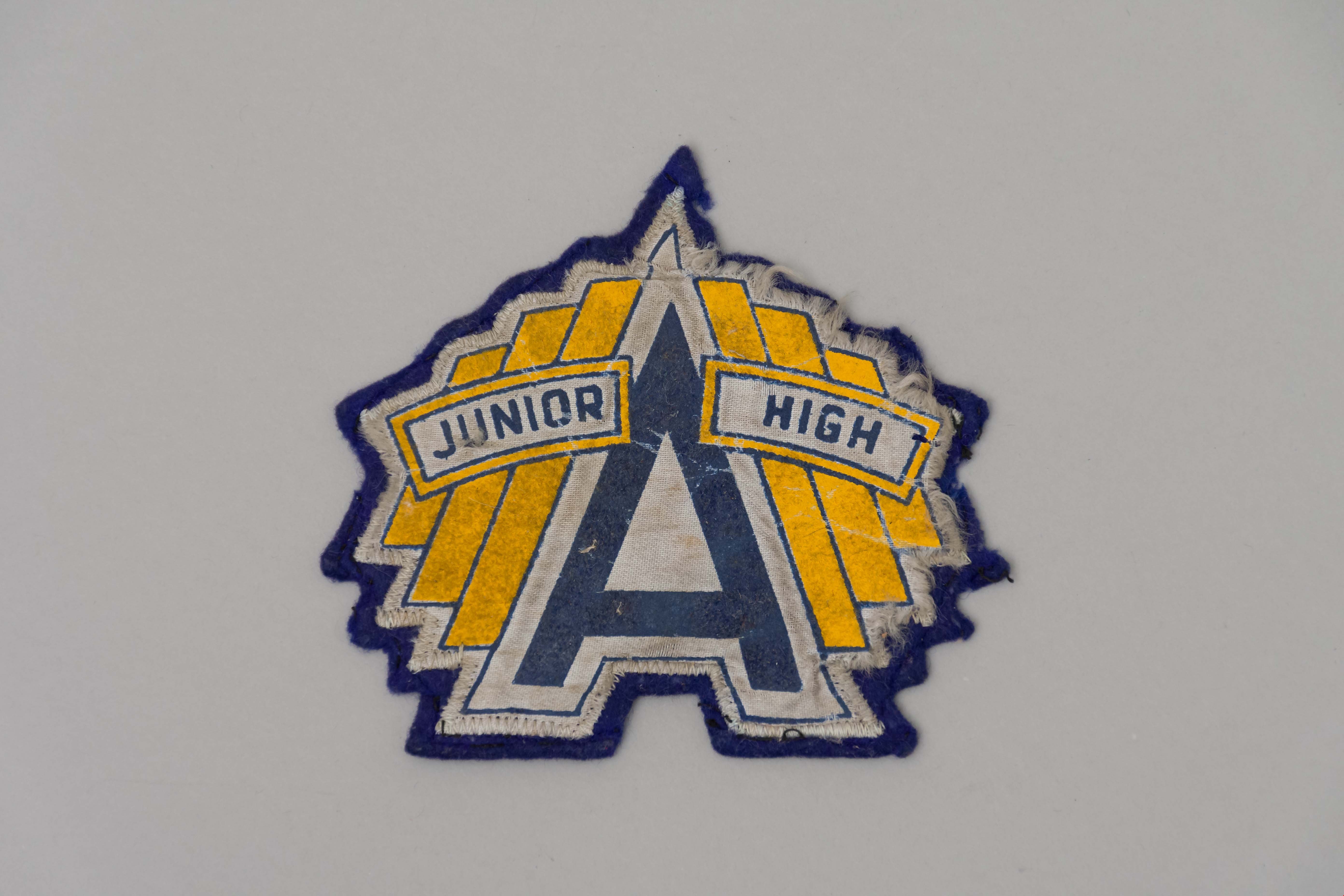
- A navy blue felt sew-on patch with the Alpha Junior High School logo. A large blue "A" is in the centre of the patch with a white outline. The words "Junior" and "High" are on either side of the "A" in blue with a yellow outline. Behind these two words are three yellow bars.
- Object History
- This patch belonged to the donor who attended Alpha Junior High School in the 1950s.
- Category
- 08. Communication Artifacts
- Classification
- Personal Symbols
- Object Term
- Patch, Insignia
- Marks/Labels
- A Junior High
- Colour
- Blue
- White
- Yellow
- Measurements
- 12 cm x 12cm
- Names
- Alpha Secondary School
- Historic Neighbourhood
- Capitol Hill (Historic Neighbourhood)
- Planning Study Area
- Parkcrest-Aubrey Area
Images