Narrow Results By
Subject
- Aerial Photographs 1
- Agriculture - Farms 2
- Animals - Cows 1
- Animals - Horses 2
- Buildings - Commercial - Stores 1
- Buildings - Heritage 9
- Buildings - Religious - Churches 2
- Buildings - Residences - Houses 2
- Buildings - Residential - Houses 17
- Celebrations 2
- Ceremonies - Weddings 1
- Clothing - Costumes 9
Person / Organization
- Baldwin, Susan 2
- Bateman, Marianne May 2
- Burnaby Central Secondary School 1
- Burnaby United Church 1
- Canadian Institute of Mining and Metallurgy 1
- Clarke, Mrs. H. 1
- Clayton, Sara Maureen Fleming 4
- Deer Lake United Church 2
- Douglas Road School 1
- Dowad, Kathleen "Kay" 1
- Dowad, Martha Elias Shaheen 1
- Dowad, Naomi "Mamie" David 1

Buckingham Elementary School
https://search.heritageburnaby.ca/link/landmark832
- Repository
- Burnaby Heritage Planning
- Geographic Access
- Buckingham Avenue
- Associated Dates
- 1962
- Heritage Value
- Buckingham Elementary School opened in 1962 with 86 pupils. The school was intended to take some of the pressure off of both Lakeview and Morley Elementary Schools which saw large volumes of enrolments throughout the 1950s. In 1964, two additional rooms were built onto the school and in 1969 a library, staffroom and medical room were added.
- Historic Neighbourhood
- Burnaby Lake (Historic Neighbourhood)
- Planning Study Area
- Morley-Buckingham Area
- Street Address
- 6066 Buckingham Avenue
- Street View URL
- Google Maps Street View
Images


Deer Lake Park
https://search.heritageburnaby.ca/link/landmark692
- Repository
- Burnaby Heritage Planning
- Associated Dates
- 1949
- Heritage Value
- As Burnaby developed into a more urban suburb of Vancouver and New Westminster the Deer Lake area retained much of its rural character. In 1949 Deer Lake park was established on the lake's eastern shore. The relocation of the Municipal Hall in the mid-1950s to the Deer Lake area began the vision of developing an administrative and cultural centre for Burnaby. The opportunity for developing this centre began with the opening of the Arts Centre, Century Gardens and the Burnaby Art Gallery in 1967. This was followed by the development of the Deer Lake Park as Burnaby's primary urban park.
- Historic Neighbourhood
- Burnaby Lake (Historic Neighbourhood)
- Planning Study Area
- Morley-Buckingham Area
- Street View URL
- Google Maps Street View
Images


Dr. William & Ruth Baldwin House
https://search.heritageburnaby.ca/link/landmark534
- Repository
- Burnaby Heritage Planning
- Description
- The Dr. William & Ruth Baldwin House is a two-storey modern post-and-beam structure, located on the southern shore of Deer Lake in Burnaby's Deer Lake Park. The site is steeply sloped, and the main entrance of the house is at the top of the slope facing onto Deer Lake Drive.
- Associated Dates
- 1965
- Formal Recognition
- Community Heritage Register
- Repository
- Burnaby Heritage Planning
- Geographic Access
- Deer Lake Drive
- Associated Dates
- 1965
- Formal Recognition
- Community Heritage Register
- Enactment Type
- Council Resolution
- Enactment Date
- 26/05/2003
- Description
- The Dr. William & Ruth Baldwin House is a two-storey modern post-and-beam structure, located on the southern shore of Deer Lake in Burnaby's Deer Lake Park. The site is steeply sloped, and the main entrance of the house is at the top of the slope facing onto Deer Lake Drive.
- Heritage Value
- The Baldwin House is valued as a prime example of Burnaby’s post-Second World War modern heritage and progressive architectural style, as well as for its personal connections to internationally-acclaimed architect, Arthur Erickson. Inspired by the modern domestic idiom established earlier in the twentieth century by Frank Lloyd Wright and Richard Neutra, Erickson conceived his architecture as responding directly to the site. A cohesive expression of simple orthogonal lines and ultimate transparency, this structure reduces the idea of post-and-beam West Coast modernism to its most refined elements. A fine example of the evolving talent of Erickson’s earlier work, this house is a landmark modern house in Burnaby and is unique in terms of siting and context. Having just won the 1963 competition for the new Simon Fraser University in Burnaby with his partner, Geoff Massey, and having built fewer than half a dozen homes previously, Erickson’s reputation was growing and his skill as a designer of modern buildings was in great demand. The same year that Erickson/Massey Architects designed SFU, Dr. William Baldwin and his wife, Ruth, personal friends of Erickson, commissioned him to design this house. Erickson was already familiar with the site; as a child he had spent time at this spot when his family visited friends who lived on Deer Lake. Both the Baldwin House and the university were completed in 1965. SFU became internationally famous; the Baldwin House was also considered an architectural success and was recognized in publications of the time. Only a single storey of this two-storey house is visible from the road, as it is built into the hillside in response to its steep site and proximity to Deer Lake. Like many other Erickson designs, this structure was conceived as a pavilion. Constructed of glass and wood, its transparency facilitates visual access to the lake’s edge, acting as an invitation, rather than a barrier, to the landscape. The house blends into the natural surroundings and the site includes other man-made landscape features such as a reflecting pool. As a reaction to the often grey quality of light in the region, Erickson exploits flat planes of water as a source of borrowed light. The refined and purposeful design, transparency, openness of plan and adjacency to the lake combine to give the house a floating appearance at the water's edge. The concept of a floating house set within an accompanying garden was inspired, in part, by the palaces and house boats of Dal Lake in Kashmir and the famed nearby Mughal Gardens. Although Erickson never visited Dal Lake, he travelled extensively throughout India, and specifically mentions the Kashmir reference in relation to this house. There is a rich complexity of other allusions worked into the fabric of the house, unified by a feeling for the conjunction of light, water and land at this special location. Widely renowned as Canada’s most brilliant modern architect, Erickson’s reputation is important to the development and growth of modern architecture in Canada and North America.
- Defining Elements
- The elements of the Baldwin House that define its character are those materials and details which respond to the location of the building and determine the relation between landscape and building, combining to create a single cohesive site. These include its: - close proximity to water - orthogonal plan and massing, with flat tar-and-gravel roof - stepped down massing orienting the house towards the water - post-and-beam construction, with the width of the beams matched to the width of the posts - wood and glass used as primary building materials - transparency and light achieved by the abundant use of glass - large undivided sheets of single glazing - butt glazed glass corners - abundant and generous balconies, which blur the transition from interior to exterior - horizontal flush cedar siding - use of salvaged brick for chimneys - use of chains as downspouts - built-in rooftop barbeque - built in furniture and fittings dating to the time of construction, such as original hardware, benches, bathroom vanities and kitchen cabinets - landscaped site including reflecting pool, plantings and a dock protruding into the lake
- Locality
- Deer Lake Park
- Historic Neighbourhood
- Burnaby Lake (Historic Neighbourhood)
- Planning Study Area
- Morley-Buckingham Area
- Function
- Primary Current--Single Dwelling
- Primary Historic--Single Dwelling
- Community
- Burnaby
- Cadastral Identifier
- P.I.D. No. 011-946-032 and P.I.D. No. 011-946-067
- Boundaries
- The Baldwin House is comprised of two municipally-owned lots located at 6543 and 6545 Deer Lake Drive, Burnaby.
- Area
- 6,070.20
- Contributing Resource
- Building
- Landscape Feature
- Ownership
- Public (local)
- Other Collection
- Canadian Architectural Archives, University of Calgary, Collection: Original Plans No. ERI 4A/76.13
- Documentation
- Heritage Site Files: PC77000 20. City of Burnaby Planning and Building Department, 4949 Canada Way, Burnaby, B.C., V5G 1M2
- Street Address
- 6543 Deer Lake Drive
Images


Montague & Marcia Moore Residence
https://search.heritageburnaby.ca/link/landmark499
- Repository
- Burnaby Heritage Planning
- Description
- The Montague and Marcia Moore Residence, situated on Sperling Avenue, is a one and one-half storey wood-frame house with Tudor Revival elements such as half-timbering and diamond-leaded windows. The landscaping includes a large hedge at the front of the property. It is located on a lakefront site w…
- Associated Dates
- 1943
- Street View URL
- Google Maps Street View
- Repository
- Burnaby Heritage Planning
- Geographic Access
- Sperling Avenue
- Associated Dates
- 1943
- Description
- The Montague and Marcia Moore Residence, situated on Sperling Avenue, is a one and one-half storey wood-frame house with Tudor Revival elements such as half-timbering and diamond-leaded windows. The landscaping includes a large hedge at the front of the property. It is located on a lakefront site within the scenic Deer Lake Park Heritage Precinct.
- Heritage Value
- Located within the historic Deer Lake Park neighbourhood, the Montague and Marcia Moore Residence is valued as an example of the late persistence of the historicist influence on domestic architecture, at a time when it was still considered the height of good taste for a house to be designed in a recognizable period revival style. This is reflected in the rustic Tudor Revival elements such as half-timbering, waney-edged boards in the gables, brick nogging, diamond-leaded windows, and bird houses in the main gable. The cobblestone chimney, the major focal point of the house, was constructed from river stones that were transported from Lynn Canyon. Meticulously retained in its original condition, this was the last home to be constructed by the Moore family before the Second World War construction supply rationing took effect. It was built by Danish contractor, Hans Jorgensen Hau (1878-1944), who had a flair for the construction of homes with a rustic character, and shares a number of design features with Hau’s own house at 5070 Canada Way.
- Defining Elements
- Key elements that define the heritage character of the Montague and Marcia Moore Residence include its: - location on a lakefront site, within the Deer Lake Park Heritage Precinct - residential form, scale and massing as expressed by its one and one-half storey height, rectangular plan and front gabled roof - wood-frame construction - Tudor Revival elements such as stucco and wood half-timbering, diamond-leaded casement windows, scroll-cut brackets, brick nogging on the front façade, bird houses in the main front gable, waney-edged boards at gable peaks, plank front door with strap hinges and a prominent external cobblestone chimney - associated landscape features such as a granite wall, and mature coniferous and deciduous trees
- Historic Neighbourhood
- Burnaby Lake (Historic Neighbourhood)
- Planning Study Area
- Morley-Buckingham Area
- Organization
- Canadian Institute of Mining and Metallurgy
- Builder
- Hans Jorgensen Hau
- Function
- Primary Historic--Single Dwelling
- Primary Current--Single Dwelling
- Community
- Deer Lake
- Cadastral Identifier
- P.I.D.006-082-696
- Boundaries
- The Montague and Marcia Moore Residence is comprised of a single residential lot located at 5165 Sperling Avenue, Burnaby.
- Area
- 4104
- Contributing Resource
- Building
- Ownership
- Public (local)
- Documentation
- City of Burnaby Planning and Building Department, Heritage Site Files
- Street Address
- 5165 Sperling Avenue
- Street View URL
- Google Maps Street View
Images


Moore House
https://search.heritageburnaby.ca/link/landmark497
- Repository
- Burnaby Heritage Planning
- Description
- The Moore House is a one-storey, side-gabled house with stepped roof planes and a split-level attached garage. The house faces east, and features distinct river rock porch columns and a large central tapered chimney. It is located within the Deer Lake Park Heritage Precinct, and is adjacent to a re…
- Associated Dates
- 1941
- Formal Recognition
- Community Heritage Register
- Other Names
- Ethel Moore Residence
- Street View URL
- Google Maps Street View
- Repository
- Burnaby Heritage Planning
- Other Names
- Ethel Moore Residence
- Geographic Access
- Sperling Avenue
- Associated Dates
- 1941
- Formal Recognition
- Community Heritage Register
- Enactment Type
- Council Resolution
- Enactment Date
- 26/05/2003
- Description
- The Moore House is a one-storey, side-gabled house with stepped roof planes and a split-level attached garage. The house faces east, and features distinct river rock porch columns and a large central tapered chimney. It is located within the Deer Lake Park Heritage Precinct, and is adjacent to a related house, the Rosalie (Moore) Barrett Residence, built the following year.
- Heritage Value
- The Moore House is significant for its relationship to first owner, Ethel Hutchings Moore (1884-1948), who purchased the property from Maud and Harriet Woodward, two of Deer Lake's first residents. Moore purchased the property with the hopes of introducing her children into the house construction business. This house, built in 1941, borrows its design from a 'California Desert House' built in Carmel a few years earlier. Rendered in traditional materials, this modern style merges comfortably with the rustic British Arts and Crafts tradition of most Deer Lake houses. Unusual for being built during wartime date, it was built at a time when domestic construction was severely curtailed due to shortages of labour and material. It is now owned by the City of Burnaby and is part of the Deer Lake Park Heritage Precinct. The Moore House is significant as a testament to Deer Lake's continued popularity as a residential neighbourhood in the 1940s. Although Burnaby was serviced by a number of transportation links at the time, the increasing availability of automobiles provided improved access to outlying suburbs. Rising real estate prices in Vancouver and New Westminster attracted residents to this neighbourhood because of its relative affordability, central location and beautiful scenery.
- Defining Elements
- Key elements that define the heritage character of the Moore House include its: - location within the Deer Lake Park Heritage Precinct - residential form, scale and massing as expressed by its one-storey height, linear plan, side gabled roof with multiple roof planes and split-level attached garage - wood-frame construction with stucco cladding - river rock porch columns and external tapered chimney - decorative embellishments including scroll-cut stickwork on the rear elevation and waney-edged boards in the gable peaks - wooden-sash casement windows with three-part, horizontal leading - associated landscaping features, including stone wall at the front of the property and coniferous and deciduous trees surrounding the property
- Historic Neighbourhood
- Burnaby Lake (Historic Neighbourhood)
- Planning Study Area
- Morley-Buckingham Area
- Function
- Primary Historic--Single Dwelling
- Primary Current--Single Dwelling
- Community
- Deer Lake
- Cadastral Identifier
- P.I.D. 011-454-521
- Boundaries
- The Moore House is comprised of a single residential lot located at 5145 Sperling Avenue, Burnaby.
- Area
- 993.39
- Contributing Resource
- Building
- Ownership
- Public (local)
- Documentation
- City of Burnaby Planning and Building Department, Heritage Site Files
- Street Address
- 5145 Sperling Avenue
- Street View URL
- Google Maps Street View
Images


Morley-Buckingham Neighbourhood
https://search.heritageburnaby.ca/link/landmark829
- Repository
- Burnaby Heritage Planning
- Associated Dates
- 1955-2008
- Heritage Value
- In the 1980 "Residential Neighbourhood Environment Study," the Morley-Buckingham Neighbourhood is described as "perhaps Burnaby's most prestigious residential area. The lots are larger than most other areas of the Municipality and this, along with the new expensive housing developed over the past 10 years, has created a very desirable residential neighbourhood...The older area of Buckingham lies at the lower edge of the slope and here the homes and streets are more uniform and aged between 20 and 25 years old...to the east of Canada Way lies...a cluster townhouse development."
- Historic Neighbourhood
- Burnaby Lake (Historic Neighbourhood)
- Planning Study Area
- Morley-Buckingham Area
Images


Rosalie (Moore) Barrett Residence
https://search.heritageburnaby.ca/link/landmark498
- Repository
- Burnaby Heritage Planning
- Description
- The Rosalie (Moore) Barrett Residence is a one-storey ranch-style bungalow with a cross-gabled roofline, located on Sperling Avenue. It is located within the Deer Lake Park Heritage Precinct, and is adjacent to a related house, the Ethel Moore Residence, built the previous year.
- Associated Dates
- 1942
- Street View URL
- Google Maps Street View
- Repository
- Burnaby Heritage Planning
- Geographic Access
- Sperling Avenue
- Associated Dates
- 1942
- Description
- The Rosalie (Moore) Barrett Residence is a one-storey ranch-style bungalow with a cross-gabled roofline, located on Sperling Avenue. It is located within the Deer Lake Park Heritage Precinct, and is adjacent to a related house, the Ethel Moore Residence, built the previous year.
- Heritage Value
- This house is significant for its connection with first owner, Rosalie Barrett, the daughter of Ethel Hutchings Moore, who lived in the adjacent house at 5145 Sperling Avenue. A spacious modernist bungalow, it was constructed in 1942, and was designed by Rosalie Moore herself. Moore intended to build several houses on this property, but further development was curtailed due to wartime restrictions on domestic construction. The Rosalie (Moore) Barrett Residence is a testament to Deer Lake's continued popularity as a residential neighbourhood in the 1940s. Although Burnaby was serviced by a number of transportation links at the time, the increasing availability of automobiles provided improved access to outlying suburbs. Rising real estate prices in Vancouver and New Westminster attracted residents to this neighbourhood because of its relative affordability, central location and beautiful scenery.
- Defining Elements
- Key elements that define the heritage character of the Rosalie (Moore) Barrett Residence include its: - location within the Deer Lake Park Heritage Precinct - residential form, scale and massing as expressed by its one-storey height, rambling linear plan and cross-gabled roof - wood-frame construction with stucco siding and waney-edged boards in the gable peaks - red brick on the front façade and rough-cut granite at the base of the house - Modernist design as exemplified by the asymmetrical, linear plan with low pitched roof - internal granite chimney - original windows, including wooden-sash casement windows in double and triple-assembly with four-part, horizontal leading - original front door with glass block sidelights - associated landscape features such as granite gateposts, foundation plantings and mature coniferous trees
- Historic Neighbourhood
- Burnaby Lake (Historic Neighbourhood)
- Planning Study Area
- Morley-Buckingham Area
- Function
- Primary Historic--Single Dwelling
- Primary Current--Single Dwelling
- Community
- Deer Lake
- Cadastral Identifier
- P.I.D.006-082-696
- Boundaries
- The Rosalie (Moore) Barrett Residence is comprised of a single residential lot located at 5155 Sperling Avenue, Burnaby.
- Area
- 11291.44
- Contributing Resource
- Building
- Ownership
- Public (local)
- Documentation
- City of Burnaby Planning and Building Department, Heritage Site Files
- Street Address
- 5155 Sperling Avenue
- Street View URL
- Google Maps Street View
Images


![5165 Sperling Avenue construction, [1941 or 1942] (date of original), copied 1991 thumbnail](/media/hpo/_Data/_Archives_Images/_Unrestricted/370/370-550.jpg?width=280)
5165 Sperling Avenue construction
https://search.heritageburnaby.ca/link/archivedescription37963
- Repository
- City of Burnaby Archives
- Date
- [1941 or 1942] (date of original), copied 1991
- Collection/Fonds
- Burnaby Historical Society fonds
- Description Level
- Item
- Physical Description
- 1 photograph : b&w ; 2.6 x 3.7 cm print on contact sheet 20.7 x 26.2 cm
- Scope and Content
- Photograph of the house of the Montague Moore family under construction at 5165 Sperling Avenue.
- Repository
- City of Burnaby Archives
- Date
- [1941 or 1942] (date of original), copied 1991
- Collection/Fonds
- Burnaby Historical Society fonds
- Subseries
- Burnaby Image Bank subseries
- Physical Description
- 1 photograph : b&w ; 2.6 x 3.7 cm print on contact sheet 20.7 x 26.2 cm
- Description Level
- Item
- Record No.
- 370-550
- Access Restriction
- No restrictions
- Reproduction Restriction
- No known restrictions
- Accession Number
- BHS1999-03
- Scope and Content
- Photograph of the house of the Montague Moore family under construction at 5165 Sperling Avenue.
- Media Type
- Photograph
- Notes
- Title based on contents of photograph
- 1 b&w copy negative accompanying
- Geographic Access
- Sperling Avenue
- Street Address
- 5165 Sperling Avenue
- Historic Neighbourhood
- Burnaby Lake (Historic Neighbourhood)
- Planning Study Area
- Morley-Buckingham Area
Images
![5165 Sperling Avenue construction, [1941 or 1942] (date of original), copied 1991 thumbnail](/media/hpo/_Data/_Archives_Images/_Unrestricted/370/370-550.jpg)
![5165 Sperling Avenue construction, [1941 or 1942] (date of original), copied 1991 thumbnail](/media/hpo/_Data/_Archives_Images/_Unrestricted/370/370-551.jpg?width=280)
5165 Sperling Avenue construction
https://search.heritageburnaby.ca/link/archivedescription37964
- Repository
- City of Burnaby Archives
- Date
- [1941 or 1942] (date of original), copied 1991
- Collection/Fonds
- Burnaby Historical Society fonds
- Description Level
- Item
- Physical Description
- 1 photograph : b&w ; 2.6 x 3.7 cm print on contact sheet 20.7 x 26.2 cm
- Scope and Content
- Photograph of the house of the Montague Moore family under construction at 5165 Sperling Avenue. Other houses on the street can be seen to the right, and the road can be seen in the foreground.
- Repository
- City of Burnaby Archives
- Date
- [1941 or 1942] (date of original), copied 1991
- Collection/Fonds
- Burnaby Historical Society fonds
- Subseries
- Burnaby Image Bank subseries
- Physical Description
- 1 photograph : b&w ; 2.6 x 3.7 cm print on contact sheet 20.7 x 26.2 cm
- Description Level
- Item
- Record No.
- 370-551
- Access Restriction
- No restrictions
- Reproduction Restriction
- No known restrictions
- Accession Number
- BHS1999-03
- Scope and Content
- Photograph of the house of the Montague Moore family under construction at 5165 Sperling Avenue. Other houses on the street can be seen to the right, and the road can be seen in the foreground.
- Media Type
- Photograph
- Notes
- Title based on contents of photograph
- 1 b&w copy negative accompanying
- Geographic Access
- Sperling Avenue
- Street Address
- 5165 Sperling Avenue
- Historic Neighbourhood
- Burnaby Lake (Historic Neighbourhood)
- Planning Study Area
- Morley-Buckingham Area
Images
![5165 Sperling Avenue construction, [1941 or 1942] (date of original), copied 1991 thumbnail](/media/hpo/_Data/_Archives_Images/_Unrestricted/370/370-551.jpg)
![6595 Deer Lake Drive, [1948] (date of original), copied 1991 thumbnail](/media/hpo/_Data/_Archives_Images/_Unrestricted/370/370-565.jpg?width=280)
6595 Deer Lake Drive
https://search.heritageburnaby.ca/link/archivedescription37978
- Repository
- City of Burnaby Archives
- Date
- [1948] (date of original), copied 1991
- Collection/Fonds
- Burnaby Historical Society fonds
- Description Level
- Item
- Physical Description
- 1 photograph : b&w ; 2.7 x 4.8 cm print on contact sheet 20.7 x 26.2 cm
- Scope and Content
- Photograph of a house at 6595 Deer Lake Drive. Deer Lake can be seen in the background
- Repository
- City of Burnaby Archives
- Date
- [1948] (date of original), copied 1991
- Collection/Fonds
- Burnaby Historical Society fonds
- Subseries
- Burnaby Image Bank subseries
- Physical Description
- 1 photograph : b&w ; 2.7 x 4.8 cm print on contact sheet 20.7 x 26.2 cm
- Description Level
- Item
- Record No.
- 370-565
- Access Restriction
- No restrictions
- Reproduction Restriction
- No known restrictions
- Accession Number
- BHS1999-03
- Scope and Content
- Photograph of a house at 6595 Deer Lake Drive. Deer Lake can be seen in the background
- Subjects
- Buildings - Residential - Houses
- Media Type
- Photograph
- Notes
- Title based on contents of photograph
- 1 b&w copy negative accompanying
- Geographic Access
- Deer Lake
- Deer Lake Drive
- Street Address
- 6595 Deer Lake Drive
- Historic Neighbourhood
- Burnaby Lake (Historic Neighbourhood)
- Planning Study Area
- Morley-Buckingham Area
Images
![6595 Deer Lake Drive, [1948] (date of original), copied 1991 thumbnail](/media/hpo/_Data/_Archives_Images/_Unrestricted/370/370-565.jpg)
Back yard of the Mervin Mawhinney house looking north west
https://search.heritageburnaby.ca/link/museumdescription5208
- Repository
- Burnaby Village Museum
- Date
- 1962
- Collection/Fonds
- Reverend Edward S. Gale fonds
- Description Level
- Item
- Physical Description
- 1 photograph : col. ; 10 x 15.2 cm print
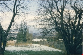
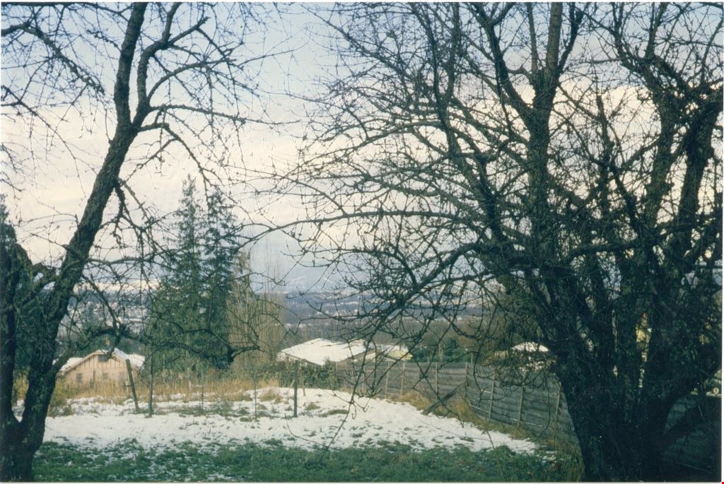
- Scope and Content
- Photograph of the back yard of the Mervin Mawhinney house looking north west. The ground is covered with snow. Two bare deciduous trees in foreground. The address of the house was 7661 Burris Street and was changed to 7667 Burris Street in 1984.
- Repository
- Burnaby Village Museum
- Collection/Fonds
- Reverend Edward S. Gale fonds
- Description Level
- Item
- Physical Description
- 1 photograph : col. ; 10 x 15.2 cm print
- Scope and Content
- Photograph of the back yard of the Mervin Mawhinney house looking north west. The ground is covered with snow. Two bare deciduous trees in foreground. The address of the house was 7661 Burris Street and was changed to 7667 Burris Street in 1984.
- Subjects
- Natural Phenomena - Snow
- Geographic Access
- Burris Street
- Street Address
- 7667 Burris Street
- Accession Code
- BV018.9.8
- Access Restriction
- No restrictions
- Reproduction Restriction
- May be restricted by third party rights
- Date
- 1962
- Media Type
- Photograph
- Planning Study Area
- Morley-Buckingham Area
- Scan Resolution
- 600
- Scan Date
- 07-05-2018
- Photographer
- Weller, Michael
- Notes
- Title based on contents of photograph
- "Dec. '62 / looking N. west" written in pen on verso.
Images

Baldwin House, Deer Lake Drive
https://search.heritageburnaby.ca/link/archivedescription37346
- Repository
- City of Burnaby Archives
- Date
- 1966
- Collection/Fonds
- Burnaby Historical Society fonds
- Description Level
- Item
- Physical Description
- 1 photograph ; b&w ; 19.5 x 25 cm print
- Scope and Content
- Photograph of four children (unidentified) playing in the water, in front of the Baldwin House. The Baldwin House was built in 1965 and was designed by architect Arthur Erickson for his friends Dr. William and Ruth Baldwin.
- Repository
- City of Burnaby Archives
- Date
- 1966
- Collection/Fonds
- Burnaby Historical Society fonds
- Subseries
- Baldwin family subseries
- Physical Description
- 1 photograph ; b&w ; 19.5 x 25 cm print
- Description Level
- Item
- Record No.
- 357-001
- Access Restriction
- No restrictions
- Reproduction Restriction
- Reproduce for fair dealing purposes only
- Accession Number
- BHS1998-03
- Scope and Content
- Photograph of four children (unidentified) playing in the water, in front of the Baldwin House. The Baldwin House was built in 1965 and was designed by architect Arthur Erickson for his friends Dr. William and Ruth Baldwin.
- Media Type
- Photograph
- Photographer
- King, Basil
- Notes
- Title based on contents of photograph
- Geographic Access
- Deer Lake Drive
- Deer Lake
- Street Address
- 6543 Deer Lake Drive
- Historic Neighbourhood
- Burnaby Lake (Historic Neighbourhood)
- Planning Study Area
- Morley-Buckingham Area
Images

Baldwin House Dining Room
https://search.heritageburnaby.ca/link/archivedescription37347
- Repository
- City of Burnaby Archives
- Date
- 1966
- Collection/Fonds
- Burnaby Historical Society fonds
- Description Level
- Item
- Physical Description
- 1 photograph : b&w ; 16 x 19.3 cm
- Scope and Content
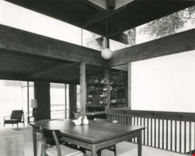
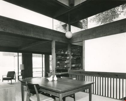
- Photograph of the dining room and interior of the Baldwin House at Deer Lake.
- Repository
- City of Burnaby Archives
- Date
- 1966
- Collection/Fonds
- Burnaby Historical Society fonds
- Subseries
- Baldwin family subseries
- Physical Description
- 1 photograph : b&w ; 16 x 19.3 cm
- Description Level
- Item
- Record No.
- 357-002
- Access Restriction
- No restrictions
- Reproduction Restriction
- Reproduce for fair dealing purposes only
- Accession Number
- BHS1998-03
- Scope and Content
- Photograph of the dining room and interior of the Baldwin House at Deer Lake.
- Subjects
- Buildings - Heritage
- Furniture
- Media Type
- Photograph
- Photographer
- King, Basil
- Notes
- Title based on contents of photograph.
- Geographic Access
- Deer Lake Drive
- Street Address
- 6543 Deer Lake Drive
- Historic Neighbourhood
- Burnaby Lake (Historic Neighbourhood)
- Planning Study Area
- Morley-Buckingham Area
Images
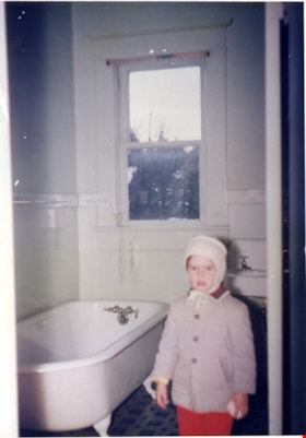
Bathroom of Mawhinney house
https://search.heritageburnaby.ca/link/museumdescription15568
- Repository
- Burnaby Village Museum
- Date
- 1962
- Collection/Fonds
- Reverend Edward S. Gale fonds
- Description Level
- Item
- Physical Description
- 1 photograph : col. negative ; 35 mm
- Scope and Content
- Photograph of the second floor bathroom inside of the Mervin Mawhinney house. Michael Weller's daughter is standing inside the bathroom with the bathtub to the left and the sink behind him. A pane glass window is on the wall above the bathtub. The address of the house was 7661 Burris Street and was…
- Repository
- Burnaby Village Museum
- Collection/Fonds
- Reverend Edward S. Gale fonds
- Description Level
- Item
- Physical Description
- 1 photograph : col. negative ; 35 mm
- Scope and Content
- Photograph of the second floor bathroom inside of the Mervin Mawhinney house. Michael Weller's daughter is standing inside the bathroom with the bathtub to the left and the sink behind him. A pane glass window is on the wall above the bathtub. The address of the house was 7661 Burris Street and was changed to 7667 Burris Street in 1984.
- Geographic Access
- Burris Street
- Street Address
- 7667 Burris Street
- Accession Code
- BV018.9.34
- Access Restriction
- No restrictions
- Reproduction Restriction
- May be restricted by third party rights
- Date
- 1962
- Media Type
- Photograph
- Planning Study Area
- Morley-Buckingham Area
- Scan Resolution
- 600
- Scan Date
- April 15, 2021
- Scale
- 100
- Photographer
- Weller, Michael
- Notes
- Title based on contents of photograph
- 1 col. print 12.5 x 9 cm accompanying
Images

![Blacksmith on Lubbock Farm, [194-] (date of original), copied 1986 thumbnail](/media/hpo/_Data/_Archives_Images/_Unrestricted/204/204-724.jpg?width=280)
Blacksmith on Lubbock Farm
https://search.heritageburnaby.ca/link/archivedescription35865
- Repository
- City of Burnaby Archives
- Date
- [194-] (date of original), copied 1986
- Collection/Fonds
- Burnaby Historical Society fonds
- Description Level
- Item
- Physical Description
- 1 photograph : b&w ; 12.7 x 17.8 cm print
- Scope and Content
- Photograph of John Lubbock working as the farm blacksmith on the Lubbock farm.
- Repository
- City of Burnaby Archives
- Date
- [194-] (date of original), copied 1986
- Collection/Fonds
- Burnaby Historical Society fonds
- Subseries
- Pioneer Tales subseries
- Physical Description
- 1 photograph : b&w ; 12.7 x 17.8 cm print
- Description Level
- Item
- Record No.
- 204-724
- Access Restriction
- No restrictions
- Reproduction Restriction
- Reproduce for fair dealing purposes only
- Accession Number
- BHS1988-03
- Scope and Content
- Photograph of John Lubbock working as the farm blacksmith on the Lubbock farm.
- Subjects
- Occupations - Blacksmiths
- Names
- Lubbock, John
- Media Type
- Photograph
- Notes
- Title based on contents of photograph.
- A note with this photograph indicated the old address of the farm was 1 Arbor Lane.
- Geographic Access
- Grandview Highway
- Canada Way
- Burris Street
- Street Address
- 7803 Burris Street
- Historic Neighbourhood
- Burnaby Lake (Historic Neighbourhood)
- Planning Study Area
- Morley-Buckingham Area
Images
![Blacksmith on Lubbock Farm, [194-] (date of original), copied 1986 thumbnail](/media/hpo/_Data/_Archives_Images/_Unrestricted/204/204-724.jpg)
![Blythe Eagles outside his home, [between 1955 and 1960] (date of original), copied 1996 thumbnail](/media/Hpo/_Data/_Archives_Images/_Unrestricted/205/245-002.jpg?width=280)
Blythe Eagles outside his home
https://search.heritageburnaby.ca/link/archivedescription51540
- Repository
- City of Burnaby Archives
- Date
- [between 1955 and 1960] (date of original), copied 1996
- Collection/Fonds
- Burnaby Historical Society fonds
- Description Level
- Item
- Physical Description
- 1 photograph : b&w copy negative ; 4 x 5.5 cm
- Scope and Content
- Photograph of Blythe Eagles standing in front of the Eagles' estate at Deer Lake.
- Repository
- City of Burnaby Archives
- Date
- [between 1955 and 1960] (date of original), copied 1996
- Collection/Fonds
- Burnaby Historical Society fonds
- Subseries
- Eagles family subseries
- Physical Description
- 1 photograph : b&w copy negative ; 4 x 5.5 cm
- Description Level
- Item
- Record No.
- 245-002
- Access Restriction
- No restrictions
- Reproduction Restriction
- Reproduce for fair dealing purposes only
- Accession Number
- BHS1990-11
- Scope and Content
- Photograph of Blythe Eagles standing in front of the Eagles' estate at Deer Lake.
- Names
- Eagles, Dr. Blythe
- Media Type
- Photograph
- Notes
- Title based on contents of photograph
- 1 b&w ; 12.7 x 17.7 cm print accompanying
- Geographic Access
- Sperling Avenue
- Street Address
- 5655 Sperling Avenue
- Historic Neighbourhood
- Burnaby Lake (Historic Neighbourhood)
- Planning Study Area
- Morley-Buckingham Area
Images
![Blythe Eagles outside his home, [between 1955 and 1960] (date of original), copied 1996 thumbnail](/media/Hpo/_Data/_Archives_Images/_Unrestricted/205/245-002.jpg)
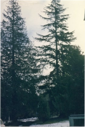
Cedar and hemlock trees
https://search.heritageburnaby.ca/link/museumdescription5214
- Repository
- Burnaby Village Museum
- Date
- Dec. 1962
- Collection/Fonds
- Reverend Edward S. Gale fonds
- Description Level
- Item
- Physical Description
- 1 photograph : col. ; 15.2 x 10.1 cm print
- Scope and Content
- Photograph of two large coniferous trees in the yard of the Mervin Mawhinney house. Some snowy ground in foreground. Overcast sky in background. The address of the house was 7661 Burris Street and was changed to 7667 Burris Street in 1984.
- Repository
- Burnaby Village Museum
- Collection/Fonds
- Reverend Edward S. Gale fonds
- Description Level
- Item
- Physical Description
- 1 photograph : col. ; 15.2 x 10.1 cm print
- Scope and Content
- Photograph of two large coniferous trees in the yard of the Mervin Mawhinney house. Some snowy ground in foreground. Overcast sky in background. The address of the house was 7661 Burris Street and was changed to 7667 Burris Street in 1984.
- Geographic Access
- Burris Street
- Street Address
- 7667 Burris Street
- Accession Code
- BV018.9.14
- Access Restriction
- No restrictions
- Reproduction Restriction
- May be restricted by third party rights
- Date
- Dec. 1962
- Media Type
- Photograph
- Planning Study Area
- Morley-Buckingham Area
- Scan Resolution
- 600
- Scan Date
- 07-05-2018
- Photographer
- Weller, Michael
- Notes
- Title based on contents of photograph
- "Dec. '62 / large cedar + hemlock at entrance" written in pen on verso.
Images

![Comedy show, [1940] thumbnail](/media/hpo/_Data/_Archives_Images/_Unrestricted/001/009-011.jpg?width=280)
Comedy show
https://search.heritageburnaby.ca/link/archivedescription34076
- Repository
- City of Burnaby Archives
- Date
- [1940]
- Collection/Fonds
- Burnaby Historical Society fonds
- Description Level
- Item
- Physical Description
- 1 photograph : b&w ; 8.2 x 8.5 cm
- Scope and Content
- Photograph of two men dressed as women in a Valleyview Community Centre comedy show.
- Repository
- City of Burnaby Archives
- Date
- [1940]
- Collection/Fonds
- Burnaby Historical Society fonds
- Subseries
- Photographs subseries
- Physical Description
- 1 photograph : b&w ; 8.2 x 8.5 cm
- Description Level
- Item
- Record No.
- 009-011
- Access Restriction
- No restrictions
- Reproduction Restriction
- No known restrictions
- Accession Number
- BHS2007-04
- Scope and Content
- Photograph of two men dressed as women in a Valleyview Community Centre comedy show.
- Media Type
- Photograph
- Notes
- Title based on contents of photograph
- Geographic Access
- Canada Way
- Street Address
- 4949 Canada Way
- Historic Neighbourhood
- Burnaby Lake (Historic Neighbourhood)
- Planning Study Area
- Morley-Buckingham Area
Images
![Comedy show, [1940] thumbnail](/media/hpo/_Data/_Archives_Images/_Unrestricted/001/009-011.jpg)
![Comedy show, [1940] thumbnail](/media/hpo/_Data/_Archives_Images/_Unrestricted/001/009-012.jpg?width=280)
Comedy show
https://search.heritageburnaby.ca/link/archivedescription34077
- Repository
- City of Burnaby Archives
- Date
- [1940]
- Collection/Fonds
- Burnaby Historical Society fonds
- Description Level
- Item
- Physical Description
- 1 photograph : b&w ; 8.2 x 8.2 cm
- Scope and Content
- Photograph of three men dressed as women in a Valleyview Community Centre comedy show. An audience is looking on from beside the stage.
- Repository
- City of Burnaby Archives
- Date
- [1940]
- Collection/Fonds
- Burnaby Historical Society fonds
- Subseries
- Photographs subseries
- Physical Description
- 1 photograph : b&w ; 8.2 x 8.2 cm
- Description Level
- Item
- Record No.
- 009-012
- Access Restriction
- No restrictions
- Reproduction Restriction
- No known restrictions
- Accession Number
- BHS2007-04
- Scope and Content
- Photograph of three men dressed as women in a Valleyview Community Centre comedy show. An audience is looking on from beside the stage.
- Media Type
- Photograph
- Notes
- Title based on contents of photograph
- Geographic Access
- Canada Way
- Street Address
- 4949 Canada Way
- Historic Neighbourhood
- Burnaby Lake (Historic Neighbourhood)
- Planning Study Area
- Morley-Buckingham Area
Images
![Comedy show, [1940] thumbnail](/media/hpo/_Data/_Archives_Images/_Unrestricted/001/009-012.jpg)
![Comedy show, [1940] thumbnail](/media/hpo/_Data/_Archives_Images/_Unrestricted/001/009-013.jpg?width=280)
Comedy show
https://search.heritageburnaby.ca/link/archivedescription34078
- Repository
- City of Burnaby Archives
- Date
- [1940]
- Collection/Fonds
- Burnaby Historical Society fonds
- Description Level
- Item
- Physical Description
- 1 photograph : b&w ; 8.2 x 8.3 cm
- Scope and Content
- Photograph of a man dressed as a woman in a Valleyview Community Centre comedy show.
- Repository
- City of Burnaby Archives
- Date
- [1940]
- Collection/Fonds
- Burnaby Historical Society fonds
- Subseries
- Photographs subseries
- Physical Description
- 1 photograph : b&w ; 8.2 x 8.3 cm
- Description Level
- Item
- Record No.
- 009-013
- Access Restriction
- No restrictions
- Reproduction Restriction
- No known restrictions
- Accession Number
- BHS2007-04
- Scope and Content
- Photograph of a man dressed as a woman in a Valleyview Community Centre comedy show.
- Media Type
- Photograph
- Notes
- Title based on contents of photograph
- Geographic Access
- Canada Way
- Street Address
- 4949 Canada Way
- Historic Neighbourhood
- Burnaby Lake (Historic Neighbourhood)
- Planning Study Area
- Morley-Buckingham Area
Images
![Comedy show, [1940] thumbnail](/media/hpo/_Data/_Archives_Images/_Unrestricted/001/009-013.jpg)