Narrow Results By
Subject
- Advertising Medium - Signs and Signboards 5
- Agriculture 2
- Animals - Bears 1
- Animals - Livestock 1
- Animals - Poultry 1
- Buildings - Commercial 1
- Buildings - Commercial - Grocery Stores 2
- Buildings - Residences - Houses 1
- Buildings - Residential 1
- Buildings - Residential - Houses 2
- Buildings - Residential - Seniors Housing 2
- Buildings - Schools 1

Hastings Grove Neighbourhood
https://search.heritageburnaby.ca/link/landmark746
- Repository
- Burnaby Heritage Planning
- Associated Dates
- 1905-1924
- Heritage Value
- During the height of the real estate boom between 1909 and 1913, Vancouver developer Frederick Munson plotted the subdivision of more than 150 acres of land on Curtis Street east of Sperling Avenue, on the newly logged slopes of remote Burnaby Mountain. Burnaby opened up Curtis Street to facilitate access to Hastings Grove and Munson agreed to pay one-third of the cost but never did. He also paid only $1000.00 down on the agreed price of the land. When he failed to make further payments, the mortgage holders foreclosed and re-sold the properties. People who had bought lots from Munson lost not only the land they though they owned, but also the money they had paid for it. Hastings Grove was a disaster. The converted automobile - which served as the bus - stopped running. The few houses and most of the lots reverted to the Municipality because of non-payment of taxes and are now part of Burnaby Mountain Park. The only remaining building is the old Hastings Grove Store which still stands as an apartment building.
- Historic Neighbourhood
- Lochdale (Historic Neighbourhood)
- Planning Study Area
- Lochdale Area
Images


Lochdale Neighbourhood
https://search.heritageburnaby.ca/link/landmark743
- Repository
- Burnaby Heritage Planning
- Associated Dates
- 1905-1924
- Heritage Value
- "Picturesquely situated on the south-westerly slope of the highest hill on the Burrard Peninsula is a district that in many ways resembles the early pioneer settlements…its centre is at the intersection of east Hastings Street and Sperling Avenue. Only a few years ago a dense forest covered this area and the settlers were few and some distance apart. After the war working men began to enter the Lochdale woods in quest of cheap home-sites. Today there are more than 400 residents in the district who combine to make a happy contented industrious community living on the edge of a big city yet enjoying the life offered by the country...The Community Hall is the centre of all social activities. Dances, concerts and other forms of entertainment are all there...Curtis Street runs from Sperling Avenue up to the hill, locally known as Hastings Grove. From the top on a clear day there is a view for miles around." ~ From the Sunday Province, March 8, 1925.
- Historic Neighbourhood
- Lochdale (Historic Neighbourhood)
- Planning Study Area
- Lochdale Area
Images


Lochdale Neighbourhood
https://search.heritageburnaby.ca/link/landmark790
- Repository
- Burnaby Heritage Planning
- Associated Dates
- 1955-2008
- Heritage Value
- Despite the rapid growth witnessed in Burnaby in the post-war years, the Lochdale Neighbourhood was characterised as a close-knit primarily residential community. Although a commercial zone developed along Sperling and Hastings, single-family, duplex and multi-family homes were the primary buildings in the area. Basement suites and student accommodation also flourished in this neighbourhood after the creation of Simon Fraser University on Burnaby Mountain.
- Historic Neighbourhood
- Lochdale (Historic Neighbourhood)
- Planning Study Area
- Lochdale Area
Images


Shell Oil Company
https://search.heritageburnaby.ca/link/landmark675
- Repository
- Burnaby Heritage Planning
- Geographic Access
- Kensington Avenue
- Associated Dates
- ca. 1930-1993
- Heritage Value
- After considering several sites in the Greater Vancouver area, the Shell Oil Company chose 70 acres in North Burnaby with frontage of one third of a mile on Burrard Inlet. Shell proposed to build a four-million dollar plant that would employ up to 2000 - providing some relief in the middle of Burnaby's economic crisis of the Depression years. The site became known as the Shellburn Refinery and was in operation until 1993.
- Historic Neighbourhood
- Lochdale (Historic Neighbourhood)
- Planning Study Area
- Westridge Area
Images


Sperling-Broadway Neighbourhood
https://search.heritageburnaby.ca/link/landmark789
- Repository
- Burnaby Heritage Planning
- Associated Dates
- 1955-2008
- Heritage Value
- By the 1970s, the Sperling-Broadway Neighbourhood was characterised as one of the Municipality's fastest growing residential areas. In 1980, it was estimated that slightly less than half of the homes were single-family residences, while the remaining development was taking the form of townhouse and high-rise apartments. The emphasis shifted back to single family housing during the construction of planned subdivisions such as the Camrose subdivision in the 1980s and the area remains primarily residential in nature. The neighbourhood is well-served by park facilities and is also home to the Burnaby Mountain Golf Course.
- Historic Neighbourhood
- Lochdale (Historic Neighbourhood)
- Planning Study Area
- Sperling-Broadway Area
Images


Westridge Neighbourhood
https://search.heritageburnaby.ca/link/landmark791
- Repository
- Burnaby Heritage Planning
- Associated Dates
- 1955-2008
- Heritage Value
- The Westridge Neighbourhood is effectively separated into two areas by Inlet Drive. To the west of the highway lies a typical 1950s subdivision of single-family homes, while to the east is a newer (1970s) subdivision featuring larger lots and some low-rise units. In the 1980 Residential Neighbourhood Environment Study, Westridge was characterised as a stable community with little need for direct Municipal involvement in growth and development.
- Historic Neighbourhood
- Lochdale (Historic Neighbourhood)
- Planning Study Area
- Westridge Area
Images

![7342 Curtis Street, [1981] thumbnail](/media/hpo/_Data/_Archives_Images/_Unrestricted/371/382-002.jpg?width=280)
7342 Curtis Street
https://search.heritageburnaby.ca/link/archivedescription38276
- Repository
- City of Burnaby Archives
- Date
- [1981]
- Collection/Fonds
- Burnaby Historical Society fonds
- Description Level
- Item
- Physical Description
- 1 photograph : b&w ; 9 x 12.5 cm
- Scope and Content
- Photograph of the house located at 7342 Curtis Street.
- Repository
- City of Burnaby Archives
- Date
- [1981]
- Collection/Fonds
- Burnaby Historical Society fonds
- Subseries
- Photographs subseries
- Physical Description
- 1 photograph : b&w ; 9 x 12.5 cm
- Description Level
- Item
- Record No.
- 382-002
- Access Restriction
- No restrictions
- Reproduction Restriction
- Reproduce for fair dealing purposes only
- Accession Number
- BHS1999-12
- Scope and Content
- Photograph of the house located at 7342 Curtis Street.
- Subjects
- Buildings - Residential - Houses
- Media Type
- Photograph
- Notes
- Title based on contents of photograph
- Geographic Access
- Curtis Street
- Street Address
- 7342 Curtis Street
- Historic Neighbourhood
- Lochdale (Historic Neighbourhood)
- Planning Study Area
- Lochdale Area
Images
![7342 Curtis Street, [1981] thumbnail](/media/hpo/_Data/_Archives_Images/_Unrestricted/371/382-002.jpg)
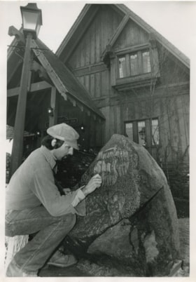
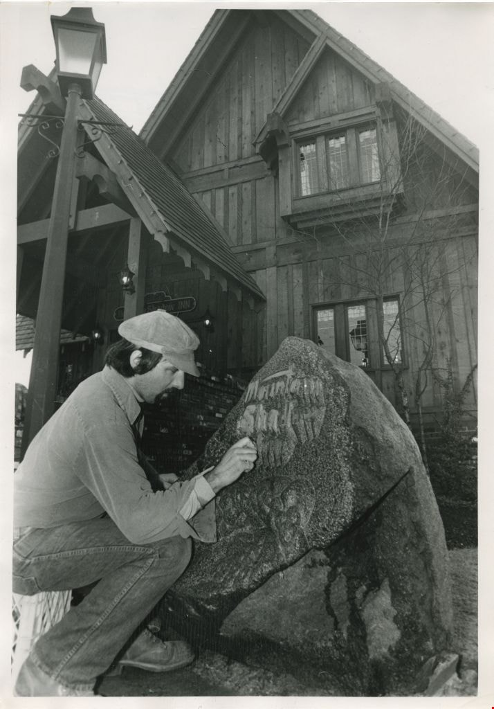
A man outside the Mountain Shadow Pub
https://search.heritageburnaby.ca/link/archivedescription58922
- Repository
- City of Burnaby Archives
- Date
- ca.1980
- Collection/Fonds
- Columbian Newspaper collection
- Description Level
- Item
- Physical Description
- 1 photograph : b&w ; 20.5 x 18 cm
- Scope and Content
- Photograph of a man outside the Mountain Shadow Pub that was located at the base of Burnaby Mountain. He appears to be rewriting the name of the pub on a rock.
- Repository
- City of Burnaby Archives
- Date
- ca.1980
- Collection/Fonds
- Columbian Newspaper collection
- Physical Description
- 1 photograph : b&w ; 20.5 x 18 cm
- Description Level
- Item
- Record No.
- 480-1373
- Access Restriction
- No restrictions
- Reproduction Restriction
- Reproduce for fair dealing purposes only
- Accession Number
- 2009-01
- Scope and Content
- Photograph of a man outside the Mountain Shadow Pub that was located at the base of Burnaby Mountain. He appears to be rewriting the name of the pub on a rock.
- Subjects
- Buildings - Commercial
- Media Type
- Photograph
- Photographer
- Hodge, Craig
- Notes
- Title based on contents of photograph
- Photographer's stamp on verso
- Note on verso reads: "page A-3 / Burnaby Today / PMT 110%"
- Geographic Access
- Burnaby Mountain Conservation Area
- Historic Neighbourhood
- Lochdale (Historic Neighbourhood)
- Planning Study Area
- Burnaby Mountain Area
Images

Barnet Wagon Road
https://search.heritageburnaby.ca/link/archivedescription38306
- Repository
- City of Burnaby Archives
- Date
- June 1903 (date of original), copied ca. 1990
- Collection/Fonds
- Burnaby Historical Society fonds
- Description Level
- Item
- Physical Description
- 1 photograph : b&w ; 10 x 15 cm print
- Scope and Content
- Photograph of the Barnet Wagon Road looking west from Sperling Avenue.
- Repository
- City of Burnaby Archives
- Date
- June 1903 (date of original), copied ca. 1990
- Collection/Fonds
- Burnaby Historical Society fonds
- Subseries
- Photographs subseries
- Physical Description
- 1 photograph : b&w ; 10 x 15 cm print
- Description Level
- Item
- Record No.
- 403-001
- Access Restriction
- No restrictions
- Reproduction Restriction
- No known restrictions
- Accession Number
- BHS2007-04
- Scope and Content
- Photograph of the Barnet Wagon Road looking west from Sperling Avenue.
- Subjects
- Land Clearing
- Geographic Features - Roads
- Media Type
- Photograph
- Notes
- Title based on contents of photograph
- Geographic Access
- Barnet Road
- Sperling Avenue
- Historic Neighbourhood
- Lochdale (Historic Neighbourhood)
- Planning Study Area
- Westridge Area
Images


Barnet Wagon Road
https://search.heritageburnaby.ca/link/archivedescription38307
- Repository
- City of Burnaby Archives
- Date
- June 1903 (date of original), copied ca. 1990
- Collection/Fonds
- Burnaby Historical Society fonds
- Description Level
- Item
- Physical Description
- 1 photograph : b&w ; 10 x 15 cm print
- Scope and Content
- Photograph of the Barnet Wagon Road looking east, near Barnet and Hastings.
- Repository
- City of Burnaby Archives
- Date
- June 1903 (date of original), copied ca. 1990
- Collection/Fonds
- Burnaby Historical Society fonds
- Subseries
- Photographs subseries
- Physical Description
- 1 photograph : b&w ; 10 x 15 cm print
- Description Level
- Item
- Record No.
- 403-002
- Access Restriction
- No restrictions
- Reproduction Restriction
- No known restrictions
- Accession Number
- BHS2007-04
- Scope and Content
- Photograph of the Barnet Wagon Road looking east, near Barnet and Hastings.
- Subjects
- Land Clearing
- Geographic Features - Roads
- Media Type
- Photograph
- Notes
- Title based on contents of photograph
- Geographic Access
- Barnet Road
- Hastings Street
- Historic Neighbourhood
- Lochdale (Historic Neighbourhood)
- Planning Study Area
- Westridge Area
Images

![Centennial Park, [1981] thumbnail](/media/hpo/_Data/_Archives_Images/_Unrestricted/480/480-270.jpg?width=280)
Centennial Park
https://search.heritageburnaby.ca/link/archivedescription45375
- Repository
- City of Burnaby Archives
- Date
- [1981]
- Collection/Fonds
- Columbian Newspaper collection
- Description Level
- Item
- Physical Description
- 1 photograph : b&w ; 12.5 x 13.5 cm
- Scope and Content
- Photograph of the Centennial Park entrance (Burnaby Mountain Park).
- Repository
- City of Burnaby Archives
- Date
- [1981]
- Collection/Fonds
- Columbian Newspaper collection
- Physical Description
- 1 photograph : b&w ; 12.5 x 13.5 cm
- Description Level
- Item
- Record No.
- 480-270
- Access Restriction
- No restrictions
- Reproduction Restriction
- No restrictions
- Accession Number
- 2003-02
- Scope and Content
- Photograph of the Centennial Park entrance (Burnaby Mountain Park).
- Subjects
- Geographic Features - Parks
- Media Type
- Photograph
- Photographer
- King, Basil
- Notes
- Title based on contents of photograph
- Geographic Access
- Burnaby Mountain Conservation Area
- Centennial Way
- Historic Neighbourhood
- Lochdale (Historic Neighbourhood)
- Planning Study Area
- Westridge Area
Images
![Centennial Park, [1981] thumbnail](/media/hpo/_Data/_Archives_Images/_Unrestricted/480/480-270.jpg)

Chalk drawings in support of public health workers
https://search.heritageburnaby.ca/link/museumdescription14737
- Repository
- Burnaby Village Museum
- Date
- 9 Apr. 2020
- Collection/Fonds
- Burnaby Village Museum COVID-19 collection
- Description Level
- Item
- Physical Description
- 1 photograph (jpg) : col. ; 72 dpi.
- Scope and Content
- Photograph of a basketball court in Montecito Park with coloured chalk drawings with hearts and the words "Thank you!!" and "Stay Safe!". These messages were created in support of public health workers during the beginning of the COVID-19 pandemic in British Columbia. The basketball court was close…
- Repository
- Burnaby Village Museum
- Collection/Fonds
- Burnaby Village Museum COVID-19 collection
- Description Level
- Item
- Physical Description
- 1 photograph (jpg) : col. ; 72 dpi.
- Scope and Content
- Photograph of a basketball court in Montecito Park with coloured chalk drawings with hearts and the words "Thank you!!" and "Stay Safe!". These messages were created in support of public health workers during the beginning of the COVID-19 pandemic in British Columbia. The basketball court was closed down along with other parks by the City of Burnaby in the spring of 2020 due to the COVID-19 pandemic and public health orders. The shadow of the photographer is visible in the foreground.
- History
- Tristan Johnson took photos around Burnaby because as a parent of two elementary school aged children during the COVID-19 pandemic, one of the most notable things about COVID-19 during Spring 2020 was the closure of playgrounds and the playgrounds being taped up.
- Accession Code
- BV020.21.2
- Access Restriction
- No restrictions
- Reproduction Restriction
- No known restrictions
- Date
- 9 Apr. 2020
- Media Type
- Photograph
- Historic Neighbourhood
- Lochdale (Historic Neighbourhood)
- Planning Study Area
- Sperling-Broadway Area
- Photographer
- Johnson, Tristan
- Notes
- Title based on contents of photograph
Images


COVID-19 signage in Super Valu store
https://search.heritageburnaby.ca/link/museumdescription15358
- Repository
- Burnaby Village Museum
- Date
- 6 May 2020
- Collection/Fonds
- Burnaby Village Museum COVID-19 collection
- Description Level
- Item
- Physical Description
- 1 photograph (jpg)
- Scope and Content
- Photograph of COVID-19 signage inside the Greystone Super Valu grocery store located on Burnwood Drive in Burnaby. The sign on pink paper between store aisles reads: "This Walkway Closed for Physical distancing".
- Repository
- Burnaby Village Museum
- Collection/Fonds
- Burnaby Village Museum COVID-19 collection
- Description Level
- Item
- Physical Description
- 1 photograph (jpg)
- Scope and Content
- Photograph of COVID-19 signage inside the Greystone Super Valu grocery store located on Burnwood Drive in Burnaby. The sign on pink paper between store aisles reads: "This Walkway Closed for Physical distancing".
- Subjects
- Advertising Medium - Signs and Signboards
- Buildings - Commercial - Grocery Stores
- Pandemics - COVID-19
- Names
- Super Valu
- Geographic Access
- Burnwood Drive
- Street Address
- 1601 Burnwood Drive
- Accession Code
- BV021.2.20
- Access Restriction
- No restrictions
- Reproduction Restriction
- May be restricted by third party rights
- Date
- 6 May 2020
- Media Type
- Photograph
- Historic Neighbourhood
- Lochdale (Historic Neighbourhood)
- Planning Study Area
- Sperling-Broadway Area
- Notes
- Title based on contents of photograph
Images


COVID-19 signage outside of Burnaby Mountain Golf Course
https://search.heritageburnaby.ca/link/museumdescription15359
- Repository
- Burnaby Village Museum
- Date
- 6 May 2020
- Collection/Fonds
- Burnaby Village Museum COVID-19 collection
- Description Level
- Item
- Physical Description
- 1 photograph (jpg)
- Scope and Content
- Photograph of COVID-19 signage outside of the Burnaby Mountain Golf Course and Driving Range. Sandwhich board sign reads: "Check In / Attention Golfers / We request that all golfers / stay in the parking lot area / until 15 minutes prior to their tea time".
- Repository
- Burnaby Village Museum
- Collection/Fonds
- Burnaby Village Museum COVID-19 collection
- Description Level
- Item
- Physical Description
- 1 photograph (jpg)
- Scope and Content
- Photograph of COVID-19 signage outside of the Burnaby Mountain Golf Course and Driving Range. Sandwhich board sign reads: "Check In / Attention Golfers / We request that all golfers / stay in the parking lot area / until 15 minutes prior to their tea time".
- Subjects
- Advertising Medium - Signs and Signboards
- Recreational Activities - Golf
- Pandemics - COVID-19
- Geographic Access
- Halifax Street
- Street Address
- 7600 Halifax Street
- Accession Code
- BV021.2.21
- Access Restriction
- No restrictions
- Reproduction Restriction
- May be restricted by third party rights
- Date
- 6 May 2020
- Media Type
- Photograph
- Historic Neighbourhood
- Lochdale (Historic Neighbourhood)
- Planning Study Area
- Sperling-Broadway Area
- Notes
- Title based on contents of photograph
Images


COVID-19 signage outside of Burnaby Mountain Golf Course
https://search.heritageburnaby.ca/link/museumdescription15360
- Repository
- Burnaby Village Museum
- Date
- 6 May 2020
- Collection/Fonds
- Burnaby Village Museum COVID-19 collection
- Description Level
- Item
- Physical Description
- 1 photograph (jpg)
- Scope and Content
- Photograph of COVID-19 signage outside of the Burnaby Mountain Golf Course and Driving Range. Sign located in front garden at entrance road to the golf course reads: "Do Your Part / Stay Apart..." and includes an illustration of two figures standing two metres apart.
- Repository
- Burnaby Village Museum
- Collection/Fonds
- Burnaby Village Museum COVID-19 collection
- Description Level
- Item
- Physical Description
- 1 photograph (jpg)
- Scope and Content
- Photograph of COVID-19 signage outside of the Burnaby Mountain Golf Course and Driving Range. Sign located in front garden at entrance road to the golf course reads: "Do Your Part / Stay Apart..." and includes an illustration of two figures standing two metres apart.
- Subjects
- Advertising Medium - Signs and Signboards
- Recreational Activities - Golf
- Pandemics - COVID-19
- Geographic Access
- Halifax Street
- Street Address
- 7600 Halifax Street
- Accession Code
- BV021.2.22
- Access Restriction
- No restrictions
- Reproduction Restriction
- May be restricted by third party rights
- Date
- 6 May 2020
- Media Type
- Photograph
- Historic Neighbourhood
- Lochdale (Historic Neighbourhood)
- Planning Study Area
- Sperling-Broadway Area
- Notes
- Title based on contents of photograph
Images


COVID-19 signage outside of Burnaby Mountain Golf Course
https://search.heritageburnaby.ca/link/museumdescription15361
- Repository
- Burnaby Village Museum
- Date
- 6 May 2020
- Collection/Fonds
- Burnaby Village Museum COVID-19 collection
- Description Level
- Item
- Physical Description
- 1 photograph (jpg)
- Scope and Content
- Photograph of COVID-19 signage at the Burnaby Mountain Golf Course and Driving Range. Signage is hanging on roped off area outside of putting greens near the clubhouse. Signs read "Practice Greens / Closed".
- Repository
- Burnaby Village Museum
- Collection/Fonds
- Burnaby Village Museum COVID-19 collection
- Description Level
- Item
- Physical Description
- 1 photograph (jpg)
- Scope and Content
- Photograph of COVID-19 signage at the Burnaby Mountain Golf Course and Driving Range. Signage is hanging on roped off area outside of putting greens near the clubhouse. Signs read "Practice Greens / Closed".
- Subjects
- Advertising Medium - Signs and Signboards
- Recreational Activities - Golf
- Pandemics - COVID-19
- Geographic Access
- Halifax Street
- Street Address
- 7600 Halifax Street
- Accession Code
- BV021.2.23
- Access Restriction
- No restrictions
- Reproduction Restriction
- May be restricted by third party rights
- Date
- 6 May 2020
- Media Type
- Photograph
- Historic Neighbourhood
- Lochdale (Historic Neighbourhood)
- Planning Study Area
- Sperling-Broadway Area
- Notes
- Title based on contents of photograph
Images

![George Easthope, [between 1980 and 1989] thumbnail](/media/Hpo/_Data/_Archives_Images/_Unrestricted/451/451-024.jpg?width=280)
George Easthope
https://search.heritageburnaby.ca/link/archivedescription97957
- Repository
- City of Burnaby Archives
- Date
- [between 1980 and 1989]
- Collection/Fonds
- Burnaby Historical Society fonds
- Description Level
- Item
- Physical Description
- 1 photograph : col. ; 10 cm x 10 cm
- Scope and Content
- Polaroid photograph of George Easthope standing in front of the Easthope's house at 6671 Halifax Street. He wears a blue plaid shirt and green pants with suspenders. The lawn in the foreground is heavily shaded by trees.
- Repository
- City of Burnaby Archives
- Date
- [between 1980 and 1989]
- Collection/Fonds
- Burnaby Historical Society fonds
- Subseries
- Easthope family subseries
- Physical Description
- 1 photograph : col. ; 10 cm x 10 cm
- Description Level
- Item
- Record No.
- 451-024
- Access Restriction
- No restrictions
- Reproduction Restriction
- Reproduce for fair dealing purposes only
- Accession Number
- BHS2003-06
- Scope and Content
- Polaroid photograph of George Easthope standing in front of the Easthope's house at 6671 Halifax Street. He wears a blue plaid shirt and green pants with suspenders. The lawn in the foreground is heavily shaded by trees.
- Names
- Easthope, George Jr.
- Media Type
- Photograph
- Notes
- Title based on contents of photograph
- Note in black ink on recto of photograph reads: "George Easthope 6671 Halifax St. Burnaby ca. 1980"
- Geographic Access
- Halifax Street
- Street Address
- 6671 Halifax Street
- Historic Neighbourhood
- Lochdale (Historic Neighbourhood)
- Planning Study Area
- Lochdale Area
Images
![George Easthope, [between 1980 and 1989] thumbnail](/media/Hpo/_Data/_Archives_Images/_Unrestricted/451/451-024.jpg)
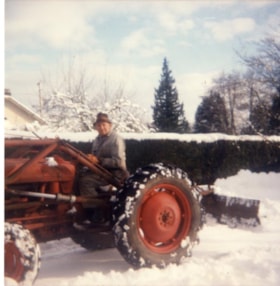
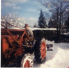
George Easthope on snow plow
https://search.heritageburnaby.ca/link/archivedescription97773
- Repository
- City of Burnaby Archives
- Date
- January 1982
- Collection/Fonds
- Burnaby Historical Society fonds
- Description Level
- Item
- Physical Description
- 1 photograph : col. ; 9 cm x 9 cm
- Scope and Content
- Photograph of George Easthope working on a snow removal machine on his property at 6671 Halifax Street.
- Repository
- City of Burnaby Archives
- Date
- January 1982
- Collection/Fonds
- Burnaby Historical Society fonds
- Subseries
- Easthope family subseries
- Physical Description
- 1 photograph : col. ; 9 cm x 9 cm
- Description Level
- Item
- Record No.
- 451-010
- Access Restriction
- No restrictions
- Reproduction Restriction
- Reproduce for fair dealing purposes only
- Accession Number
- BHS2003-06
- Scope and Content
- Photograph of George Easthope working on a snow removal machine on his property at 6671 Halifax Street.
- Names
- Easthope, George Jr.
- Media Type
- Photograph
- Notes
- Title based on contents of photograph
- Note in black pen on verso reads: "1982 January George Easthope 6671 Halifax St., Burnaby, B.C."
- Geographic Access
- Halifax Street
- Street Address
- 6671 Halifax Street
- Historic Neighbourhood
- Lochdale (Historic Neighbourhood)
- Planning Study Area
- Lochdale Area
Images
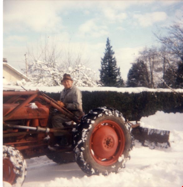
George Easthope on snow plow
https://search.heritageburnaby.ca/link/archivedescription97774
- Repository
- City of Burnaby Archives
- Date
- January 1982
- Collection/Fonds
- Burnaby Historical Society fonds
- Description Level
- Item
- Physical Description
- 1 photograph : col. ; 9 cm x 9 cm
- Scope and Content
- Photograph of George Easthope working on a snow removal machine on his property at 6671 Halifax Street.
- Repository
- City of Burnaby Archives
- Date
- January 1982
- Collection/Fonds
- Burnaby Historical Society fonds
- Subseries
- Easthope family subseries
- Physical Description
- 1 photograph : col. ; 9 cm x 9 cm
- Description Level
- Item
- Record No.
- 451-011
- Access Restriction
- No restrictions
- Reproduction Restriction
- Reproduce for fair dealing purposes only
- Accession Number
- BHS2003-06
- Scope and Content
- Photograph of George Easthope working on a snow removal machine on his property at 6671 Halifax Street.
- Names
- Easthope, George Jr.
- Media Type
- Photograph
- Notes
- Title based on contents of photograph
- Note in black pen on verso reads: "1982 January George Easthope 6671 Halifax St., Burnaby, BC"
- Geographic Access
- Halifax Street
- Street Address
- 6671 Halifax Street
- Historic Neighbourhood
- Lochdale (Historic Neighbourhood)
- Planning Study Area
- Lochdale Area
Images

Interview with Karen Morcke and Diane Hansen by Kathy Bossort October 9, 2015 - Track 1
https://search.heritageburnaby.ca/link/oralhistory563
- Repository
- City of Burnaby Archives
- Date Range
- 1965-1995
- Length
- 0:05:25
- Summary
- This portion of the interview introduces Karen Morcke and Diane Hansen. Karen Morcke talks about coming to SFU from Germany as a student in 1968 and then working as an instructor at SFU until she retired in 1995. She describes the trails on Burnaby Mountain when she first started walking them. Dian…
- Repository
- City of Burnaby Archives
- Summary
- This portion of the interview introduces Karen Morcke and Diane Hansen. Karen Morcke talks about coming to SFU from Germany as a student in 1968 and then working as an instructor at SFU until she retired in 1995. She describes the trails on Burnaby Mountain when she first started walking them. Diane Hansen describes moving to Westridge in 1971.
- Date Range
- 1965-1995
- Length
- 0:05:25
- Names
- Simon Fraser University
- Geographic Access
- Burnaby Mountain Conservation Area
- Historic Neighbourhood
- Lochdale (Historic Neighbourhood)
- Planning Study Area
- Westridge Area
- Interviewer
- Bossort, Kathy
- Interview Date
- October 9, 2015
- Scope and Content
- Recording is of an interview with Karen Morcke and Diane Hansen conducted by Kathy Bossort. Karen Morcke and Diane Hansen were two of 23 participants interviewed as part of the Community Heritage Commission’s Burnaby Mountain Oral History Project. The interview is mainly about the history and activities of the Burnaby Mountain Preservation Society of which Karen Morcke and Diane Hansen were founding members, and the environmental and recreational value of the Burnaby Mountain Conservation Area. Karen Morcke also talks about walking the trails on Burnaby Mountain from 1968 to present and her involvement in other environmental groups.
- Biographical Notes
- Diane Hansen was born in Winnipeg in 1941, trained as a nurse in Toronto, and moved with her husband Ingolf Hansen to the Westridge Area in Burnaby in 1971, where Diane lived until 2010. Diane has one daughter Kristin. Karen Morcke was born in Germany in 1940, immigrating to Canada in 1968 to attend SFU. After completing her Masters degree in 1970 Karen was hired by SFU as a language instructor from which she retired in 1995. She has one son Erik and has lived almost continuously in North Burnaby since 1968. Both Diane Hansen and Karen Morcke have been active volunteers in local environmental groups and were founding members of the Burnaby Mountain Preservation Society, which formed about 1989 to lobby for a conservation area that integrated SFU land below the campus ring road with City of Burnaby parkland on Burnaby Mountain. Diane has also been active in wild bird rescue groups. Karen walked the trails on Burnaby Mountain to and from work, and began lobbying for protection of green space on Burnaby Mountain in the 1970s.
- Total Tracks
- 6
- Total Length
- 1:10:35
- Interviewee Name
- Morcke, Karen
- Hansen, H. Diane
- Interview Location
- Karen Morcke's home in Burnaby
- Interviewer Bio
- Kathy Bossort is a retired archivist living in Ladner, BC. She worked at the Delta Museum and Archives after graduating from SLAIS (UBC) in 2001 with Masters degrees in library science and archival studies. Kathy grew up in Calgary, Alberta, and, prior to this career change, she lived in the West Kootenays, earning her living as a cook for BC tourist lodges and work camps. She continues to be interested in oral histories as a way to fill the gaps in the written record and bring richer meaning to history.
- Collection/Fonds
- Community Heritage Commission Special Projects fonds
- Media Type
- Sound Recording
Audio Tracks
Track one of interview with Karen Morcke and Diane Hansen
Track one of interview with Karen Morcke and Diane Hansen
https://search.heritageburnaby.ca/media/hpo/_Data/_Archives_Oral_Histories/_Unrestricted/MSS196-003/MSS196-003_Track_1.mp3