Narrow Results By
Subject
- Advertising Medium - Signs and Signboards 2
- Agriculture - Farms 1
- Buildings - Civic - Archives 1
- Buildings - Civic - Fire Halls 2
- Buildings - Commercial 4
- Buildings - Commercial - Offices 1
- Buildings - Commercial - Stores 4
- Buildings - Industrial - Dairies 1
- Buildings - Industrial - Factories 4
- Buildings - Residential - Condominiums 1
- Buildings - Schools 2
- Education 1

Government Road Neighbourhood
https://search.heritageburnaby.ca/link/landmark822
- Repository
- Burnaby Heritage Planning
- Associated Dates
- 1955-2008
- Heritage Value
- After the building boom of the 1950s, the Government Road Neighbourhood became characterised as a stable, single-family residential area. In addition to the residential component, the neighbourhood also has a significant industrial sector, along the north side of Burnaby Lake, and a commercial zone to the north along the Lougheed Highway.
- Historic Neighbourhood
- Lozells (Historic Neighbourhood)
- Planning Study Area
- Government Road Area
Images

Interview with Annie Boulanger by Rod Fowler April 9, 1990 - Track 6
https://search.heritageburnaby.ca/link/oralhistory488
- Repository
- City of Burnaby Archives
- Date Range
- 1925-1970
- Length
- 00:07:42
- Summary
- This portion of the interview is about Annie Boulanger’s family history, her parents’ origin, work and move to Burnaby, what the Napier Street area looked like in the 1950s and the Government Street neighbourhood in the 1960s, her education and teaching career, and her marriage. She explains why Go…
- Repository
- City of Burnaby Archives
- Summary
- This portion of the interview is about Annie Boulanger’s family history, her parents’ origin, work and move to Burnaby, what the Napier Street area looked like in the 1950s and the Government Street neighbourhood in the 1960s, her education and teaching career, and her marriage. She explains why Government Street has a jog in it at Brighton.
- Date Range
- 1925-1970
- Length
- 00:07:42
- Subjects
- Occupations - Teachers
- Historic Neighbourhood
- Vancouver Heights (Historic Neighbourhood)
- Lozells (Historic Neighbourhood)
- Planning Study Area
- Burnaby Heights Area
- Government Road Area
- Interviewer
- Fowler, Rod
- Interview Date
- April 9, 1990
- Scope and Content
- Recording is of an interview with Annie Boulanger, conducted by Rod Fowler. Annie Boulanger was one of eleven participants interviewed as part of the SFU/Burnaby Centennial Committee's oral history series titled, "Voices of Burnaby". The interview is mainly about Annie Boulanger’s volunteer community work in Burnaby, including initiating the teaching of french and gymnastics at Seaforth School where her children attended, doing historical research and oral histories for Burnaby Heritage Village and the SFU Archives, becoming a long term member of the Burnaby Writers’ Club, being a member and President of Burnaby Arts Council, and member of the Parks Board's Centre for the Performing Arts Committee (1987). The interview focuses attention on the Arts Council’s financial difficulties between 1985 and 1990, and the need for a comprehensive approach to supporting the arts through a municipal arts policy. Annie Boulanger also talks about her parents’ history, their home on Napier Street and her later home on Government Road, her education and teaching career, and her arts journalism. To view “Narrow By” terms for each track expand this description and see “Notes”.
- Biographical Notes
- Annie Urbanovits Boulanger’s parents emigrated from Hungary to Toronto, Louis in 1925 and Irene in 1930, where they married. Louis and Irene Boulanger moved to Vancouver where Louis worked in the Vancouver Shipyards during WWII and then for Nichols Chemical Company in Barnet for 15 years. While the Urbanovits family lived in Cloverdale, Louis commuted to Kask’s Camp in Barnet, until they moved to Burnaby in 1951 to an old farm purchased on Napier Street. Between 1951 and 1956 Annie completed her BA degree, majoring in chemistry and english with a minor in physical education, and obtained her teaching diploma at UBC. She taught for 4 years in various locations in BC before marrying and moving to Manitoba and Ottawa. She and her husband and five children (two more children to come later) returned to Burnaby in 1964 to a home on Government Street to be close to family. Annie Boulanger became involved in the community first through her children’s school, initiating and teaching french classes in Seaforth School in 1969, and supporting the development of gymnastics in school and as a municipal program. Her interest in Archives lead to doing oral histories for John Adams, curator of Heritage Village [Burnaby Heritage Village], and for SFU Archives. She became a long time member of the Burnaby Writers’ Club in the 1970s, taking a course in writing non-fiction from Chris Potter. In 1983 Annie Boulanger joined the Burnaby Arts Council, becoming President in 1985. She was involved in lobbying the municipality for better monetary support and facilities for the arts and for the creation of a Municipal Arts Policy. She has continued to promote the arts in Burnaby through her appointment to Burnaby’s Visual Arts Advisory Board in 1997, her arts journalism, writing regular book and theatre reviews for the local newspaper, and other activities. She was a member of the Burnaby Centennial Committee and was one of the editors of the book “Burnaby Centennial Anthology”.
- Total Tracks
- 8
- Total Length
- 0:41:53
- Interviewee Name
- Boulanger, Annie
- Interviewer Bio
- Rod Fowler returned to university as a mature student in the 1980s after working about twenty years in the field of economics and computerization in business in England, Europe and Western Canada. He graduated with a BA from SFU in both History and Sociology in 1987, his MA degree in Geography in 1989, and his PhD in Cultural Geography at SFU. He taught courses in Geography, Sociology, History and Canadian Studies at several Lower Mainland colleges, before becoming a full time member of the Geography Department at Kwantlen University College.
- Collection/Fonds
- SFU/Burnaby Centennial Committee fonds
- Transcript Available
- Transcript available
- Media Type
- Sound Recording
- Web Notes
- Interviews were digitized in 2015 allowing them to be accessible on Heritage Burnaby. The digitization project was initiated by the Community Heritage Commission with support from City of Burnaby Council.
Audio Tracks
Track six of interview with Annie Boulanger
Track six of interview with Annie Boulanger
https://search.heritageburnaby.ca/media/hpo/_Data/_Archives_Oral_Histories/_Unrestricted/MSS187-022/MSS187-022_Track_6.mp3
Interview with Robert Lowe by Eric Damer November 5, 2012 - Track 2
https://search.heritageburnaby.ca/link/oralhistory354
- Repository
- City of Burnaby Archives
- Date Range
- 1939-2012
- Length
- 0:09:13
- Summary
- This portion of the recording pertains to Robert "Bob" Lowe's memories of the development of property Burnaby. He discusses houses being built by his father, grandfather and himself; this includes the property that he and his wife bought in 1961. Bob also discusses the rise of the automobile.
- Repository
- City of Burnaby Archives
- Summary
- This portion of the recording pertains to Robert "Bob" Lowe's memories of the development of property Burnaby. He discusses houses being built by his father, grandfather and himself; this includes the property that he and his wife bought in 1961. Bob also discusses the rise of the automobile.
- Date Range
- 1939-2012
- Photo Info
- Robert "Bob" Lowe (at center) and friends riding soap box race cars, [1939]. Item no. 549-041.
- Length
- 0:09:13
- Planning Study Area
- Government Road Area
- Interviewer
- Damer, Eric
- Interview Date
- November 5, 2012
- Scope and Content
- Recording is an interview with Robert "Bob" Lowe conducted by Burnaby Village Museum employee Eric Damer, November 5, 2012. Major theme discussed: the rise of the automobile and its effect on development in Burnaby.
- Biographical Notes
- Robert "Bob" Lowe has lived his entire life in Burnaby. During his childhood, Bob’s family lived at several addresses near Royal Oak and what is now Canada Way. He attended Douglas Road Elementary and South Burnaby High Schools. After graduating, Bob worked for a few years before enrolling in Normal School for a teaching certificate. He began teaching in Vancouver, married in 1952, and started a family. The Lowes moved to Government Road in 1961 and began a hobby farm, while Bob upgraded his formal education and became an administrator in the new college system.
- Total Tracks
- 4
- Total Length
- 0:36:54
- Interviewee Name
- Lowe, Robert "Bob"
- Interview Location
- Interviewee's residence
- Interviewer Bio
- Eric Damer is a lifelong British Columbian born in Victoria, raised in Kamloops, and currently residing in Burnaby. After studying philosophy at the University of Victoria, he became interested in the educational forces that had shaped his own life. He completed master’s and doctoral degrees in educational studies at the University of British Columbia with a particular interest in the history of adult and higher education in the province. In 2012, Eric worked for the City of Burnaby as a field researcher and writer, conducting interviews for the City Archives and Museum Oral History Program.
- Collection/Fonds
- Community Heritage Commission Special Projects fonds
- Transcript Available
- None
- Media Type
- Sound Recording
Images

Audio Tracks
Track two of recording of interview with Bob Lowe
Track two of recording of interview with Bob Lowe
https://search.heritageburnaby.ca/media/hpo/_Data/_Archives_Oral_Histories/_Unrestricted/MSS171-016/MSS171-016_Track_2.mp3Interview with John Kirbyson by Kathy Bossort September 28, 2015 - Track 1
https://search.heritageburnaby.ca/link/oralhistory556
- Repository
- City of Burnaby Archives
- Date Range
- 1954-1978
- Length
- 0:09:35
- Summary
- This portion of the interview is about John Kirbyson’s early life, his family’s move to Burnaby in 1969, his connection to the outdoors, and his experience as a student at SFU earning his bachelors degree in Physical Geography. He also talks about hiking on Burnaby Mountain and working for the City…
- Repository
- City of Burnaby Archives
- Summary
- This portion of the interview is about John Kirbyson’s early life, his family’s move to Burnaby in 1969, his connection to the outdoors, and his experience as a student at SFU earning his bachelors degree in Physical Geography. He also talks about hiking on Burnaby Mountain and working for the City of Burnaby while going to school.
- Date Range
- 1954-1978
- Length
- 0:09:35
- Names
- Crampton, Colin
- Simon Fraser University
- City of Burnaby Parks, Recreation and Cultural Services
- Subjects
- Education
- Occupations
- Recreational Activities
- Geographic Access
- Burnaby Mountain Conservation Area
- Historic Neighbourhood
- Lozells (Historic Neighbourhood)
- Planning Study Area
- Government Road Area
- Interviewer
- Bossort, Kathy
- Interview Date
- September 28, 2015
- Scope and Content
- Recording is of an interview with John Kirbyson conducted by Kathy Bossort. John Kirbyson was one of 23 participants interviewed as part of the Community Heritage Commission’s Burnaby Mountain Oral History Project. The interview is mainly about John Kirbyson’s education and career as parks planner for the City of Burnaby Parks, Recreation and Cultural Services, and the development of the 1999 Burnaby Mountain Conservation Area Management Plan. The interview explores how parks management balances environmental and recreational values and safety, and the importance of good guidelines and public input in the parks planning process. John Kirbyson also talks about recreational activities and various developments on Burnaby Mountain in the 1990s, such as the Kamui Mintara sculptures.
- Biographical Notes
- John Kirbyson was born in Vancouver in 1954, to Arnold and Winnifred Kirbyson. After several years spent in Winnipeg and Calgary, the Kirbyson family moved to Hunter Street in Burnaby in 1969 where John remembers living near the City’s nursery. John earned his BSc degree at SFU in Physical Geography (1973-1978) and then worked for the City of Burnaby Parks, Recreation and Cultural Services between 1978 and 2005, where he moved from labourer to management positions. Supported by the City, he returned to SFU to earn his Masters degree in the School of Resource and Environment Management in 1991, his thesis being on restoration of Deer Lake. He was Manager of Parks Planning, Design and Development in the 1990s at the time that land on Burnaby Mountain was transferred from SFU to the City of Burnaby, and had the opportunity to direct the development of the first management plan for the Burnaby Mountain Conservation Area. From 2005 to 2010 John was Manager of the Parks, Recreation and Culture Dept. in Penticton, after which he has worked as an environmental consultant for Lees & Associates Landscape Architects and Planners. He is married to wife Linda and has three children: Linnaea, Jeremy and Colin.
- Total Tracks
- 7
- Total Length
- 1:33:43
- Interviewee Name
- Kirbyson, John W.
- Interview Location
- John Kirbyson's son's home in Langley
- Interviewer Bio
- Kathy Bossort is a retired archivist living in Ladner, BC. She worked at the Delta Museum and Archives after graduating from SLAIS (UBC) in 2001 with Masters degrees in library science and archival studies. Kathy grew up in Calgary, Alberta, and, prior to this career change, she lived in the West Kootenays, earning her living as a cook for BC tourist lodges and work camps. She continues to be interested in oral histories as a way to fill the gaps in the written record and bring richer meaning to history.
- Collection/Fonds
- Community Heritage Commission Special Projects fonds
- Media Type
- Sound Recording
Audio Tracks
Track one of interview with John Kirbyson
Track one of interview with John Kirbyson
https://search.heritageburnaby.ca/media/hpo/_Data/_Archives_Oral_Histories/_Unrestricted/MSS196-002/MSS196-002_Track_1.mp3
Foster's Kennels
https://search.heritageburnaby.ca/link/archivedescription79237
- Repository
- City of Burnaby Archives
- Date
- October, 1976
- Collection/Fonds
- Burnaby Public Library Contemporary Visual Archive Project
- Description Level
- Item
- Physical Description
- 1 photograph : b&w ; 11 x 16 cm mounted on cardboard
- Scope and Content
- Photograph shows a guard dog sign at Foster's Kennels, 7287 Lougheed Highway, Foster's Kennels specialized in training attack dogs, both German shepherds and Doberman pinschers. Shortly after the photograph was taken, the kennel relocated to Langley.
- Repository
- City of Burnaby Archives
- Date
- October, 1976
- Collection/Fonds
- Burnaby Public Library Contemporary Visual Archive Project
- Physical Description
- 1 photograph : b&w ; 11 x 16 cm mounted on cardboard
- Description Level
- Item
- Record No.
- 556-216
- Access Restriction
- No restrictions
- Reproduction Restriction
- Reproduce for fair dealing purposes only
- Accession Number
- 2013-13
- Scope and Content
- Photograph shows a guard dog sign at Foster's Kennels, 7287 Lougheed Highway, Foster's Kennels specialized in training attack dogs, both German shepherds and Doberman pinschers. Shortly after the photograph was taken, the kennel relocated to Langley.
- Names
- Foster's Kennels
- Media Type
- Photograph
- Photographer
- McCarron, John
- Notes
- Scope note taken directly from BPL photograph description.
- 1 b&w copy negative : 10 x 12.5 cm accompanying
- Geographic Access
- Lougheed Highway
- Street Address
- 7287 Lougheed Highway
- Historic Neighbourhood
- Lozells (Historic Neighbourhood)
- Planning Study Area
- Government Road Area
Images


Foster's Kennels
https://search.heritageburnaby.ca/link/archivedescription79239
- Repository
- City of Burnaby Archives
- Date
- October, 1976
- Collection/Fonds
- Burnaby Public Library Contemporary Visual Archive Project
- Description Level
- Item
- Physical Description
- 1 photograph : b&w ; 11 x 16 cm mounted on cardboard
- Scope and Content
- Photograph shows trainers with a German shepherd at Foster's Kennels on Lougheed Highway.
- Repository
- City of Burnaby Archives
- Date
- October, 1976
- Collection/Fonds
- Burnaby Public Library Contemporary Visual Archive Project
- Physical Description
- 1 photograph : b&w ; 11 x 16 cm mounted on cardboard
- Description Level
- Item
- Record No.
- 556-217
- Access Restriction
- No restrictions
- Reproduction Restriction
- Reproduce for fair dealing purposes only
- Accession Number
- 2013-13
- Scope and Content
- Photograph shows trainers with a German shepherd at Foster's Kennels on Lougheed Highway.
- Names
- Foster's Kennels
- Media Type
- Photograph
- Photographer
- McCarron, John
- Notes
- Scope note taken directly from BPL photograph description.
- 1 b&w copy negative : 10 x 12.5 cm accompanying
- Geographic Access
- Lougheed Highway
- Street Address
- 7287 Lougheed Highway
- Historic Neighbourhood
- Lozells (Historic Neighbourhood)
- Planning Study Area
- Government Road Area
Images


Dairyland Plant
https://search.heritageburnaby.ca/link/archivedescription79353
- Repository
- City of Burnaby Archives
- Date
- September 22, 1976
- Collection/Fonds
- Burnaby Public Library Contemporary Visual Archive Project
- Description Level
- Item
- Physical Description
- 1 photograph : b&w ; 11 x 16 cm mounted on cardboard
- Scope and Content
- Photograph shows a fleet of trucks outside the main Dairyland plant on Lougheed Highway near Sperling Avenue. The plant was constructed in 1964 and at the time of the photograph processed approximately 70,000 gallons of milk per day.
- Repository
- City of Burnaby Archives
- Date
- September 22, 1976
- Collection/Fonds
- Burnaby Public Library Contemporary Visual Archive Project
- Physical Description
- 1 photograph : b&w ; 11 x 16 cm mounted on cardboard
- Description Level
- Item
- Record No.
- 556-261
- Access Restriction
- No restrictions
- Reproduction Restriction
- Reproduce for fair dealing purposes only
- Accession Number
- 2013-13
- Scope and Content
- Photograph shows a fleet of trucks outside the main Dairyland plant on Lougheed Highway near Sperling Avenue. The plant was constructed in 1964 and at the time of the photograph processed approximately 70,000 gallons of milk per day.
- Subjects
- Buildings - Industrial - Dairies
- Names
- Dairyland
- Media Type
- Photograph
- Photographer
- McCarron, John
- Notes
- Scope note taken directly from BPL photograph description.
- 1 b&w copy negative : 10 x 12.5 cm accompanying
- Geographic Access
- Lougheed Highway
- Street Address
- 6800 Lougheed Highway
- Planning Study Area
- Government Road Area
Images


Target Concrete Products Ltd.
https://search.heritageburnaby.ca/link/archivedescription79397
- Repository
- City of Burnaby Archives
- Date
- October 6, 1976
- Collection/Fonds
- Burnaby Public Library Contemporary Visual Archive Project
- Description Level
- Item
- Physical Description
- 1 photograph : b&w ; 11 x 16 cm mounted on cardboard
- Scope and Content
- Photograph shows Target Concrete Products Ltd. at 7550 Conrad Street. The company, owned by B. T, Giraud dries, pre-bags, blends sand and cement and produces specialty concrete products.
- Repository
- City of Burnaby Archives
- Date
- October 6, 1976
- Collection/Fonds
- Burnaby Public Library Contemporary Visual Archive Project
- Physical Description
- 1 photograph : b&w ; 11 x 16 cm mounted on cardboard
- Description Level
- Item
- Record No.
- 556-273
- Access Restriction
- No restrictions
- Reproduction Restriction
- Reproduce for fair dealing purposes only
- Accession Number
- 2013-13
- Scope and Content
- Photograph shows Target Concrete Products Ltd. at 7550 Conrad Street. The company, owned by B. T, Giraud dries, pre-bags, blends sand and cement and produces specialty concrete products.
- Media Type
- Photograph
- Photographer
- McCarron, John
- Notes
- Scope note taken directly from BPL photograph description.
- 1 b&w copy negative : 10 x 12.5 cm accompanying
- Geographic Access
- Conrad Street
- Street Address
- 7550 Conrad Street
- Historic Neighbourhood
- Lozells (Historic Neighbourhood)
- Planning Study Area
- Government Road Area
Images


Seaforth Elementary School
https://search.heritageburnaby.ca/link/archivedescription79621
- Repository
- City of Burnaby Archives
- Date
- September 22, 1976
- Collection/Fonds
- Burnaby Public Library Contemporary Visual Archive Project
- Description Level
- Item
- Physical Description
- 1 photograph : b&w ; 11 x 16 cm mounted on cardboard
- Scope and Content
- Photograph shows bicycles parked outside Seaforth Elementary School 7881 Government Street near Piper Avenue. The older part of the school was constructed in 1922, newer portions contructed 1953-1958.
- Repository
- City of Burnaby Archives
- Date
- September 22, 1976
- Collection/Fonds
- Burnaby Public Library Contemporary Visual Archive Project
- Physical Description
- 1 photograph : b&w ; 11 x 16 cm mounted on cardboard
- Description Level
- Item
- Record No.
- 556-361
- Access Restriction
- No restrictions
- Reproduction Restriction
- Reproduce for fair dealing purposes only
- Accession Number
- 2013-13
- Scope and Content
- Photograph shows bicycles parked outside Seaforth Elementary School 7881 Government Street near Piper Avenue. The older part of the school was constructed in 1922, newer portions contructed 1953-1958.
- Names
- Seaforth School
- Media Type
- Photograph
- Photographer
- McCarron, John
- Notes
- Scope note taken directly from BPL photograph description.
- 1 b&w copy negative : 10 x 12.5 cm accompanying
- Geographic Access
- Government Road
- Street Address
- 7881 Government Road
- Historic Neighbourhood
- Lozells (Historic Neighbourhood)
- Planning Study Area
- Government Road Area
Images

Interior of Lenkurt Electric Company
https://search.heritageburnaby.ca/link/archivedescription45616
- Repository
- City of Burnaby Archives
- Date
- November 1976, published November 17, 1976
- Collection/Fonds
- Columbian Newspaper collection
- Description Level
- Item
- Physical Description
- 1 photograph : b&w ; 19.5 x 24.5 cm
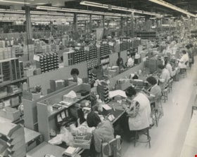
- Scope and Content
- Photograph of the interior of Lenkurt Electric's main manufacturing plant on the Lougheed Highway in Burnaby. Workers are at their desks, with their heads down, busily working. At the time of this photograph; "...1,400 employees make it one of the top secondary industries in B.C".
- Repository
- City of Burnaby Archives
- Date
- November 1976, published November 17, 1976
- Collection/Fonds
- Columbian Newspaper collection
- Physical Description
- 1 photograph : b&w ; 19.5 x 24.5 cm
- Description Level
- Item
- Record No.
- 480-510
- Access Restriction
- No restrictions
- Reproduction Restriction
- Reproduce for fair dealing purposes only
- Accession Number
- 2003-02
- Scope and Content
- Photograph of the interior of Lenkurt Electric's main manufacturing plant on the Lougheed Highway in Burnaby. Workers are at their desks, with their heads down, busily working. At the time of this photograph; "...1,400 employees make it one of the top secondary industries in B.C".
- Subjects
- Buildings - Industrial - Factories
- Names
- Lenkurt Electric Company
- Media Type
- Photograph
- Notes
- Title based on contents of photograph
- Newspaper clipping attached to verso of photograph reads: "Unit production at Lenkurt Electric's head office, research and development facility and main manufacturing plant on the Lougheed Highway in Burnaby is carried out on a semi-production basis, with a number of selected components mounted at each station. A total of 1,400 employees make it one of the top secondary industries in B.C."
- Geographic Access
- Lougheed Highway
- Street Address
- 7018 Lougheed Highway
- Historic Neighbourhood
- Lozells (Historic Neighbourhood)
- Planning Study Area
- Government Road Area
Images


Lenkurt Electric
https://search.heritageburnaby.ca/link/archivedescription93626
- Repository
- City of Burnaby Archives
- Date
- October 23, 1977
- Collection/Fonds
- Burnaby Public Library Contemporary Visual Archive Project
- Description Level
- Item
- Physical Description
- 1 photograph : b&w ; 12.5 x 17.5 cm
- Scope and Content
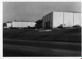
- Photograph of the exterior of Lenkurt Electric, the telecommunications equipment manufacturing plant, on Lougheed Highway at Bainbridge Avenue. The photograph is taken facing south, from across the road.
- Repository
- City of Burnaby Archives
- Date
- October 23, 1977
- Collection/Fonds
- Burnaby Public Library Contemporary Visual Archive Project
- Physical Description
- 1 photograph : b&w ; 12.5 x 17.5 cm
- Description Level
- Item
- Record No.
- 556-583
- Access Restriction
- No restrictions
- Reproduction Restriction
- Reproduce for fair dealing purposes only
- Accession Number
- 2017-57
- Scope and Content
- Photograph of the exterior of Lenkurt Electric, the telecommunications equipment manufacturing plant, on Lougheed Highway at Bainbridge Avenue. The photograph is taken facing south, from across the road.
- Media Type
- Photograph
- Photographer
- Surridge, Jack
- Notes
- Title taken from project information form
- Accompanied by a project information form and 1 photograph (b&w negative ; 9.5 x 12.5 cm)
- BPL no. 30
- Geographic Access
- Lougheed Highway
- Bainbridge Avenue
- Street Address
- 7018 Lougheed Highway
- Historic Neighbourhood
- Lozells (Historic Neighbourhood)
- Planning Study Area
- Government Road Area
Images


Warehouses - Burnaby Lake
https://search.heritageburnaby.ca/link/archivedescription93627
- Repository
- City of Burnaby Archives
- Date
- October 22, 1977
- Collection/Fonds
- Burnaby Public Library Contemporary Visual Archive Project
- Description Level
- Item
- Physical Description
- 1 photograph : b&w ; 12.5 x 17.5 cm
- Scope and Content
- Photograph of commercial and industrial buildings by Burnaby Lake on Winston Street. The photograph is taken from a high point, facing south. The photograph shows the Furniture Fair warehouse and parking lot in the foreground and the Continental Can Company plant and its water tower are in the back…
- Repository
- City of Burnaby Archives
- Date
- October 22, 1977
- Collection/Fonds
- Burnaby Public Library Contemporary Visual Archive Project
- Physical Description
- 1 photograph : b&w ; 12.5 x 17.5 cm
- Description Level
- Item
- Record No.
- 556-584
- Access Restriction
- No restrictions
- Reproduction Restriction
- Reproduce for fair dealing purposes only
- Accession Number
- 2017-57
- Scope and Content
- Photograph of commercial and industrial buildings by Burnaby Lake on Winston Street. The photograph is taken from a high point, facing south. The photograph shows the Furniture Fair warehouse and parking lot in the foreground and the Continental Can Company plant and its water tower are in the background.
- Subjects
- Buildings - Commercial - Stores
- Buildings - Industrial - Factories
- Structures - Water Tanks and Towers
- Names
- Continental Can Co.
- Media Type
- Photograph
- Photographer
- Surridge, Jack
- Notes
- Title taken from project information form
- Accompanied by a project information form and 1 photograph (b&w negative ; 9.5 x 12.5 cm)
- BPL no. 33
- Geographic Access
- Winston Street
- Burnaby Lake
- Historic Neighbourhood
- Lozells (Historic Neighbourhood)
- Planning Study Area
- Government Road Area
Images


Public Archives of Canada
https://search.heritageburnaby.ca/link/archivedescription93632
- Repository
- City of Burnaby Archives
- Date
- October 27, 1977
- Collection/Fonds
- Burnaby Public Library Contemporary Visual Archive Project
- Description Level
- Item
- Physical Description
- 1 photograph : b&w ; 12.5 x 17.5 cm
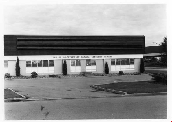
- Scope and Content
- Photograph of the exterior of the Public Archives of Canada Records Centre, located at 3127 Thunderbird Crescent. The photograph is taken from across the street, facing north.
- Repository
- City of Burnaby Archives
- Date
- October 27, 1977
- Collection/Fonds
- Burnaby Public Library Contemporary Visual Archive Project
- Physical Description
- 1 photograph : b&w ; 12.5 x 17.5 cm
- Description Level
- Item
- Record No.
- 556-589
- Access Restriction
- No restrictions
- Reproduction Restriction
- Reproduce for fair dealing purposes only
- Accession Number
- 2017-57
- Scope and Content
- Photograph of the exterior of the Public Archives of Canada Records Centre, located at 3127 Thunderbird Crescent. The photograph is taken from across the street, facing north.
- Subjects
- Buildings - Civic - Archives
- Media Type
- Photograph
- Photographer
- Surridge, Jack
- Notes
- Title taken from project information form
- Accompanied by a project information form and 1 photograph (b&w negative ; 9.5 x 12.5 cm)
- BPL no. 38
- Street Address
- 3127 Thunderbird Crescent
- Historic Neighbourhood
- Lozells (Historic Neighbourhood)
- Planning Study Area
- Government Road Area
Images

Old Seaforth School
https://search.heritageburnaby.ca/link/archivedescription93648
- Repository
- City of Burnaby Archives
- Date
- November 19, 1977
- Collection/Fonds
- Burnaby Public Library Contemporary Visual Archive Project
- Description Level
- Item
- Physical Description
- 1 photograph : b&w ; 12.5 x 17.5 cm
- Scope and Content
- Photograph of the rear exterior of two buildings of the old Seaforth School, before the original structure, built in 1922, moved to the Burnaby Village Museum in 1983. The school was located at 7881 Government Road. The photograph is taken facing northeast.
- Repository
- City of Burnaby Archives
- Date
- November 19, 1977
- Collection/Fonds
- Burnaby Public Library Contemporary Visual Archive Project
- Physical Description
- 1 photograph : b&w ; 12.5 x 17.5 cm
- Description Level
- Item
- Record No.
- 556-605
- Access Restriction
- No restrictions
- Reproduction Restriction
- Reproduce for fair dealing purposes only
- Accession Number
- 2017-57
- Scope and Content
- Photograph of the rear exterior of two buildings of the old Seaforth School, before the original structure, built in 1922, moved to the Burnaby Village Museum in 1983. The school was located at 7881 Government Road. The photograph is taken facing northeast.
- Subjects
- Buildings - Schools
- Names
- Seaforth School
- Media Type
- Photograph
- Photographer
- Surridge, Jack
- Notes
- Title taken from project information form
- Accompanied by a project information form and 1 photograph (b&w negative ; 9.5 x 12.5 cm)
- BPL no. 55
- Geographic Access
- Piper Avenue
- Government Road
- Street Address
- 7881 Government Road
- Historic Neighbourhood
- Lozells (Historic Neighbourhood)
- Planning Study Area
- Government Road Area
Images


Woodward's Furniture Fair Warehouse
https://search.heritageburnaby.ca/link/archivedescription93697
- Repository
- City of Burnaby Archives
- Date
- December, 1977
- Collection/Fonds
- Burnaby Public Library Contemporary Visual Archive Project
- Description Level
- Item
- Physical Description
- 1 photograph : b&w ; 12.5 x 17.5 cm
- Scope and Content
- Photograph of the exterior of the Furniture Fair Warehouse and Showrooms, located on Winston Street by Burnaby Lake. The photograph is taken from across the railway tracks, facing north.
- Repository
- City of Burnaby Archives
- Date
- December, 1977
- Collection/Fonds
- Burnaby Public Library Contemporary Visual Archive Project
- Physical Description
- 1 photograph : b&w ; 12.5 x 17.5 cm
- Description Level
- Item
- Record No.
- 556-654
- Access Restriction
- No restrictions
- Reproduction Restriction
- Reproduce for fair dealing purposes only
- Accession Number
- 2017-57
- Scope and Content
- Photograph of the exterior of the Furniture Fair Warehouse and Showrooms, located on Winston Street by Burnaby Lake. The photograph is taken from across the railway tracks, facing north.
- Media Type
- Photograph
- Photographer
- Surridge, Jack
- Notes
- Title taken from project information form
- Accompanied by a project information form and 1 photograph (b&w negative ; 9.5 x 12.5 cm)
- BPL no. 102
- Geographic Access
- Winston Street
- Burnaby Lake
- Historic Neighbourhood
- Lozells (Historic Neighbourhood)
- Planning Study Area
- Government Road Area
Images


#6 Firehall
https://search.heritageburnaby.ca/link/archivedescription93703
- Repository
- City of Burnaby Archives
- Date
- February 15, 1978
- Collection/Fonds
- Burnaby Public Library Contemporary Visual Archive Project
- Description Level
- Item
- Physical Description
- 1 photograph : b&w ; 12.5 x 17.5 cm
- Scope and Content
- Photograph of the front exterior of Burnaby Fire Hall No. 6, located at 3620 Brighton Avenue, at the corner of Brighton Avenue and Government Street. The photograph is taken from across Brighton Avenue, facing east. One of the fire hall's garage doors is open and a person and car are inside. The Fu…
- Repository
- City of Burnaby Archives
- Date
- February 15, 1978
- Collection/Fonds
- Burnaby Public Library Contemporary Visual Archive Project
- Physical Description
- 1 photograph : b&w ; 12.5 x 17.5 cm
- Description Level
- Item
- Record No.
- 556-660
- Access Restriction
- No restrictions
- Reproduction Restriction
- Reproduce for fair dealing purposes only
- Accession Number
- 2017-57
- Scope and Content
- Photograph of the front exterior of Burnaby Fire Hall No. 6, located at 3620 Brighton Avenue, at the corner of Brighton Avenue and Government Street. The photograph is taken from across Brighton Avenue, facing east. One of the fire hall's garage doors is open and a person and car are inside. The Furniture Fair warehouse is visible behind the fire hall.
- Names
- Burnaby Fire Department
- Media Type
- Photograph
- Photographer
- Surridge, Jack
- Notes
- Title taken from project information form
- Accompanied by a project information form and 1 photograph (b&w negative ; 9.5 x 12.5 cm)
- BPL no. 108
- Geographic Access
- Government Street
- Brighton Avenue
- Street Address
- 3620 Brighton Avenue
- Historic Neighbourhood
- Lozells (Historic Neighbourhood)
- Planning Study Area
- Government Road Area
Images

Delnor Frozen Foods
https://search.heritageburnaby.ca/link/archivedescription93704
- Repository
- City of Burnaby Archives
- Date
- February 15, 1978
- Collection/Fonds
- Burnaby Public Library Contemporary Visual Archive Project
- Description Level
- Item
- Physical Description
- 1 photograph : b&w ; 12.5 x 17.5 cm
- Scope and Content
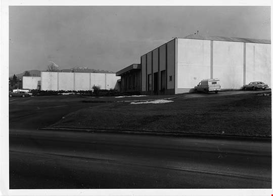
- Photograph of the exterior of Delnor Frozen Foods manufacturing facility, located at Winston Street and Bainbridge Avenue. The photograph is taken from across the road, facing north. The mountains are visible in the distance.
- Repository
- City of Burnaby Archives
- Date
- February 15, 1978
- Collection/Fonds
- Burnaby Public Library Contemporary Visual Archive Project
- Physical Description
- 1 photograph : b&w ; 12.5 x 17.5 cm
- Description Level
- Item
- Record No.
- 556-661
- Access Restriction
- No restrictions
- Reproduction Restriction
- Reproduce for fair dealing purposes only
- Accession Number
- 2017-57
- Scope and Content
- Photograph of the exterior of Delnor Frozen Foods manufacturing facility, located at Winston Street and Bainbridge Avenue. The photograph is taken from across the road, facing north. The mountains are visible in the distance.
- Subjects
- Buildings - Industrial - Factories
- Media Type
- Photograph
- Photographer
- Surridge, Jack
- Notes
- Title taken from project information form
- Accompanied by a project information form and 1 photograph (b&w negative ; 9.5 x 12.5 cm)
- BPL no. 109
- Geographic Access
- Winston Street
- Bainbridge Avenue
- Planning Study Area
- Government Road Area
Images

Restonic Mattress Warehouse
https://search.heritageburnaby.ca/link/archivedescription93705
- Repository
- City of Burnaby Archives
- Date
- February 15, 1978
- Collection/Fonds
- Burnaby Public Library Contemporary Visual Archive Project
- Description Level
- Item
- Physical Description
- 1 photograph : b&w ; 12.5 x 17.5 cm
- Scope and Content
- Photograph of the exterior of the Restonic Mattress Warehouse, located at the intersection of Winston Street and Bainbridge Avenue. The photograph is taken from opposite the intersection corner, facing northwest.
- Repository
- City of Burnaby Archives
- Date
- February 15, 1978
- Collection/Fonds
- Burnaby Public Library Contemporary Visual Archive Project
- Physical Description
- 1 photograph : b&w ; 12.5 x 17.5 cm
- Description Level
- Item
- Record No.
- 556-662
- Access Restriction
- No restrictions
- Reproduction Restriction
- Reproduce for fair dealing purposes only
- Accession Number
- 2017-57
- Scope and Content
- Photograph of the exterior of the Restonic Mattress Warehouse, located at the intersection of Winston Street and Bainbridge Avenue. The photograph is taken from opposite the intersection corner, facing northwest.
- Media Type
- Photograph
- Photographer
- Surridge, Jack
- Notes
- Title taken from project information form
- Accompanied by a project information form and 1 photograph (b&w negative ; 9.5 x 12.5 cm)
- BPL no. 110
- Geographic Access
- Winston Street
- Bainbridge Avenue
- Planning Study Area
- Government Road Area
Images


Continental Can Company
https://search.heritageburnaby.ca/link/archivedescription93708
- Repository
- City of Burnaby Archives
- Date
- February 24, 1978
- Collection/Fonds
- Burnaby Public Library Contemporary Visual Archive Project
- Description Level
- Item
- Physical Description
- 1 photograph : b&w ; 12.5 x 17.5 cm
- Scope and Content
- Photograph of the exterior of Continental Can Company factory, located on Winston Street by Burnaby Lake. The photograph is taken from across Winston Street, facing south, and the railway tracks are visible in front of the manufacturing plant. The Continental Can water tower stands in the backgroun…
- Repository
- City of Burnaby Archives
- Date
- February 24, 1978
- Collection/Fonds
- Burnaby Public Library Contemporary Visual Archive Project
- Physical Description
- 1 photograph : b&w ; 12.5 x 17.5 cm
- Description Level
- Item
- Record No.
- 556-665
- Access Restriction
- No restrictions
- Reproduction Restriction
- Reproduce for fair dealing purposes only
- Accession Number
- 2017-57
- Scope and Content
- Photograph of the exterior of Continental Can Company factory, located on Winston Street by Burnaby Lake. The photograph is taken from across Winston Street, facing south, and the railway tracks are visible in front of the manufacturing plant. The Continental Can water tower stands in the background, and there are signs on the side of the road for a "spindle sale" and Braemar Gardens.
- Names
- Continental Can Co.
- Media Type
- Photograph
- Photographer
- Surridge, Jack
- Notes
- Title taken from project information form
- Accompanied by a project information form and 1 photograph (b&w negative ; 9.5 x 12.5 cm)
- BPL no. 113
- Geographic Access
- Winston Street
- Burnaby Lake
- Historic Neighbourhood
- Lozells (Historic Neighbourhood)
- Planning Study Area
- Government Road Area
Images

![Glenrobin complex, [2000] thumbnail](/media/hpo/_Data/_Archives_Images/_Unrestricted/535/535-1688.jpg?width=280)
Glenrobin complex
https://search.heritageburnaby.ca/link/archivedescription95889
- Repository
- City of Burnaby Archives
- Date
- [2000]
- Collection/Fonds
- Burnaby NewsLeader photograph collection
- Description Level
- Item
- Physical Description
- 1 photograph (tiff) : col.
- Scope and Content
- Photograph of a woman holding a child inside the Glenrobin Place condominium complex. She is looking up from the atrium of the complex to the other floors above.
- Repository
- City of Burnaby Archives
- Date
- [2000]
- Collection/Fonds
- Burnaby NewsLeader photograph collection
- Physical Description
- 1 photograph (tiff) : col.
- Description Level
- Item
- Record No.
- 535-1688
- Access Restriction
- No restrictions
- Reproduction Restriction
- No restrictions
- Accession Number
- 2018-12
- Scope and Content
- Photograph of a woman holding a child inside the Glenrobin Place condominium complex. She is looking up from the atrium of the complex to the other floors above.
- Media Type
- Photograph
- Photographer
- Bartel, Mario
- Notes
- Title based on caption
- Collected by editorial for use in a November 2000 issue of the Burnaby NewsLeader
- Caption from metadata: "Sherri Holt, and her daughter, Trinity, in a stairwell of the Glen Robin complex, where she had lived until health problems caused by mould from leaky and rotted walls, forced her to walk away from her mortgage."
- Geographic Access
- Halston Court
- Sandlewood Crescent
- Street Address
- 9200 Sandlewood Crescent
- Planning Study Area
- Government Road Area
Images
![Glenrobin complex, [2000] thumbnail](/media/hpo/_Data/_Archives_Images/_Unrestricted/535/535-1688.jpg)