Narrow Results By
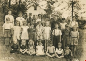
Seaforth School, Grades 1 - IV
https://search.heritageburnaby.ca/link/archivedescription37337
- Repository
- City of Burnaby Archives
- Date
- 1946
- Collection/Fonds
- Burnaby Historical Society fonds
- Description Level
- Item
- Physical Description
- 1 photograph : b&w ; 12.5 x 17.7 cm
- Scope and Content
- Photograph of twenty-four children sitting and standing in rows outside with their teacher. A label on the back of the photograph states that the students are from Seaforth School, Grades 1 - IV. The students are identified as follows: Back row (l to r), Miss MacDonald (teacher), Betty Cook, Kenny …
- Repository
- City of Burnaby Archives
- Date
- 1946
- Collection/Fonds
- Burnaby Historical Society fonds
- Subseries
- Seaforth School subseries
- Physical Description
- 1 photograph : b&w ; 12.5 x 17.7 cm
- Description Level
- Item
- Record No.
- 355-001
- Access Restriction
- No restrictions
- Reproduction Restriction
- No known restrictions
- Accession Number
- BHS1997-14
- Scope and Content
- Photograph of twenty-four children sitting and standing in rows outside with their teacher. A label on the back of the photograph states that the students are from Seaforth School, Grades 1 - IV. The students are identified as follows: Back row (l to r), Miss MacDonald (teacher), Betty Cook, Kenny Good (?), Loretta Beaton, Billy Clarke, Harvey Harding, Gordon Heather and Arthur Savage. Middle row (l to r): Albert Drappier, Clara Clarke, Betty Savage, Barbara Jean Piper, Nevella Bird, Frances Westin, Kenny Beaton, Gordon (?), and Graeme Smith. First row (l to r): Dennis Clarke, Brian Sherry, Lillian Savage, Beverly Gamble, David Werts, Charlie Sunderland, Billy Beaton.
- Subjects
- Occupations - Teachers
- Names
- Seaforth School
- MacDonald, Mary
- Cook, Betty
- Good, Kenny
- Beaton, Loretta
- Clarke, Billy
- Harding, Harvey
- Heather, Gordon
- Savage, Arthur
- Drappier, Albert
- Clarke, Clara
- Savage, Betty
- Piper, Barbara Jean
- Bird, Nevella
- Westin, Frances
- Beaton, Kenny
- Smith, Graeme
- Clarke, Dennis
- Sherry, Brian
- Savage, Lillian
- Gamble, Beverly
- Werts, David
- Sunderland, Charlie
- Beaton, Billy
- Media Type
- Photograph
- Notes
- Title based on label on verso of photograph
- Photographer identified as "Layton"
- Geographic Access
- Government Road
- Deer Lake Avenue
- Street Address
- 7881 Government Road
- 6501 Deer Lake Avenue
- Historic Neighbourhood
- Lozells (Historic Neighbourhood)
- Planning Study Area
- Government Road Area
Images

![Wedding of Gertie Sanden to Alf Boyd, [1920] (date of original) thumbnail](/media/hpo/_Data/_Archives_Images/_Unrestricted/251/312-002.jpg?width=280)
Wedding of Gertie Sanden to Alf Boyd
https://search.heritageburnaby.ca/link/archivedescription36627
- Repository
- City of Burnaby Archives
- Date
- [1920] (date of original)
- Collection/Fonds
- Burnaby Historical Society fonds
- Description Level
- Item
- Physical Description
- 1 photograph : b&w ; 8.5 x 12.5 cm print
- Scope and Content
- Photograph of the wedding of Gertie Sanden to Alf Boyd. The wedding party looks to be standing on the stairs of the Lozells Post Office at the north eastern corner of the Great Northern tracks and Piper Road. In 1908, Col. James Ward and his wife Hepezebah came to Burnaby and opened the post office…
- Repository
- City of Burnaby Archives
- Date
- [1920] (date of original)
- Collection/Fonds
- Burnaby Historical Society fonds
- Subseries
- Richard Hardy family subseries
- Physical Description
- 1 photograph : b&w ; 8.5 x 12.5 cm print
- Description Level
- Item
- Record No.
- 312-002
- Access Restriction
- No restrictions
- Reproduction Restriction
- No known restrictions
- Accession Number
- BHS1993-09
- Scope and Content
- Photograph of the wedding of Gertie Sanden to Alf Boyd. The wedding party looks to be standing on the stairs of the Lozells Post Office at the north eastern corner of the Great Northern tracks and Piper Road. In 1908, Col. James Ward and his wife Hepezebah came to Burnaby and opened the post office (naming it Lozells because when they lived in Birmingham England, Hepezebah was a parishioner in the Anglican Parish of Lozells).
- Subjects
- Ceremonies - Weddings
- Names
- Boyd, Alf
- Boyd, Gertie Sanden
- Media Type
- Photograph
- Notes
- Title based on contents of photograph
- Historic Neighbourhood
- Lozells (Historic Neighbourhood)
- Planning Study Area
- Government Road Area
Images
![Wedding of Gertie Sanden to Alf Boyd, [1920] (date of original) thumbnail](/media/hpo/_Data/_Archives_Images/_Unrestricted/251/312-002.jpg)