Narrow Results By
Subject
- Animals - Cats 1
- Animals - Dogs 1
- Animals - Poultry 1
- Buildings - Commercial 1
- Buildings - Recreational - Community Halls 1
- Buildings - Religious - Churches 2
- Buildings - Residential - Houses 2
- Ceremonies - Weddings 1
- Clothing 1
- Clothing - Military Uniforms 1
- Furniture 1
- Geographic Features - Roads 1
Person / Organization
- Bower, Janet Shankie 5
- British Columbia Telephone Company 1
- Bruce, Albert 1
- Bruce, Vera 1
- Central Park Presbyterian Church 1
- Clarke, Ellen 1
- Clarke, Joseph 1
- Ellis, Annie King 1
- Shankie, Bertha Gray, 1891-1965 1
- Shankie, Thomas Ramsay Hunter, 1920-1996 5
- Simnett, Hazel 1
- St John the Divine Anglican Church 1

Joseph Clarke House
https://search.heritageburnaby.ca/link/landmark505
- Repository
- Burnaby Heritage Planning
- Description
- The Joseph Clarke House is a two and one-half storey, wood-frame house, with shingle siding, a front-gabled roof and a full open front verandah. It is located on Jersey Avenue within the Central Park neighbourhood of Burnaby.
- Associated Dates
- 1909
- Formal Recognition
- Heritage Designation, Community Heritage Register
- Other Names
- Joseph & Ellen Clarke House, Clarke Residence
- Street View URL
- Google Maps Street View
- Repository
- Burnaby Heritage Planning
- Other Names
- Joseph & Ellen Clarke House, Clarke Residence
- Geographic Access
- Jersey Avenue
- Sandell Street
- Associated Dates
- 1909
- Formal Recognition
- Heritage Designation, Community Heritage Register
- Enactment Type
- By-law No. 11930
- Enactment Date
- 29/08/2005
- Description
- The Joseph Clarke House is a two and one-half storey, wood-frame house, with shingle siding, a front-gabled roof and a full open front verandah. It is located on Jersey Avenue within the Central Park neighbourhood of Burnaby.
- Heritage Value
- Built circa 1909 for Central Park farmer Joseph Clarke (1851-1936) and his wife, Ellen (1864-1938), this Edwardian-era farm house is valued for its vernacular design, which demonstrates the utilitarian nature of working-class housing during the boom years prior to the First World War. The Joseph Clarke House is additionally valued for its link with the development of the Central Park neighbourhood during the Edwardian era. The advent of the Central Park interurban rail line in 1892, operated by the B.C. Electric Company, connected the area to Vancouver and led to its suburban development. This is one of the oldest surviving houses in the Central Park neighbourhood. It was designated as a municipal heritage site in 2005 and rehabilitated as part of the adjacent multi-family townhouse and apartment redevelopment.
- Defining Elements
- Key elements that define the heritage character of the Joseph Clarke House include its: - location on Jersey Avenue in the Central Park neighbourhood - residential form, scale and massing as expressed by its two and one-half storey height with rectangular plan, front bay window and front-gabled roof - wood-frame construction - Edwardian era detailing such as the open front verandah, asymmetrical front entrance, glazed front door with sidelights and triangular eave brackets
- Historic Neighbourhood
- Central Park (Historic Neighbourhood)
- Planning Study Area
- Garden Village Area
- Function
- Primary Historic--Single Dwelling
- Primary Current--Single Dwelling
- Community
- Burnaby
- Cadastral Identifier
- P.I.D. 027-101-428
- Boundaries
- The Joseph Clarke House is comprised of a single residential lot located at 5575 Jersey Avenue, Burnaby.
- Area
- 2370
- Contributing Resource
- Building
- Ownership
- Private
- Documentation
- City of Burnaby Planning and Building Department, Heritage Site Files
- Names
- Clarke, Joseph
- Clarke, Ellen
- Street Address
- 5575 Jersey Avenue
- Street View URL
- Google Maps Street View
Images


St. John the Divine Anglican Church
https://search.heritageburnaby.ca/link/landmark514
- Repository
- Burnaby Heritage Planning
- Description
- St. John the Divine Anglican Church is a landmark wood-frame Gothic Revival church, with Gothic windows and spire. It is located on Kingsway, one of Burnaby’s main commercial thoroughfares, near the SkyTrain transit line and across the street from Central Park.
- Associated Dates
- 1905
- Formal Recognition
- Community Heritage Register
- Street View URL
- Google Maps Street View
- Repository
- Burnaby Heritage Planning
- Geographic Access
- Kingsway
- Associated Dates
- 1905
- Formal Recognition
- Community Heritage Register
- Enactment Type
- Council Resolution
- Enactment Date
- 09/06/2003
- Description
- St. John the Divine Anglican Church is a landmark wood-frame Gothic Revival church, with Gothic windows and spire. It is located on Kingsway, one of Burnaby’s main commercial thoroughfares, near the SkyTrain transit line and across the street from Central Park.
- Heritage Value
- St. John the Divine Anglican Church is valued as a symbol of the traditions of early Burnaby pioneers and as the oldest surviving church building in the city. Established in 1899, St. John was the first church in the community and was located at a prominent intersection of the old Vancouver-Westminster Road (now Kingsway) and the British Columbia Electric Railway’s interurban station at Central Park. This prominent intersection of the road and rail developed as the town centre of the Central Park district. The first St. John church was destroyed by fire, and was rebuilt at the same location in 1904-05. This church is additionally significant for its association with prominent local architect Joseph Henry Bowman (1864-1943) who emigrated from England in 1888. Bowman was a member of the parish, and designed both the first church and its subsequent replacement. Bowman’s prolific career embraced many stylistic changes and technological advances, and this church is a surviving example of one of his rare religious commissions. The design of the new church's nave and vestry was based on the Gothic Revival style of Christ Church Anglican in Surrey, B.C., which had been the former church of St. John’s incumbent Rev. William Bell. Evolving over time as the congregation grew, the church received a number of early additions, and in 1953 was substantially renovated and enlarged through a new design by Vancouver architect Ross Lort. The original church nave was separated from the tower and turned to allow for a large addition. The congregation relocated to a new church in 1998, and at that time removed the church's memorial windows, leaving behind a number of the original art glass windows installed in the 1920s. The church building was renovated in 2004-05, and surviving original elements were retained and restored, including of the original church tower and interior chancel ceiling. A valued feature of the building is the original cast iron church bell that remains in the tower. It was purchased by the children of the congregation in 1912, and in 1924 was rededicated on Armistice Day as a memorial to Burnaby resident Lt. James Donald McRae Reid, who died in the First World War.
- Defining Elements
- Key elements that define the heritage character of St. John the Divine Anglican Church include its: - location on the north side of Kingsway, opposite Central Park - ecclesiastical form, scale and massing as expressed by the offset tower and tall, gabled roof - tower with its original horizontal wooden drop siding, bellcast square roof with octagonal drum above and bellcast octagonal spire - cedar shingle roof cladding - metal cross at peak of spire - Gothic Revival details such as: Gothic lancet windows with leaded stained glass panels; Gothic entrance door at the base of the tower; pointed-arch louvers in the tower; and exterior gable end scissor-trusses - interior features such as wooden scissor-trusses with diagonal fir tongue and groove panelling on the ceiling above, fir tongue-and-groove panelling on the wall of the nave, and original cedar and fir pews and altar rails - cast iron bell in tower
- Historic Neighbourhood
- Central Park (Historic Neighbourhood)
- Planning Study Area
- Garden Village Area
- Architect
- Joesph Henry Bowman
- Function
- Primary Historic--Place of Worship
- Primary Current--Place of Worship
- Community
- Burnaby
- Cadastral Identifier
- 003-398-871
- Boundaries
- St. John the Divine Anglican Church is comprised of a single institutional lot located at 3891 Kingway, Burnaby.
- Area
- 3486.66
- Contributing Resource
- Building
- Ownership
- Private
- Street Address
- 3891 Kingsway
- Street View URL
- Google Maps Street View
Images


Thomas & Ellen Sanderson Residence
https://search.heritageburnaby.ca/link/landmark644
- Repository
- Burnaby Heritage Planning
- Description
- Residential building.
- Associated Dates
- 1905
- Street View URL
- Google Maps Street View
- Repository
- Burnaby Heritage Planning
- Geographic Access
- Inman Avenue
- Associated Dates
- 1905
- Description
- Residential building.
- Heritage Value
- The Sandersons were pioneer settlers in the Central Park area, arriving in Burnaby in 1904. Thomas Sanderson (1878-1936) was born in Morningside, Scotland and immigrated to British Columbia in 1899. In Vancouver in 1903, he married Ellen Jane Garvin (1883-1965), a native of Sherbrooke, Quebec. Thomas was chief of the Accounting Department at Hastings Mill, and served as Reeve of Burnaby in 1919 and 1920. One of his sons, Thomas, was a long-time teacher in Burnaby. The Sandersons’ house was built in 1905 as a small Edwardian bungalow but was extensively remodelled in the 1920s and is a fine example of the Craftsman style and today remains in good condition. Typical of the Late Craftsman style, the house has a front gabled roof, triangular eave brackets, tapered window surrounds and a mix of textural finishes, including shingles and lapped siding.
- Locality
- Central Park
- Historic Neighbourhood
- Central Park (Historic Neighbourhood)
- Planning Study Area
- Garden Village Area
- Area
- 884.53
- Contributing Resource
- Building
- Ownership
- Private
- Street Address
- 5457 Inman Avenue
- Street View URL
- Google Maps Street View
Images


![Annie King at a dance, [ca. 1938] (date of original), copied 1991 thumbnail](/media/hpo/_Data/_Archives_Images/_Unrestricted/370/370-313.jpg?width=280)
Annie King at a dance
https://search.heritageburnaby.ca/link/archivedescription37725
- Repository
- City of Burnaby Archives
- Date
- [ca. 1938] (date of original), copied 1991
- Collection/Fonds
- Burnaby Historical Society fonds
- Description Level
- Item
- Physical Description
- 1 photograph : b&w ; 3.9 x 2.6 cm print on contact sheet 20.4 x 26.5 cm
- Scope and Content
- Photograph of Annie King, seated at a table, at a social dance at St. John the Divine Anglican Church on Kingsway.
- Repository
- City of Burnaby Archives
- Date
- [ca. 1938] (date of original), copied 1991
- Collection/Fonds
- Burnaby Historical Society fonds
- Subseries
- Burnaby Image Bank subseries
- Physical Description
- 1 photograph : b&w ; 3.9 x 2.6 cm print on contact sheet 20.4 x 26.5 cm
- Description Level
- Item
- Record No.
- 370-313
- Access Restriction
- No restrictions
- Reproduction Restriction
- No restrictions
- Accession Number
- BHS1999-03
- Scope and Content
- Photograph of Annie King, seated at a table, at a social dance at St. John the Divine Anglican Church on Kingsway.
- Subjects
- Furniture
- Names
- Ellis, Annie King
- Media Type
- Photograph
- Notes
- Title based on contents of photograph
- 1 b&w copy negative accompanying
- Negative has a pink cast
- Geographic Access
- Kingsway
- Westminster Avenue
- Street Address
- 3891 Kingsway
- Historic Neighbourhood
- Central Park (Historic Neighbourhood)
- Planning Study Area
- Garden Village Area
Images
![Annie King at a dance, [ca. 1938] (date of original), copied 1991 thumbnail](/media/hpo/_Data/_Archives_Images/_Unrestricted/370/370-313.jpg)
![Bertha Shankie in garden with pets, [between 1930 and 1940] (date of original), copied [2016] thumbnail](/media/hpo/_Data/_BVM_Images/2016/201600430025_001.jpg?width=280)
Bertha Shankie in garden with pets
https://search.heritageburnaby.ca/link/museumdescription4125
- Repository
- Burnaby Village Museum
- Date
- [between 1930 and 1940] (date of original), copied [2016]
- Collection/Fonds
- Esther Love Stanley fonds
- Description Level
- Item
- Physical Description
- 1 photograph (tiff)
- Scope and Content
- Photograph of Bertha Shankie sitting on a bench in a garden. She is holding two cats and there is a dog sitting at her feet. The family's Barker Avenue home and yard is visible behind her.
- Repository
- Burnaby Village Museum
- Collection/Fonds
- Esther Love Stanley fonds
- Description Level
- Item
- Physical Description
- 1 photograph (tiff)
- Material Details
- Handwritten text in white on back of photograph reads: "Do you know Who this [?] / Looks pretty cranky".
- Scope and Content
- Photograph of Bertha Shankie sitting on a bench in a garden. She is holding two cats and there is a dog sitting at her feet. The family's Barker Avenue home and yard is visible behind her.
- Subjects
- Animals - Cats
- Animals - Dogs
- Geographic Access
- Barker Avenue
- Street Address
- 5515 Barker Avenue
- Accession Code
- BV016.43.25
- Access Restriction
- No restrictions
- Reproduction Restriction
- May be restricted by third party rights
- Date
- [between 1930 and 1940] (date of original), copied [2016]
- Media Type
- Photograph
- Historic Neighbourhood
- Central Park (Historic Neighbourhood)
- Planning Study Area
- Garden Village Area
- Notes
- Title based on contents of photograph.
- Image is from a binder of family history. Binder 1, orange cover "Old Stanley Family Photo / Old Shankie Family Photos / War Photos - Echo Photos".
- Digital image created from orginal photograph by donor
Images
![Bertha Shankie in garden with pets, [between 1930 and 1940] (date of original), copied [2016] thumbnail](/media/hpo/_Data/_BVM_Images/2016/201600430025_001.jpg)
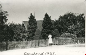
Campend
https://search.heritageburnaby.ca/link/archivedescription35144
- Repository
- City of Burnaby Archives
- Date
- 1938 (date of original), copied 1986
- Collection/Fonds
- Burnaby Historical Society fonds
- Description Level
- Item
- Physical Description
- 1 photograph : b&w ; 12.7 x 17.8 cm print
- Scope and Content
- Photograph of "Campend," the Shankie family home. Janet Shankie is standing in the gateway. The house was formerly numbered 3718 Barker Avenue and later renumbered 5155 Barker Avenue. An annotation at the bottom front of the photograph reads, "Campend 1938."
- Repository
- City of Burnaby Archives
- Date
- 1938 (date of original), copied 1986
- Collection/Fonds
- Burnaby Historical Society fonds
- Subseries
- Pioneer Tales subseries
- Physical Description
- 1 photograph : b&w ; 12.7 x 17.8 cm print
- Description Level
- Item
- Record No.
- 204-001
- Access Restriction
- No restrictions
- Reproduction Restriction
- No known restrictions
- Accession Number
- BHS1988-03
- Scope and Content
- Photograph of "Campend," the Shankie family home. Janet Shankie is standing in the gateway. The house was formerly numbered 3718 Barker Avenue and later renumbered 5155 Barker Avenue. An annotation at the bottom front of the photograph reads, "Campend 1938."
- Subjects
- Buildings - Residential - Houses
- Names
- Bower, Janet Shankie
- Media Type
- Photograph
- Notes
- Title based on caption on photograph
- Geographic Access
- Barker Avenue
- Street Address
- 5155 Barker Avenue
- Historic Neighbourhood
- Central Park (Historic Neighbourhood)
- Planning Study Area
- Garden Village Area
Images

Fire insurance plans - Greater Vancouver - Volume XVII - Municipality of Burnaby
https://search.heritageburnaby.ca/link/museumdescription17797
- Repository
- Burnaby Village Museum
- Date
- 1927-1950
- Collection/Fonds
- Burnaby Village Museum Map collection
- Description Level
- Item
- Physical Description
- 4 plans on 4 sheets : col. lithographic prints
- Scope and Content
- Item consists of fire insurance plans titled "Greater Vancouver / Volume XVII / Municipality / of Burnaby" surveyed May 1927, revised in October 1940 and September 1950. Includes a two page key plan (E and F) and two associated plans numbered 1729 and 1738 (located within District Lot 35).
- Repository
- Burnaby Village Museum
- Collection/Fonds
- Burnaby Village Museum Map collection
- Description Level
- Item
- Physical Description
- 4 plans on 4 sheets : col. lithographic prints
- Scope and Content
- Item consists of fire insurance plans titled "Greater Vancouver / Volume XVII / Municipality / of Burnaby" surveyed May 1927, revised in October 1940 and September 1950. Includes a two page key plan (E and F) and two associated plans numbered 1729 and 1738 (located within District Lot 35).
- Publisher
- Plan Department of Fire Branch of British Columbia Underwriters' Association
- Accession Code
- BV987.1.70
- Access Restriction
- No restrictions
- Reproduction Restriction
- May be restricted by third party rights
- Date
- 1927-1950
- Media Type
- Cartographic Material
- Historic Neighbourhood
- Central Park (Historic Neighbourhood)
- Planning Study Area
- Garden Village Area
- Scan Resolution
- 400
- Scan Date
- 2021-11-17
- Notes
- Title based on contents of item
- These plans were removed from a bound book with labels on cover page reading: "Plan No. 90 / THIS INSURANCE PLAN / of / Vancouver VOLUME "8" / IN THE PROPERTY OF THE / British Columbia Insurance Underwriter's Association / Vancouver B.C. / AND IS LOANED / MELVILLE F. THOMSON CO. .../ Date May 26th, 1934"; / "Plan No. 74 / THIS INSURANCE PLAN / OF / VANCOUVER VOLUME "9"" / Plan No. 11 / THIS INSURANCE PLAN / OF / BURNABY VOLUMES 15-19" / "THIS PLAN IS THE PROPERTY OF / THE / BRITISH LAW INSURANCE COMPANY / LIMITED"
- Contact Burnaby Village Museum to view associated fire insurance plans XVIII
Graduation records
https://search.heritageburnaby.ca/link/archivedescription82734
- Repository
- City of Burnaby Archives
- Date
- [1930-1941]
- Collection/Fonds
- Hazel Simnett collection
- Description Level
- File
- Physical Description
- 1 folder of textual records
- Scope and Content
- File consists of two envelopes and one dictionary. One envelope is empty and is addressed to: "To Whom it May Concern" and is from: "Hugh M. Fraser High School / 2350 Kingsway / New Westminster, BC". It most likely contained the reference letter from May 12, 1941 written by the principal of Hugh M.…
- Repository
- City of Burnaby Archives
- Date
- [1930-1941]
- Collection/Fonds
- Hazel Simnett collection
- Physical Description
- 1 folder of textual records
- Description Level
- File
- Record No.
- MSS167-013
- Accession Number
- 2013-22
- Scope and Content
- File consists of two envelopes and one dictionary. One envelope is empty and is addressed to: "To Whom it May Concern" and is from: "Hugh M. Fraser High School / 2350 Kingsway / New Westminster, BC". It most likely contained the reference letter from May 12, 1941 written by the principal of Hugh M. Fraser Senior and Junior High Schools. The second envelope is addressed to "Miss Hazel Simnett / 4019 Kingsway / New Westminster, BC" from the Department of Education in Victoria, BC. It contains the reference letter as discussed previously, a University Entrance Examination certificate, a High School Graduation certificate from Burnaby South High School, a Grade Twelve Examination Junior Matriculation certificate and a purple and gold ribbon. The dictionary is a Nelson's "Highroads" English Dictionary. Inside an inscription reads: "Hazel Simnett / 4019 Kingsway / Burnaby / BSHS / Hazel Simnett / Kingsway West School".
- Subjects
- Personal Symbols - Certificates
- Names
- Simnett, Hazel
- Media Type
- Textual Record
- Notes
- Title based on contents of file
- Simnett personal papers series
- Geographic Access
- Kingsway
- Historic Neighbourhood
- Central Park (Historic Neighbourhood)
- Planning Study Area
- Garden Village Area

Janet Shankie
https://search.heritageburnaby.ca/link/archivedescription35146
- Repository
- City of Burnaby Archives
- Date
- 1931 (date of original), copied 1986
- Collection/Fonds
- Burnaby Historical Society fonds
- Description Level
- Item
- Physical Description
- 1 photograph : b&w ; 12.7 x 17.8 cm print
- Scope and Content
- Photograph of Janet Bower (nee Shankie) in Scottish regalia. The house was formerly numbered 3718 Barker Avenue and later renumbered 5155 Barker Avenue.
- Repository
- City of Burnaby Archives
- Date
- 1931 (date of original), copied 1986
- Collection/Fonds
- Burnaby Historical Society fonds
- Subseries
- Pioneer Tales subseries
- Physical Description
- 1 photograph : b&w ; 12.7 x 17.8 cm print
- Description Level
- Item
- Record No.
- 204-003
- Access Restriction
- No restrictions
- Reproduction Restriction
- No known restrictions
- Accession Number
- BHS1988-03
- Scope and Content
- Photograph of Janet Bower (nee Shankie) in Scottish regalia. The house was formerly numbered 3718 Barker Avenue and later renumbered 5155 Barker Avenue.
- Subjects
- Clothing
- Names
- Bower, Janet Shankie
- Media Type
- Photograph
- Notes
- Title based on contents of photograph
- Geographic Access
- Barker Avenue
- Street Address
- 5155 Barker Avenue
- Historic Neighbourhood
- Central Park (Historic Neighbourhood)
- Planning Study Area
- Garden Village Area
Images


Kingsway
https://search.heritageburnaby.ca/link/archivedescription35874
- Repository
- City of Burnaby Archives
- Date
- 1900 (date of original), copied 1986
- Collection/Fonds
- Burnaby Historical Society fonds
- Description Level
- Item
- Physical Description
- 1 photograph : b&w ; 12.7 x 17.8 cm print
- Scope and Content
- Photograph of Kingsway (then Westminster Road), looking east from Boundary Road near Central Park. Included in the photograph; Central Park Presbyterian Church, Masonic Hall and Reid's Hall.
- Repository
- City of Burnaby Archives
- Date
- 1900 (date of original), copied 1986
- Collection/Fonds
- Burnaby Historical Society fonds
- Subseries
- Pioneer Tales subseries
- Physical Description
- 1 photograph : b&w ; 12.7 x 17.8 cm print
- Description Level
- Item
- Record No.
- 204-733
- Access Restriction
- No restrictions
- Reproduction Restriction
- No known restrictions
- Accession Number
- BHS1988-03
- Scope and Content
- Photograph of Kingsway (then Westminster Road), looking east from Boundary Road near Central Park. Included in the photograph; Central Park Presbyterian Church, Masonic Hall and Reid's Hall.
- Subjects
- Buildings - Recreational - Community Halls
- Buildings - Religious - Churches
- Geographic Features - Roads
- Media Type
- Photograph
- Notes
- Title based on contents of photograph
- Geographic Access
- Westminster Avenue
- Kingsway
- Street Address
- 3777 Kingsway
- Historic Neighbourhood
- Central Park (Historic Neighbourhood)
- Planning Study Area
- Garden Village Area
Images


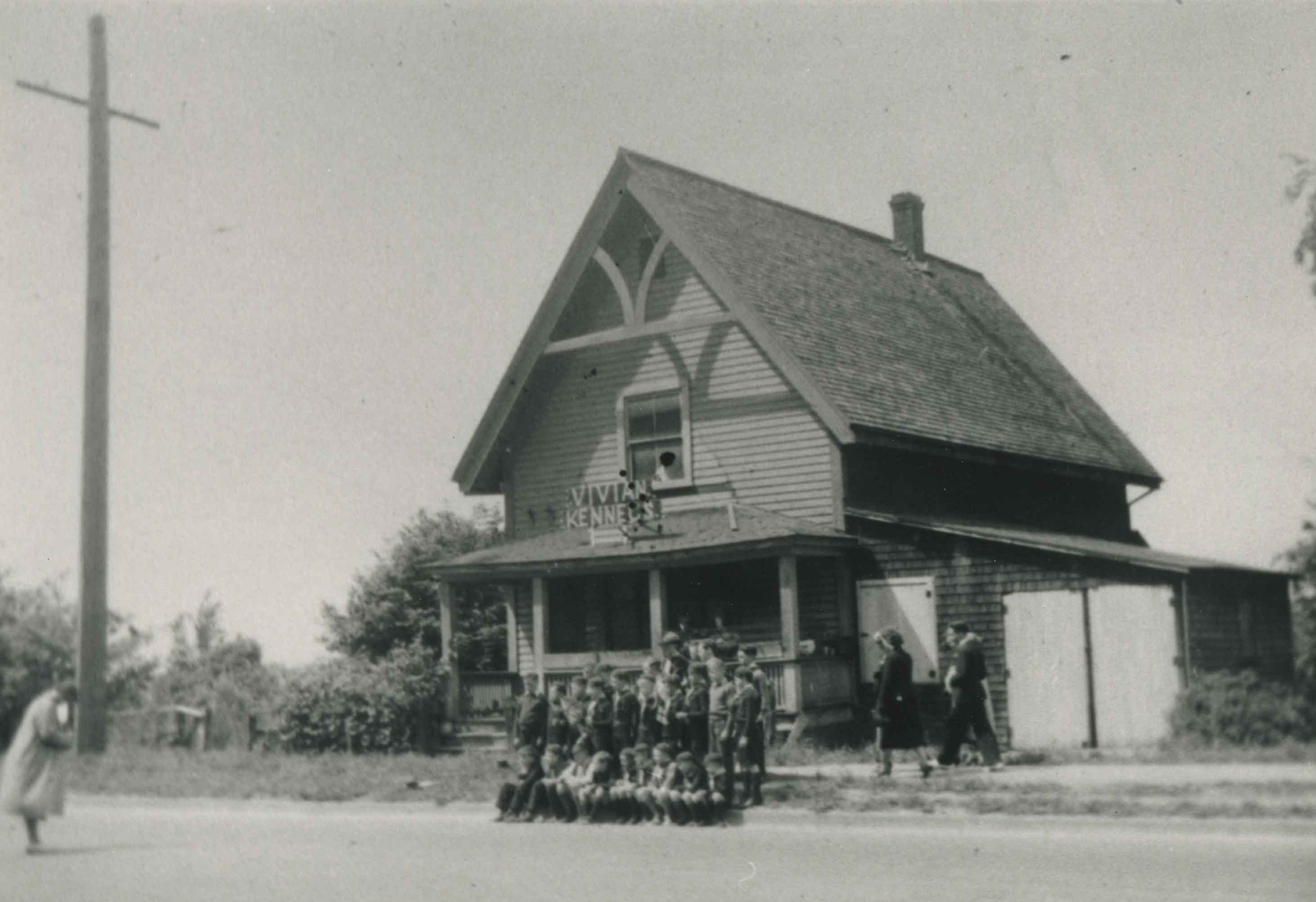
Old Presbyterian Church
https://search.heritageburnaby.ca/link/archivedescription38245
- Repository
- City of Burnaby Archives
- Date
- 1939
- Collection/Fonds
- Burnaby Historical Society fonds
- Description Level
- Item
- Physical Description
- 1 photograph : b&w ; 9 x 12.5 cm
- Scope and Content
- Photograph of approximately thirty young people posing for a picture on the sidewalk outside what has been labelled the old Presbyterian Church located at Kingsway, east of Boundary Road. A sign on the roof of the building reads "Vivian Kennels."
- Repository
- City of Burnaby Archives
- Date
- 1939
- Collection/Fonds
- Burnaby Historical Society fonds
- Subseries
- Margaret McCallum subseries
- Physical Description
- 1 photograph : b&w ; 9 x 12.5 cm
- Description Level
- Item
- Record No.
- 375-006
- Access Restriction
- No restrictions
- Reproduction Restriction
- No known restrictions
- Accession Number
- BHS1986-42
- Scope and Content
- Photograph of approximately thirty young people posing for a picture on the sidewalk outside what has been labelled the old Presbyterian Church located at Kingsway, east of Boundary Road. A sign on the roof of the building reads "Vivian Kennels."
- Subjects
- Buildings - Religious - Churches
- Media Type
- Photograph
- Notes
- Title based on contents of photograph
- Geographic Access
- Kingsway
- Historic Neighbourhood
- Central Park (Historic Neighbourhood)
- Planning Study Area
- Garden Village Area
Images
![Ramsay and Janet Shankie, [between 1926 and 1930] (date of original), copied [2016] thumbnail](/media/hpo/_Data/_BVM_Images/2015/2015_0040_0039.jpg?width=280)
Ramsay and Janet Shankie
https://search.heritageburnaby.ca/link/museumdescription5606
- Repository
- Burnaby Village Museum
- Date
- [between 1926 and 1930] (date of original), copied [2016]
- Collection/Fonds
- Esther Love Stanley fonds
- Description Level
- Item
- Physical Description
- 1 photograph (jpg)
- Scope and Content
- Photograph of young boy, Thomas Ramsay Shankie, and his sister, Janet Shankie Bower, pictured in the garden beside the family home on Barker Avenue. Ramsay is on the left and is playing the violin.
- Repository
- Burnaby Village Museum
- Collection/Fonds
- Esther Love Stanley fonds
- Description Level
- Item
- Physical Description
- 1 photograph (jpg)
- Scope and Content
- Photograph of young boy, Thomas Ramsay Shankie, and his sister, Janet Shankie Bower, pictured in the garden beside the family home on Barker Avenue. Ramsay is on the left and is playing the violin.
- Subjects
- Musical Instruments
- Geographic Access
- Barker Avenue
- Street Address
- 5515 Barker Avenue
- Accession Code
- BV015.40.39
- Access Restriction
- No restrictions
- Reproduction Restriction
- No known restrictions
- Date
- [between 1926 and 1930] (date of original), copied [2016]
- Media Type
- Photograph
- Historic Neighbourhood
- Central Park (Historic Neighbourhood)
- Planning Study Area
- Garden Village Area
- Scan Resolution
- 300
- Scan Date
- 09-Sep-18
- Notes
- Title based on annotations on digital file name
- Digital image created from orginal photograph by donor
Images
![Ramsay and Janet Shankie, [between 1926 and 1930] (date of original), copied [2016] thumbnail](/media/hpo/_Data/_BVM_Images/2015/2015_0040_0039.jpg)
![Ramsay and Janet Shankie in outdoor bathtub, 9 Aug 1931 (date of original), copied [2016] thumbnail](/media/hpo/_Data/_BVM_Images/2016/201600430035_001.jpg?width=280)
Ramsay and Janet Shankie in outdoor bathtub
https://search.heritageburnaby.ca/link/museumdescription4135
- Repository
- Burnaby Village Museum
- Date
- 9 Aug 1931 (date of original), copied [2016]
- Collection/Fonds
- Esther Love Stanley fonds
- Description Level
- Item
- Physical Description
- 1 photograph (tiff)
- Scope and Content
- Photograph of Ramsay and Janet Shankie in a garden, standing in a metal bathtub with a rooster standing next to them. The children are wearing bathing suits. A leafy tree and the Shankie family home on Barker Avenue is visible in the background.
- Repository
- Burnaby Village Museum
- Collection/Fonds
- Esther Love Stanley fonds
- Description Level
- Item
- Physical Description
- 1 photograph (tiff)
- Material Details
- Handwritten text in white on front of photograph reads: "9th Aug 1931".
- Scope and Content
- Photograph of Ramsay and Janet Shankie in a garden, standing in a metal bathtub with a rooster standing next to them. The children are wearing bathing suits. A leafy tree and the Shankie family home on Barker Avenue is visible in the background.
- Geographic Access
- Barker Avenue
- Street Address
- 5515 Barker Avenue
- Accession Code
- BV016.43.35
- Access Restriction
- No restrictions
- Reproduction Restriction
- May be restricted by third party rights
- Date
- 9 Aug 1931 (date of original), copied [2016]
- Media Type
- Photograph
- Historic Neighbourhood
- Central Park (Historic Neighbourhood)
- Planning Study Area
- Garden Village Area
- Notes
- Title based on contents of photograph.
- Image is from a binder of family history. Binder 1, orange cover "Old Stanley Family Photo / Old Shankie Family Photos / War Photos - Echo Photos".
- Digital image created from orginal photograph by donor
Images
![Ramsay and Janet Shankie in outdoor bathtub, 9 Aug 1931 (date of original), copied [2016] thumbnail](/media/hpo/_Data/_BVM_Images/2016/201600430035_001.jpg)
![Ramsay and Janet Shankie with friends, [between 1930 and 1932] (date of original), copied [2016] thumbnail](/media/hpo/_Data/_BVM_Images/2015/2015_0040_0036.jpg?width=280)
Ramsay and Janet Shankie with friends
https://search.heritageburnaby.ca/link/museumdescription5603
- Repository
- Burnaby Village Museum
- Date
- [between 1930 and 1932] (date of original), copied [2016]
- Collection/Fonds
- Esther Love Stanley fonds
- Description Level
- Item
- Physical Description
- 1 photograph (jpg)
- Scope and Content
- Group photograph of six children standing together outside the Shankie home on Barker Avenue with a blossoming tree in the background. Thomas Ramsay Shankie stands on the far left and his sister Janet Shankie stands on the far right. In between them are three smaller boys and one smaller girl.
- Repository
- Burnaby Village Museum
- Collection/Fonds
- Esther Love Stanley fonds
- Description Level
- Item
- Physical Description
- 1 photograph (jpg)
- Scope and Content
- Group photograph of six children standing together outside the Shankie home on Barker Avenue with a blossoming tree in the background. Thomas Ramsay Shankie stands on the far left and his sister Janet Shankie stands on the far right. In between them are three smaller boys and one smaller girl.
- Geographic Access
- Barker Avenue
- Street Address
- 5515 Barker Avenue
- Accession Code
- BV015.40.36
- Access Restriction
- No restrictions
- Reproduction Restriction
- No known restrictions
- Date
- [between 1930 and 1932] (date of original), copied [2016]
- Media Type
- Photograph
- Historic Neighbourhood
- Central Park (Historic Neighbourhood)
- Planning Study Area
- Garden Village Area
- Scan Resolution
- 300
- Scan Date
- 09-Sep-18
- Notes
- Title based on annotations on digital file name
- Digital image created from orginal photograph by donor
Images
![Ramsay and Janet Shankie with friends, [between 1930 and 1932] (date of original), copied [2016] thumbnail](/media/hpo/_Data/_BVM_Images/2015/2015_0040_0036.jpg)
![Ramsay Shankie and cat, 1934 (date of original), copied [2016] thumbnail](/media/hpo/_Data/_BVM_Images/2015/2015_0040_0035.jpg?width=280)
Ramsay Shankie and cat
https://search.heritageburnaby.ca/link/museumdescription5602
- Repository
- Burnaby Village Museum
- Date
- 1934 (date of original), copied [2016]
- Collection/Fonds
- Esther Love Stanley fonds
- Description Level
- Item
- Physical Description
- 1 photograph (jpg)
- Scope and Content
- Photograph of Thomas Ramsay Shankie in the garden of family home on Barker Avenue. He is seated on the edge of a washtub and holding a black cat.
- Repository
- Burnaby Village Museum
- Collection/Fonds
- Esther Love Stanley fonds
- Description Level
- Item
- Physical Description
- 1 photograph (jpg)
- Material Details
- "Ramsay / & Inky / 1934" written on front of picture in black ink.
- Scope and Content
- Photograph of Thomas Ramsay Shankie in the garden of family home on Barker Avenue. He is seated on the edge of a washtub and holding a black cat.
- Geographic Access
- Barker Avenue
- Street Address
- 5515 Barker Avenue
- Accession Code
- BV015.40.35
- Access Restriction
- No restrictions
- Reproduction Restriction
- No known restrictions
- Date
- 1934 (date of original), copied [2016]
- Media Type
- Photograph
- Historic Neighbourhood
- Central Park (Historic Neighbourhood)
- Planning Study Area
- Garden Village Area
- Scan Resolution
- 300
- Scan Date
- 09-Sep-18
- Notes
- Title based on annotations on digital file name
- Digital image created from orginal photograph by donor
Images
![Ramsay Shankie and cat, 1934 (date of original), copied [2016] thumbnail](/media/hpo/_Data/_BVM_Images/2015/2015_0040_0035.jpg)
![Ramsay Shankie with violin, Apr. 1934 (date of original), copied [2016] thumbnail](/media/hpo/_Data/_BVM_Images/2016/201600430036_001.jpg?width=280)
Ramsay Shankie with violin
https://search.heritageburnaby.ca/link/museumdescription4136
- Repository
- Burnaby Village Museum
- Date
- Apr. 1934 (date of original), copied [2016]
- Collection/Fonds
- Esther Love Stanley fonds
- Description Level
- Item
- Physical Description
- 1 photograph (tiff)
- Scope and Content
- Photograph of Ramsay Shankie holding a violin. Ramsay is wearing a light coloured shirt, a v-neck sweater and striped trousers. The Shankie family home on Barker Avenue is visible behind.
- Repository
- Burnaby Village Museum
- Collection/Fonds
- Esther Love Stanley fonds
- Description Level
- Item
- Physical Description
- 1 photograph (tiff)
- Material Details
- Handwritten text in black on front of photograph reads: "April 1934".
- Scope and Content
- Photograph of Ramsay Shankie holding a violin. Ramsay is wearing a light coloured shirt, a v-neck sweater and striped trousers. The Shankie family home on Barker Avenue is visible behind.
- Subjects
- Musical Instruments
- Geographic Access
- Barker Avenue
- Street Address
- 5515 Barker Avenue
- Accession Code
- BV016.43.36
- Access Restriction
- No restrictions
- Reproduction Restriction
- May be restricted by third party rights
- Date
- Apr. 1934 (date of original), copied [2016]
- Media Type
- Photograph
- Historic Neighbourhood
- Central Park (Historic Neighbourhood)
- Planning Study Area
- Garden Village Area
- Notes
- Title based on contents of photograph.
- Image is from a binder of family history. Binder 1, orange cover "Old Stanley Family Photo / Old Shankie Family Photos / War Photos - Echo Photos".
- Digital image created from orginal photograph by donor
Images
![Ramsay Shankie with violin, Apr. 1934 (date of original), copied [2016] thumbnail](/media/hpo/_Data/_BVM_Images/2016/201600430036_001.jpg)
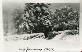
Shankie family home
https://search.heritageburnaby.ca/link/archivedescription35145
- Repository
- City of Burnaby Archives
- Date
- January 1949 (date of original), copied 1986
- Collection/Fonds
- Burnaby Historical Society fonds
- Description Level
- Item
- Physical Description
- 1 photograph : b&w ; 12.7 x 17.8 cm print
- Scope and Content
- Photograph of "Campend," the Shankie family home. This photograph was taken following winter snows. The house was formerly numbered 3718 Barker Avenue and later renumbered 5155 Barker Avenue.
- Repository
- City of Burnaby Archives
- Date
- January 1949 (date of original), copied 1986
- Collection/Fonds
- Burnaby Historical Society fonds
- Subseries
- Pioneer Tales subseries
- Physical Description
- 1 photograph : b&w ; 12.7 x 17.8 cm print
- Description Level
- Item
- Record No.
- 204-002
- Access Restriction
- No restrictions
- Reproduction Restriction
- Reproduce for fair dealing purposes only
- Accession Number
- BHS1988-03
- Scope and Content
- Photograph of "Campend," the Shankie family home. This photograph was taken following winter snows. The house was formerly numbered 3718 Barker Avenue and later renumbered 5155 Barker Avenue.
- Subjects
- Natural Phenomena - Snow
- Media Type
- Photograph
- Notes
- Title based on contents of photograph
- Geographic Access
- Barker Avenue
- Street Address
- 5155 Barker Avenue
- Historic Neighbourhood
- Central Park (Historic Neighbourhood)
- Planning Study Area
- Garden Village Area
Images

![Sondergaard family home, [193-] (date of original), copied 1992 thumbnail](/media/hpo/_Data/_Archives_Images/_Unrestricted/315/315-050.jpg?width=280)
Sondergaard family home
https://search.heritageburnaby.ca/link/archivedescription36695
- Repository
- City of Burnaby Archives
- Date
- [193-] (date of original), copied 1992
- Collection/Fonds
- Burnaby Historical Society fonds
- Description Level
- Item
- Physical Description
- 1 photograph : b&w ; 8.7 x 12.6 cm print
- Scope and Content
- Photograph of the Sondergaard family home at 4013 Inman Avenue (old street numbering) on the north side of Central Park, built by Walter Sondergaard between 1927 and 1929.
- Repository
- City of Burnaby Archives
- Date
- [193-] (date of original), copied 1992
- Collection/Fonds
- Burnaby Historical Society fonds
- Subseries
- Burnaby Centennial Anthology subseries
- Physical Description
- 1 photograph : b&w ; 8.7 x 12.6 cm print
- Description Level
- Item
- Record No.
- 315-050
- Access Restriction
- No restrictions
- Reproduction Restriction
- No known restrictions
- Accession Number
- BHS1994-04
- Scope and Content
- Photograph of the Sondergaard family home at 4013 Inman Avenue (old street numbering) on the north side of Central Park, built by Walter Sondergaard between 1927 and 1929.
- Subjects
- Buildings - Residential - Houses
- Media Type
- Photograph
- Notes
- Title based on contents of photograph
- Geographic Access
- Inman Avenue
- Street Address
- 5176 Inman Avenue
- Historic Neighbourhood
- Central Park (Historic Neighbourhood)
- Planning Study Area
- Garden Village Area
Images
![Sondergaard family home, [193-] (date of original), copied 1992 thumbnail](/media/hpo/_Data/_Archives_Images/_Unrestricted/315/315-050.jpg)

Switchboard
https://search.heritageburnaby.ca/link/archivedescription34710
- Repository
- City of Burnaby Archives
- Date
- 1943
- Collection/Fonds
- Burnaby Historical Society fonds
- Description Level
- Item
- Physical Description
- 1 photograph : b&w ; 20.0 x 25.5 cm
- Scope and Content
- Photograph of the interior of a switchboard, probably the Dexter exchange at Boundary Road and Kingsway. A typed description on the back of the photograph reads, "A Manual Switchboard, typical of about 25 years ago. / Dexter, 1943. / B.C. Telephone Company."
- Repository
- City of Burnaby Archives
- Date
- 1943
- Collection/Fonds
- Burnaby Historical Society fonds
- Subseries
- Photographs subseries
- Physical Description
- 1 photograph : b&w ; 20.0 x 25.5 cm
- Material Details
- Printed on photo paper: "selo"
- Description Level
- Item
- Record No.
- 114-001
- Access Restriction
- No restrictions
- Reproduction Restriction
- No known restrictions
- Accession Number
- BHS2007-04
- Scope and Content
- Photograph of the interior of a switchboard, probably the Dexter exchange at Boundary Road and Kingsway. A typed description on the back of the photograph reads, "A Manual Switchboard, typical of about 25 years ago. / Dexter, 1943. / B.C. Telephone Company."
- Subjects
- Telecommunication Tools and Equipment
- Buildings - Commercial
- Occupations - Telephone Operators
- Media Type
- Photograph
- Photographer
- Dominion Photo Company
- Notes
- Title based on contents of photograph
- Printed in bottom left corner of photograph, "27038 Dominion Photo Co., Vancouver B.C."
- Geographic Access
- Boundary Road
- Kingsway
- Historic Neighbourhood
- Central Park (Historic Neighbourhood)
- Planning Study Area
- Garden Village Area
Images

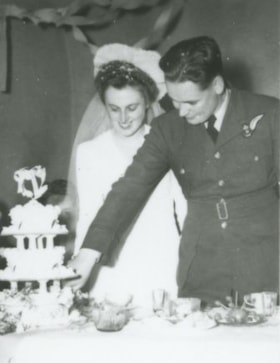
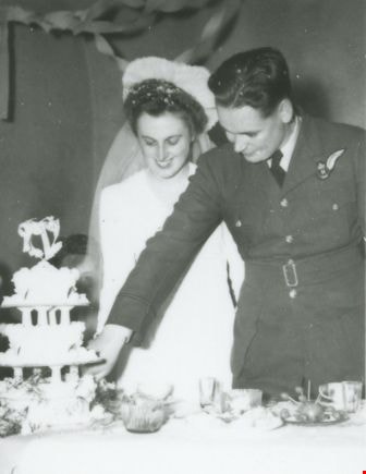
Wedding of Vera and Albert Bruce
https://search.heritageburnaby.ca/link/archivedescription37809
- Repository
- City of Burnaby Archives
- Date
- November 21, 1944 (date of original), copied 1991
- Collection/Fonds
- Burnaby Historical Society fonds
- Description Level
- Item
- Physical Description
- 1 photograph : b&w ; 4.4 x 3.1 cm print on contact sheet 20.7 x 26.7 cm
- Scope and Content
- Photograph of Vera and Albert Bruce cutting the cake at their wedding at St. John the Divine Anglican Church near Central Park. Albert is in uniform.
- Repository
- City of Burnaby Archives
- Date
- November 21, 1944 (date of original), copied 1991
- Collection/Fonds
- Burnaby Historical Society fonds
- Subseries
- Burnaby Image Bank subseries
- Physical Description
- 1 photograph : b&w ; 4.4 x 3.1 cm print on contact sheet 20.7 x 26.7 cm
- Description Level
- Item
- Record No.
- 370-397
- Access Restriction
- No restrictions
- Reproduction Restriction
- No known restrictions
- Accession Number
- BHS1999-03
- Scope and Content
- Photograph of Vera and Albert Bruce cutting the cake at their wedding at St. John the Divine Anglican Church near Central Park. Albert is in uniform.
- Media Type
- Photograph
- Notes
- Title based on contents of photograph
- 1 b&w copy negative accompanying
- Negative has a pink cast
- Geographic Access
- Kingsway
- Street Address
- 3891 Kingsway
- Historic Neighbourhood
- Central Park (Historic Neighbourhood)
- Planning Study Area
- Garden Village Area
Images