Narrow Results By
Subject
- Advertising Medium - Signs and Signboards 1
- Buildings - Civic - Hospitals 7
- Buildings - Civic - Libraries 2
- Buildings - Civic - Museums 15
- Buildings - Commercial 1
- Buildings - Commercial - Grocery Stores 1
- Buildings - Commercial - Hardware Stores 15
- Buildings - Heritage
- Buildings - Recreational - Community Halls 1
- Buildings - Recreational - Outdoor Swimming Pools 1
- Buildings - Recreational - Swimming Pools 1
- Buildings - Religious - Churches 1

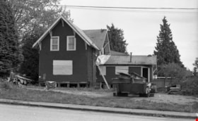
Back of Whitechurch Hardware building
https://search.heritageburnaby.ca/link/museumdescription16889
- Repository
- Burnaby Village Museum
- Date
- Aug. 1974
- Collection/Fonds
- Burnaby Village Museum fonds
- Description Level
- Item
- Physical Description
- 1 photograph : col. slide ; 35 mm
- Scope and Content
- Photograph of the back of the Whitechurch Hardware building during the preparation for the building to be moved from 7685 Sixth Street to Heritage Village (Burnaby Village Museum). The back of the building is supported with a temporary back for the move.
- Repository
- Burnaby Village Museum
- Collection/Fonds
- Burnaby Village Museum fonds
- Subseries
- Bell's building photographs subseries
- Description Level
- Item
- Physical Description
- 1 photograph : col. slide ; 35 mm
- Scope and Content
- Photograph of the back of the Whitechurch Hardware building during the preparation for the building to be moved from 7685 Sixth Street to Heritage Village (Burnaby Village Museum). The back of the building is supported with a temporary back for the move.
- Geographic Access
- 6th Street
- Street Address
- 7695 6th Street
- 7685 6th Street
- Accession Code
- BV020.5.1859
- Access Restriction
- No restrictions
- Reproduction Restriction
- No known restrictions
- Date
- Aug. 1974
- Media Type
- Photograph
- Historic Neighbourhood
- East Burnaby (Historic Neighbourhood)
- Planning Study Area
- Second Street Area
- Scan Resolution
- 2400
- Scale
- 100
- Notes
- Title based on contents of photograph
- Note in blue ink on slide frame reads: "(FRONT) / VIEW FROM THIS SIDE / WRONG SIDE / 1974 / Whitechurch Hardware / Temporary Back / Before move to HV"
- 1 col. copy print accompanying
Images


Back of Whitechurch Hardware building
https://search.heritageburnaby.ca/link/museumdescription16891
- Repository
- Burnaby Village Museum
- Date
- Aug. 1974
- Collection/Fonds
- Burnaby Village Museum fonds
- Description Level
- Item
- Physical Description
- 1 photograph : col. slide ; 35 mm
- Scope and Content
- Photograph of the back of the Whitechurch Hardware building during the preparation for the building to be moved by the Nickel Brothers house moving company from 7685 Sixth Street to Heritage Village (Burnaby Village Museum). Right section of back of the building is missing.
- Repository
- Burnaby Village Museum
- Collection/Fonds
- Burnaby Village Museum fonds
- Subseries
- Bell's building photographs subseries
- Description Level
- Item
- Physical Description
- 1 photograph : col. slide ; 35 mm
- Scope and Content
- Photograph of the back of the Whitechurch Hardware building during the preparation for the building to be moved by the Nickel Brothers house moving company from 7685 Sixth Street to Heritage Village (Burnaby Village Museum). Right section of back of the building is missing.
- Geographic Access
- 6th Street
- Street Address
- 7695 6th Street
- 7685 6th Street
- Accession Code
- BV020.5.1861
- Access Restriction
- No restrictions
- Reproduction Restriction
- No known restrictions
- Date
- Aug. 1974
- Media Type
- Photograph
- Historic Neighbourhood
- East Burnaby (Historic Neighbourhood)
- Planning Study Area
- Second Street Area
- Scan Resolution
- 2400
- Scale
- 100
- Notes
- Title based on contents of photograph
- Note in blue ink on slide frame reads: "Rear of Whitechurch / showing removed / back set on 6th St."
Images


Bricks from chimney of Whitechurch Hardware building
https://search.heritageburnaby.ca/link/museumdescription16905
- Repository
- Burnaby Village Museum
- Date
- Aug. 1974
- Collection/Fonds
- Burnaby Village Museum fonds
- Description Level
- Item
- Physical Description
- 1 photograph : col. slide ; 35 mm
- Scope and Content
- Photograph of a pile of bricks stacked on the ground next to the Whitechurch Hardware building at 7685 Sixth Street. Bricks from the chimney were removed in preparation for the building to be moved by Nickel Brothers house moving company from 7685 Sixth Street to Heritage Village (Burnaby Village M…
- Repository
- Burnaby Village Museum
- Collection/Fonds
- Burnaby Village Museum fonds
- Subseries
- Bell's building photographs subseries
- Description Level
- Item
- Physical Description
- 1 photograph : col. slide ; 35 mm
- Scope and Content
- Photograph of a pile of bricks stacked on the ground next to the Whitechurch Hardware building at 7685 Sixth Street. Bricks from the chimney were removed in preparation for the building to be moved by Nickel Brothers house moving company from 7685 Sixth Street to Heritage Village (Burnaby Village Museum).
- Geographic Access
- 6th Street
- Street Address
- 7685 6th Street
- Accession Code
- BV020.5.1875
- Access Restriction
- No restrictions
- Reproduction Restriction
- No known restrictions
- Date
- Aug. 1974
- Media Type
- Photograph
- Historic Neighbourhood
- East Burnaby (Historic Neighbourhood)
- Planning Study Area
- Second Street Area
- Scan Resolution
- 2400
- Scale
- 100
- Notes
- Title based on contents of photograph
- Note in blue ink on slide frame reads: "1974 / Whitechurch Hrdwr. / Bricks from / Chimney"
Images


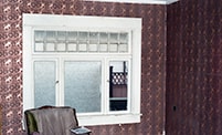
B room, northeast view and window
https://search.heritageburnaby.ca/link/museumdescription10769
- Repository
- Burnaby Village Museum
- Date
- May 12, 1988
- Collection/Fonds
- Burnaby Village Museum fonds
- Description Level
- Item
- Physical Description
- 1 photograph : b&w negative ; 35 mm
- Scope and Content
- Photograph of northeast view and window in room "B", upstairs in the Love farmhouse while it was located at 7651 Cumberland Street (the corner of 14th Avenue and Cumberland Street).
- Repository
- Burnaby Village Museum
- Collection/Fonds
- Burnaby Village Museum fonds
- Series
- Jesse Love farmhouse series
- Description Level
- Item
- Physical Description
- 1 photograph : b&w negative ; 35 mm
- Material Details
- Photograph is part of Film roll "D" - 37 b&w photographs that are a part of a collection described as BV018.41.82
- Scope and Content
- Photograph of northeast view and window in room "B", upstairs in the Love farmhouse while it was located at 7651 Cumberland Street (the corner of 14th Avenue and Cumberland Street).
- Subjects
- Buildings - Heritage
- Geographic Access
- Cumberland Street
- Street Address
- 7651 Cumberland Street
- Accession Code
- BV018.41.292
- Access Restriction
- No restrictions
- Reproduction Restriction
- No known restrictions
- Date
- May 12, 1988
- Media Type
- Photograph
- Historic Neighbourhood
- East Burnaby (Historic Neighbourhood)
- Planning Study Area
- Cariboo-Armstrong Area
- Related Material
- See BV018.41.82 for File Level Description
- Scan Resolution
- 2400
- Scan Date
- 13-May-19
- Scale
- 100
- Photographer
- Wolf, Jim
- Notes
- Title based on contents of photograph
- Photograph is a part of file level description "Photographic documentation of changes and move" BV018.41.82
Images


B room, northwest corner and bathtub
https://search.heritageburnaby.ca/link/museumdescription10770
- Repository
- Burnaby Village Museum
- Date
- May 12, 1988
- Collection/Fonds
- Burnaby Village Museum fonds
- Description Level
- Item
- Physical Description
- 1 photograph : b&w negative ; 35 mm
- Scope and Content
- Photograph of the northwest corner and bathtub in room "B", upstairs in the Love farmhouse while it was located at 7651 Cumberland Street (the corner of 14th Avenue and Cumberland Street).
- Repository
- Burnaby Village Museum
- Collection/Fonds
- Burnaby Village Museum fonds
- Series
- Jesse Love farmhouse series
- Description Level
- Item
- Physical Description
- 1 photograph : b&w negative ; 35 mm
- Material Details
- Photograph is part of Film roll "D" - 37 b&w photographs that are a part of a collection described as BV018.41.82
- Scope and Content
- Photograph of the northwest corner and bathtub in room "B", upstairs in the Love farmhouse while it was located at 7651 Cumberland Street (the corner of 14th Avenue and Cumberland Street).
- Subjects
- Buildings - Heritage
- Geographic Access
- Cumberland Street
- Street Address
- 7651 Cumberland Street
- Accession Code
- BV018.41.293
- Access Restriction
- No restrictions
- Reproduction Restriction
- No known restrictions
- Date
- May 12, 1988
- Media Type
- Photograph
- Historic Neighbourhood
- East Burnaby (Historic Neighbourhood)
- Planning Study Area
- Cariboo-Armstrong Area
- Related Material
- See BV018.41.82 for File Level Description
- Scan Resolution
- 2400
- Scan Date
- 13-May-19
- Scale
- 100
- Photographer
- Wolf, Jim
- Notes
- Title based on contents of photograph
- Photograph is a part of file level description "Photographic documentation of changes and move" BV018.41.82
Images


Ceiling in parlour
https://search.heritageburnaby.ca/link/museumdescription10812
- Repository
- Burnaby Village Museum
- Date
- April 8, 1988
- Collection/Fonds
- Burnaby Village Museum fonds
- Description Level
- Item
- Physical Description
- 1 photograph : col. negative ; 35 mm
- Scope and Content
- Photograph of the tin ceiling in the parlour inside of the Love farmhouse while it was located at 7651 Cumberland Street (the corner of 14th Avenue and Cumberland Street). The photograph was taken of the house once it was saved and acquired by the Burnaby Village Museum.
- Repository
- Burnaby Village Museum
- Collection/Fonds
- Burnaby Village Museum fonds
- Series
- Jesse Love farmhouse series
- Description Level
- Item
- Physical Description
- 1 photograph : col. negative ; 35 mm
- Material Details
- Photograph is part of Film roll "F" - 23 colour photographs that are a part of a collection described as BV018.41.82
- Scope and Content
- Photograph of the tin ceiling in the parlour inside of the Love farmhouse while it was located at 7651 Cumberland Street (the corner of 14th Avenue and Cumberland Street). The photograph was taken of the house once it was saved and acquired by the Burnaby Village Museum.
- Subjects
- Buildings - Heritage
- Geographic Access
- Cumberland Street
- Street Address
- 7651 Cumberland Street
- Accession Code
- BV018.41.334
- Access Restriction
- No restrictions
- Reproduction Restriction
- No known restrictions
- Date
- April 8, 1988
- Media Type
- Photograph
- Historic Neighbourhood
- East Burnaby (Historic Neighbourhood)
- Planning Study Area
- Cariboo-Armstrong Area
- Related Material
- See BV018.41.82 for File Level Description
- Scan Resolution
- 2400
- Scan Date
- 13-May-19
- Scale
- 100
- Photographer
- Wolf, Jim
- Notes
- Title based on contents of photograph
- Photograph is a part of file level description "Photographic documentation of changes and move" BV018.41.82
Images

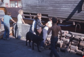
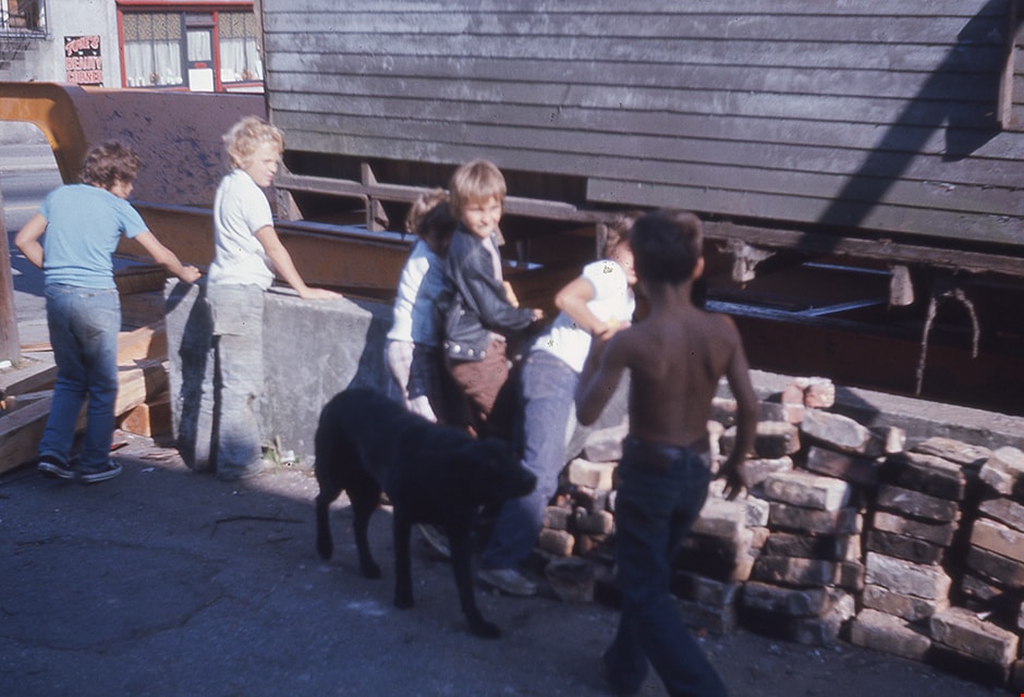
Children on site of Whitechurch Hardware
https://search.heritageburnaby.ca/link/museumdescription16894
- Repository
- Burnaby Village Museum
- Date
- Aug. 1974
- Collection/Fonds
- Burnaby Village Museum fonds
- Description Level
- Item
- Physical Description
- 1 photograph : col. slide ; 35 mm
- Scope and Content
- Photograph of a group of children and a dog gathered to watch the Whitechurch Hardware get raised up in preparation for it to be moved to Heritage Village (Burnaby Village Museum). The building is located at 7685 Sixth Street. Bricks that were removed from the building's chimney are stacked next to…
- Repository
- Burnaby Village Museum
- Collection/Fonds
- Burnaby Village Museum fonds
- Subseries
- Bell's building photographs subseries
- Description Level
- Item
- Physical Description
- 1 photograph : col. slide ; 35 mm
- Scope and Content
- Photograph of a group of children and a dog gathered to watch the Whitechurch Hardware get raised up in preparation for it to be moved to Heritage Village (Burnaby Village Museum). The building is located at 7685 Sixth Street. Bricks that were removed from the building's chimney are stacked next to the building. A building with sign "Tove's Beauty Corner" is visible across the street.
- Geographic Access
- 6th Street
- Street Address
- 7685 6th Street
- Accession Code
- BV020.5.1864
- Access Restriction
- No restrictions
- Reproduction Restriction
- No known restrictions
- Date
- Aug. 1974
- Media Type
- Photograph
- Historic Neighbourhood
- East Burnaby (Historic Neighbourhood)
- Planning Study Area
- Second Street Area
- Scan Resolution
- 2400
- Scale
- 100
- Notes
- Title based on contents of photograph
- Note in blue ink on slide frame reads: "Kids + dog + bricks / from chimney / watching jack up / Whitechurch / on 6th St. / Aug / 74"
Images

Chimney of Whitechurch Hardware
https://search.heritageburnaby.ca/link/museumdescription16897
- Repository
- Burnaby Village Museum
- Date
- Aug. 1974
- Collection/Fonds
- Burnaby Village Museum fonds
- Description Level
- Item
- Physical Description
- 1 photograph : col. slide ; 35 mm
- Scope and Content
- Photograph of the original chimney of the Whitechurch Hardware building located at 7685 Sixth Street. The building was being prepared to be moved by the Nickel Brothers house moving company to Heritage Village (Burnaby Village Museum).
- Repository
- Burnaby Village Museum
- Collection/Fonds
- Burnaby Village Museum fonds
- Subseries
- Bell's building photographs subseries
- Description Level
- Item
- Physical Description
- 1 photograph : col. slide ; 35 mm
- Scope and Content
- Photograph of the original chimney of the Whitechurch Hardware building located at 7685 Sixth Street. The building was being prepared to be moved by the Nickel Brothers house moving company to Heritage Village (Burnaby Village Museum).
- Geographic Access
- 6th Street
- Street Address
- 7685 6th Street
- Accession Code
- BV020.5.1867
- Access Restriction
- No restrictions
- Reproduction Restriction
- No known restrictions
- Date
- Aug. 1974
- Media Type
- Photograph
- Historic Neighbourhood
- East Burnaby (Historic Neighbourhood)
- Planning Study Area
- Second Street Area
- Scan Resolution
- 2400
- Scale
- 100
- Notes
- Title based on contents of photograph
- Note in blue ink on slide frame reads: "Chimney of / Whitechurch (original)"
Images


Cooling cupboard in basement
https://search.heritageburnaby.ca/link/museumdescription10867
- Repository
- Burnaby Village Museum
- Date
- April 11, 1988
- Collection/Fonds
- Burnaby Village Museum fonds
- Description Level
- Item
- Physical Description
- 1 photograph : b&w negative ; 35 mm
- Scope and Content
- Photograph of cooling cupboard in along the wast wall in the basement of the Love farmhouse located at 7651 Cumberland Street (the corner of 14th Avenue and Cumberland Street). The photograph was taken of the house once it was saved and acquired by the Burnaby Village Museum.
- Repository
- Burnaby Village Museum
- Collection/Fonds
- Burnaby Village Museum fonds
- Series
- Jesse Love farmhouse series
- Description Level
- Item
- Physical Description
- 1 photograph : b&w negative ; 35 mm
- Material Details
- Photograph is part of Film roll "H" - 36 b&w photographs that are a part of a collection described as BV018.41.82
- Scope and Content
- Photograph of cooling cupboard in along the wast wall in the basement of the Love farmhouse located at 7651 Cumberland Street (the corner of 14th Avenue and Cumberland Street). The photograph was taken of the house once it was saved and acquired by the Burnaby Village Museum.
- Subjects
- Buildings - Heritage
- Geographic Access
- Cumberland Street
- Street Address
- 7651 Cumberland Street
- Accession Code
- BV018.41.389
- Access Restriction
- No restrictions
- Reproduction Restriction
- No known restrictions
- Date
- April 11, 1988
- Media Type
- Photograph
- Historic Neighbourhood
- East Burnaby (Historic Neighbourhood)
- Planning Study Area
- Cariboo-Armstrong Area
- Related Material
- See BV018.41.82 for File Level Description
- Scan Resolution
- 2400
- Scan Date
- 6/3/2019
- Scale
- 100
- Photographer
- Wolf, Jim
- Notes
- Title based on contents of photograph
- Photograph is a part of file level description "Photographic documentation of changes and move" BV018.41.82
Images

![Corner view of Love farmhouse, [between 1966 and 1970] thumbnail](/media/hpo/_Data/_BVM_Images/2019/2019_0003_0005_001.jpg?width=280)
Corner view of Love farmhouse
https://search.heritageburnaby.ca/link/museumdescription9919
- Repository
- Burnaby Village Museum
- Date
- [between 1966 and 1970]
- Collection/Fonds
- Love family fonds
- Description Level
- Item
- Physical Description
- 1 photograph : col. ; 10 x 15 cm print
- Scope and Content
- Photograph of the exterior of the Love farmhouse taken at the corner of Fourteenth Avenue and Cumberland Street. The house is hidden behind large trees at it's orignal address of 7651 Cumberland Street (Address pre 1960: 1390 Cumberland Road). This photograph was taken while Elsie Hughes (nee Love)…
- Repository
- Burnaby Village Museum
- Collection/Fonds
- Love family fonds
- Description Level
- Item
- Physical Description
- 1 photograph : col. ; 10 x 15 cm print
- Material Details
- Copy print was made from re-photographing an original colour slide
- Scope and Content
- Photograph of the exterior of the Love farmhouse taken at the corner of Fourteenth Avenue and Cumberland Street. The house is hidden behind large trees at it's orignal address of 7651 Cumberland Street (Address pre 1960: 1390 Cumberland Road). This photograph was taken while Elsie Hughes (nee Love), her husband John Hughes and son Brent Hughes lived in the house. Elsie is the daughter of Sarah (nee Love) and William Parker. Sarah and William purchased the house in 1928, shortly after the death of Sarah's father, Jesse Love. Sarah and William Parker lived in the house with their three children, Albert, Bill and Elsie. William Parker died in 1961 and Sarah continued to live in the house until 1966 before selling it to her daughter Elsie and son in law John Hughes. Elsie and John lived in the house with their son Brent until 1971.
- Subjects
- Buildings - Heritage
- Geographic Access
- 14th Avenue
- Cumberland Street
- Street Address
- 7651 Cumberland Street
- Accession Code
- BV019.3.5
- Access Restriction
- No restrictions
- Reproduction Restriction
- No known restrictions
- Date
- [between 1966 and 1970]
- Media Type
- Photograph
- Historic Neighbourhood
- East Burnaby (Historic Neighbourhood)
- Planning Study Area
- Cariboo-Armstrong Area
- Scan Resolution
- 600
- Scan Date
- 31-Jan-2019
- Scale
- 96
- Photographer
- Parker, Albert "Bert"
- Notes
- Title based on contents of photograph
- See also BV992.15.12
Images
![Corner view of Love farmhouse, [between 1966 and 1970] thumbnail](/media/hpo/_Data/_BVM_Images/2019/2019_0003_0005_001.jpg)
![Corner view of Love farmhouse, [between 1966 and 1970] thumbnail](/media/hpo/_Data/_BVM_Images/2019/2019_0003_0006_001.jpg?width=280)
Corner view of Love farmhouse
https://search.heritageburnaby.ca/link/museumdescription9920
- Repository
- Burnaby Village Museum
- Date
- [between 1966 and 1970]
- Collection/Fonds
- Love family fonds
- Description Level
- Item
- Physical Description
- 1 photograph : col. ; 10 x 15 cm print
- Scope and Content
- Photograph of the exterior of the Love farmhouse taken at the corner of Fourteenth Avenue and Cumberland Street. The north side of the house and kitchen are in view with large trees covering the front of the house at it's orignal address of 7651 Cumberland Street (Address pre 1960: 1390 Cumberland …
- Repository
- Burnaby Village Museum
- Collection/Fonds
- Love family fonds
- Description Level
- Item
- Physical Description
- 1 photograph : col. ; 10 x 15 cm print
- Material Details
- Copy print was made from re-photographing an original colour slide
- Scope and Content
- Photograph of the exterior of the Love farmhouse taken at the corner of Fourteenth Avenue and Cumberland Street. The north side of the house and kitchen are in view with large trees covering the front of the house at it's orignal address of 7651 Cumberland Street (Address pre 1960: 1390 Cumberland Road). This photograph was taken while Elsie Hughes (nee Love), her husband John Hughes and son Brent Hughes lived in the house. Elsie is the daughter of Sarah (nee Love) and William Parker. Sarah and William purchased the house in 1928, shortly after the death of Sarah's father, Jesse Love. Sarah and William Parker lived in the house with their three children, Albert, Bill and Elsie. William Parker died in 1961 and Sarah continued to live in the house until 1966 before selling it to her daughter Elsie and son in law John Hughes. Elsie and John lived in the house with their son Brent until 1971.
- Subjects
- Buildings - Heritage
- Geographic Access
- 14th Avenue
- Cumberland Street
- Street Address
- 7651 Cumberland Street
- Accession Code
- BV019.3.6
- Access Restriction
- No restrictions
- Reproduction Restriction
- No known restrictions
- Date
- [between 1966 and 1970]
- Media Type
- Photograph
- Historic Neighbourhood
- East Burnaby (Historic Neighbourhood)
- Planning Study Area
- Cariboo-Armstrong Area
- Scan Resolution
- 600
- Scan Date
- 31-Jan-2019
- Scale
- 96
- Photographer
- Parker, Albert "Bert"
- Notes
- Title based on contents of photograph
- See also BV992.15.12
Images
![Corner view of Love farmhouse, [between 1966 and 1970] thumbnail](/media/hpo/_Data/_BVM_Images/2019/2019_0003_0006_001.jpg)

C room north wall and window
https://search.heritageburnaby.ca/link/museumdescription10767
- Repository
- Burnaby Village Museum
- Date
- May 12, 1988
- Collection/Fonds
- Burnaby Village Museum fonds
- Description Level
- Item
- Physical Description
- 1 photograph : b&w negative ; 35 mm
- Scope and Content
- Photograph of the north wall and window in room "C", upstairs in the Love farmhouse while it was located at 7651 Cumberland Street (the corner of 14th Avenue and Cumberland Street).
- Repository
- Burnaby Village Museum
- Collection/Fonds
- Burnaby Village Museum fonds
- Series
- Jesse Love farmhouse series
- Description Level
- Item
- Physical Description
- 1 photograph : b&w negative ; 35 mm
- Material Details
- Photograph is part of Film roll "D" - 37 b&w photographs that are a part of a collection described as BV018.41.82
- Scope and Content
- Photograph of the north wall and window in room "C", upstairs in the Love farmhouse while it was located at 7651 Cumberland Street (the corner of 14th Avenue and Cumberland Street).
- Subjects
- Buildings - Heritage
- Geographic Access
- Cumberland Street
- Street Address
- 7651 Cumberland Street
- Accession Code
- BV018.41.290
- Access Restriction
- No restrictions
- Reproduction Restriction
- No known restrictions
- Date
- May 12, 1988
- Media Type
- Photograph
- Historic Neighbourhood
- East Burnaby (Historic Neighbourhood)
- Planning Study Area
- Cariboo-Armstrong Area
- Related Material
- See BV018.41.82 for File Level Description
- Scan Resolution
- 2400
- Scan Date
- 13-May-19
- Scale
- 100
- Photographer
- Wolf, Jim
- Notes
- Title based on contents of photograph
- Photograph is a part of file level description "Photographic documentation of changes and move" BV018.41.82
Images


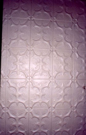
Detail of tin ceiling in entrance hallway
https://search.heritageburnaby.ca/link/museumdescription9978
- Repository
- Burnaby Village Museum
- Date
- 1988
- Collection/Fonds
- Burnaby Village Museum fonds
- Description Level
- Item
- Physical Description
- 1 photograph : b&w negative ; 35 mm
- Scope and Content
- Photograph detail of the painted tin ceiling in the entrance hallway of the Love farmhouse. The photograph was taken while the house was still located at 7651 Cumberland Street before being moved to the Burnaby Village Museum in May 1988. The original tin ceiling was restored and painted on the sit…
- Repository
- Burnaby Village Museum
- Collection/Fonds
- Burnaby Village Museum fonds
- Series
- Jesse Love farmhouse series
- Description Level
- Item
- Physical Description
- 1 photograph : b&w negative ; 35 mm
- Scope and Content
- Photograph detail of the painted tin ceiling in the entrance hallway of the Love farmhouse. The photograph was taken while the house was still located at 7651 Cumberland Street before being moved to the Burnaby Village Museum in May 1988. The original tin ceiling was restored and painted on the site of the Burnaby Village Museum.
- Subjects
- Buildings - Heritage
- Geographic Access
- Cumberland Street
- Street Address
- 7651 Cumberland Street
- Accession Code
- BV018.41.165
- Access Restriction
- No restrictions
- Reproduction Restriction
- May be restricted by third party rights
- Date
- 1988
- Media Type
- Photograph
- Historic Neighbourhood
- East Burnaby (Historic Neighbourhood)
- Planning Study Area
- Cariboo-Armstrong Area
- Scan Resolution
- 1000
- Scan Date
- 31-Jan-2019
- Scale
- 100
- Notes
- Title based on contents of photograph
- Photograph is one of a group of 25 photographs that were taken by Jim Wolf (not all photographs were described)
- See BV988.33.34 for description of artifact
Images

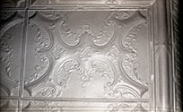
Detail of tin ceiling in music room
https://search.heritageburnaby.ca/link/museumdescription10257
- Repository
- Burnaby Village Museum
- Date
- Aug. 28, 1988
- Collection/Fonds
- Burnaby Village Museum fonds
- Description Level
- Item
- Physical Description
- 1 photograph : col. slide ; 35 mm
- Scope and Content
- Photograph detail of the tin ceiling in the Love farmhouse music room (parlour). Photograph was taken prior to the ceiling being restored.
- Repository
- Burnaby Village Museum
- Collection/Fonds
- Burnaby Village Museum fonds
- Series
- Jesse Love farmhouse series
- Description Level
- Item
- Physical Description
- 1 photograph : col. slide ; 35 mm
- Scope and Content
- Photograph detail of the tin ceiling in the Love farmhouse music room (parlour). Photograph was taken prior to the ceiling being restored.
- Subjects
- Buildings - Heritage
- Geographic Access
- Cumberland Street
- Street Address
- 7651 Cumberland Street
- Accession Code
- BV018.41.145
- Access Restriction
- No restrictions
- Reproduction Restriction
- No known restrictions
- Date
- Aug. 28, 1988
- Media Type
- Photograph
- Historic Neighbourhood
- East Burnaby (Historic Neighbourhood)
- Planning Study Area
- Cariboo-Armstrong Area
- Scan Resolution
- 600
- Scan Date
- 24-Feb-19
- Scale
- 96
- Photographer
- Wolf, Jim
- Notes
- Title based on contents of photograph
Images

Detail of tin ceiling tile
https://search.heritageburnaby.ca/link/museumdescription9976
- Repository
- Burnaby Village Museum
- Date
- 1988
- Collection/Fonds
- Burnaby Village Museum fonds
- Description Level
- Item
- Physical Description
- 1 photograph : b&w negative ; 35 mm
- Scope and Content
- Photograph detail of the tin ceiling that was in the parlour of the Love farmhouse. The photograph was taken while the house was still located at 7651 Cumberland Street before being moved to the Burnaby Village Museum in May 1988. The original tin ceiling was restored and painted on the site of th…
- Repository
- Burnaby Village Museum
- Collection/Fonds
- Burnaby Village Museum fonds
- Series
- Jesse Love farmhouse series
- Description Level
- Item
- Physical Description
- 1 photograph : b&w negative ; 35 mm
- Scope and Content
- Photograph detail of the tin ceiling that was in the parlour of the Love farmhouse. The photograph was taken while the house was still located at 7651 Cumberland Street before being moved to the Burnaby Village Museum in May 1988. The original tin ceiling was restored and painted on the site of the Burnaby Village Museum.
- Subjects
- Buildings - Heritage
- Geographic Access
- Cumberland Street
- Street Address
- 7651 Cumberland Street
- Accession Code
- BV018.41.163
- Access Restriction
- No restrictions
- Reproduction Restriction
- May be restricted by third party rights
- Date
- 1988
- Media Type
- Photograph
- Historic Neighbourhood
- East Burnaby (Historic Neighbourhood)
- Planning Study Area
- Cariboo-Armstrong Area
- Scan Resolution
- 1000
- Scan Date
- 31-Jan-2019
- Scale
- 100
- Notes
- Title based on contents of photograph
- Photograph is one of a group of 25 photographs that were taken by Jim Wolf (not all photographs were described)
- See BV988.33.34 for description of artifact
Images
Dining room, south view
https://search.heritageburnaby.ca/link/museumdescription10825
- Repository
- Burnaby Village Museum
- Date
- April 11, 1988
- Collection/Fonds
- Burnaby Village Museum fonds
- Description Level
- Item
- Physical Description
- 1 photograph : col. negative ; 35 mm
- Scope and Content
- South view of the dining room inside of the Love farmhouse while it was located at 7651 Cumberland Street (the corner of 14th Avenue and Cumberland Street). The photograph was taken of the house once it was saved and acquired by the Burnaby Village Museum.
- Repository
- Burnaby Village Museum
- Collection/Fonds
- Burnaby Village Museum fonds
- Series
- Jesse Love farmhouse series
- Description Level
- Item
- Physical Description
- 1 photograph : col. negative ; 35 mm
- Material Details
- Photograph is part of Film roll "G" - 36 colour photographs that are a part of a collection described as BV018.41.82
- Scope and Content
- South view of the dining room inside of the Love farmhouse while it was located at 7651 Cumberland Street (the corner of 14th Avenue and Cumberland Street). The photograph was taken of the house once it was saved and acquired by the Burnaby Village Museum.
- Subjects
- Buildings - Heritage
- Geographic Access
- Cumberland Street
- Street Address
- 7651 Cumberland Street
- Accession Code
- BV018.41.347
- Access Restriction
- No restrictions
- Reproduction Restriction
- No known restrictions
- Date
- April 11, 1988
- Media Type
- Photograph
- Historic Neighbourhood
- East Burnaby (Historic Neighbourhood)
- Planning Study Area
- Cariboo-Armstrong Area
- Related Material
- See BV018.41.82 for File Level Description
- Scan Resolution
- 2400
- Scan Date
- 27-May-19
- Scale
- 100
- Photographer
- Wolf, Jim
- Notes
- Title based on contents of photograph
- Photograph is a part of file level description "Photographic documentation of changes and move" BV018.41.82
Images
East elevation
https://search.heritageburnaby.ca/link/museumdescription10808
- Repository
- Burnaby Village Museum
- Date
- April 8, 1988
- Collection/Fonds
- Burnaby Village Museum fonds
- Description Level
- Item
- Physical Description
- 1 photograph : col. negative ; 35 mm
- Scope and Content
- Photograph of the eastern elevation of the Love farmhouse while it was located at 7651 Cumberland Street (the corner of 14th Avenue and Cumberland Street). The photograph was taken of the house once it was saved and acquired by the Burnaby Village Museum.
- Repository
- Burnaby Village Museum
- Collection/Fonds
- Burnaby Village Museum fonds
- Series
- Jesse Love farmhouse series
- Description Level
- Item
- Physical Description
- 1 photograph : col. negative ; 35 mm
- Material Details
- Photograph is part of Film roll "F" - 23 colour photographs that are a part of a collection described as BV018.41.82
- Scope and Content
- Photograph of the eastern elevation of the Love farmhouse while it was located at 7651 Cumberland Street (the corner of 14th Avenue and Cumberland Street). The photograph was taken of the house once it was saved and acquired by the Burnaby Village Museum.
- Subjects
- Buildings - Heritage
- Geographic Access
- Cumberland Street
- Street Address
- 7651 Cumberland Street
- Accession Code
- BV018.41.330
- Access Restriction
- No restrictions
- Reproduction Restriction
- No known restrictions
- Date
- April 8, 1988
- Media Type
- Photograph
- Historic Neighbourhood
- East Burnaby (Historic Neighbourhood)
- Planning Study Area
- Cariboo-Armstrong Area
- Related Material
- See BV018.41.82 for File Level Description
- Scan Resolution
- 2400
- Scan Date
- 13-May-19
- Scale
- 100
- Photographer
- Wolf, Jim
- Notes
- Title based on contents of photograph
- Photograph is a part of file level description "Photographic documentation of changes and move" BV018.41.82
Images

Exterior demolition, north facade
https://search.heritageburnaby.ca/link/museumdescription10883
- Repository
- Burnaby Village Museum
- Date
- April 11, 1988
- Collection/Fonds
- Burnaby Village Museum fonds
- Description Level
- Item
- Physical Description
- 1 photograph : b&w negative ; 35 mm
- Scope and Content
- Photograph of exterior demolition of north facade inside of the Love farmhouse while it was located at 7651 Cumberland Street (the corner of 14th Avenue and Cumberland Street). The photograph was taken of the house once it was saved and acquired by the Burnaby Village Museum.
- Repository
- Burnaby Village Museum
- Collection/Fonds
- Burnaby Village Museum fonds
- Series
- Jesse Love farmhouse series
- Description Level
- Item
- Physical Description
- 1 photograph : b&w negative ; 35 mm
- Material Details
- Photograph is part of Film roll "H" - 36 b&w photographs that are a part of a collection described as BV018.41.82
- Scope and Content
- Photograph of exterior demolition of north facade inside of the Love farmhouse while it was located at 7651 Cumberland Street (the corner of 14th Avenue and Cumberland Street). The photograph was taken of the house once it was saved and acquired by the Burnaby Village Museum.
- Subjects
- Buildings - Heritage
- Geographic Access
- Cumberland Street
- Street Address
- 7651 Cumberland Street
- Accession Code
- BV018.41.405
- Access Restriction
- No restrictions
- Reproduction Restriction
- No known restrictions
- Date
- April 11, 1988
- Media Type
- Photograph
- Historic Neighbourhood
- East Burnaby (Historic Neighbourhood)
- Planning Study Area
- Cariboo-Armstrong Area
- Related Material
- See BV018.41.82 for File Level Description
- Scan Resolution
- 2400
- Scan Date
- 6/3/2019
- Scale
- 100
- Photographer
- Wolf, Jim
- Notes
- Title based on contents of photograph
- Photograph is a part of file level description "Photographic documentation of changes and move" BV018.41.82
Images


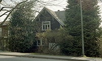
Exterior of Love farmhouse
https://search.heritageburnaby.ca/link/museumdescription1129
- Repository
- Burnaby Village Museum
- Date
- 1971 (date of original), copied 1990
- Collection/Fonds
- Love family fonds
- Description Level
- Item
- Physical Description
- 1 photograph : col. ; 10 x 15 cm print
- Scope and Content
- Photograph of the northern exterior of the Love farmhouse while Elsie (nee Love) Hughes, her husband John and son Brent lived in the house. The one storey section housed the kitchen which was added in 1903 to the original house which was built in 1893. The house is located at 7651 Cumberland Stree…
- Repository
- Burnaby Village Museum
- Collection/Fonds
- Love family fonds
- Description Level
- Item
- Physical Description
- 1 photograph : col. ; 10 x 15 cm print
- Material Details
- Copy print was made from re-photographing an original colour slide
- Scope and Content
- Photograph of the northern exterior of the Love farmhouse while Elsie (nee Love) Hughes, her husband John and son Brent lived in the house. The one storey section housed the kitchen which was added in 1903 to the original house which was built in 1893. The house is located at 7651 Cumberland Street (Address pre 1960: 1390 Cumberland Road) and was moved from its original site to the Burnaby Village Museum in 1988 and designated a Municipal Heritage Landmark in 1992.
- Geographic Access
- Cumberland Street
- Street Address
- 7651 Cumberland Street
- Accession Code
- BV992.15.10
- Access Restriction
- Restricted access
- Reproduction Restriction
- May be restricted by third party rights
- Date
- 1971 (date of original), copied 1990
- Media Type
- Photograph
- Historic Neighbourhood
- East Burnaby (Historic Neighbourhood)
- Planning Study Area
- Cariboo-Armstrong Area
- Scan Resolution
- 600
- Scan Date
- 01-Jun-09
- Scale
- 100
- Photographer
- Parker, Albert "Bert"
- Notes
- Title based on contents of photograph
Images


Exterior of Love farmhouse
https://search.heritageburnaby.ca/link/museumdescription1130
- Repository
- Burnaby Village Museum
- Date
- 1971 (date of original), copied 1990
- Collection/Fonds
- Love family fonds
- Description Level
- Item
- Physical Description
- 1 photograph : col. ; 10 x 15 cm print
- Scope and Content
- Photograph of the exterior of the west side of the Love farnhouse while Elsie (nee Love) Hughes, her husband John and son Brent lived in the house.The one storey section housed the kitchen which was attached to the main house in 1903. The house was located at 7651 Cumberland Street (Address pre 196…
- Repository
- Burnaby Village Museum
- Collection/Fonds
- Love family fonds
- Description Level
- Item
- Physical Description
- 1 photograph : col. ; 10 x 15 cm print
- Material Details
- Copy print was made from re-photographing an original colour slide
- Scope and Content
- Photograph of the exterior of the west side of the Love farnhouse while Elsie (nee Love) Hughes, her husband John and son Brent lived in the house.The one storey section housed the kitchen which was attached to the main house in 1903. The house was located at 7651 Cumberland Street (Address pre 1960: 1390 Cumberland Road) and was moved from its original site to the Burnaby Village Museum in 1988 and designated a Municipal Heritage Landmark in 1992.
- Geographic Access
- Cumberland Street
- Street Address
- 7651 Cumberland Street
- Accession Code
- BV992.15.11
- Access Restriction
- Restricted access
- Reproduction Restriction
- May be restricted by third party rights
- Date
- 1971 (date of original), copied 1990
- Media Type
- Photograph
- Historic Neighbourhood
- East Burnaby (Historic Neighbourhood)
- Planning Study Area
- Cariboo-Armstrong Area
- Scan Resolution
- 600
- Scan Date
- 01-Jun-09
- Scale
- 100
- Photographer
- Parker, Albert "Bert"
- Notes
- Title based on contents of photograph
Images
