
Coe family house
https://search.heritageburnaby.ca/link/museumdescription3130
- Repository
- Burnaby Village Museum
- Date
- July 1965
- Collection/Fonds
- Burnaby Village Museum Photograph collection
- Description Level
- Item
- Physical Description
- 1 photograph : col. slide (Kodachrome) ; 2.5 x 3.5 cm
- Scope and Content
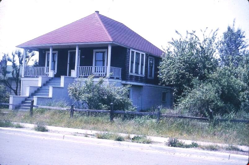
- Photograph of the northeast portion of the Coe family house at 2684 (renumbered in the 6300 block) Fern Avenue. The house is two stories high with front steps that lead up to a large veranda.
- Repository
- Burnaby Village Museum
- Collection/Fonds
- Burnaby Village Museum Photograph collection
- Description Level
- Item
- Physical Description
- 1 photograph : col. slide (Kodachrome) ; 2.5 x 3.5 cm
- Scope and Content
- Photograph of the northeast portion of the Coe family house at 2684 (renumbered in the 6300 block) Fern Avenue. The house is two stories high with front steps that lead up to a large veranda.
- Subjects
- Buildings - Residential - Houses
- Geographic Access
- Fern Avenue
- Accession Code
- BV995.13.2
- Access Restriction
- Restricted access
- Reproduction Restriction
- May be restricted by third party rights
- Date
- July 1965
- Media Type
- Photograph
- Historic Neighbourhood
- Central Park (Historic Neighbourhood)
- Planning Study Area
- Marlborough Area
- Scan Resolution
- 600
- Scan Date
- 01-Jun-09
- Scale
- 100
- Notes
- Title based on contents of photograph
- Note on recto of slide mount reads: "COE Residence/ North East View / Fern Ave Burnaby"
- Date stamp on recto of slide mount reads: "JUL 65V."
Images
Coe family house
https://search.heritageburnaby.ca/link/museumdescription3131
- Repository
- Burnaby Village Museum
- Date
- July 1965
- Collection/Fonds
- Burnaby Village Museum Photograph collection
- Description Level
- Item
- Physical Description
- 1 photograph : col. slide (Kodachrome) ; 2.5 x 3.5 cm
- Scope and Content
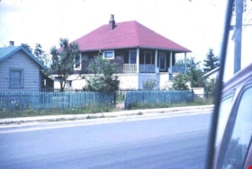
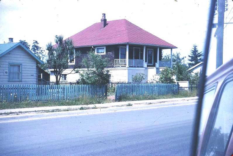
- Photograph of the southeast portion of the Coe family house at 2684 (renumbered in the 6300 block) Fern Avenue. The house is two stories high with front steps that lead up to a large veranda.
- Repository
- Burnaby Village Museum
- Collection/Fonds
- Burnaby Village Museum Photograph collection
- Description Level
- Item
- Physical Description
- 1 photograph : col. slide (Kodachrome) ; 2.5 x 3.5 cm
- Scope and Content
- Photograph of the southeast portion of the Coe family house at 2684 (renumbered in the 6300 block) Fern Avenue. The house is two stories high with front steps that lead up to a large veranda.
- Subjects
- Buildings - Residential - Houses
- Geographic Access
- Fern Avenue
- Accession Code
- BV995.13.3
- Access Restriction
- Restricted access
- Reproduction Restriction
- May be restricted by third party rights
- Date
- July 1965
- Media Type
- Photograph
- Historic Neighbourhood
- Central Park (Historic Neighbourhood)
- Planning Study Area
- Marlborough Area
- Scan Resolution
- 600
- Scan Date
- 01-Jun-09
- Scale
- 100
- Notes
- Title based on contents of photograph
- Note on recto of slide mount reads: "COE Residence/ South East View / Fern Ave Burnaby"
- Date stamp on recto of slide mount reads: "JUL 65V."
Images

Coe family house
https://search.heritageburnaby.ca/link/museumdescription3132
- Repository
- Burnaby Village Museum
- Date
- July 1965
- Collection/Fonds
- Burnaby Village Museum Photograph collection
- Description Level
- Item
- Physical Description
- 1 photograph : col. slide (Kodachrome) ; 2.5 x 3.5 cm
- Scope and Content
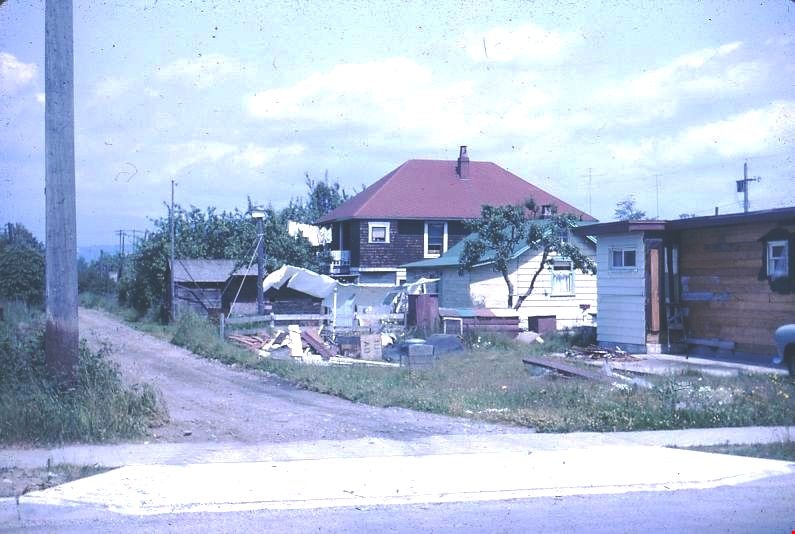
- Photograph of the southwest portion of the Coe family house at 2684 (renumbered in the 6300 block) Fern Avenue. The house is two stories high with front steps that lead up to a large veranda.
- Repository
- Burnaby Village Museum
- Collection/Fonds
- Burnaby Village Museum Photograph collection
- Description Level
- Item
- Physical Description
- 1 photograph : col. slide (Kodachrome) ; 2.5 x 3.5 cm
- Scope and Content
- Photograph of the southwest portion of the Coe family house at 2684 (renumbered in the 6300 block) Fern Avenue. The house is two stories high with front steps that lead up to a large veranda.
- Subjects
- Buildings - Residential - Houses
- Geographic Access
- Fern Avenue
- Accession Code
- BV995.13.4
- Access Restriction
- Restricted access
- Reproduction Restriction
- May be restricted by third party rights
- Date
- July 1965
- Media Type
- Photograph
- Historic Neighbourhood
- Central Park (Historic Neighbourhood)
- Planning Study Area
- Marlborough Area
- Scan Resolution
- 600
- Scan Date
- 01-Jun-09
- Scale
- 100
- Notes
- Title based on contents of photograph
- Note on recto of slide mount reads: "COE Residence/ South West View / Fern Ave Burnaby"
- Date stamp on recto of slide mount reads: "JUL 65V."
Images
![Eric Coe, [193-] thumbnail](/media/hpo/_Data/_BVM_Images/2000/200100010346.jpg?width=280)
Eric Coe
https://search.heritageburnaby.ca/link/museumdescription1642
- Repository
- Burnaby Village Museum
- Date
- [193-]
- Collection/Fonds
- Burnaby Village Museum Photograph collection
- Description Level
- Item
- Physical Description
- 1 photograph : b&w ; 15 x 9 cm print
- Scope and Content
- Photograph of Eric Coe standing in a grassy lane behind Fern Avenue, dressed in an overcoat and hat. To his right is "Bradshaw's greenhouse" on Fern Avenue and "Captain Gillen's house" is partially visible in the background.
- Repository
- Burnaby Village Museum
- Collection/Fonds
- Burnaby Village Museum Photograph collection
- Description Level
- Item
- Physical Description
- 1 photograph : b&w ; 15 x 9 cm print
- Scope and Content
- Photograph of Eric Coe standing in a grassy lane behind Fern Avenue, dressed in an overcoat and hat. To his right is "Bradshaw's greenhouse" on Fern Avenue and "Captain Gillen's house" is partially visible in the background.
- History
- Captain Gillen is William Hugh Gillen, father of Denver Gillen, original illustrator of the 1936 sensation "Rudolph the Red Nosed Reindeer". The house stood at 2718 Nelson Avenue.
- Subjects
- Geographic Features - Lanes
- Names
- Coe, Eric
- Geographic Access
- Fern Avenue
- Accession Code
- BV001.1.346
- Access Restriction
- No restrictions
- Date
- [193-]
- Media Type
- Photograph
- Historic Neighbourhood
- Central Park (Historic Neighbourhood)
- Planning Study Area
- Marlborough Area
- Scan Resolution
- 600
- Scan Date
- 09-Jun-09
- Scale
- 100
- Notes
- Title based on contents of photograph
Images
![Eric Coe, [193-] thumbnail](/media/hpo/_Data/_BVM_Images/2000/200100010346.jpg)
![Minnie Coe and Evelyn Condio, [between 1910 and 1929] thumbnail](/media/hpo/_Data/_BVM_Images/2000/200100010347.jpg?width=280)
Minnie Coe and Evelyn Condio
https://search.heritageburnaby.ca/link/museumdescription1643
- Repository
- Burnaby Village Museum
- Date
- [between 1910 and 1929]
- Collection/Fonds
- Burnaby Village Museum Photograph collection
- Description Level
- Item
- Physical Description
- 1 photograph : sepia ; 14 x 8 cm
- Scope and Content
- Photograph of cousins Mignon (Minnie) Coe and Evelyn Condio standing together in front of the arbour at the Coe family residence at 2684 Fern Avenue (renumbered in the 6300 block). Mignon Coe (later Uter) was the daughter of Elizabeth and James Coe.
- Repository
- Burnaby Village Museum
- Collection/Fonds
- Burnaby Village Museum Photograph collection
- Description Level
- Item
- Physical Description
- 1 photograph : sepia ; 14 x 8 cm
- Scope and Content
- Photograph of cousins Mignon (Minnie) Coe and Evelyn Condio standing together in front of the arbour at the Coe family residence at 2684 Fern Avenue (renumbered in the 6300 block). Mignon Coe (later Uter) was the daughter of Elizabeth and James Coe.
- Geographic Access
- Fern Avenue
- Accession Code
- BV001.1.347
- Access Restriction
- No restrictions
- Date
- [between 1910 and 1929]
- Media Type
- Photograph
- Historic Neighbourhood
- Central Park (Historic Neighbourhood)
- Planning Study Area
- Marlborough Area
- Scan Resolution
- 600
- Scan Date
- 09-Jun-09
- Scale
- 100
- Notes
- Title based on contents of photograph
- Note in pencil on verso of photograph reads: "Minnie Coe + Evelyn Condio cousin"
Images
![Minnie Coe and Evelyn Condio, [between 1910 and 1929] thumbnail](/media/hpo/_Data/_BVM_Images/2000/200100010347.jpg)
![Survey and Subdivision plans in New Westminster District Group 1 – Burnaby, [1905-1917] thumbnail](/media/hpo/_Data/_BVM_Cartographic_Material/1977/1977_0093_0022a_001.jpg?width=280)
Survey and Subdivision plans in New Westminster District Group 1 – Burnaby
https://search.heritageburnaby.ca/link/museumdescription6991
- Repository
- Burnaby Village Museum
- Date
- [1905-1917]
- Collection/Fonds
- Burnaby Village Museum Map collection
- Description Level
- File
- Physical Description
- 12 plans : 6 black ink on paper + 2 black & col. ink on paper + 4 graphite on paper
- Scope and Content
- Item consists of a large board of six New Westminster District subdivision plans mounted on one side and six New Westminster District subdivision plans mounted on the other side. Side A: 1. Plan drawn in graphite with markings in black ink "Surveyed for Mr. W. Wilson / Paterson Stat. B.C.E.R." . …
- Repository
- Burnaby Village Museum
- Collection/Fonds
- Burnaby Village Museum Map collection
- Description Level
- File
- Physical Description
- 12 plans : 6 black ink on paper + 2 black & col. ink on paper + 4 graphite on paper
- Material Details
- Scales [between 1:360 and 1:3168]
- Index number on edge of board reads: "22"
- Scope and Content
- Item consists of a large board of six New Westminster District subdivision plans mounted on one side and six New Westminster District subdivision plans mounted on the other side. Side A: 1. Plan drawn in graphite with markings in black ink "Surveyed for Mr. W. Wilson / Paterson Stat. B.C.E.R." . Plan includes subdivision of lots situated between B.C.E. Railway and Vancouver Road (Kingsway). (Geographic location: Burnaby) 2. Subdivision plan (no title) drawn in black ink with annotations in graphite. Plan covers District Lots 2, 4 and 6, west of North Road. Plan is stamped: "Albert J. Hill, Civil Engineer / and / Provincial Land Surveyor, / New Westminster, / B.C. (Geographic location: Burnaby) 3. Plan of "Portion of Municipality" with intials "RB" [sic] (handwritten in blue crayon). Plan covers the area north east of the City of New Westminster including District Lots 11, 13, 14, 12, 1 and 2. Plan is stamped: "Albert J. Hill, Civil Engineer / and / Provincial Land Surveyor, / New Westminster, / B.C. (Geographic location: Burnaby) 4."Plan / of Subdivision of / N.W.1/4 Lot 175 / Group 1 New West. Dist. / B.C. / Scale 4 chs = 1 in. " Plan is stamped: "Albert J. Hill, Civil Engineer / and / Provincial Land Surveyor, / New Westminster, / B.C. and initialed : "RB" [sic] (in blue pencil crayon) (Geographic location: Burnaby) 5. "Subdivision / of a Portion of / Lot 15 Group 1 / New Westminster Dist. / Scale 4 chs = 1 in". Plan provides numbered sudivisions - Lots 1 to 15 of District Lot 15 in red ink. (Geographic location: Burnaby) 6. Plan of "Central Park & / Vicinity" Plan includes subdivisions of District Lot 153 east of Central Park District Lot 151 and subdivision of District Lot 36 and 49 west of Boundary Road (Vancouver). Plan is stamped: "Albert J. Hill, Civil Engineer / and / Provincial Land Surveyor, / New Westminster, / B.C. and initialed : "RB" [sic] (in blue pencil crayon). (Geographic location: Burnaby) Side B: 1. Subdivision plan (no title) drawn in black ink. Plan identifies lots between Vancouver Road (Yale Road is crossed out and replaced with Vancouver Road) and B.C.E. Railway. "Scale 2 chs = 1 in" (Geographic location: Burnaby) 2. Plan of "Subdivision Lot 1 / Lot 69 Gr. 1 / Scale 30' = 1 " " Plan identifies Boundary Road, Still Creek and a Road Allowance between District Lot 118 and District Lot 69. Plan was "Surveyed for Burnaby Mun. Council / March 11th 1908 / G.K.B." (Geographic location: Burnaby) 3. Plan drawn in black ink (no title) showing a subdivision in Lot 25 with names "Newcomb", "Debeck" and "Armstrong" along with roads identified as Third Street, Cumberland Street, Armstrong Street and Cariboo [sic] Street and including Lots 27, 11 and 13.Plan is stamped: "Albert J. Hill, Civil Engineer / and / Provincial Land Surveyor, / New Westminster, / B.C. and initialed : "RB" [sic] (in blue pencil crayon). (Geographic location: Burnaby) 4. Handrawn subdivision plan in graphite titled: "Lot 13, Gr.1" with intials "RB" [sic] (handwritten in blue crayon). Plan is bordered by Armstrong Street (Lot 11, G.1), Cumberland St. (Lot 25, G.1) and Tenth Avenue (City Boundary). The plan is singed by "Albert J. Hill / P.L.S." and one of the subdivided lots is identified with the name: "W. Karrymann". (Geographic location: Burnaby) 5. Handrawn sketch in graphite titled: "Lot 88, Gr.1" with intials "RB" [sic] (handwritten in blue crayon). Plan appears to be a draft of a subdivision plan of a portion of District Lot 88 along Cumberland Road. The plan is signed: "16/7/17 _W.F. Draper [sic] / B.C.L.S." (Geographic location: Burnaby) 6. "Plan / of Subdivision / of Blocks 61, 62 and 2 / Lot 30 / Group 1 / N.W. Dist. / Scale 1ch = 1 in". Plan is intialed by: "PB" with a note: "Also see board 2 / for duplicate" (handwritten in blue crayon). (Geographic location: Burnaby)
- Creator
- Hill, Albert James
- Geographic Access
- Boundary Road
- Kingsway
- Cumberland Street
- Accession Code
- HV977.93.22
- Access Restriction
- No restrictions
- Reproduction Restriction
- No known restrictions
- Date
- [1905-1917]
- Media Type
- Cartographic Material
- Historic Neighbourhood
- Central Park (Historic Neighbourhood)
- Scan Resolution
- 300
- Scale
- 100
- Notes
- Title based on contents of file
- Scale is measured in chains and feet. (One chain equals 792 inches)
- The term "Lot" can also refer to a "District Lot”
- Some plans are stamped: "Albert J. Hill, Civil Engineer / and / Provincial Land Surveyor, / New Westminster, / B.C." and intialed: "RB" [sic]
Images
![Survey and Subdivision plans in New Westminster District Group 1 – Burnaby, [1905-1917] thumbnail](/media/hpo/_Data/_BVM_Cartographic_Material/1977/1977_0093_0022a_001.jpg)
