Narrow Results By
Subject
- Advertising Medium - Signs and Signboards 1
- Aerial Photographs 2
- Animals - Dogs 3
- Animals - Horses 1
- Buildings 1
- Buildings - Civic 1
- Buildings - Civic - Fire Halls 1
- Buildings - Commercial 2
- Buildings - Commercial - Drive-In Theatres 1
- Buildings - Commercial - Hotels and Motels 2
- Buildings - Commercial - Malls 1
- Buildings - Commercial - Restaurants 1

Central Park Neighbourhood
https://search.heritageburnaby.ca/link/landmark723
- Repository
- Burnaby Heritage Planning
- Associated Dates
- 1891-1904
- Heritage Value
- Central Park was one of the first and fastest-growing communities in Burnaby. Located along the electric tram line and the Vancouver Road (Kingsway), it was also chosen for a government settlement project referred to as the Central Park Small Holdings. The lands held by the Provincial Government were subdivided and sold around 1894 and by 1899 the settlement was large enough to warrant the construction of an Anglican Church there.
- Historic Neighbourhood
- Central Park (Historic Neighbourhood)
- Planning Study Area
- Maywood Area
Images


Garden Village Neighbourhood
https://search.heritageburnaby.ca/link/landmark800
- Repository
- Burnaby Heritage Planning
- Associated Dates
- 1955-2008
- Heritage Value
- Bounded by Moscrop Street to the north, Kingsway and Grange to the south, Willingdon to the east and Boundary Road to the west, the Garden Village Neighbourhood is characterised as a primarily residential area that is well-served due to its proximity to commercial, park and business centres. The north-east corner of the neighbourhood is a typical 1950s subdivision of mostly single family homes located on an irregular street pattern, while the remaining areas saw some transition to multi-family housing types throughout the 1970s and up to the current time.
- Historic Neighbourhood
- Central Park (Historic Neighbourhood)
- Planning Study Area
- Garden Village Area
Images


Maywood Neighbourhood
https://search.heritageburnaby.ca/link/landmark801
- Repository
- Burnaby Heritage Planning
- Associated Dates
- 1955-2008
- Heritage Value
- Burnaby's Maywood Neighbourhood consists of the Metrotown Town Centre - one of four Town Centres in the City. Metrotown is one of the region's most developed and fastest growing centres. It is served by the first SkyTrain line developed in the mid-1980s and anchored by B.C.'s largest shopping and entertainment complex. As an older centre that has progressively added new developments over the years, Metrotown offers a range of housing types and tenures from three-storey walk-up apartments to modern residential towers.
- Historic Neighbourhood
- Central Park (Historic Neighbourhood)
- Planning Study Area
- Maywood Area
Images


Marlborough Neighbourhood
https://search.heritageburnaby.ca/link/landmark802
- Repository
- Burnaby Heritage Planning
- Associated Dates
- 1955-2008
- Heritage Value
- The Marlborough Neighbourhood is another residential area that was witness to rapid growth and subdivision during the 1950s and 1960s, creating primarily single-family housing stock. In the 1970s and 1980s, as the commercial district around Kingsway grew, so too did higher density housing projects such as townhomes and condominiums.
- Historic Neighbourhood
- Central Park (Historic Neighbourhood)
- Planning Study Area
- Marlborough Area
Images


Oakalla Neighbourhood
https://search.heritageburnaby.ca/link/landmark804
- Repository
- Burnaby Heritage Planning
- Associated Dates
- 1955-2008
- Heritage Value
- The phasing out and demolition of the Oakalla Prison farm allowed for the planned development of the Oakalla Neighbourhood in the 1980s. By 1991, the City of Burnaby had adopted the Oakalla Development Plan which called for the transfer of land to the Deer Lake Park reserve as well as the creation of a new residential area consisting of multi-family housing types.
- Historic Neighbourhood
- Central Park (Historic Neighbourhood)
- Planning Study Area
- Oakalla Area
Images

![Central Park siding of Westminster and Vancouver Tramway Co., [between 1891 and 1894] thumbnail](/media/hpo/_Data/_BVM_Images/2021/2021_0029_0001_001.jpg?width=280)
Central Park siding of Westminster and Vancouver Tramway Co.
https://search.heritageburnaby.ca/link/museumdescription17430
- Repository
- Burnaby Village Museum
- Date
- [between 1891 and 1894]
- Collection/Fonds
- Burnaby Village Museum Photograph collection
- Description Level
- Item
- Physical Description
- 1 photograph : b&w albumen print on card ; 20 x 25 cm
- Scope and Content
- Photograph of two streetcars at the Central Park siding of Westminster and Vancouver Tramway Co. Conductors, engineers and riders are posing with the streetcars. The fronts of the streetcars include painted signage reading "12" and "13" and the sides of the streetcars read "WESTMINSTER AND VANCOUVE…
- Repository
- Burnaby Village Museum
- Collection/Fonds
- Burnaby Village Museum Photograph collection
- Description Level
- Item
- Physical Description
- 1 photograph : b&w albumen print on card ; 20 x 25 cm
- Scope and Content
- Photograph of two streetcars at the Central Park siding of Westminster and Vancouver Tramway Co. Conductors, engineers and riders are posing with the streetcars. The fronts of the streetcars include painted signage reading "12" and "13" and the sides of the streetcars read "WESTMINSTER AND VANCOUVER TRAMWAY CO. LTD.".
- History
- Photographers Richard H. Trueman and Norman Caple operated out of Vancouver between 1891 and 1894. The photographers worked between Winnipeg and the west coast of Canada specializing in mountain and railway views, ranch scenes and Indigenous peoples. In 1890, two companies started building electric rail; the Westminster and Vancouver Tramway Co., which undertook the ambitious project of building the first real interurban line from New Westminster to Vancouver, and the Westminster Street Railway. By April 20, 1891, both companies merged to form the Westminster and Vancouver Tramway Company. Streetcar service began in June 1891, travelling on twelve miles of track between New Westminster and eastern Vancouver and running through Burnaby. The line was taken over by the B.C. Electric Railway Company in 1897 until the line was closed in October 1953.
- Accession Code
- BV021.29.1
- Access Restriction
- No restrictions
- Reproduction Restriction
- No known restrictions
- Date
- [between 1891 and 1894]
- Media Type
- Photograph
- Historic Neighbourhood
- Central Park (Historic Neighbourhood)
- Planning Study Area
- Maywood Area
- Scan Resolution
- 600
- Scan Date
- 2021-09-24
- Scale
- 100
- Photographer
- Trueman & Caple
- Notes
- Title taken from recto of photograph
- Inscription on recto of photograph reads: "1138_Central Parkk Sideing of Westminster and Vancouver Tramway Co. _Trueman and Caple. Photo. Vancouver B.C."
- Inscription in gold ink on board reads: "Trueman & Caple_Vancouver, B.C."
Images
![Central Park siding of Westminster and Vancouver Tramway Co., [between 1891 and 1894] thumbnail](/media/hpo/_Data/_BVM_Images/2021/2021_0029_0001_001.jpg)

Royal Oak Hotel
https://search.heritageburnaby.ca/link/landmark726
- Repository
- Burnaby Heritage Planning
- Geographic Access
- Kingsway
- Associated Dates
- 1891
- Heritage Value
- One of the most notorious landmarks in Burnaby was the Royal Oak Hotel, constructed around 1891 at the present-day northeast corner of Kingsway and Royal Oak. Levis Morrison built the hotel, then sold out to Charles Cridland, whose poor hotel reputation prompted Burnaby council to hire its second police constable. The hotel continued to operate until 1973 when it was demolished to build a Safeway store.
- Historic Neighbourhood
- Central Park (Historic Neighbourhood)
- Planning Study Area
- Marlborough Area
- Street View URL
- Google Maps Street View
Images


Central Park
https://search.heritageburnaby.ca/link/landmark728
- Repository
- Burnaby Heritage Planning
- Geographic Access
- Imperial Street
- Associated Dates
- 1891
- Heritage Value
- In 1860, as the Royal Engineers constructed the road from New Westminster to Vancouver (now Kingsway), a military reserve was set aside at the trail's highest point along the ridge. This reserve provided a particularly good scenic look-out since the original forest had burned down prior to 1860, the remaining stumps offered unobstructed views. By the 1880s, the city council of both New Westminster and Vancouver eyed the reserve as potential recreation ground. As construction of the tram line was underway, the Provincial Government moved to designate the whole reserve as a park. On January 14, 1891, the Lieutenant Governor of British Columbia proclaimed it as a public recreation ground.
- Historic Neighbourhood
- Central Park (Historic Neighbourhood)
- Planning Study Area
- Maywood Area
- Street Address
- 3883 Imperial Street
- Street View URL
- Google Maps Street View
Images


Central Park Tramline
https://search.heritageburnaby.ca/link/landmark732
- Repository
- Burnaby Heritage Planning
- Associated Dates
- 1891
- Heritage Value
- In the 1890s, local entrepreneurs launched electric railways in Vancouver, New Westminster, and Victoria, eager to cash in on the promise of future growth in the major cities of the time. In the Lower Mainland, two companies started building electric rail in 1890: the Westminster and Vancouver Tramway Co., which undertook the ambitious project of building the first real interurban line from New Westminster to Vancouver, and the Westminster Street Railway, who eventually built streetcar service and installed electric lighting in New Westminster. By April 20, 1891, both companies merged to form the Westminster and Vancouver Tramway Company. Local entrepreneurs Henry V. Edmonds, David Oppenheimer, Benjamin Douglas, and Samuel McIntosh, were the directors, all of whom had extensive real estate holdings in the area. Interurban service launched on June 3, 1891, travelling along 12 miles of track from New Westminster to eastern Vancouver, running through Burnaby – which was then an unincorporated area. Installing the single-track line from Vancouver to New Westminster through uneven, forested terrain was a mammoth undertaking. The clearing of the 100-foot right of way and laying the track called for a large work force, some of whom were Chinese "gandy dancers" who had worked on the Canadian Pacific Railway lines. The line was eventually taken over by the B.C. Electric Railway Company in 1897, who remained the owners until the line was finally closed on October 23, 1953 and replaced with the modern bus system. The construction of the SkyTrain along the old route in 1986 reintroduced passenger rail to this historic transportation corridor.
- Historic Neighbourhood
- Central Park (Historic Neighbourhood)
- Planning Study Area
- Maywood Area
Images


West Burnaby School (aka Kingsway West School)
https://search.heritageburnaby.ca/link/landmark727
- Repository
- Burnaby Heritage Planning
- Geographic Access
- Kingsway
- Associated Dates
- 1896
- Heritage Value
- West Burnaby School was to be Burnaby's second public school and it served the children who lived along the tram line and Vancouver Road (Kingsway).
- Historic Neighbourhood
- Central Park (Historic Neighbourhood)
- Planning Study Area
- Maywood Area
- Street View URL
- Google Maps Street View
Images


Central Park Presbyterian Church
https://search.heritageburnaby.ca/link/archivedescription36673
- Repository
- City of Burnaby Archives
- Date
- 1896 (date of original), copied 1992
- Collection/Fonds
- Burnaby Historical Society fonds
- Description Level
- Item
- Physical Description
- 1 photograph : b&w ; 10.1 x 14.9 cm print
- Scope and Content
- Photograph of the exterior of Central Park Presbyterian Church. Typed note at the bottom of the photograph reads, "The Original Presbyterian Church on Westminster Road at Central Park as in approx. 1896. Burned down and rebuilt. Mrs. P. Oben."
- Repository
- City of Burnaby Archives
- Date
- 1896 (date of original), copied 1992
- Collection/Fonds
- Burnaby Historical Society fonds
- Subseries
- Burnaby Centennial Anthology subseries
- Physical Description
- 1 photograph : b&w ; 10.1 x 14.9 cm print
- Description Level
- Item
- Record No.
- 315-028
- Access Restriction
- No restrictions
- Reproduction Restriction
- No known restrictions
- Accession Number
- BHS1994-04
- Scope and Content
- Photograph of the exterior of Central Park Presbyterian Church. Typed note at the bottom of the photograph reads, "The Original Presbyterian Church on Westminster Road at Central Park as in approx. 1896. Burned down and rebuilt. Mrs. P. Oben."
- Subjects
- Buildings - Religious - Churches
- Media Type
- Photograph
- Notes
- Title based on contents of photograph
- Geographic Access
- Westminster Avenue
- Kingsway
- Street Address
- 3777 Kingsway
- Historic Neighbourhood
- Central Park (Historic Neighbourhood)
- Planning Study Area
- Garden Village Area
Images

West Burnaby School class
https://search.heritageburnaby.ca/link/archivedescription36019
- Repository
- City of Burnaby Archives
- Date
- 1898
- Collection/Fonds
- Burnaby Historical Society fonds
- Description Level
- Item
- Physical Description
- 1 photograph : sepia ; 19.5 x 24 cm, mounted on board 25 x 30 cm
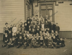
- Scope and Content
- Photograph of the West Burnaby School class, including teachers, lined up in rows on the porch steps, with the first row seated on the ground with their feet crossed in front of them. Individuals that have been identified, in pencil, directly on the photograph include; Teacher Lili Lawson (far left…
- Repository
- City of Burnaby Archives
- Date
- 1898
- Collection/Fonds
- Burnaby Historical Society fonds
- Subseries
- Patterson family subseries
- Physical Description
- 1 photograph : sepia ; 19.5 x 24 cm, mounted on board 25 x 30 cm
- Description Level
- Item
- Record No.
- 213-001
- Access Restriction
- No restrictions
- Reproduction Restriction
- No known restrictions
- Accession Number
- BHS1988-13
- Scope and Content
- Photograph of the West Burnaby School class, including teachers, lined up in rows on the porch steps, with the first row seated on the ground with their feet crossed in front of them. Individuals that have been identified, in pencil, directly on the photograph include; Teacher Lili Lawson (far left), Lily Main (two over from Lawson), Ethel Smith (far left in the back row), and Headmaster Samuel Shepard (far right in the back row). Members of the Patterson family are also in this photograph; William (Bill) is sitting in the front row, third from the left, Bruce is sitting two to the right of Bill, with Alice two rows directly behind Bruce (her hair is shorter than the other girls and she is wearing a dark shirt), with their older sister Mary standing two rows directly behind Alice. The school was later renamed Kingsway West School and remained in operations until 1952.
- Subjects
- Occupations - Teachers
- Media Type
- Photograph
- Notes
- Title based on contents of photograph
- Photographer identified as "Thompson"
- Geographic Access
- Kingsway
- Street Address
- 4800 Kingsway
- Historic Neighbourhood
- Central Park (Historic Neighbourhood)
- Planning Study Area
- Maywood Area
Images
![West Burnaby School, [1898] thumbnail](/media/hpo/_Data/_Archives_Images/_Unrestricted/251/297-001.jpg?width=280)
West Burnaby School
https://search.heritageburnaby.ca/link/archivedescription36571
- Repository
- City of Burnaby Archives
- Date
- [1898]
- Collection/Fonds
- Burnaby Historical Society fonds
- Description Level
- Item
- Physical Description
- 1 photograph : sepia ; 18.5 x 23.5 cm, mounted on board 21.5 x 25 cm + 1p. accompanying
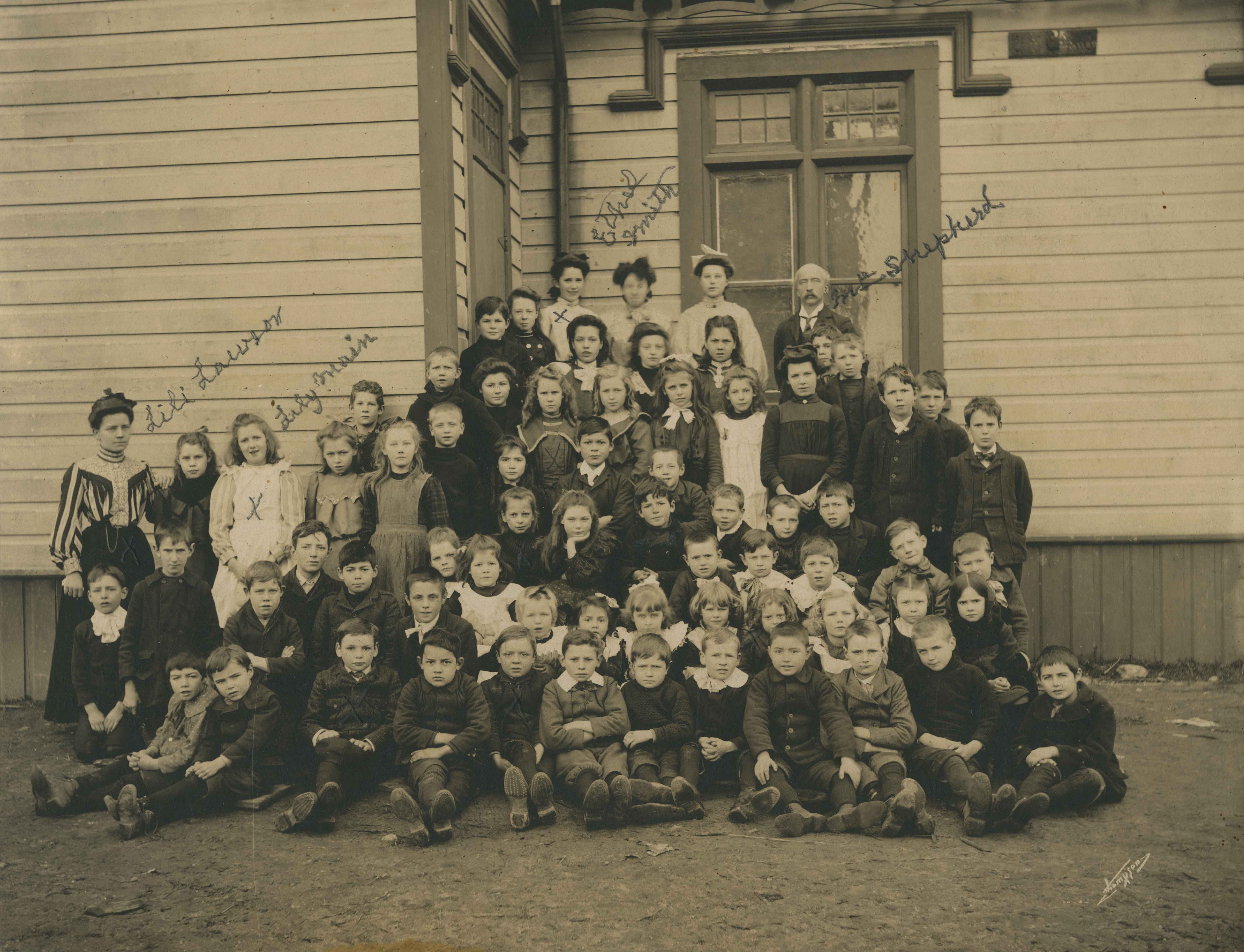
- Scope and Content
- Photograph of West Burnaby School students standing outside in front of their school in two long rows, with their teacher and school staff members standing on the right. Daisy Birchell is the smallest in the group, standing in the front row, eighth from the left, and her cousin is standing beside h…
- Repository
- City of Burnaby Archives
- Date
- [1898]
- Collection/Fonds
- Burnaby Historical Society fonds
- Subseries
- Photographs subseries
- Physical Description
- 1 photograph : sepia ; 18.5 x 23.5 cm, mounted on board 21.5 x 25 cm + 1p. accompanying
- Description Level
- Item
- Record No.
- 297-001
- Access Restriction
- No restrictions
- Reproduction Restriction
- No known restrictions
- Accession Number
- BHS1992-37
- Scope and Content
- Photograph of West Burnaby School students standing outside in front of their school in two long rows, with their teacher and school staff members standing on the right. Daisy Birchell is the smallest in the group, standing in the front row, eighth from the left, and her cousin is standing beside her, ninth from the left. The school was later renamed Kingsway West School and remained in operations until 1952.
- Subjects
- Buildings - Schools
- Media Type
- Photograph
- Notes
- Title based on contents of photograph
- Note in accompanying material states that the photograph is the property of Charles Burchell's family, and "children as pupils" were; William, Frederick, Lily, and Daisy Burchell.
- Geographic Access
- Kingsway
- Street Address
- 4800 Kingsway
- Historic Neighbourhood
- Central Park (Historic Neighbourhood)
- Planning Study Area
- Maywood Area
Images
![West Burnaby School, [1898] thumbnail](/media/hpo/_Data/_Archives_Images/_Unrestricted/251/297-001.jpg)
West Burnaby School class outside
https://search.heritageburnaby.ca/link/archivedescription37334
- Repository
- City of Burnaby Archives
- Date
- 1898
- Collection/Fonds
- Burnaby Historical Society fonds
- Description Level
- Item
- Physical Description
- 1 photograph : sepia ; 20.5 x 25.3 cm on 30.5 x 37.5 cm mat
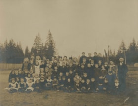
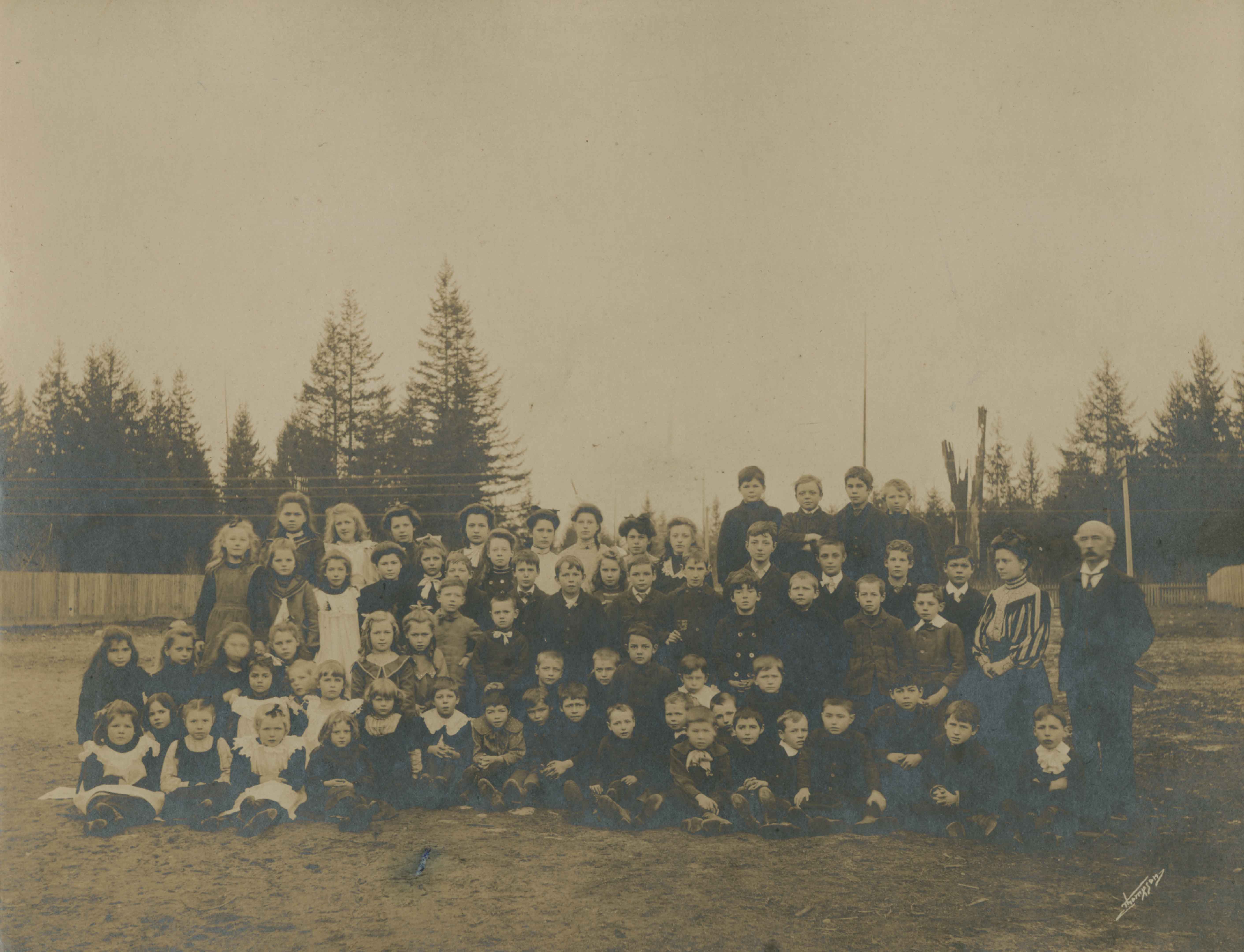
- Scope and Content
- Photograph of the West Burnaby School class, including teachers, on the dirt field next to the school. Eight of the individuals have been identified; sitting in the second row, second from the left is (8) Alice Patterson, standing in the center of the third row is (4) William (Bill) Pattterson, and…
- Repository
- City of Burnaby Archives
- Date
- 1898
- Collection/Fonds
- Burnaby Historical Society fonds
- Subseries
- Millway family subseries
- Physical Description
- 1 photograph : sepia ; 20.5 x 25.3 cm on 30.5 x 37.5 cm mat
- Description Level
- Item
- Record No.
- 353-001
- Access Restriction
- No restrictions
- Reproduction Restriction
- No known restrictions
- Accession Number
- BHS1997-12
- Scope and Content
- Photograph of the West Burnaby School class, including teachers, on the dirt field next to the school. Eight of the individuals have been identified; sitting in the second row, second from the left is (8) Alice Patterson, standing in the center of the third row is (4) William (Bill) Pattterson, and in the back row on the far left is (7) Mary Patterson, beside her, (6) Lily Main, three from Lily is (5)Ethel Smith, and third from the right in the same row is (3) Bruce Patterson. The school headmaster (1) Samuel Shepard is standing on the far right and standing next to him is their teacher, (2) Lily Smith. The school was later renamed Kingsway West School and remained in operations until 1952.
- Subjects
- Occupations - Teachers
- Names
- Kingsway West School
- Media Type
- Photograph
- Notes
- Title based on contents of photograph
- Photographer identified as "Thompson"
- Geographic Access
- Kingsway
- Street Address
- 4800 Kingsway
- Historic Neighbourhood
- Central Park (Historic Neighbourhood)
- Planning Study Area
- Maywood Area
Images
![Burnaby Girl Guides, [1914]-1969, predominant ca. 1920 (date of original), copied 2016 thumbnail](/media/hpo/_Data/_BVM_Images/2015/2015_0035_0164_folded.jpg?width=280)
Burnaby Girl Guides
https://search.heritageburnaby.ca/link/museumdescription4592
- Repository
- Burnaby Village Museum
- Date
- [1914]-1969, predominant ca. 1920 (date of original), copied 2016
- Collection/Fonds
- Burnaby Girl Guides fonds
- Description Level
- File
- Physical Description
- 1 scrapbook (textual records + 2 digital files : (pdfs) + 102 photographs : (tiffs))
- Scope and Content
- File consists of images and selected contents from a scrapbook with 38 double sided pages containing mostly photographs with some newspaper clippings, written material and emphemera including a page of badges and ribbons which reads "Enrolment & Membership Card of / Joan Bailey 1926 / 1st Burnaby" …
- Repository
- Burnaby Village Museum
- Collection/Fonds
- Burnaby Girl Guides fonds
- Description Level
- File
- Physical Description
- 1 scrapbook (textual records + 2 digital files : (pdfs) + 102 photographs : (tiffs))
- Scope and Content
- File consists of images and selected contents from a scrapbook with 38 double sided pages containing mostly photographs with some newspaper clippings, written material and emphemera including a page of badges and ribbons which reads "Enrolment & Membership Card of / Joan Bailey 1926 / 1st Burnaby" and an embroidered alphabet of the Morse Code. The third page of the scrapbook includes a four page chronology titled "History of Guiding - Burnaby / 1913 - 1960" compiled by Mrs. Dolly Weber, Mrs. J. Heaps, Miss Eileen Periton, Mrs. J. Albertson and D. Fowler. The scrapbook also includes an original letter and post-script from Lady Olave Baden-Powell to Mrs. Fowler dated November 5, 1961; a typewritten copy of: "TSOONA" / PROVINCIAL GUIDE CAMPSITE - ROSEDALE B.C." and a three page typewritten copy of "THE CAMPFIRE / Volume 1, No. 4 _ November 1935 _ Vancouver, B.C.". Many of the events documented in photographs [between 1914 and 1969] are identified on each page and read as the following: "Burnaby Brownies - Guides & Rangers" / "Early 1920" (1 photograph); "Ambulance / Display / 1st. Co."; "Girl Guide Rally - New Westminster and / Burnaby - June 16, 1923" (5 photographs); "Girl Guide Rally - New Westminster and / Burnaby - June 16, 1923" (5 photographs); "Burnaby Guides and / Brownies / June 17, 1923" (5 photographs); "April 1923" (1 photograph); "June 1923 / 2nd Burnaby Company" (1 photograph); "Burnaby May Day / 26.5.28"(2 photographs); "Sechelt 1929_ 2nd "B" Company" (2 photographs); "Leaders and Seconds / 2nd Burnaby / Grouse Mountain" (1 photograph); "Sechelt 1929 / Commandant Mrs. Peal" (1 photograph); "2nd Company / June 1930" (1 photograph); "1932 / 2nd Company at Rally / Municipal Hall Grounds" (1 photograph) ; "First Burnaby Folk Dancing team / Winners of the E.F.D. cup 1940--41-42" (1 photograph); "1st Burnaby Company / winners of Bessborough Shield / 1942 / Captain L. Crane" (1 photograph); "May 6th 1935 / Dedication of flag at Central Park" (1 photograph); "May Day Celebration / Burnaby B.C. May 6th 1935 / Stride Studios Photos" (1 photograph); "Mrs. Don Wilks / Mrs. Georgie / Runcie / Publicity Photo re- / Brownie / Training / 1958-60" (1 photograph); "Kathleen Anderson / about 1958-60?" (1 photograph); "1957 / Burnaby Camp Site / at / Wilson Creek" (1 photograph); "Work Party (1958)" (1 photograph); "Burnaby Camp Site / Spring 1958 / Cabins & Staff Houses / Dining Shelter / Cabins" (3 photographs); "Can. Girl Guide Assoc. - Provincial Leaders Conference / April 14-15/61 Civic Centre, Prince George, BC" (1 photograph) ; "June 8th, 1958 / Opening / Ceremonies / Burnaby Site / Wilson Creek / Camp Site" (4 photographs); 2 unidentified photographs [ca.1915] of a large group of Girl Guides gathered on the Pacific National Exhibition grounds (photo credit- Leonard Frank); 1 unidentified photograph of a group of Girl Guides gathered for a group portrait [ca.1914]; "Girl Guide Camp / Granthams / Landing / July 1923" (4 photographs); 4 unidentified photographs of girl guides gathered on the ship "Lady Evelyn" [ca. 1920]; "Burnaby Girl Guides" 1918; "First Burnaby Girl Guides 1920" (2 photographs on page); "2nd Co. 1923" (1 photograph) "1st Burnaby Co." [1923] (1 photograph); "Gypsy Scene - Concert / Mar 17, 1923 / Unveiling / War / Memorial / Edmonds / 1923" (3 photographs on page); "Faith Jacobson / 1961" (2 photographs); "Eve MacLean / 1961" (1 photograph); "Beverley Simkin of Montreal and Judy Robins / of the S.R.S. Royal Oak taken on the day they / sailed from Montreal for the Ranger Camp at / "Our Chalet" in Adelboden, Switzerland, May 1962" (1 photograph) and "Religion & Life Emblem / Diane Peters 11th Bby. Co. / Rev. G.W. Luetkehodeter / 1961" (2 photographs on one page).
- Names
- Girl Guides of Canada
- Accession Code
- BV015.35.164
- Access Restriction
- No restrictions
- Reproduction Restriction
- May be restricted by third party rights
- Date
- [1914]-1969, predominant ca. 1920 (date of original), copied 2016
- Media Type
- Photograph
- Textual Record
- Historic Neighbourhood
- Edmonds (Historic Neighbourhood)
- Central Park (Historic Neighbourhood)
- Planning Study Area
- Edmonds Area
- Maywood Area
- Notes
- Transcribed title
- Digital images were created of the scrapbook prior to selective retention of original records that were removed for conservation purposes
- Some textual records that were selected for retention have been described at file level under BV015.35.164: "Tsoona" Provincial Guide Campsite - Rosedale B.C." and Burnaby Girl Guides newsletter, "The Campfire" (November 1935)
- Photographs that were retained from scrapbook have been described at item level (BV015.35.221 to BV015.35.284)
- Some textual records and ephemera that were selected for retention have been described at item level (BV015.35.320, BV015.35.321, and BV015.35.334 to BV015.35.348).
Images
![Burnaby Girl Guides, [1914]-1969, predominant ca. 1920 (date of original), copied 2016 thumbnail](/media/hpo/_Data/_BVM_Images/2015/2015_0035_0164_folded.jpg)
Documents
Interview with Cice Brown, May 13, 2005 - Track 1
https://search.heritageburnaby.ca/link/museumdescription18947
- Repository
- Burnaby Village Museum
- Date
- 1930-1949 (interview content), interviewed May 13, 2005
- Collection/Fonds
- Burnaby Village Museum fonds
- Description Level
- Item
- Physical Description
- 1 sound recording (mp3) (0:07:37 min)
- Scope and Content
- Track 1: This portion of the recording pertains to Cice Brown talking about growing up in West Burnaby near Central Park, between West Burnaby and McKay tram station. Cice describes the area in which she lived; talks about attending school at Kingsway West and highschool at Burnaby South. Interview…
- Repository
- Burnaby Village Museum
- Collection/Fonds
- Burnaby Village Museum fonds
- Series
- Museum Oral Histories series
- Description Level
- Item
- Physical Description
- 1 sound recording (mp3) (0:07:37 min)
- Material Details
- Interviewer: Tom Gooden Interviewee: Cice Brown Date of interview: May 13, 2005 Total Number of Tracks: 7 Total length of all Tracks: 0:40:19
- Scope and Content
- Track 1: This portion of the recording pertains to Cice Brown talking about growing up in West Burnaby near Central Park, between West Burnaby and McKay tram station. Cice describes the area in which she lived; talks about attending school at Kingsway West and highschool at Burnaby South. Interviewer asks about the types of activities she was involved while growing up. Cice recalls being a member of the school choir at Kingsway West, the music teacher and winning a competition. Cice talks about attending Burnaby South highschool at the start of World War II, her involvement with cadets as well as the "Hi-Y" club and playing outside in the Central Park neighbourhood.
- History
- Recording of an interview with Cice Brown, interviewed by Tom Gooden on May 13 2005. This recording was completed for an exhibit, Growing Up in Burnaby, for the Burnaby Village Museum. Major themes discussed are growing up in Burnaby in the 1930s and 40s.
- Creator
- Burnaby Village Museum
- Subjects
- Organizations - Adolescents' Societies and Clubs
- Wars - World War, 1939-1945
- Organizations - Choirs
- Geographic Access
- Kingsway
- Accession Code
- BV017.45.3
- Access Restriction
- No restrictions
- Date
- 1930-1949 (interview content), interviewed May 13, 2005
- Media Type
- Sound Recording
- Historic Neighbourhood
- Central Park (Historic Neighbourhood)
- Notes
- Title based on contents of item
Audio Tracks
Interview with Cice Brown, May 13, 2005 - Track 1, 1930-1949 (interview content), interviewed May 13, 2005
Interview with Cice Brown, May 13, 2005 - Track 1, 1930-1949 (interview content), interviewed May 13, 2005
https://search.heritageburnaby.ca/media/hpo/_Data/_BVM_Sound_Recordings/Oral_Histories/2017_0045_0003_001.mp3
Interview with Don Brown by Rod Fowler February 26, 1990 - Track 8
https://search.heritageburnaby.ca/link/oralhistory509
- Repository
- City of Burnaby Archives
- Date Range
- 1947-1990
- Length
- 00:11:47
- Summary
- This portion of the interview is about Don Brown identifying old businesses and stores on Kingsway, and talking about the operation of the interurban, the lack of cars after the war, and the two vehicles used by the Burnaby police in 1948. He talks about the expansion of Burnaby in the 1950‘s and t…
- Repository
- City of Burnaby Archives
- Summary
- This portion of the interview is about Don Brown identifying old businesses and stores on Kingsway, and talking about the operation of the interurban, the lack of cars after the war, and the two vehicles used by the Burnaby police in 1948. He talks about the expansion of Burnaby in the 1950‘s and the attempts to preserve heritage buildings and trees, historic records, and green space
- Date Range
- 1947-1990
- Photo Info
- Royal Canadian Mounted Police Sergeant Don Brown, November 2, 1997. Item no. 535-0979
- Length
- 00:11:47
- Historic Neighbourhood
- Central Park (Historic Neighbourhood)
- Planning Study Area
- Marlborough Area
- Maywood Area
- Interviewer
- Fowler, Rod
- Interview Date
- February 26, 1990
- Scope and Content
- Recording is of an interview with Don Brown, conducted by Rod Fowler. Don Brown was one of eleven participants interviewed as part of the SFU/Burnaby Centennial Committee's oral history series titled, "Voices of Burnaby". The interview is mainly about Don Brown’s description of the changes in Burnaby’s built and natural landscapes and socioeconomic conditions, especially between 1947 and 1975, the strong impression made on him by those changes evident in the interview. He talks about his work and career as a police officer with the Burnaby Provincial Police and RCMP. The interview also details his involvement in Burnaby politics and volunteer community groups. To view “Narrow By” terms for each track expand this description and see “Notes”.
- Biographical Notes
- Donald Neil “Don” Brown was born in Birmingham, England May 4, 1919, and immigrated with his parents and siblings to Winnipeg in 1922. At the outbreak of WWII Don Brown left high school and enlisted in the 12th Field Company, Royal Canadian Engineers, serving six years in the army. Before going overseas he married Helen Birch in 1939. In 1947 Don Brown joined the B.C. Provincial Police which was absorbed by the RCMP in 1950. He worked as a police officer in Burnaby from 1947 to 1954, and then was transferred to Ottawa (with a stop in Regina) for nine and a half years where he attended Carleton University to study forensics. In 1963 Don Brown was transferred back to Vancouver and bought and moved into a house on Watling Street in Burnaby where he still lived in 1990. Another transfer took him to Edmonton for five years, returning to Burnaby in 1975. Following retirement in 1980 with the rank of Supervisor and after 22 years in forensic laboratories, Don Brown started his own business as a private document examiner. Don Brown was active in Burnaby politics, serving as Alderman from 1979-1985. He was also involved in many community groups including the South Burnaby Men’s Club, which he helped found in 1952, as well as active in the Burnaby Historical Society, and served on the Burnaby School Board, Burnaby Centennial Committee, and the Community College for the Retired. Don and Helen Brown had six children: Donna, Don, Gina, Patricia, Christopher and Susan. Don Brown died May 16, 2009.
- Total Tracks
- 14
- Total Length
- 01:35:07
- Interviewee Name
- Brown, Donald N. "Don"
- Interviewer Bio
- Rod Fowler returned to university as a mature student in the 1980s after working about twenty years in the field of economics and computerization in business in England, Europe and Western Canada. He graduated with a BA from SFU in both History and Sociology in 1987, his MA degree in Geography in 1989, and his PhD in Cultural Geography at SFU. He taught courses in Geography, Sociology, History and Canadian Studies at several Lower Mainland colleges, before becoming a full time member of the Geography Department at Kwantlen University College.
- Collection/Fonds
- SFU/Burnaby Centennial Committee fonds
- Transcript Available
- Transcript available
- Media Type
- Sound Recording
- Web Notes
- Interviews were digitized in 2015 allowing them to be accessible on Heritage Burnaby. The digitization project was initiated by the Community Heritage Commission with support from City of Burnaby Council.
Images

Audio Tracks
Track eight of interview with Don Brown
Track eight of interview with Don Brown
https://search.heritageburnaby.ca/media/hpo/_Data/_Archives_Oral_Histories/_Unrestricted/MSS187-016/MSS187-016_Track%208.mp3![Field family home, [between 1950 and 1969] thumbnail](/media/hpo/_Data/_Archives_Images/_Unrestricted/513/521-015.jpg?width=280)
Field family home
https://search.heritageburnaby.ca/link/archivedescription65782
- Repository
- City of Burnaby Archives
- Date
- [between 1950 and 1969]
- Collection/Fonds
- Field family fonds
- Description Level
- Item
- Physical Description
- 1 photograph (tiff) ; 600 ppi
- Scope and Content
- Photograph of the Field family home on Patterson in Burnaby.
- Repository
- City of Burnaby Archives
- Date
- [between 1950 and 1969]
- Collection/Fonds
- Field family fonds
- Physical Description
- 1 photograph (tiff) ; 600 ppi
- Material Details
- Item is a scan of a photograph
- Description Level
- Item
- Record No.
- 521-015
- Access Restriction
- No restrictions
- Reproduction Restriction
- Reproduce for fair dealing purposes only
- Accession Number
- 2010-14
- Scope and Content
- Photograph of the Field family home on Patterson in Burnaby.
- Subjects
- Buildings - Residential - Houses
- Media Type
- Photograph
- Notes
- Title based on contents of photograph
- Geographic Access
- Patterson Avenue
- Historic Neighbourhood
- Central Park (Historic Neighbourhood)
- Planning Study Area
- Maywood Area
Images
![Field family home, [between 1950 and 1969] thumbnail](/media/hpo/_Data/_Archives_Images/_Unrestricted/513/521-015.jpg)
![Field family home, [between 1950 and 1969] thumbnail](/media/hpo/_Data/_Archives_Images/_Unrestricted/513/521-019.jpg?width=280)
Field family home
https://search.heritageburnaby.ca/link/archivedescription65787
- Repository
- City of Burnaby Archives
- Date
- [between 1950 and 1969]
- Collection/Fonds
- Field family fonds
- Description Level
- Item
- Physical Description
- 1 photograph (tiff) ; 600 ppi
- Scope and Content
- Photograph of the Field family home at 2543 Patterson in Burnaby.
- Repository
- City of Burnaby Archives
- Date
- [between 1950 and 1969]
- Collection/Fonds
- Field family fonds
- Physical Description
- 1 photograph (tiff) ; 600 ppi
- Material Details
- Item is a scan of a poor quality b&w photograph
- Description Level
- Item
- Record No.
- 521-019
- Access Restriction
- No restrictions
- Reproduction Restriction
- Reproduce for fair dealing purposes only
- Accession Number
- 2010-14
- Scope and Content
- Photograph of the Field family home at 2543 Patterson in Burnaby.
- Subjects
- Buildings - Residential - Houses
- Media Type
- Photograph
- Notes
- Title based on contents of photograph
- Geographic Access
- Patterson Avenue
- Historic Neighbourhood
- Central Park (Historic Neighbourhood)
- Planning Study Area
- Maywood Area
Images
![Field family home, [between 1950 and 1969] thumbnail](/media/hpo/_Data/_Archives_Images/_Unrestricted/513/521-019.jpg)
![Sanderson family home, [between 1950 and 1969] thumbnail](/media/hpo/_Data/_Archives_Images/_Unrestricted/513/521-022.jpg?width=280)
Sanderson family home
https://search.heritageburnaby.ca/link/archivedescription65790
- Repository
- City of Burnaby Archives
- Date
- [between 1950 and 1969]
- Collection/Fonds
- Field family fonds
- Description Level
- Item
- Physical Description
- 1 photograph (tiff) ; 600 ppi
- Scope and Content
- Photograph of the Sanderson family home (believed to be located at 3812/5457 Inman Avenue, one block north of Central Park). A larger house which still stands on this property replaced this house in 1921.
- Repository
- City of Burnaby Archives
- Date
- [between 1950 and 1969]
- Collection/Fonds
- Field family fonds
- Physical Description
- 1 photograph (tiff) ; 600 ppi
- Material Details
- Item is a scan of a b&w photograph
- Description Level
- Item
- Record No.
- 521-022
- Access Restriction
- No restrictions
- Reproduction Restriction
- Reproduce for fair dealing purposes only
- Accession Number
- 2010-14
- Scope and Content
- Photograph of the Sanderson family home (believed to be located at 3812/5457 Inman Avenue, one block north of Central Park). A larger house which still stands on this property replaced this house in 1921.
- Subjects
- Buildings - Residential - Houses
- Media Type
- Photograph
- Notes
- Title based on contents of photograph
- Geographic Access
- Inman Avenue
- Historic Neighbourhood
- Central Park (Historic Neighbourhood)
- Planning Study Area
- Maywood Area
Images
![Sanderson family home, [between 1950 and 1969] thumbnail](/media/hpo/_Data/_Archives_Images/_Unrestricted/513/521-022.jpg)