Narrow Results By

Broadview Neighbourhood
https://search.heritageburnaby.ca/link/landmark687
- Repository
- Burnaby Heritage Planning
- Associated Dates
- 1925-1954
- Heritage Value
- Development in the Broadview area slowed during World War Two, but after the war, the area became home to a number of industrial sites. The first major plant to be built here was the Dominion Bridge Company which opened in 1930.
- Historic Neighbourhood
- Broadview (Historic Neighbourhood)
- Planning Study Area
- Cascade-Schou Area
Images


Cascades Drive-In Theatre
https://search.heritageburnaby.ca/link/landmark689
- Repository
- Burnaby Heritage Planning
- Geographic Access
- Grandview Highway
- Associated Dates
- 1946
- Heritage Value
- The Cascades Drive-In Theatre was Canada's first drive-in and was started by George and William Steel and Joe and Art Johnson in 1946. Built along Grandview Highway (Canada Way) near Smith Street, the theatre opened on August 30, 1946. In 1977, the theatre was purchased by Don Soutar, Al Chappell and Norm Green and continued to operate until 1980. The property was then redeveloped as Cascades Village - a large condominium complex.
- Historic Neighbourhood
- Broadview (Historic Neighbourhood)
- Planning Study Area
- Cascade-Schou Area
- Street Address
- 4050 Grandview Highway
Images

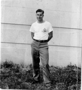
Gerald F. Sanders outside house
https://search.heritageburnaby.ca/link/museumdescription9901
- Repository
- Burnaby Village Museum
- Date
- 1942
- Collection/Fonds
- Gerald F. Sanders and Alice Sparman Sanders fonds
- Description Level
- Item
- Physical Description
- 1 photograph : b&w ; 4.5 x 4 cm
- Scope and Content
- Gerald F. Sanders stands on grass at the back of the family's house on Spruce Street. He wears pants and a t-shirt with RCAF insignia.
- Repository
- Burnaby Village Museum
- Collection/Fonds
- Gerald F. Sanders and Alice Sparman Sanders fonds
- Description Level
- Item
- Physical Description
- 1 photograph : b&w ; 4.5 x 4 cm
- Material Details
- Text in blue ink on verso "GFSANDERS. / 1942 AIRFORCE / ST THOMAS. / ONTARIO."
- Scope and Content
- Gerald F. Sanders stands on grass at the back of the family's house on Spruce Street. He wears pants and a t-shirt with RCAF insignia.
- Subjects
- Wars - World War, 1939-1945
- Names
- Sanders, Gerald Frank
- Geographic Access
- Spruce Street
- Street Address
- 4092 Spruce Street
- Accession Code
- BV018.34.26
- Access Restriction
- No restrictions
- Reproduction Restriction
- No known restrictions
- Date
- 1942
- Media Type
- Photograph
- Historic Neighbourhood
- Broadview (Historic Neighbourhood)
- Planning Study Area
- Cascade-Schou Area
- Scan Resolution
- 600
- Scan Date
- 2022-07-12
- Notes
- Title based on contents of photograph
Images

![Sanders family, [1942] thumbnail](/media/hpo/_Data/_BVM_Images/2018/2018_0034_0027_001.jpg?width=280)
Sanders family
https://search.heritageburnaby.ca/link/museumdescription9902
- Repository
- Burnaby Village Museum
- Date
- [1942]
- Collection/Fonds
- Gerald F. Sanders and Alice Sparman Sanders fonds
- Description Level
- Item
- Physical Description
- 1 photograph : b&w ; 5.5 x 8 cm
- Scope and Content
- Three generations of Sanders family outside with tree in background. Front row seated from left to right: Gerald F. Sanders, Dennis Sanders, Eileen Sanders, Reginald Sanders. Back row standing from left to right: Frank Sanders, unknown woman and Harriett Sanders.
- Repository
- Burnaby Village Museum
- Collection/Fonds
- Gerald F. Sanders and Alice Sparman Sanders fonds
- Description Level
- Item
- Physical Description
- 1 photograph : b&w ; 5.5 x 8 cm
- Scope and Content
- Three generations of Sanders family outside with tree in background. Front row seated from left to right: Gerald F. Sanders, Dennis Sanders, Eileen Sanders, Reginald Sanders. Back row standing from left to right: Frank Sanders, unknown woman and Harriett Sanders.
- Names
- Sanders, Gerald Frank
- Sanders, Eileen
- Sanders, Dennis
- Sanders, Reginald
- Sanders, Frank
- Sanders, Harriett Agnes Chalkley
- Accession Code
- BV018.34.27
- Access Restriction
- No restrictions
- Reproduction Restriction
- No known restrictions
- Date
- [1942]
- Media Type
- Photograph
- Historic Neighbourhood
- Broadview (Historic Neighbourhood)
- Planning Study Area
- Cascade-Schou Area
- Scan Resolution
- 600
- Scan Date
- 2022-07-12
- Notes
- Title based on contents of photograph
Images
![Sanders family, [1942] thumbnail](/media/hpo/_Data/_BVM_Images/2018/2018_0034_0027_001.jpg)
![Subdivision plans in New Westminster District Group 1 – Burnaby
, [1890-1910] thumbnail](/media/hpo/_Data/_BVM_Cartographic_Material/1977/1977_0093_0014a_001.jpg?width=280)
Subdivision plans in New Westminster District Group 1 – Burnaby
https://search.heritageburnaby.ca/link/museumdescription6983
- Repository
- Burnaby Village Museum
- Date
- [1890-1910]
- Collection/Fonds
- Burnaby Village Museum Map collection
- Description Level
- File
- Physical Description
- 4 plans : blueprint ink on paper mounted on 2 sides of cardboard 76 x 102 cm
- Scope and Content
- Item consists of a large board of two New Westminster District Gp 1 - subdivision plans mounted on one side and two New Westminster District Gp 1 - subdivision plans mounted on the other side. Side A: 1. Blueprint "Plan of / Subdivision of Lot No. 69 / Group One / New Westminster District / Pro…
- Repository
- Burnaby Village Museum
- Collection/Fonds
- Burnaby Village Museum Map collection
- Description Level
- File
- Physical Description
- 4 plans : blueprint ink on paper mounted on 2 sides of cardboard 76 x 102 cm
- Material Details
- Scales [between 1:1584 and 1:3168]
- Index number on edge of board reads: "14"
- Scope and Content
- Item consists of a large board of two New Westminster District Gp 1 - subdivision plans mounted on one side and two New Westminster District Gp 1 - subdivision plans mounted on the other side. Side A: 1. Blueprint "Plan of / Subdivision of Lot No. 69 / Group One / New Westminster District / Property of Ernest Buse, Esq. / Scale 3 chs = 1 in. / Map No 290". Plan is signed by "Garden, Hermon and Burwell, Dom. Land Surveyor" (Geographic location: Burnaby) 2. Blueprint "Plan / of Subdivision / of Lots 1-19, 36-53 and 69-75 inclusive / in the Subdivision / of / Lot 30 / Group One / New Westminster District / Scale 2 chs = 1 in. Map No 631". Plan is signed by "Jno [sic] Strathern [sic] P.L.S." Names and Lot numbers are handwritten in red pencil in sections along Douglas Road and read: "20 - F / 21 - Fitherstruhaul [sic] / 22 - J.S. Craig / 23 - McGill & Dill / 24 / 25 / 26 / 27 / 28 - School / 29 - School / 30 - D. McDownall / 31 - W.J. Troloow [sic] / 32 - N.C. Nelson / 33 - _[sic] McGill / 34 - T.S.[sic] Craig / 35" (Geographic location: Burnaby) Side B: 1.Blueprint "Plan / of Subdivision / of Centre Portion / of Lot 28 / Group One / New Westminster District / Scale 200' = 1" / Map No 627". Plan is signed by "Jno Strathern / P.L.S." (Geographic location: Burnaby) 2. Blueprint "Plan / of Subdivision / of N.1/2 Lot 100 and S.1/2 Lot 101, / Group One / New Westminster District, BC / Scale 4 chs = 1 in." (Geographic location: Burnaby)
- Names
- Strathern, John
- Accession Code
- HV977.93.14
- Access Restriction
- No restrictions
- Reproduction Restriction
- No known restrictions
- Date
- [1890-1910]
- Media Type
- Cartographic Material
- Historic Neighbourhood
- Broadview (Historic Neighbourhood)
- East Burnaby (Historic Neighbourhood)
- Planning Study Area
- Cascade-Schou Area
- West Central Valley Area
- Second Street Area
- Lake City Area
- Scan Resolution
- 300
- Scale
- 72
- Notes
- Title based on contents of file
- Scale is measured in chains and feet. (One chain equals 792 inches)
- The term "Lot" can also refer to a "District Lot”
Images
![Subdivision plans in New Westminster District Group 1 – Burnaby
, [1890-1910] thumbnail](/media/hpo/_Data/_BVM_Cartographic_Material/1977/1977_0093_0014a_001.jpg)
