Narrow Results By
Subject
- Agriculture - Farms 1
- Agriculture - Orchards 1
- Animals - Poultry 1
- Buildings - Commercial - Train Stations 1
- Buildings - Heritage 108
- Buildings - Residential - Houses 22
- Buildings - Schools 1
- Businesses - Real Estate Agencies 1
- Clothing - Uniforms 1
- Furniture 1
- Geographic Features - Roads 3
- Musical Instruments - Pianos 2
Creator
- British Columbia Underwriters' Association 1
- Burnett, Geoffrey K. 3
- Burnett & McGugan, Engineers and Surveyors 1
- Jones, Charles Spurgeon "Chuck" 1
- Leibly & Blumer Realty Co. Incorporated 1
- Parker, Albert "Bert" 26
- Plan Department, British Columbia Insurance Underwriters' Association 1
- Stevens, Colin 17
- Stride, Charles Edgar 1
- Wolf, Jim 44
Person / Organization
- A & H Plastering and Stucco 1
- Armstrong Avenue School 2
- Barnes, Hannah Victoria "Girlie" Love 3
- Beaton, N. 1
- Bolton, Richard 1
- Bowes, M. 1
- Brandrith, Benjamin Jefferson "Ben" 1
- Brandrith, Martha Dorothy “Dot” Love 2
- Brown, Charles B. "Charlie" 1
- Brown, Clifton Gilbert, 1889-1960 1
- Burnaby Village Museum 1
- Burnett, Geoffrey K. 2

building
https://search.heritageburnaby.ca/link/museumartifact3846
- Repository
- Burnaby Village Museum
- Accession Code
- BV988.33.1
- Description
- The core of the Jessie Love farm house is a 1893 two story, pioneer tent style building. The home was added to over the years and became a large Craftsmen style farm house.
- Object History
- Built on Cumberland Road in Burnaby in 1893. Music Room/Parlour/Living Room and bedrooms above added c.1898. Kitchen added c.1908. The home of Jesse and Martha Love and their eleven children. One of Burnaby's oldest structures. The home was moved to Burnaby Village Museum in the late 1980s and has been partially restored to its 1920s appearance.
- Category
- 01. Built Environment Objects
- Classification
- Structures - - Dwellings
- Object Term
- House
- Colour
- Brown
- Culture
- Canadian
- Geographic Access
- Cumberland Street
- Street Address
- 6501 Deer Lake Avenue
- Historic Neighbourhood
- East Burnaby (Historic Neighbourhood)
- Planning Study Area
- Cariboo-Armstrong Area
Images


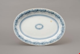
platter
https://search.heritageburnaby.ca/link/museumartifact83513
- Repository
- Burnaby Village Museum
- Accession Code
- BV013.22.1
- Description
- Serving platter, 16 X 12 inches. Made by J & G Meakin, Hanley, England. It is a [C]haplet patern. Blue patern with raised dots around the top edge. The patern is raised on the short sides of the oval. There is a chip on the inside of the bottom surface. "21 is pressed into the underside.
- Object History
- This platter was handed down from Martha Love through three generations to the donor.
- Reference
- http://en.wikipedia.org/wiki/J._%26_G._Meakin - short history of J & G Meakin.
- Maker
- J. & G. Meakin Limited
- Country Made
- England
- Site/City Made
- Hanley
- Historic Neighbourhood
- East Burnaby (Historic Neighbourhood)
- Planning Study Area
- Cariboo-Armstrong Area
Images
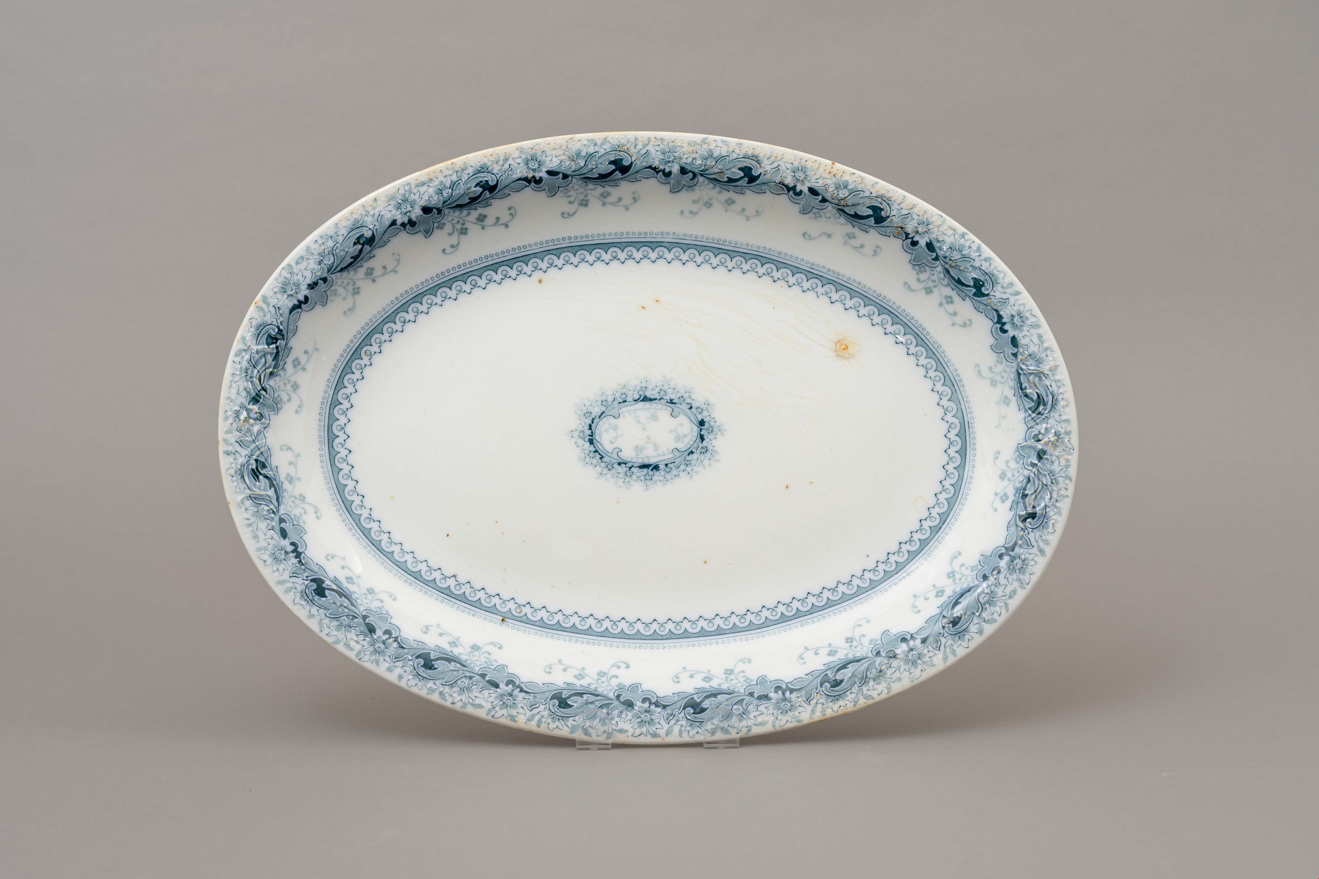
dining chair
https://search.heritageburnaby.ca/link/museumartifact90002
- Repository
- Burnaby Village Museum
- Accession Code
- BV019.8.15
- Description
- dining chair; side chair; brown painted wood; chair back has four vertical spindles; two horizontal stretchers between front and side legs; one horizontal stretcher between back legs.
- Object History
- Object used in the dining room of the Love farmhouse. The layers of paint beneath the brown outer layer reveal past colours of the chair that are documented in BVM photographs of the interior of the Love farmhouse.
- Category
- 02. Furnishings
- Classification
- Furniture - - Seating Furniture
- Object Term
- Chair
- Subjects
- Furniture
- Geographic Access
- Cumberland Street
- Street Address
- 7651 Cumberland Street
- Historic Neighbourhood
- East Burnaby (Historic Neighbourhood)
- Planning Study Area
- Cariboo-Armstrong Area
Images

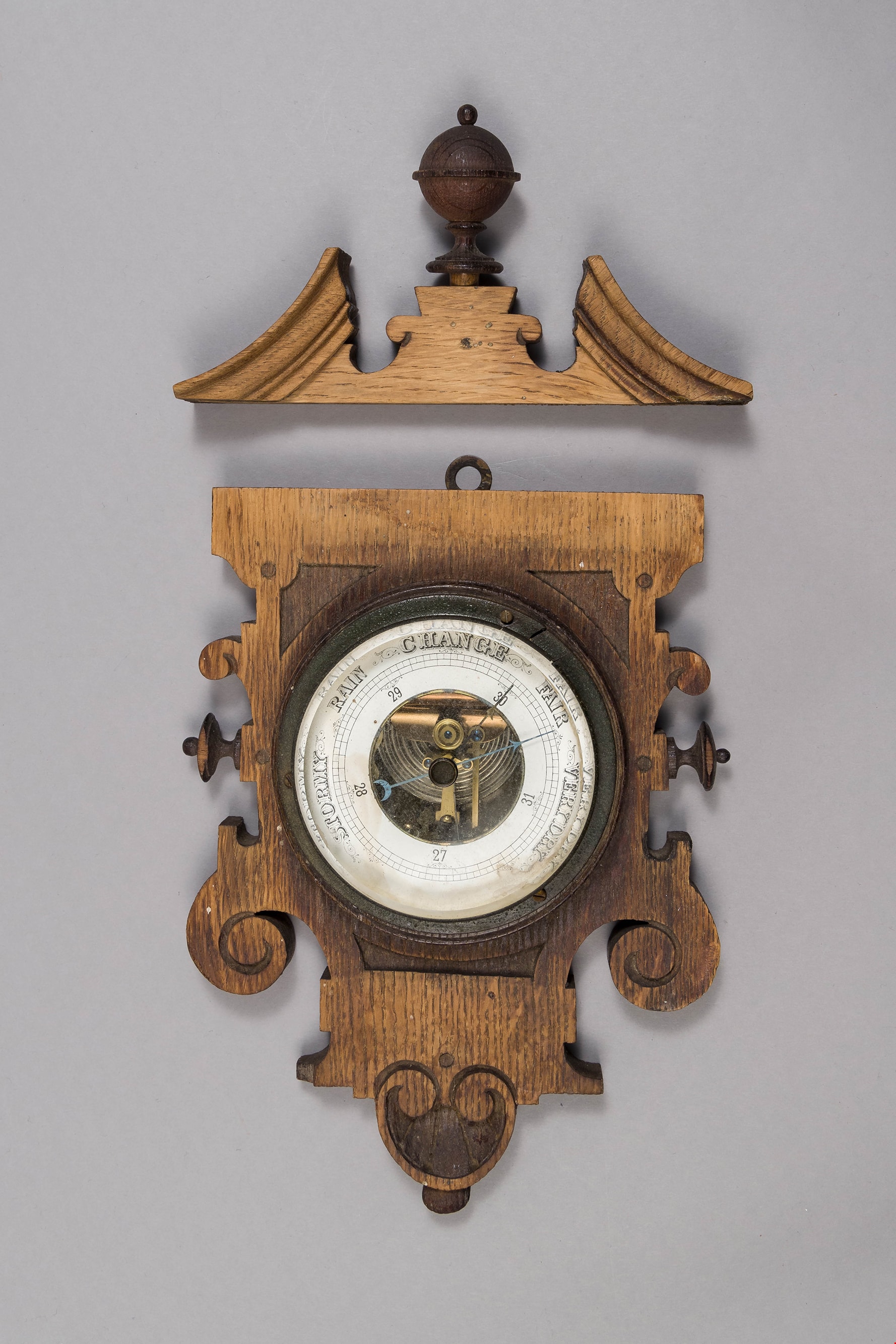
barometer
https://search.heritageburnaby.ca/link/museumartifact90178
- Repository
- Burnaby Village Museum
- Accession Code
- BV019.8.16
- Description
- barometer; aneroid barometer secured to a carved wood plaque; barometer has a calibrated dial to indicate air pressure; text on dial reads: "VERY DRY", "FAIR", "CHANGE", "RAIN", and "STORMY"; flat metal loop at top of wood plaque for hanging. Dark stained carved wood decorative scroll with finial; has detached from base plaque.
- Object History
- Object used in the Love Farmhouse, currently on site at Burnaby Village Museum.
- Geographic Access
- Cumberland Street
- Street Address
- 7651 Cumberland Street
- Historic Neighbourhood
- East Burnaby (Historic Neighbourhood)
- Planning Study Area
- Cariboo-Armstrong Area
Images

Love House going south on Cumberland Street
https://search.heritageburnaby.ca/link/museumdescription10906
- Repository
- Burnaby Village Museum
- Collection/Fonds
- Burnaby Village Museum fonds
- Description Level
- Item
- Physical Description
- 1 photograph : col. negative ; 35 mm
- Scope and Content
- Photograph of the Love farmhouse moving south on Cumberland Street by little park where kitchen had been placed temporarily. The house is being moved from it's original site at 7651 Cumberland Street to the site of the Burnaby Village Museum.
- Repository
- Burnaby Village Museum
- Collection/Fonds
- Burnaby Village Museum fonds
- Series
- Jesse Love farmhouse series
- Description Level
- Item
- Physical Description
- 1 photograph : col. negative ; 35 mm
- Material Details
- Photograph is part of Film roll "3829" - 20 colour negatives and 18 colour photographs that are a part of a collection described as BV018.41.82
- Scope and Content
- Photograph of the Love farmhouse moving south on Cumberland Street by little park where kitchen had been placed temporarily. The house is being moved from it's original site at 7651 Cumberland Street to the site of the Burnaby Village Museum.
- Subjects
- Buildings - Heritage
- Geographic Access
- Cumberland Street
- Street Address
- 7651 Cumberland Street
- Accession Code
- BV018.41.428
- Access Restriction
- No restrictions
- Reproduction Restriction
- No known restrictions
- Media Type
- Photograph
- Historic Neighbourhood
- East Burnaby (Historic Neighbourhood)
- Planning Study Area
- Cariboo-Armstrong Area
- Related Material
- See BV018.41.82 for File Level Description
- Scan Resolution
- 2400
- Scan Date
- 27-Aug-2019
- Scale
- 100
- Photographer
- Stevens, Colin
- Notes
- Title based on contents of photograph
- Photograph is a part of file level description "Photographic documentation of changes and move" BV018.41.82
Images
![Jesse Love farmhouse, [between 1893 and 1897] (date of original), copied 1998 thumbnail](/media/hpo/_Data/_BVM_Images/2000/200000450002.jpg?width=280)
Jesse Love farmhouse
https://search.heritageburnaby.ca/link/museumdescription1551
- Repository
- Burnaby Village Museum
- Date
- [between 1893 and 1897] (date of original), copied 1998
- Collection/Fonds
- Love family fonds
- Description Level
- Item
- Physical Description
- 1 photograph : b&w ; 19 x 25 cm print
- Scope and Content
- Photograph of the Jesse Love farmhouse. The Love farmhouse was located at 1390 Cumberland Road (after 1960- address was changed to 7651 Cumberland Street). The Love farmhouse was relocated to the site of the Burnaby Village Museum in 1988 where it was restored to the 1920s era.
- Repository
- Burnaby Village Museum
- Collection/Fonds
- Love family fonds
- Description Level
- Item
- Physical Description
- 1 photograph : b&w ; 19 x 25 cm print
- Scope and Content
- Photograph of the Jesse Love farmhouse. The Love farmhouse was located at 1390 Cumberland Road (after 1960- address was changed to 7651 Cumberland Street). The Love farmhouse was relocated to the site of the Burnaby Village Museum in 1988 where it was restored to the 1920s era.
- Subjects
- Buildings - Residential - Houses
- Geographic Access
- Cumberland Street
- Street Address
- 7651 Cumberland Street
- Accession Code
- BV000.45.2
- Access Restriction
- No restrictions
- Date
- [between 1893 and 1897] (date of original), copied 1998
- Media Type
- Photograph
- Historic Neighbourhood
- East Burnaby (Historic Neighbourhood)
- Planning Study Area
- Cariboo-Armstrong Area
- Scan Resolution
- 600
- Scan Date
- 09-Jun-09
- Scale
- 100
- Notes
- Title based on note on verso of photograph
- Note in pencil on verso of photograph reads: "Jesse Love Farmhouse"
Images
![Jesse Love farmhouse, [between 1893 and 1897] (date of original), copied 1998 thumbnail](/media/hpo/_Data/_BVM_Images/2000/200000450002.jpg)
![Jesse and Martha Love farmhouse, [between 1893 and 1905] (date of original), copied [1988] thumbnail](/media/hpo/_Data/_BVM_Images/1985/1985_3136_0001_001.jpg?width=280)
Jesse and Martha Love farmhouse
https://search.heritageburnaby.ca/link/museumdescription2999
- Repository
- Burnaby Village Museum
- Date
- [between 1893 and 1905] (date of original), copied [1988]
- Collection/Fonds
- Love family fonds
- Description Level
- Item
- Physical Description
- 1 photograph : b&w print ; 9 x 13 cm print
- Scope and Content
- Photograph of the south side of Love Farmhouse prior to the addition of the kitchen. The Love farmhouse was built in 1893 by Jesse Love and was located at 1390 Cumberland Road at the corner of 14th Avenue (after 1960- address was changed to 7651 Cumberland Street). The Love farmhouse was relocated …
- Repository
- Burnaby Village Museum
- Collection/Fonds
- Love family fonds
- Description Level
- Item
- Physical Description
- 1 photograph : b&w print ; 9 x 13 cm print
- Scope and Content
- Photograph of the south side of Love Farmhouse prior to the addition of the kitchen. The Love farmhouse was built in 1893 by Jesse Love and was located at 1390 Cumberland Road at the corner of 14th Avenue (after 1960- address was changed to 7651 Cumberland Street). The Love farmhouse was relocated to the site of the Burnaby Village Museum in 1988 where it was restored to the 1920s era.
- Subjects
- Buildings - Heritage
- Geographic Access
- Cumberland Street
- Street Address
- 7651 Cumberland Street
- Accession Code
- BV985.3136.1
- Access Restriction
- No restrictions
- Reproduction Restriction
- No known restrictions
- Date
- [between 1893 and 1905] (date of original), copied [1988]
- Media Type
- Photograph
- Historic Neighbourhood
- East Burnaby (Historic Neighbourhood)
- Planning Study Area
- Cariboo-Armstrong Area
- Scan Resolution
- 600
- Scan Date
- 16-Jan-24
- Notes
- Title based on content of photograph
- Label on front of photograph reads: "Old home side"
- Label beneath photograph in original album reads:" Old home field"
- 1 b&w copy negative accompanying
Images
![Jesse and Martha Love farmhouse, [between 1893 and 1905] (date of original), copied [1988] thumbnail](/media/hpo/_Data/_BVM_Images/1985/1985_3136_0001_001.jpg)
![Jesse Love farmhouse, [between 1900 and 1905] (date of original), copied 1998 thumbnail](/media/hpo/_Data/_BVM_Images/2000/200000450001.jpg?width=280)
Jesse Love farmhouse
https://search.heritageburnaby.ca/link/museumdescription1550
- Repository
- Burnaby Village Museum
- Date
- [between 1900 and 1905] (date of original), copied 1998
- Collection/Fonds
- Love family fonds
- Description Level
- Item
- Physical Description
- 1 photograph : b&w ; 18 x 25 cm print
- Scope and Content
- Photograph of two women standing by the wooden picket fence that surrounds the Jesse Love Farmhouse (very high pickets have been used for part of the fence).The Love farmhouse was located at 1390 Cumberland Road (after 1960- address was changed to 7651 Cumberland Street). The Love farmhouse was rel…
- Repository
- Burnaby Village Museum
- Collection/Fonds
- Love family fonds
- Description Level
- Item
- Physical Description
- 1 photograph : b&w ; 18 x 25 cm print
- Scope and Content
- Photograph of two women standing by the wooden picket fence that surrounds the Jesse Love Farmhouse (very high pickets have been used for part of the fence).The Love farmhouse was located at 1390 Cumberland Road (after 1960- address was changed to 7651 Cumberland Street). The Love farmhouse was relocated to the site of the Burnaby Village Museum in 1988 where it was restored to the 1920s era.
- Subjects
- Buildings - Heritage
- Structures - Fences
- Geographic Access
- Cumberland Street
- Street Address
- 7651 Cumberland Street
- Accession Code
- BV000.45.1
- Access Restriction
- No restrictions
- Date
- [between 1900 and 1905] (date of original), copied 1998
- Media Type
- Photograph
- Historic Neighbourhood
- East Burnaby (Historic Neighbourhood)
- Planning Study Area
- Cariboo-Armstrong Area
- Scan Resolution
- 600
- Scan Date
- 09-Jun-09
- Scale
- 100
- Notes
- Title based on contents of photograph
- Note in pencil on verso of photograph reads: "Jesse Love Farmhouse Burnaby BC"
- See also photograph: BV018.41.146
Images
![Jesse Love farmhouse, [between 1900 and 1905] (date of original), copied 1998 thumbnail](/media/hpo/_Data/_BVM_Images/2000/200000450001.jpg)
![Jesse Love farmhouse, [between 1900 and 1905] (date of original), copied [1988] thumbnail](/media/hpo/_Data/_BVM_Images/2018/2018_0041_0199_001.jpg?width=280)
Jesse Love farmhouse
https://search.heritageburnaby.ca/link/museumdescription9958
- Repository
- Burnaby Village Museum
- Date
- [between 1900 and 1905] (date of original), copied [1988]
- Collection/Fonds
- Burnaby Village Museum fonds
- Description Level
- Item
- Physical Description
- 1 photograph : col. slide ; 35 mm
- Scope and Content
- Photograph of two women standing by the wooden picket fence that surrounds the Jesse Love farmhouse (very high pickets have been used for part of the fence).The Love farmhouse was located at 1390 Cumberland Road (after 1960- address was changed to 7651 Cumberland Street). The Love farmhouse was rel…
- Repository
- Burnaby Village Museum
- Collection/Fonds
- Burnaby Village Museum fonds
- Series
- Jesse Love farmhouse series
- Subseries
- Love family photographs subseries
- Description Level
- Item
- Physical Description
- 1 photograph : col. slide ; 35 mm
- Scope and Content
- Photograph of two women standing by the wooden picket fence that surrounds the Jesse Love farmhouse (very high pickets have been used for part of the fence).The Love farmhouse was located at 1390 Cumberland Road (after 1960- address was changed to 7651 Cumberland Street). The Love farmhouse was relocated to the site of the Burnaby Village Museum in 1988 where it was restored to the 1920s era.
- Geographic Access
- Cumberland Street
- Street Address
- 7651 Cumberland Street
- Accession Code
- BV018.41.199
- Access Restriction
- No restrictions
- Reproduction Restriction
- May be restricted by third party rights
- Date
- [between 1900 and 1905] (date of original), copied [1988]
- Media Type
- Photograph
- Historic Neighbourhood
- East Burnaby (Historic Neighbourhood)
- Planning Study Area
- Cariboo-Armstrong Area
- Scan Resolution
- 2400
- Scan Date
- 4-Mar-2019
- Scale
- 100
- Notes
- Title based on content of photograph
Images
![Jesse Love farmhouse, [between 1900 and 1905] (date of original), copied [1988] thumbnail](/media/hpo/_Data/_BVM_Images/2018/2018_0041_0199_001.jpg)
![Four generations, [between 1900 and 1909] (date of original), copied [1988] thumbnail](/media/hpo/_Data/_BVM_Images/2018/2018_0041_0200_001.jpg?width=280)
Four generations
https://search.heritageburnaby.ca/link/museumdescription9959
- Repository
- Burnaby Village Museum
- Date
- [between 1900 and 1909] (date of original), copied [1988]
- Collection/Fonds
- Burnaby Village Museum fonds
- Description Level
- Item
- Physical Description
- 1 photograph : col. slide ; 35 mm
- Scope and Content
- Photograph of (left to right) Annn (Annie) Elizabeth Whiting (nee Love), her mother, Mrs. Martha Love and her grandfather George Leonard and her daughter Edith Whiting.The group is gathered together outside in a yard with a fence of what might be the home of Jesse and Martha Love.
- Repository
- Burnaby Village Museum
- Collection/Fonds
- Burnaby Village Museum fonds
- Series
- Jesse Love farmhouse series
- Subseries
- Love family photographs subseries
- Description Level
- Item
- Physical Description
- 1 photograph : col. slide ; 35 mm
- Scope and Content
- Photograph of (left to right) Annn (Annie) Elizabeth Whiting (nee Love), her mother, Mrs. Martha Love and her grandfather George Leonard and her daughter Edith Whiting.The group is gathered together outside in a yard with a fence of what might be the home of Jesse and Martha Love.
- Subjects
- Structures - Fences
- Names
- Leonard, George
- Love Family
- Whiting, Annie Elizabeth Love
- Clayton, Edith Annie Whiting
- Stanley, Esther Love
- Love, Martha Leonard, 1858-1920
- Geographic Access
- Cumberland Street
- Street Address
- 7651 Cumberland Street
- Accession Code
- BV018.41.200
- Access Restriction
- No restrictions
- Reproduction Restriction
- May be restricted by third party rights
- Date
- [between 1900 and 1909] (date of original), copied [1988]
- Media Type
- Photograph
- Historic Neighbourhood
- East Burnaby (Historic Neighbourhood)
- Planning Study Area
- Cariboo-Armstrong Area
- Scan Resolution
- 2400
- Scan Date
- 4-Mar-2019
- Scale
- 100
- Notes
- Title based on contents of photograph
Images
![Four generations, [between 1900 and 1909] (date of original), copied [1988] thumbnail](/media/hpo/_Data/_BVM_Images/2018/2018_0041_0200_001.jpg)
![Love farmhouse in winter, [1900] (date of original), copied [1988] thumbnail](/media/hpo/_Data/_BVM_Images/2018/2018_0041_0202_001.jpg?width=280)
Love farmhouse in winter
https://search.heritageburnaby.ca/link/museumdescription9960
- Repository
- Burnaby Village Museum
- Date
- [1900] (date of original), copied [1988]
- Collection/Fonds
- Burnaby Village Museum fonds
- Description Level
- Item
- Physical Description
- 1 photograph : col. slide ; 35 mm
- Scope and Content
- Photograph of the Love family farmhouse located at 1390 Cumberland Road (later renumbered 7651 Cumberland Street), East Burnaby. A mature conifer tree sits next to the house, both are covered in snow. The house was built by Jesse Love with the help of George Salt in 1893. In 1988, this house was mo…
- Repository
- Burnaby Village Museum
- Collection/Fonds
- Burnaby Village Museum fonds
- Series
- Jesse Love farmhouse series
- Subseries
- Love family photographs subseries
- Description Level
- Item
- Physical Description
- 1 photograph : col. slide ; 35 mm
- Scope and Content
- Photograph of the Love family farmhouse located at 1390 Cumberland Road (later renumbered 7651 Cumberland Street), East Burnaby. A mature conifer tree sits next to the house, both are covered in snow. The house was built by Jesse Love with the help of George Salt in 1893. In 1988, this house was moved to the site of the Burnaby Village Museum at 6501 Deer Lake Avenue where it was restored to the 1920s era.
- Geographic Access
- Cumberland Street
- Street Address
- 7651 Cumberland Street
- Accession Code
- BV018.41.202
- Access Restriction
- No restrictions
- Reproduction Restriction
- May be restricted by third party rights
- Date
- [1900] (date of original), copied [1988]
- Media Type
- Photograph
- Historic Neighbourhood
- East Burnaby (Historic Neighbourhood)
- Planning Study Area
- Cariboo-Armstrong Area
- Scan Resolution
- 2400
- Scan Date
- 4-Mar-2019
- Scale
- 100
- Notes
- Title based on contents of photograph
- Annotation on bottom of photograph reads: "1390 Cumberland Rd, the old home"
Images
![Love farmhouse in winter, [1900] (date of original), copied [1988] thumbnail](/media/hpo/_Data/_BVM_Images/2018/2018_0041_0202_001.jpg)
Copies of Esther (Love) Stanley photograph album pages
https://search.heritageburnaby.ca/link/museumdescription10015
- Repository
- Burnaby Village Museum
- Date
- [1900-1930] (date of originals), copied 1988
- Collection/Fonds
- Burnaby Village Museum fonds
- Description Level
- File
- Physical Description
- 25 photographs : b&w negatives ; 35 mm
- Scope and Content
- Photographs of pages from a photograph album belonging to Esther (Love) Stanley. Each photograph includes five to nine images per page as per the arrangement of the original album.
- Repository
- Burnaby Village Museum
- Collection/Fonds
- Burnaby Village Museum fonds
- Series
- Jesse Love farmhouse series
- Subseries
- Love family photographs subseries
- Description Level
- File
- Physical Description
- 25 photographs : b&w negatives ; 35 mm
- Scope and Content
- Photographs of pages from a photograph album belonging to Esther (Love) Stanley. Each photograph includes five to nine images per page as per the arrangement of the original album.
- Subjects
- Buildings - Heritage
- Geographic Access
- Cumberland Street
- Street Address
- 7651 Cumberland Street
- Accession Code
- BV018.41.194
- Access Restriction
- No restrictions
- Reproduction Restriction
- May be restricted by third party rights
- Date
- [1900-1930] (date of originals), copied 1988
- Media Type
- Photograph
- Historic Neighbourhood
- East Burnaby (Historic Neighbourhood)
- Planning Study Area
- Cariboo-Armstrong Area
- Notes
- Title based on contents of photograph
- 21 b&w copy prints accompanying
Copies of Esther (Love) Stanley photograph album pages
https://search.heritageburnaby.ca/link/museumdescription10016
- Repository
- Burnaby Village Museum
- Date
- [1900-1930] (date of originals), copied 1989
- Collection/Fonds
- Burnaby Village Museum fonds
- Description Level
- File
- Physical Description
- 37 photographs : b&w negatives ; 35 mm
- Scope and Content
- Photographs of pages from a photograph album belonging to Esther (Love) Stanley. Each photograph includes one to four images per page as per the arrangement of the original album.
- Repository
- Burnaby Village Museum
- Collection/Fonds
- Burnaby Village Museum fonds
- Series
- Jesse Love farmhouse series
- Subseries
- Love family photographs subseries
- Description Level
- File
- Physical Description
- 37 photographs : b&w negatives ; 35 mm
- Scope and Content
- Photographs of pages from a photograph album belonging to Esther (Love) Stanley. Each photograph includes one to four images per page as per the arrangement of the original album.
- Subjects
- Buildings - Heritage
- Geographic Access
- Cumberland Street
- Street Address
- 7651 Cumberland Street
- Accession Code
- BV018.41.195
- Access Restriction
- No restrictions
- Reproduction Restriction
- May be restricted by third party rights
- Date
- [1900-1930] (date of originals), copied 1989
- Media Type
- Photograph
- Historic Neighbourhood
- East Burnaby (Historic Neighbourhood)
- Planning Study Area
- Cariboo-Armstrong Area
- Notes
- Title based on contents of photograph
- 39 b&w copy prints accompanying (two copy prints are close ups from negatives)
![Love family at their farmhouse, [1910] (date of original), copied 1998 thumbnail](/media/hpo/_Data/_BVM_Images/2000/200000450004.jpg?width=280)
Love family at their farmhouse
https://search.heritageburnaby.ca/link/museumdescription1553
- Repository
- Burnaby Village Museum
- Date
- [1910] (date of original), copied 1998
- Collection/Fonds
- Love family fonds
- Description Level
- Item
- Physical Description
- 1 photograph : b&w ; 25 x 16.5 cm print
- Scope and Content
- Photograph of Jesse and Martha Love with two of their daughters in front of their farmhouse. Martha is wearing an apron and Jesse is holding his neck with his left hand. The Love farmhouse was located at 1390 Cumberland Road (after 1960- address was changed to 7651 Cumberland Street). The Love far…
- Repository
- Burnaby Village Museum
- Collection/Fonds
- Love family fonds
- Description Level
- Item
- Physical Description
- 1 photograph : b&w ; 25 x 16.5 cm print
- Scope and Content
- Photograph of Jesse and Martha Love with two of their daughters in front of their farmhouse. Martha is wearing an apron and Jesse is holding his neck with his left hand. The Love farmhouse was located at 1390 Cumberland Road (after 1960- address was changed to 7651 Cumberland Street). The Love farmhouse was relocated to the site of the Burnaby Village Museum in 1988 where it was restored to the 1920s era.
- Subjects
- Buildings - Residential - Houses
- Geographic Access
- Cumberland Street
- Street Address
- 7651 Cumberland Street
- Accession Code
- BV000.45.4
- Access Restriction
- No restrictions
- Date
- [1910] (date of original), copied 1998
- Media Type
- Photograph
- Historic Neighbourhood
- East Burnaby (Historic Neighbourhood)
- Planning Study Area
- Cariboo-Armstrong Area
- Scan Resolution
- 600
- Scan Date
- 09-Jun-09
- Scale
- 100
- Notes
- Title based on contents of photograph
- 1 b&w copy negative accompanying
- Note in pencil on verso of photograph reads: "Jesse and Martha Love and 2 daughters Jesse Love Farmhouse"
Images
![Love family at their farmhouse, [1910] (date of original), copied 1998 thumbnail](/media/hpo/_Data/_BVM_Images/2000/200000450004.jpg)
Copies of Esther (Love) Stanley photograph album pages
https://search.heritageburnaby.ca/link/museumdescription10013
- Repository
- Burnaby Village Museum
- Date
- [1910-1930] (date of originals), copied 1989
- Collection/Fonds
- Burnaby Village Museum fonds
- Description Level
- File
- Physical Description
- 26 photographs : b&w negatives ; 35 mm
- Scope and Content
- Photographs of pages from a photograph album belonging to Esther (Love) Stanley. Each photograph includes five to seven images per page as per the arrangement of the original album.
- Repository
- Burnaby Village Museum
- Collection/Fonds
- Burnaby Village Museum fonds
- Series
- Jesse Love farmhouse series
- Subseries
- Love family photographs subseries
- Description Level
- File
- Physical Description
- 26 photographs : b&w negatives ; 35 mm
- Scope and Content
- Photographs of pages from a photograph album belonging to Esther (Love) Stanley. Each photograph includes five to seven images per page as per the arrangement of the original album.
- Subjects
- Buildings - Heritage
- Geographic Access
- Cumberland Street
- Street Address
- 7651 Cumberland Street
- Accession Code
- BV018.41.193
- Access Restriction
- No restrictions
- Reproduction Restriction
- May be restricted by third party rights
- Date
- [1910-1930] (date of originals), copied 1989
- Media Type
- Photograph
- Historic Neighbourhood
- East Burnaby (Historic Neighbourhood)
- Planning Study Area
- Cariboo-Armstrong Area
- Notes
- Title based on contents of photograph
- 26 b&w copy prints accompanying
![Jesse Love feeding chickens, [191-] thumbnail](/media/hpo/_Data/_BVM_Images/2022/2022_0032_0102_001.jpg?width=280)
Jesse Love feeding chickens
https://search.heritageburnaby.ca/link/museumdescription19680
- Repository
- Burnaby Village Museum
- Date
- [191-]
- Collection/Fonds
- Esther Love Stanley fonds
- Description Level
- Item
- Physical Description
- 1 photograph : b&w ; 7.5 x 10.5 cm
- Scope and Content
- Photograph of Jesse Love feeding chickens at his home on Cumberland Street. Shadow of photographer is visible on the ground in front.
- Repository
- Burnaby Village Museum
- Collection/Fonds
- Esther Love Stanley fonds
- Description Level
- Item
- Physical Description
- 1 photograph : b&w ; 7.5 x 10.5 cm
- Scope and Content
- Photograph of Jesse Love feeding chickens at his home on Cumberland Street. Shadow of photographer is visible on the ground in front.
- Subjects
- Animals - Poultry
- Names
- Love, Jesse, 1849-1928
- Geographic Access
- Cumberland Street
- Street Address
- 7651 Cumberland Street
- Accession Code
- BV022.32.102
- Access Restriction
- No restrictions
- Reproduction Restriction
- No known restrictions
- Date
- [191-]
- Media Type
- Photograph
- Historic Neighbourhood
- East Burnaby (Historic Neighbourhood)
- Planning Study Area
- Cariboo-Armstrong Area
- Scan Resolution
- 600
- Scan Date
- 2023-04-04
- Notes
- Title based on contents of photograph
- Photograph is part of Esther Love Stanley photograph album 1 (BV022.32.1)
Images
![Jesse Love feeding chickens, [191-] thumbnail](/media/hpo/_Data/_BVM_Images/2022/2022_0032_0102_001.jpg)
![Bob Love, [191-] thumbnail](/media/hpo/_Data/_BVM_Images/2022/2022_0032_0134_001.jpg?width=280)
Bob Love
https://search.heritageburnaby.ca/link/museumdescription19712
- Repository
- Burnaby Village Museum
- Date
- [191-]
- Collection/Fonds
- Esther Love Stanley fonds
- Description Level
- Item
- Physical Description
- 1 photograph : b&w ; 10.5 x 8 cm
- Scope and Content
- Photograph of Thomas Robert "Bob" Love, standing in an orchard at the Love family home at 1390 Cumberland Road. Bob's right arm is bent with his hand on his waist. He is wearing a white collared shirt with tie, dark pants, belt and suspenders. Orchard trees in full leaf are in background. Bob Love…
- Repository
- Burnaby Village Museum
- Collection/Fonds
- Esther Love Stanley fonds
- Description Level
- Item
- Physical Description
- 1 photograph : b&w ; 10.5 x 8 cm
- Scope and Content
- Photograph of Thomas Robert "Bob" Love, standing in an orchard at the Love family home at 1390 Cumberland Road. Bob's right arm is bent with his hand on his waist. He is wearing a white collared shirt with tie, dark pants, belt and suspenders. Orchard trees in full leaf are in background. Bob Love served in World War 1 and died at the age of 31 years on November 23, 1918.
- Geographic Access
- Cumberland Street
- Street Address
- 7651 Cumberland Street
- Accession Code
- BV022.32.134
- Access Restriction
- No restrictions
- Reproduction Restriction
- No known restrictions
- Date
- [191-]
- Media Type
- Photograph
- Historic Neighbourhood
- East Burnaby (Historic Neighbourhood)
- Planning Study Area
- Cariboo-Armstrong Area
- Scan Resolution
- 600
- Scan Date
- 2023-04-04
- Notes
- Title based on contents of photograph
- Photograph is part of Esther Love Stanley photograph album 1 (BV022.32.1)
Images
![Bob Love, [191-] thumbnail](/media/hpo/_Data/_BVM_Images/2022/2022_0032_0134_001.jpg)
![Jesse and Martha Love, [191-] thumbnail](/media/hpo/_Data/_BVM_Images/2022/2022_0032_0199_001.jpg?width=280)
Jesse and Martha Love
https://search.heritageburnaby.ca/link/museumdescription19777
- Repository
- Burnaby Village Museum
- Date
- [191-]
- Collection/Fonds
- Esther Love Stanley fonds
- Description Level
- Item
- Physical Description
- 1 photograph : b&w ; 11 x 8.5 cm
- Scope and Content
- Photograph of Jesse and Martha Love standing outside their farmhouse located at 1390 Cumberland Road (later renumbered 7651 Cumberland Street). The couple are standing on the lawn with a fence and the farmhouse behind them. Martha is wearing a long dark coloured dress and Jesse has a large beard an…
- Repository
- Burnaby Village Museum
- Collection/Fonds
- Esther Love Stanley fonds
- Description Level
- Item
- Physical Description
- 1 photograph : b&w ; 11 x 8.5 cm
- Scope and Content
- Photograph of Jesse and Martha Love standing outside their farmhouse located at 1390 Cumberland Road (later renumbered 7651 Cumberland Street). The couple are standing on the lawn with a fence and the farmhouse behind them. Martha is wearing a long dark coloured dress and Jesse has a large beard and is wearing a dark coloured suit and tie.
- Geographic Access
- Cumberland Street
- Street Address
- 7651 Cumberland Street
- Accession Code
- BV022.32.199
- Access Restriction
- No restrictions
- Reproduction Restriction
- No known restrictions
- Date
- [191-]
- Media Type
- Photograph
- Historic Neighbourhood
- East Burnaby (Historic Neighbourhood)
- Planning Study Area
- Cariboo-Armstrong Area
- Related Material
- See also City of Burnaby Archives copy print 204-582
- Scan Resolution
- 600
- Scan Date
- 2023-04-04
- Notes
- Title based on contents of photograph
- Photograph is part of Esther Love Stanley photograph album 1 (BV022.32.1)
- Annotation in white ink on album page reads: "Jesse, Martha Love"
Images
![Jesse and Martha Love, [191-] thumbnail](/media/hpo/_Data/_BVM_Images/2022/2022_0032_0199_001.jpg)
![Group in front of Love farmhouse, [191-] thumbnail](/media/hpo/_Data/_BVM_Images/2022/2022_0032_0206_001.jpg?width=280)
Group in front of Love farmhouse
https://search.heritageburnaby.ca/link/museumdescription19784
- Repository
- Burnaby Village Museum
- Date
- [191-]
- Collection/Fonds
- Esther Love Stanley fonds
- Description Level
- Item
- Physical Description
- 1 photograph : b&w ; 8.5 x 11 cm
- Scope and Content
- Photograph of members of the Love, Brandrith and Stanley families in front of the Love farmhouse. The group is identified (standing left to right) as; Leonard Love, Martha Dorothy "Dot" Love, Esther Love, Carrie (friend) and Hannah "Girlie" Love. Ben Brandrith is seated in front (smoking a pie and …
- Repository
- Burnaby Village Museum
- Collection/Fonds
- Esther Love Stanley fonds
- Description Level
- Item
- Physical Description
- 1 photograph : b&w ; 8.5 x 11 cm
- Scope and Content
- Photograph of members of the Love, Brandrith and Stanley families in front of the Love farmhouse. The group is identified (standing left to right) as; Leonard Love, Martha Dorothy "Dot" Love, Esther Love, Carrie (friend) and Hannah "Girlie" Love. Ben Brandrith is seated in front (smoking a pie and dressed in a woman's apron and hat) next to George Love. The man standing on the porch behind the group may be Frank Charles "Stan" Stanley who married Esther Love.
- Names
- Brandrith, Benjamin Jefferson "Ben"
- Barnes, Hannah Victoria "Girlie" Love
- Stanley, Esther Love
- Brandrith, Martha Dorothy “Dot” Love
- Stanley, Frank Charles
- Love, George Richard
- Love Family
- Geographic Access
- Cumberland Street
- Street Address
- 7651 Cumberland Street
- Accession Code
- BV022.32.206
- Access Restriction
- No restrictions
- Reproduction Restriction
- No known restrictions
- Date
- [191-]
- Media Type
- Photograph
- Historic Neighbourhood
- East Burnaby (Historic Neighbourhood)
- Planning Study Area
- Cariboo-Armstrong Area
- Related Material
- See also BV022.32.44 for similar photo
- Scan Resolution
- 600
- Scan Date
- 2023-04-18
- Notes
- Title based on contents of photograph
- Photograph is part of Esther Love Stanley photograph album 1 (BV022.32.1)
- Annotation on album page below photograph reads: "Leonard, Dot, Esther, Carrie, Girlie / Ben, Stan"
Images
![Group in front of Love farmhouse, [191-] thumbnail](/media/hpo/_Data/_BVM_Images/2022/2022_0032_0206_001.jpg)
![Bird's eye view of New Westminster, Burnaby and Vancouver, [ca. 1911] thumbnail](/media/hpo/_Data/_BVM_Cartographic_Material/1983/1983_0012_0001_002%20Web.jpg?width=280)
Bird's eye view of New Westminster, Burnaby and Vancouver
https://search.heritageburnaby.ca/link/museumdescription8199
- Repository
- Burnaby Village Museum
- Date
- [ca. 1911]
- Collection/Fonds
- Burnaby Village Museum Map collection
- Description Level
- Item
- Physical Description
- 1 map : hand painted ; 65.5 x 99 cm
- Scope and Content
- An untitled monochromatic grayscale map of a developer's bird's eye view looking north west from Burnaby Mountain. View includes Burnaby, New Westminster, Vancouver with the North shore in the distance. Burnaby neighbourhood subdivisions of "Burnaby Heights" and "Buena Vista" are featured near the…
- Repository
- Burnaby Village Museum
- Collection/Fonds
- Burnaby Village Museum Map collection
- Description Level
- Item
- Physical Description
- 1 map : hand painted ; 65.5 x 99 cm
- Scope and Content
- An untitled monochromatic grayscale map of a developer's bird's eye view looking north west from Burnaby Mountain. View includes Burnaby, New Westminster, Vancouver with the North shore in the distance. Burnaby neighbourhood subdivisions of "Burnaby Heights" and "Buena Vista" are featured near the centre of the map. These neighbourhood subdivisions were marketed by Real Estate Agents Liebly & Blumer in 1911. Roads, buildings, factories, railways and bridges are identified on the map.
- Subjects
- Businesses - Real Estate Agencies
- Responsibility
- Leibly & Blumer Realty Co. Incorporated
- Accession Code
- HV983.12.1
- Access Restriction
- No restrictions
- Reproduction Restriction
- No known restrictions
- Date
- [ca. 1911]
- Media Type
- Cartographic Material
- Historic Neighbourhood
- East Burnaby (Historic Neighbourhood)
- Vancouver Heights (Historic Neighbourhood)
- Planning Study Area
- Cariboo-Armstrong Area
- Burnaby Heights Area
- Scan Resolution
- 300
- Scan Date
- December 2020
- Scale
- 100
- Notes
- Title based on contents of map
- Note in pencil on verso of photograph reads: "Make tint block of Buena Vista / Blocks only as shown in lots"
![Bird's eye view of New Westminster, Burnaby and Vancouver, [ca. 1911] thumbnail](/media/hpo/_Data/_BVM_Cartographic_Material/1983/1983_0012_0001_001_seadragon/1983_0012_0001_001.jpg?w=280)