Narrow Results By
Subject
- Aerial Photographs 6
- Agricultural Tools and Equipment - Gardening Equipment 1
- Agriculture - Farms 4
- Agriculture - Fruit and Berries 1
- Agriculture - Orchards 1
- Agriculture - Poultry 1
- Animals - Cows 3
- Animals - Dogs 1
- Animals - Poultry 2
- Artifacts 1
- Buildings - Civic - Hospitals 11
- Buildings - Civic - Libraries 2
Creator
- Bartel, Mario 13
- British Columbia Underwriters' Association 1
- Burnett, Geoffrey K. 3
- Burnett & McGugan, Engineers and Surveyors 1
- Cooksley, William Thomas 1
- Davy, Gerald 11
- Disney, John Harold "Jack" 2
- Hodge, Craig 1
- Jones, Charles Spurgeon "Chuck" 1
- King, Basil 3
- Langdeau, Brian 1
- Leibly & Blumer Realty Co. Incorporated 1
Person / Organization
- A & H Plastering and Stucco 1
- AJ Equipment and Rentals Ltd. 1
- Alpha Secondary School 1
- Armstrong Avenue School 10
- Bacon, Bryan 1
- Barnes, Hannah Victoria "Girlie" Love 3
- Beaton, N. 1
- Bolton, Richard 1
- Bowes, M. 1
- Brandrith, Martha Dorothy “Dot” Love 2
- British Columbia Electric Railway Company 2
- Brown, Charles B. "Charlie" 1

Buena Vista Neighbourhood
https://search.heritageburnaby.ca/link/landmark759
- Repository
- Burnaby Heritage Planning
- Associated Dates
- 1905-1924
- Heritage Value
- The Buena Vista neighbourhood (so named for its wonderful views) grew out of its proximity to Edmonds and New Westminster and was developed in the period 1911-1912. By the 1950s, the area had been further subdivided and in 1986, Burnaby Municipal Council adopted the Cariboo Hills Development Plan for the neighbourhood to maintain its character as a residential area of the city.
- Historic Neighbourhood
- East Burnaby (Historic Neighbourhood)
- Planning Study Area
- Cariboo-Armstrong Area
Images


Cariboo-Armstrong Neighbourhood
https://search.heritageburnaby.ca/link/landmark825
- Repository
- Burnaby Heritage Planning
- Associated Dates
- 1955-2008
- Heritage Value
- The Cariboo-Armstrong Neighbourhood was mainly subdivided in the 1950s during the major building boom in Burnaby throughout the post-war years. Considered a primarily residential area, the neighbourhood has quick and convenient access to major highways and roads as well as being bordered to the north by the George Derby Conservation area.
- Historic Neighbourhood
- East Burnaby (Historic Neighbourhood)
- Planning Study Area
- Cariboo-Armstrong Area
Images


building
https://search.heritageburnaby.ca/link/museumartifact3846
- Repository
- Burnaby Village Museum
- Accession Code
- BV988.33.1
- Description
- The core of the Jessie Love farm house is a 1893 two story, pioneer tent style building. The home was added to over the years and became a large Craftsmen style farm house.
- Object History
- Built on Cumberland Road in Burnaby in 1893. Music Room/Parlour/Living Room and bedrooms above added c.1898. Kitchen added c.1908. The home of Jesse and Martha Love and their eleven children. One of Burnaby's oldest structures. The home was moved to Burnaby Village Museum in the late 1980s and has been partially restored to its 1920s appearance.
- Category
- 01. Built Environment Objects
- Classification
- Structures - - Dwellings
- Object Term
- House
- Colour
- Brown
- Culture
- Canadian
- Geographic Access
- Cumberland Street
- Street Address
- 6501 Deer Lake Avenue
- Historic Neighbourhood
- East Burnaby (Historic Neighbourhood)
- Planning Study Area
- Cariboo-Armstrong Area
Images


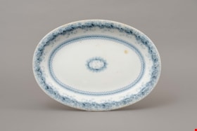
platter
https://search.heritageburnaby.ca/link/museumartifact83513
- Repository
- Burnaby Village Museum
- Accession Code
- BV013.22.1
- Description
- Serving platter, 16 X 12 inches. Made by J & G Meakin, Hanley, England. It is a [C]haplet patern. Blue patern with raised dots around the top edge. The patern is raised on the short sides of the oval. There is a chip on the inside of the bottom surface. "21 is pressed into the underside.
- Object History
- This platter was handed down from Martha Love through three generations to the donor.
- Reference
- http://en.wikipedia.org/wiki/J._%26_G._Meakin - short history of J & G Meakin.
- Maker
- J. & G. Meakin Limited
- Country Made
- England
- Site/City Made
- Hanley
- Historic Neighbourhood
- East Burnaby (Historic Neighbourhood)
- Planning Study Area
- Cariboo-Armstrong Area
Images
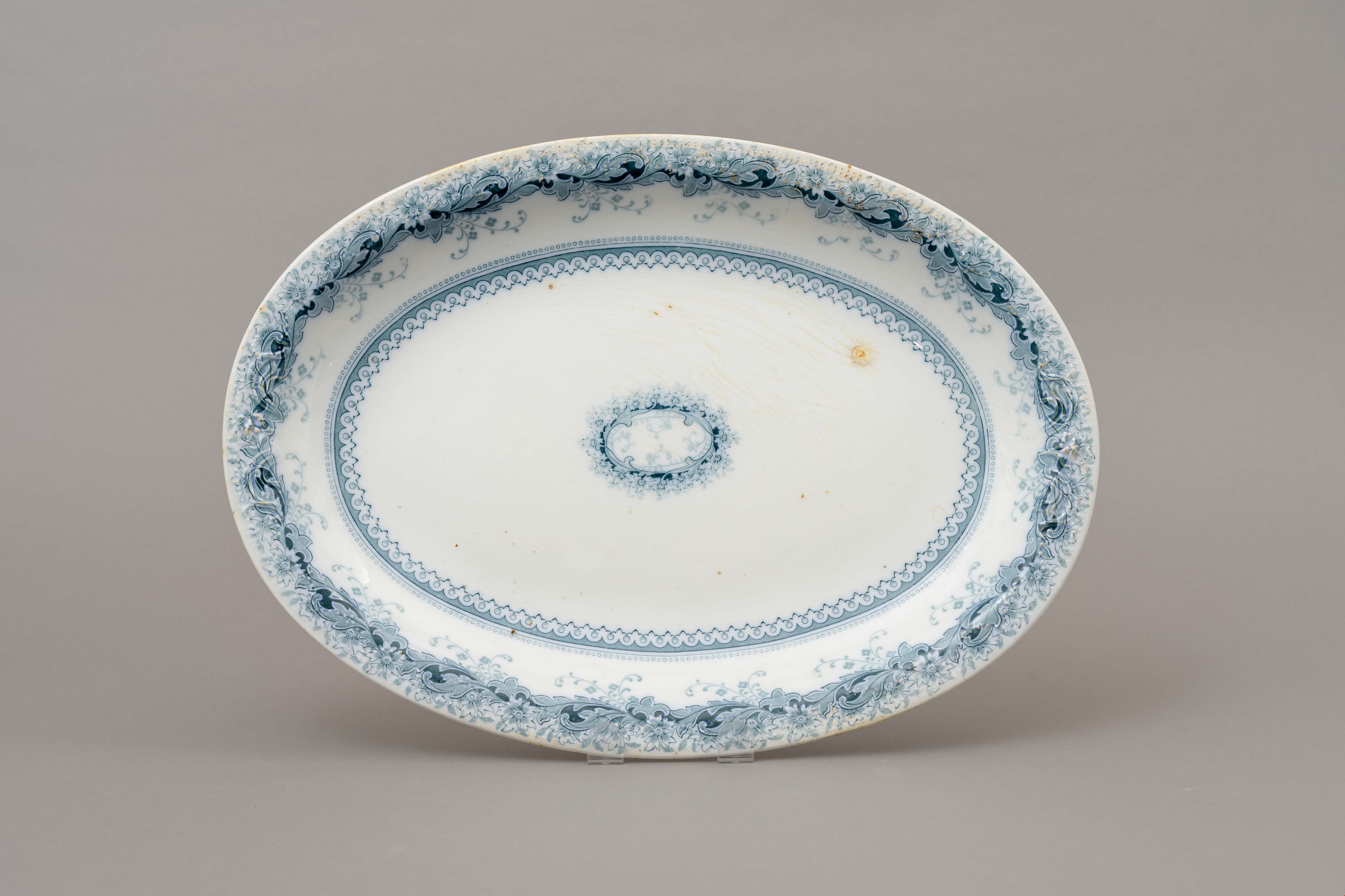
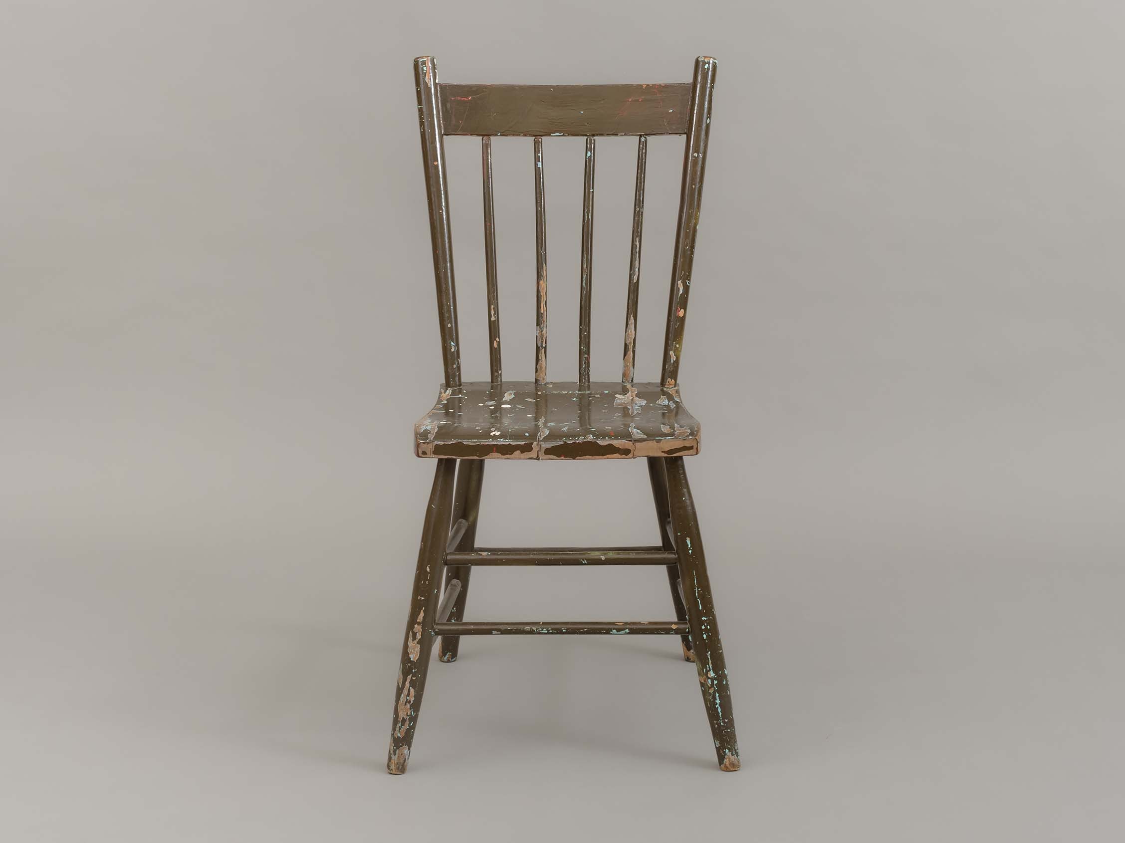
dining chair
https://search.heritageburnaby.ca/link/museumartifact90002
- Repository
- Burnaby Village Museum
- Accession Code
- BV019.8.15
- Description
- dining chair; side chair; brown painted wood; chair back has four vertical spindles; two horizontal stretchers between front and side legs; one horizontal stretcher between back legs.
- Object History
- Object used in the dining room of the Love farmhouse. The layers of paint beneath the brown outer layer reveal past colours of the chair that are documented in BVM photographs of the interior of the Love farmhouse.
- Category
- 02. Furnishings
- Classification
- Furniture - - Seating Furniture
- Object Term
- Chair
- Subjects
- Furniture
- Geographic Access
- Cumberland Street
- Street Address
- 7651 Cumberland Street
- Historic Neighbourhood
- East Burnaby (Historic Neighbourhood)
- Planning Study Area
- Cariboo-Armstrong Area
Images

barometer
https://search.heritageburnaby.ca/link/museumartifact90178
- Repository
- Burnaby Village Museum
- Accession Code
- BV019.8.16
- Description
- barometer; aneroid barometer secured to a carved wood plaque; barometer has a calibrated dial to indicate air pressure; text on dial reads: "VERY DRY", "FAIR", "CHANGE", "RAIN", and "STORMY"; flat metal loop at top of wood plaque for hanging. Dark stained carved wood decorative scroll with finial; has detached from base plaque.
- Object History
- Object used in the Love Farmhouse, currently on site at Burnaby Village Museum.
- Geographic Access
- Cumberland Street
- Street Address
- 7651 Cumberland Street
- Historic Neighbourhood
- East Burnaby (Historic Neighbourhood)
- Planning Study Area
- Cariboo-Armstrong Area
Images

Love House going south on Cumberland Street
https://search.heritageburnaby.ca/link/museumdescription10906
- Repository
- Burnaby Village Museum
- Collection/Fonds
- Burnaby Village Museum fonds
- Description Level
- Item
- Physical Description
- 1 photograph : col. negative ; 35 mm
- Scope and Content
- Photograph of the Love farmhouse moving south on Cumberland Street by little park where kitchen had been placed temporarily. The house is being moved from it's original site at 7651 Cumberland Street to the site of the Burnaby Village Museum.
- Repository
- Burnaby Village Museum
- Collection/Fonds
- Burnaby Village Museum fonds
- Series
- Jesse Love farmhouse series
- Description Level
- Item
- Physical Description
- 1 photograph : col. negative ; 35 mm
- Material Details
- Photograph is part of Film roll "3829" - 20 colour negatives and 18 colour photographs that are a part of a collection described as BV018.41.82
- Scope and Content
- Photograph of the Love farmhouse moving south on Cumberland Street by little park where kitchen had been placed temporarily. The house is being moved from it's original site at 7651 Cumberland Street to the site of the Burnaby Village Museum.
- Subjects
- Buildings - Heritage
- Geographic Access
- Cumberland Street
- Street Address
- 7651 Cumberland Street
- Accession Code
- BV018.41.428
- Access Restriction
- No restrictions
- Reproduction Restriction
- No known restrictions
- Media Type
- Photograph
- Historic Neighbourhood
- East Burnaby (Historic Neighbourhood)
- Planning Study Area
- Cariboo-Armstrong Area
- Related Material
- See BV018.41.82 for File Level Description
- Scan Resolution
- 2400
- Scan Date
- 27-Aug-2019
- Scale
- 100
- Photographer
- Stevens, Colin
- Notes
- Title based on contents of photograph
- Photograph is a part of file level description "Photographic documentation of changes and move" BV018.41.82
Images

William Holmes House
https://search.heritageburnaby.ca/link/landmark736
- Repository
- Burnaby Heritage Planning
- Geographic Access
- North Road
- Brunette River
- Associated Dates
- 1860
- Heritage Value
- William Holmes is considered to be the first non-Native resident of Burnaby. In March, 1860, Holmes acquired the first land title in the area that would become the Municipality of Burnaby. Legally known as Lot One, Block One, this parcel was located on North Road and the Brunette River. The eight-member Holmes family built a log cabin on the lot on a bluff above the river in which they lived for many years until a bigger home was built. The log cabin remained and in 1892 was used as an isolation hospital when a smallpox epidemic hit the lower mainland. Afterwards, local health officials burned the cabin to prevent the spread of disease.
- Planning Study Area
- Cariboo-Armstrong Area
Images

![Jesse Love farmhouse, [between 1893 and 1897] (date of original), copied 1998 thumbnail](/media/hpo/_Data/_BVM_Images/2000/200000450002.jpg?width=280)
Jesse Love farmhouse
https://search.heritageburnaby.ca/link/museumdescription1551
- Repository
- Burnaby Village Museum
- Date
- [between 1893 and 1897] (date of original), copied 1998
- Collection/Fonds
- Love family fonds
- Description Level
- Item
- Physical Description
- 1 photograph : b&w ; 19 x 25 cm print
- Scope and Content
- Photograph of the Jesse Love farmhouse. The Love farmhouse was located at 1390 Cumberland Road (after 1960- address was changed to 7651 Cumberland Street). The Love farmhouse was relocated to the site of the Burnaby Village Museum in 1988 where it was restored to the 1920s era.
- Repository
- Burnaby Village Museum
- Collection/Fonds
- Love family fonds
- Description Level
- Item
- Physical Description
- 1 photograph : b&w ; 19 x 25 cm print
- Scope and Content
- Photograph of the Jesse Love farmhouse. The Love farmhouse was located at 1390 Cumberland Road (after 1960- address was changed to 7651 Cumberland Street). The Love farmhouse was relocated to the site of the Burnaby Village Museum in 1988 where it was restored to the 1920s era.
- Subjects
- Buildings - Residential - Houses
- Geographic Access
- Cumberland Street
- Street Address
- 7651 Cumberland Street
- Accession Code
- BV000.45.2
- Access Restriction
- No restrictions
- Date
- [between 1893 and 1897] (date of original), copied 1998
- Media Type
- Photograph
- Historic Neighbourhood
- East Burnaby (Historic Neighbourhood)
- Planning Study Area
- Cariboo-Armstrong Area
- Scan Resolution
- 600
- Scan Date
- 09-Jun-09
- Scale
- 100
- Notes
- Title based on note on verso of photograph
- Note in pencil on verso of photograph reads: "Jesse Love Farmhouse"
Images
![Jesse Love farmhouse, [between 1893 and 1897] (date of original), copied 1998 thumbnail](/media/hpo/_Data/_BVM_Images/2000/200000450002.jpg)
![Jesse and Martha Love farmhouse, [between 1893 and 1905] (date of original), copied [1988] thumbnail](/media/hpo/_Data/_BVM_Images/1985/1985_3136_0001_001.jpg?width=280)
Jesse and Martha Love farmhouse
https://search.heritageburnaby.ca/link/museumdescription2999
- Repository
- Burnaby Village Museum
- Date
- [between 1893 and 1905] (date of original), copied [1988]
- Collection/Fonds
- Love family fonds
- Description Level
- Item
- Physical Description
- 1 photograph : b&w print ; 9 x 13 cm print
- Scope and Content
- Photograph of the south side of Love Farmhouse prior to the addition of the kitchen. The Love farmhouse was built in 1893 by Jesse Love and was located at 1390 Cumberland Road at the corner of 14th Avenue (after 1960- address was changed to 7651 Cumberland Street). The Love farmhouse was relocated …
- Repository
- Burnaby Village Museum
- Collection/Fonds
- Love family fonds
- Description Level
- Item
- Physical Description
- 1 photograph : b&w print ; 9 x 13 cm print
- Scope and Content
- Photograph of the south side of Love Farmhouse prior to the addition of the kitchen. The Love farmhouse was built in 1893 by Jesse Love and was located at 1390 Cumberland Road at the corner of 14th Avenue (after 1960- address was changed to 7651 Cumberland Street). The Love farmhouse was relocated to the site of the Burnaby Village Museum in 1988 where it was restored to the 1920s era.
- Subjects
- Buildings - Heritage
- Geographic Access
- Cumberland Street
- Street Address
- 7651 Cumberland Street
- Accession Code
- BV985.3136.1
- Access Restriction
- No restrictions
- Reproduction Restriction
- No known restrictions
- Date
- [between 1893 and 1905] (date of original), copied [1988]
- Media Type
- Photograph
- Historic Neighbourhood
- East Burnaby (Historic Neighbourhood)
- Planning Study Area
- Cariboo-Armstrong Area
- Scan Resolution
- 600
- Scan Date
- 16-Jan-24
- Notes
- Title based on content of photograph
- Label on front of photograph reads: "Old home side"
- Label beneath photograph in original album reads:" Old home field"
- 1 b&w copy negative accompanying
Images
![Jesse and Martha Love farmhouse, [between 1893 and 1905] (date of original), copied [1988] thumbnail](/media/hpo/_Data/_BVM_Images/1985/1985_3136_0001_001.jpg)
![Jesse Love feeding chickens, [1893] (date of original), copied [1988] thumbnail](/media/hpo/_Data/_BVM_Images/2018/2018_0041_0197_001.jpg?width=280)
Jesse Love feeding chickens
https://search.heritageburnaby.ca/link/museumdescription9956
- Repository
- Burnaby Village Museum
- Date
- [1893] (date of original), copied [1988]
- Collection/Fonds
- Burnaby Village Museum fonds
- Description Level
- Item
- Physical Description
- 1 photograph : col. slide ; 35 mm
- Scope and Content
- Photograph of Jesse Love feeding chickens outside the Love farmhouse which was located on the north east section of District Lot 25, at the corner of Cumberland Road and Fourteenth Avenue. The house was relocated to the Burnaby Village Museum site in 1988 and restored to the 1920s era.
- Repository
- Burnaby Village Museum
- Collection/Fonds
- Burnaby Village Museum fonds
- Series
- Jesse Love farmhouse series
- Subseries
- Love family photographs subseries
- Description Level
- Item
- Physical Description
- 1 photograph : col. slide ; 35 mm
- Scope and Content
- Photograph of Jesse Love feeding chickens outside the Love farmhouse which was located on the north east section of District Lot 25, at the corner of Cumberland Road and Fourteenth Avenue. The house was relocated to the Burnaby Village Museum site in 1988 and restored to the 1920s era.
- Subjects
- Agriculture - Poultry
- Animals - Poultry
- Names
- Love, Jesse, 1849-1928
- Geographic Access
- Cumberland Street
- Accession Code
- BV018.41.197
- Access Restriction
- No restrictions
- Reproduction Restriction
- May be restricted by third party rights
- Date
- [1893] (date of original), copied [1988]
- Media Type
- Photograph
- Historic Neighbourhood
- East Burnaby (Historic Neighbourhood)
- Planning Study Area
- Cariboo-Armstrong Area
- Scan Resolution
- 2400
- Scan Date
- 4-Mar-2019
- Scale
- 100
- Notes
- Title based on content of photograph
Images
![Jesse Love feeding chickens, [1893] (date of original), copied [1988] thumbnail](/media/hpo/_Data/_BVM_Images/2018/2018_0041_0197_001.jpg)
![Jesse Love's Fruit Farm, Burnaby, BC, [1900] thumbnail](/media/hpo/_Data/_Archives_Images/_Unrestricted/001/022-004.jpg?width=280)
Jesse Love's Fruit Farm, Burnaby, BC
https://search.heritageburnaby.ca/link/archivedescription34501
- Repository
- City of Burnaby Archives
- Date
- [1900]
- Collection/Fonds
- Burnaby Historical Society fonds
- Description Level
- Item
- Physical Description
- 1 photograph : sepia ; 12.8 x 17.8 cm mounted on cardboard 14.7 x 19.8 cm
- Scope and Content
- Photograph of members of the Love family kneeling in a strawberry field. Left to right: Jesse Love (father), Leonard, Phoebe, Martha, Minnie, Martha Love (mother), and Sarah. The small building at the extreme left of the picture was George Love's (oldest of the Love's children) first sash and doo…
- Repository
- City of Burnaby Archives
- Date
- [1900]
- Collection/Fonds
- Burnaby Historical Society fonds
- Subseries
- Photographs subseries
- Physical Description
- 1 photograph : sepia ; 12.8 x 17.8 cm mounted on cardboard 14.7 x 19.8 cm
- Description Level
- Item
- Record No.
- 022-004
- Access Restriction
- No restrictions
- Reproduction Restriction
- No known restrictions
- Accession Number
- BHS2007-04
- Scope and Content
- Photograph of members of the Love family kneeling in a strawberry field. Left to right: Jesse Love (father), Leonard, Phoebe, Martha, Minnie, Martha Love (mother), and Sarah. The small building at the extreme left of the picture was George Love's (oldest of the Love's children) first sash and door outlet. He later built Love's Sash and Door Factory on the south side of Edmonds Street just west of 6th Street. The original farm was located in East Burnaby, on Cumberland Road. In 1988, this house was moved to the site of the Burnaby Village Museum at Deer Lake Avenue.
- Names
- Love, Jesse, 1849-1928
- Love, Leonard
- Brandrith, Martha Dorothy “Dot” Love
- Love, Martha Leonard, 1858-1920
- McKenzie, Edith Minnie Love
- Feedham, Phoebe Leonard Love
- Parker, Sarah Maria Love
- Media Type
- Photograph
- Photographer
- Cooksley, William Thomas
- Notes
- Annotation bottom of the photograph reads, "Jesse Love's Fruit Farm, Burnaby, BC"
- Geographic Access
- Cumberland Street
- Street Address
- 6501 Deer Lake Avenue
- Historic Neighbourhood
- East Burnaby (Historic Neighbourhood)
- Planning Study Area
- Cariboo-Armstrong Area
Images
![Jesse Love's Fruit Farm, Burnaby, BC, [1900] thumbnail](/media/hpo/_Data/_Archives_Images/_Unrestricted/001/022-004.jpg)
![Jesse Love farmhouse, [between 1900 and 1905] (date of original), copied 1998 thumbnail](/media/hpo/_Data/_BVM_Images/2000/200000450001.jpg?width=280)
Jesse Love farmhouse
https://search.heritageburnaby.ca/link/museumdescription1550
- Repository
- Burnaby Village Museum
- Date
- [between 1900 and 1905] (date of original), copied 1998
- Collection/Fonds
- Love family fonds
- Description Level
- Item
- Physical Description
- 1 photograph : b&w ; 18 x 25 cm print
- Scope and Content
- Photograph of two women standing by the wooden picket fence that surrounds the Jesse Love Farmhouse (very high pickets have been used for part of the fence).The Love farmhouse was located at 1390 Cumberland Road (after 1960- address was changed to 7651 Cumberland Street). The Love farmhouse was rel…
- Repository
- Burnaby Village Museum
- Collection/Fonds
- Love family fonds
- Description Level
- Item
- Physical Description
- 1 photograph : b&w ; 18 x 25 cm print
- Scope and Content
- Photograph of two women standing by the wooden picket fence that surrounds the Jesse Love Farmhouse (very high pickets have been used for part of the fence).The Love farmhouse was located at 1390 Cumberland Road (after 1960- address was changed to 7651 Cumberland Street). The Love farmhouse was relocated to the site of the Burnaby Village Museum in 1988 where it was restored to the 1920s era.
- Subjects
- Buildings - Heritage
- Structures - Fences
- Geographic Access
- Cumberland Street
- Street Address
- 7651 Cumberland Street
- Accession Code
- BV000.45.1
- Access Restriction
- No restrictions
- Date
- [between 1900 and 1905] (date of original), copied 1998
- Media Type
- Photograph
- Historic Neighbourhood
- East Burnaby (Historic Neighbourhood)
- Planning Study Area
- Cariboo-Armstrong Area
- Scan Resolution
- 600
- Scan Date
- 09-Jun-09
- Scale
- 100
- Notes
- Title based on contents of photograph
- Note in pencil on verso of photograph reads: "Jesse Love Farmhouse Burnaby BC"
- See also photograph: BV018.41.146
Images
![Jesse Love farmhouse, [between 1900 and 1905] (date of original), copied 1998 thumbnail](/media/hpo/_Data/_BVM_Images/2000/200000450001.jpg)
![Jesse Love farmhouse, [between 1900 and 1905] (date of original), copied [1988] thumbnail](/media/hpo/_Data/_BVM_Images/2018/2018_0041_0199_001.jpg?width=280)
Jesse Love farmhouse
https://search.heritageburnaby.ca/link/museumdescription9958
- Repository
- Burnaby Village Museum
- Date
- [between 1900 and 1905] (date of original), copied [1988]
- Collection/Fonds
- Burnaby Village Museum fonds
- Description Level
- Item
- Physical Description
- 1 photograph : col. slide ; 35 mm
- Scope and Content
- Photograph of two women standing by the wooden picket fence that surrounds the Jesse Love farmhouse (very high pickets have been used for part of the fence).The Love farmhouse was located at 1390 Cumberland Road (after 1960- address was changed to 7651 Cumberland Street). The Love farmhouse was rel…
- Repository
- Burnaby Village Museum
- Collection/Fonds
- Burnaby Village Museum fonds
- Series
- Jesse Love farmhouse series
- Subseries
- Love family photographs subseries
- Description Level
- Item
- Physical Description
- 1 photograph : col. slide ; 35 mm
- Scope and Content
- Photograph of two women standing by the wooden picket fence that surrounds the Jesse Love farmhouse (very high pickets have been used for part of the fence).The Love farmhouse was located at 1390 Cumberland Road (after 1960- address was changed to 7651 Cumberland Street). The Love farmhouse was relocated to the site of the Burnaby Village Museum in 1988 where it was restored to the 1920s era.
- Geographic Access
- Cumberland Street
- Street Address
- 7651 Cumberland Street
- Accession Code
- BV018.41.199
- Access Restriction
- No restrictions
- Reproduction Restriction
- May be restricted by third party rights
- Date
- [between 1900 and 1905] (date of original), copied [1988]
- Media Type
- Photograph
- Historic Neighbourhood
- East Burnaby (Historic Neighbourhood)
- Planning Study Area
- Cariboo-Armstrong Area
- Scan Resolution
- 2400
- Scan Date
- 4-Mar-2019
- Scale
- 100
- Notes
- Title based on content of photograph
Images
![Jesse Love farmhouse, [between 1900 and 1905] (date of original), copied [1988] thumbnail](/media/hpo/_Data/_BVM_Images/2018/2018_0041_0199_001.jpg)
![Four generations, [between 1900 and 1909] (date of original), copied [1988] thumbnail](/media/hpo/_Data/_BVM_Images/2018/2018_0041_0200_001.jpg?width=280)
Four generations
https://search.heritageburnaby.ca/link/museumdescription9959
- Repository
- Burnaby Village Museum
- Date
- [between 1900 and 1909] (date of original), copied [1988]
- Collection/Fonds
- Burnaby Village Museum fonds
- Description Level
- Item
- Physical Description
- 1 photograph : col. slide ; 35 mm
- Scope and Content
- Photograph of (left to right) Annn (Annie) Elizabeth Whiting (nee Love), her mother, Mrs. Martha Love and her grandfather George Leonard and her daughter Edith Whiting.The group is gathered together outside in a yard with a fence of what might be the home of Jesse and Martha Love.
- Repository
- Burnaby Village Museum
- Collection/Fonds
- Burnaby Village Museum fonds
- Series
- Jesse Love farmhouse series
- Subseries
- Love family photographs subseries
- Description Level
- Item
- Physical Description
- 1 photograph : col. slide ; 35 mm
- Scope and Content
- Photograph of (left to right) Annn (Annie) Elizabeth Whiting (nee Love), her mother, Mrs. Martha Love and her grandfather George Leonard and her daughter Edith Whiting.The group is gathered together outside in a yard with a fence of what might be the home of Jesse and Martha Love.
- Subjects
- Structures - Fences
- Names
- Leonard, George
- Love Family
- Whiting, Annie Elizabeth Love
- Clayton, Edith Annie Whiting
- Stanley, Esther Love
- Love, Martha Leonard, 1858-1920
- Barnes, Hannah Victoria "Girlie" Love
- Geographic Access
- Cumberland Street
- Street Address
- 7651 Cumberland Street
- Accession Code
- BV018.41.200
- Access Restriction
- No restrictions
- Reproduction Restriction
- May be restricted by third party rights
- Date
- [between 1900 and 1909] (date of original), copied [1988]
- Media Type
- Photograph
- Historic Neighbourhood
- East Burnaby (Historic Neighbourhood)
- Planning Study Area
- Cariboo-Armstrong Area
- Scan Resolution
- 2400
- Scan Date
- 4-Mar-2019
- Scale
- 100
- Notes
- Title based on contents of photograph
Images
![Four generations, [between 1900 and 1909] (date of original), copied [1988] thumbnail](/media/hpo/_Data/_BVM_Images/2018/2018_0041_0200_001.jpg)
![Love farmhouse in winter, [1900] (date of original), copied [1988] thumbnail](/media/hpo/_Data/_BVM_Images/2018/2018_0041_0202_001.jpg?width=280)
Love farmhouse in winter
https://search.heritageburnaby.ca/link/museumdescription9960
- Repository
- Burnaby Village Museum
- Date
- [1900] (date of original), copied [1988]
- Collection/Fonds
- Burnaby Village Museum fonds
- Description Level
- Item
- Physical Description
- 1 photograph : col. slide ; 35 mm
- Scope and Content
- Photograph of the Love family farmhouse located at 1390 Cumberland Road (later renumbered 7651 Cumberland Street), East Burnaby. A mature conifer tree sits next to the house, both are covered in snow. The house was built by Jesse Love with the help of George Salt in 1893. In 1988, this house was mo…
- Repository
- Burnaby Village Museum
- Collection/Fonds
- Burnaby Village Museum fonds
- Series
- Jesse Love farmhouse series
- Subseries
- Love family photographs subseries
- Description Level
- Item
- Physical Description
- 1 photograph : col. slide ; 35 mm
- Scope and Content
- Photograph of the Love family farmhouse located at 1390 Cumberland Road (later renumbered 7651 Cumberland Street), East Burnaby. A mature conifer tree sits next to the house, both are covered in snow. The house was built by Jesse Love with the help of George Salt in 1893. In 1988, this house was moved to the site of the Burnaby Village Museum at 6501 Deer Lake Avenue where it was restored to the 1920s era.
- Geographic Access
- Cumberland Street
- Street Address
- 7651 Cumberland Street
- Accession Code
- BV018.41.202
- Access Restriction
- No restrictions
- Reproduction Restriction
- May be restricted by third party rights
- Date
- [1900] (date of original), copied [1988]
- Media Type
- Photograph
- Historic Neighbourhood
- East Burnaby (Historic Neighbourhood)
- Planning Study Area
- Cariboo-Armstrong Area
- Scan Resolution
- 2400
- Scan Date
- 4-Mar-2019
- Scale
- 100
- Notes
- Title based on contents of photograph
- Annotation on bottom of photograph reads: "1390 Cumberland Rd, the old home"
Images
![Love farmhouse in winter, [1900] (date of original), copied [1988] thumbnail](/media/hpo/_Data/_BVM_Images/2018/2018_0041_0202_001.jpg)
Copies of Esther (Love) Stanley photograph album pages
https://search.heritageburnaby.ca/link/museumdescription10015
- Repository
- Burnaby Village Museum
- Date
- [1900-1930] (date of originals), copied 1988
- Collection/Fonds
- Burnaby Village Museum fonds
- Description Level
- File
- Physical Description
- 25 photographs : b&w negatives ; 35 mm
- Scope and Content
- Photographs of pages from a photograph album belonging to Esther (Love) Stanley. Each photograph includes five to nine images per page as per the arrangement of the original album.
- Repository
- Burnaby Village Museum
- Collection/Fonds
- Burnaby Village Museum fonds
- Series
- Jesse Love farmhouse series
- Subseries
- Love family photographs subseries
- Description Level
- File
- Physical Description
- 25 photographs : b&w negatives ; 35 mm
- Scope and Content
- Photographs of pages from a photograph album belonging to Esther (Love) Stanley. Each photograph includes five to nine images per page as per the arrangement of the original album.
- Subjects
- Buildings - Heritage
- Geographic Access
- Cumberland Street
- Street Address
- 7651 Cumberland Street
- Accession Code
- BV018.41.194
- Access Restriction
- No restrictions
- Reproduction Restriction
- May be restricted by third party rights
- Date
- [1900-1930] (date of originals), copied 1988
- Media Type
- Photograph
- Historic Neighbourhood
- East Burnaby (Historic Neighbourhood)
- Planning Study Area
- Cariboo-Armstrong Area
- Notes
- Title based on contents of photograph
- 21 b&w copy prints accompanying
Copies of Esther (Love) Stanley photograph album pages
https://search.heritageburnaby.ca/link/museumdescription10016
- Repository
- Burnaby Village Museum
- Date
- [1900-1930] (date of originals), copied 1989
- Collection/Fonds
- Burnaby Village Museum fonds
- Description Level
- File
- Physical Description
- 37 photographs : b&w negatives ; 35 mm
- Scope and Content
- Photographs of pages from a photograph album belonging to Esther (Love) Stanley. Each photograph includes one to four images per page as per the arrangement of the original album.
- Repository
- Burnaby Village Museum
- Collection/Fonds
- Burnaby Village Museum fonds
- Series
- Jesse Love farmhouse series
- Subseries
- Love family photographs subseries
- Description Level
- File
- Physical Description
- 37 photographs : b&w negatives ; 35 mm
- Scope and Content
- Photographs of pages from a photograph album belonging to Esther (Love) Stanley. Each photograph includes one to four images per page as per the arrangement of the original album.
- Subjects
- Buildings - Heritage
- Geographic Access
- Cumberland Street
- Street Address
- 7651 Cumberland Street
- Accession Code
- BV018.41.195
- Access Restriction
- No restrictions
- Reproduction Restriction
- May be restricted by third party rights
- Date
- [1900-1930] (date of originals), copied 1989
- Media Type
- Photograph
- Historic Neighbourhood
- East Burnaby (Historic Neighbourhood)
- Planning Study Area
- Cariboo-Armstrong Area
- Notes
- Title based on contents of photograph
- 39 b&w copy prints accompanying (two copy prints are close ups from negatives)
![Brunette River, [1907] thumbnail](/media/hpo/_Data/_Archives_Images/_Unrestricted/126/133-001.jpg?width=280)
Brunette River
https://search.heritageburnaby.ca/link/archivedescription34770
- Repository
- City of Burnaby Archives
- Date
- [1907]
- Collection/Fonds
- Burnaby Historical Society fonds
- Description Level
- Item
- Physical Description
- 1 photograph : sepia ; 12.7 x 17.8 cm
- Scope and Content
- Photograph of a man, a woman, five children, and a dog wading in the Brunette River.
- Repository
- City of Burnaby Archives
- Date
- [1907]
- Collection/Fonds
- Burnaby Historical Society fonds
- Subseries
- Gerald Davy subseries
- Physical Description
- 1 photograph : sepia ; 12.7 x 17.8 cm
- Description Level
- Item
- Record No.
- 133-001
- Access Restriction
- No restrictions
- Reproduction Restriction
- No known restrictions
- Accession Number
- BHS1985-01
- Scope and Content
- Photograph of a man, a woman, five children, and a dog wading in the Brunette River.
- Media Type
- Photograph
- Photographer
- Davy, Gerald
- Notes
- Title based on contents of photograph
- Geographic Access
- Brunette River
- Planning Study Area
- Burnaby Lake Area
- Cariboo-Armstrong Area
Images
![Brunette River, [1907] thumbnail](/media/hpo/_Data/_Archives_Images/_Unrestricted/126/133-001.jpg)
![Brunette River, [1907] thumbnail](/media/hpo/_Data/_Archives_Images/_Unrestricted/126/133-005.jpg?width=280)
Brunette River
https://search.heritageburnaby.ca/link/archivedescription34774
- Repository
- City of Burnaby Archives
- Date
- [1907]
- Collection/Fonds
- Burnaby Historical Society fonds
- Description Level
- Item
- Physical Description
- 1 photograph : sepia ; 12.6 x 17.5 cm
- Scope and Content
- Photograph of the Brunette River.
- Repository
- City of Burnaby Archives
- Date
- [1907]
- Collection/Fonds
- Burnaby Historical Society fonds
- Subseries
- Gerald Davy subseries
- Physical Description
- 1 photograph : sepia ; 12.6 x 17.5 cm
- Description Level
- Item
- Record No.
- 133-005
- Access Restriction
- No restrictions
- Reproduction Restriction
- No known restrictions
- Accession Number
- BHS1985-01
- Scope and Content
- Photograph of the Brunette River.
- Media Type
- Photograph
- Photographer
- Davy, Gerald
- Notes
- Title based on contents of photograph
- Geographic Access
- Brunette River
- Planning Study Area
- Burnaby Lake Area
- Cariboo-Armstrong Area
Images
![Brunette River, [1907] thumbnail](/media/hpo/_Data/_Archives_Images/_Unrestricted/126/133-005.jpg)