Narrow Results By
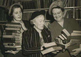
Grace McGill inside McGill Annex
https://search.heritageburnaby.ca/link/archivedescription36134
- Repository
- City of Burnaby Archives
- Date
- May 15, 1951
- Collection/Fonds
- Burnaby Historical Society fonds
- Description Level
- Item
- Physical Description
- 1 photograph : b&w ; 12 x 17 cm, mounted on board 15 x 40.5 cm
- Scope and Content
- Photograph of (Mrs.) William Beck, Grace McGill, and Lois Stevenson each holding stacks of books at the opening of the McGill Annex.
- Repository
- City of Burnaby Archives
- Date
- May 15, 1951
- Collection/Fonds
- Burnaby Historical Society fonds
- Physical Description
- 1 photograph : b&w ; 12 x 17 cm, mounted on board 15 x 40.5 cm
- Description Level
- Item
- Record No.
- 225-001
- Access Restriction
- No restrictions
- Reproduction Restriction
- Reproduce for fair dealing purposes only
- Accession Number
- BHS1989-22
- Scope and Content
- Photograph of (Mrs.) William Beck, Grace McGill, and Lois Stevenson each holding stacks of books at the opening of the McGill Annex.
- Subjects
- Buildings - Civic - Libraries
- Media Type
- Photograph
- Photographer
- Cunningham, Bill
- Notes
- Title based on contents of photograph
- Photograph was originally mounted in a booklet style folder, with a stamp on the recto that reads: "BURNABY PUBLIC LIBRARY FOR REFERENCE USE IN LIBRARY ONLY" a stamp in the interior that reads: "COMPLIMENTS VANCOUVER DAILY PROVINCE" and a stamp on the verso that reads: "Bill Cunningham, Vancouver, B.C."
- Geographic Access
- Albert Street
- Street Address
- 4595 Albert Street
- Historic Neighbourhood
- Capitol Hill (Historic Neighbourhood)
- Planning Study Area
- Capitol Hill Area
Images


Howard Avenue School site
https://search.heritageburnaby.ca/link/museumdescription11124
- Repository
- Burnaby Village Museum
- Date
- March 24, 1915
- Collection/Fonds
- Ronald G. Scobbie collection
- Description Level
- Item
- Physical Description
- 1 survey plan : blueprint on paper ; 56 x 54 cm
- Scope and Content
- Survey plan of "Howard Avenue School Site" "Burnaby Municipality", "Being Lots 1-5 and 14-18 Inc. Block 5 of the Subd. of Easterly 3/4 of Lot 127. Group 1, New Westminster District";
- Repository
- Burnaby Village Museum
- Collection/Fonds
- Ronald G. Scobbie collection
- Description Level
- Item
- Physical Description
- 1 survey plan : blueprint on paper ; 56 x 54 cm
- Material Details
- Scale: 40 feet = 1 inch
- Scope and Content
- Survey plan of "Howard Avenue School Site" "Burnaby Municipality", "Being Lots 1-5 and 14-18 Inc. Block 5 of the Subd. of Easterly 3/4 of Lot 127. Group 1, New Westminster District";
- Creator
- McGugan, Donald Johnston
- Subjects
- Buildings - Schools
- Names
- Howard Avenue School
- Responsibility
- Burnett and McGugan B.C. Land Surveyors, New Westminster
- Geographic Access
- Howard Avenue
- Georgia Street
- Accession Code
- BV003.83.4
- Access Restriction
- No restrictions
- Reproduction Restriction
- No known restrictions
- Date
- March 24, 1915
- Media Type
- Cartographic Material
- Historic Neighbourhood
- Capitol Hill (Historic Neighbourhood)
- Planning Study Area
- Capitol Hill Area
- Scan Resolution
- 440
- Scan Date
- 22-Dec-2020
- Scale
- 100
- Notes
- Title based on contents of plan
- Oath in bottom left corner reads: "I, D.J. McGugan...and did personally superintend the survey..." "...completed on the 24th day of March 1915"; signed "D.J. McGugan", notarized on April 12th, 1915 by "R. Chapman"
- handwritten on back, "1754"
