Narrow Results By
Subject
- Advertising Medium - Signs and Signboards 3
- Aerial Photographs 4
- Buildings - Civic 3
- Buildings - Civic - Libraries 1
- Buildings - Commercial 1
- Buildings - Commercial - Hotels and Motels 1
- Buildings - Commercial - Restaurants 2
- Buildings - Industrial 2
- Buildings - Industrial - Refineries 2
- Buildings - Recreational 7
- Buildings - Schools - Universities and Colleges 24
- Ceremonies - Graduations 1

Barnet Neighbourhood
https://search.heritageburnaby.ca/link/landmark716
- Repository
- Burnaby Heritage Planning
- Associated Dates
- 1889-1904
- Heritage Value
- The North Pacific Lumber Company in Barnet was one of Burnaby's first industrial developments and one of the largest in the British Empire. Partners James MacLaren and Frank Ross built the mill in 1889 (activated in 1899) as a requirement for obtaining 84,000 acres of timber rights in northern BC. Due to the mill's isolation, the firm built homes for its employees with families and bunkhouses for the bachelors which separated Caucasian workers from Chinese and Sikh workers. Barnet became a distinct company town with its own general store, school, post office, community hall and telephone exchange.
- Historic Neighbourhood
- Barnet (Historic Neighbourhood)
- Planning Study Area
- Burnaby Mountain Area
Images


Barnet School
https://search.heritageburnaby.ca/link/landmark719
- Repository
- Burnaby Heritage Planning
- Geographic Access
- Barnet Road
- Associated Dates
- 1899
- Heritage Value
- When the Barnet Mill began operations in 1899, the mill authorities opened a small school to accommodate the children of employees. The school was located in a remodelled harness-room beside the mill and Miss Phoebe Spragge was the first teacher at a salary of $40.00 per month. By 1907, the school had been moved to a purpose-built building where it remained in operation until the early 1950s.
- Historic Neighbourhood
- Barnet (Historic Neighbourhood)
- Planning Study Area
- Burnaby Mountain Area
- Street Address
- 7820 Barnet Road
Images


Burnaby Mountain Neighbourhood
https://search.heritageburnaby.ca/link/landmark792
- Repository
- Burnaby Heritage Planning
- Associated Dates
- 1955-2008
- Heritage Value
- Burnaby Mountain had been dedicated as park in 1942, however the original park boundaries were reconsidered in 1952 with the development of the Trans Mountain Pipeline. Although the boundaries were adjusted to accommodate this project, significant conservation and park lands were left untouched. When, in 1962, the government of British Columbia determined the need for additional post-secondary facilities, Burnaby Mountain was chosen as the site for the new Simon Fraser University which opened in 1965. As early as 1964, the idea of establishing a townsite around the university had been discussed by Burnaby, but it was not until the mid-1990s that the idea came to fruition and by the early 2000s, a new housing development know as the UniverCity took shape on the mountain adjacent to the university.
- Historic Neighbourhood
- Barnet (Historic Neighbourhood)
- Planning Study Area
- Burnaby Mountain Area
Images

![Aliceville Hotel, [1892] thumbnail](/media/hpo/_Data/_Archives_Images/_Unrestricted/371/421-001.jpg?width=280)
Aliceville Hotel
https://search.heritageburnaby.ca/link/archivedescription38369
- Repository
- City of Burnaby Archives
- Date
- [1892]
- Collection/Fonds
- Burnaby Historical Society fonds
- Description Level
- Item
- Physical Description
- 1 photograph : b&w ; 10 x 12.5 cm
- Scope and Content
- Photograph of the Aliceville Hotel at Burrard Inlet which was built in 1892. On the back of the photograph, a map showing the hotel's location in relation to Hastings Street and North Road has been sketched in pencil.
- Repository
- City of Burnaby Archives
- Date
- [1892]
- Collection/Fonds
- Burnaby Historical Society fonds
- Subseries
- Photographs subseries
- Physical Description
- 1 photograph : b&w ; 10 x 12.5 cm
- Description Level
- Item
- Record No.
- 421-001
- Access Restriction
- No restrictions
- Reproduction Restriction
- No known restrictions
- Accession Number
- BHS2001-10
- Scope and Content
- Photograph of the Aliceville Hotel at Burrard Inlet which was built in 1892. On the back of the photograph, a map showing the hotel's location in relation to Hastings Street and North Road has been sketched in pencil.
- Names
- Aliceville Hotel
- Media Type
- Photograph
- Notes
- Title based on contents of photograph
- Geographic Access
- Hastings Street
- Barnet Road
- Street Address
- 9951 Barnet Road
- Planning Study Area
- Burnaby Mountain Area
Images
![Aliceville Hotel, [1892] thumbnail](/media/hpo/_Data/_Archives_Images/_Unrestricted/371/421-001.jpg)
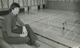
Barbara Robertson
https://search.heritageburnaby.ca/link/archivedescription46339
- Repository
- City of Burnaby Archives
- Date
- March 6, 1978
- Collection/Fonds
- Columbian Newspaper collection
- Description Level
- Item
- Physical Description
- 1 photograph : b&w ; 14.5 x 24 cm
- Scope and Content
- Photograph of the Women's Athletic Coordinator at Simon Fraser University, Barbara Robertson, sitting on the bleachers in the Simon Fraser University gymnasium.
- Repository
- City of Burnaby Archives
- Date
- March 6, 1978
- Collection/Fonds
- Columbian Newspaper collection
- Physical Description
- 1 photograph : b&w ; 14.5 x 24 cm
- Description Level
- Item
- Record No.
- 480-1227
- Access Restriction
- No restrictions
- Reproduction Restriction
- No restrictions
- Accession Number
- 2003-02
- Scope and Content
- Photograph of the Women's Athletic Coordinator at Simon Fraser University, Barbara Robertson, sitting on the bleachers in the Simon Fraser University gymnasium.
- Subjects
- Occupations - Teachers
- Persons - Athletes
- Media Type
- Photograph
- Photographer
- Hodge, Craig
- Notes
- Title based on contents of photograph
- Geographic Access
- University Drive
- Street Address
- 8888 University Drive
- Planning Study Area
- Burnaby Mountain Area
Images


Barnet Beach
https://search.heritageburnaby.ca/link/archivedescription93650
- Repository
- City of Burnaby Archives
- Date
- November 20, 1977
- Collection/Fonds
- Burnaby Public Library Contemporary Visual Archive Project
- Description Level
- Item
- Physical Description
- 1 photograph : b&w ; 12.5 x 17.5 cm
- Scope and Content
- Photograph of Burrard Inlet, taken facing west from Barnet Beach. Capitol Hill and the Second Narrows Bridge are visible in the distance.
- Repository
- City of Burnaby Archives
- Date
- November 20, 1977
- Collection/Fonds
- Burnaby Public Library Contemporary Visual Archive Project
- Physical Description
- 1 photograph : b&w ; 12.5 x 17.5 cm
- Description Level
- Item
- Record No.
- 556-607
- Access Restriction
- No restrictions
- Reproduction Restriction
- Reproduce for fair dealing purposes only
- Accession Number
- 2017-57
- Scope and Content
- Photograph of Burrard Inlet, taken facing west from Barnet Beach. Capitol Hill and the Second Narrows Bridge are visible in the distance.
- Media Type
- Photograph
- Photographer
- Chapman, Fred
- Notes
- Title taken from project information form
- Accompanied by a project information form and 1 photograph (b&w negative ; 9.5 x 12.5 cm)
- BPL no. 57
- Geographic Access
- Barnet Marine Park
- Historic Neighbourhood
- Barnet (Historic Neighbourhood)
- Planning Study Area
- Burnaby Mountain Area
Images


Barnet Rifle Club
https://search.heritageburnaby.ca/link/archivedescription79712
- Repository
- City of Burnaby Archives
- Date
- September 12, 1976
- Collection/Fonds
- Burnaby Public Library Contemporary Visual Archive Project
- Description Level
- Item
- Physical Description
- 1 photograph : b&w ; 11 x 16 cm mounted on cardboard
- Scope and Content
- Photograph shows the sign at the entrance to the Barnet Rifle Club and the Rifle Range at 8550 Barnet Road.
- Repository
- City of Burnaby Archives
- Date
- September 12, 1976
- Collection/Fonds
- Burnaby Public Library Contemporary Visual Archive Project
- Physical Description
- 1 photograph : b&w ; 11 x 16 cm mounted on cardboard
- Description Level
- Item
- Record No.
- 556-396
- Access Restriction
- No restrictions
- Reproduction Restriction
- Reproduce for fair dealing purposes only
- Accession Number
- 2013-13
- Scope and Content
- Photograph shows the sign at the entrance to the Barnet Rifle Club and the Rifle Range at 8550 Barnet Road.
- Names
- Barnet Rifle Club
- Media Type
- Photograph
- Notes
- Scope note taken directly from BPL photograph description.
- 1 b&w copy negative : 10 x 12.5 cm accompanying
- Photographers identified by surnames only: Carr and Vardeman
- Geographic Access
- Barnet Road
- Street Address
- 8550 Barnet Road
- Historic Neighbourhood
- Barnet (Historic Neighbourhood)
- Planning Study Area
- Burnaby Mountain Area
Images


Barnet Rifle Club
https://search.heritageburnaby.ca/link/archivedescription79713
- Repository
- City of Burnaby Archives
- Date
- September, 1976
- Collection/Fonds
- Burnaby Public Library Contemporary Visual Archive Project
- Description Level
- Item
- Physical Description
- 1 photograph : b&w ; 11 x 16 cm mounted on cardboard
- Scope and Content
- Photograph shows a man ascending the steps of the Barnet Rifle Club Clubhouse.
- Repository
- City of Burnaby Archives
- Date
- September, 1976
- Collection/Fonds
- Burnaby Public Library Contemporary Visual Archive Project
- Physical Description
- 1 photograph : b&w ; 11 x 16 cm mounted on cardboard
- Description Level
- Item
- Record No.
- 556-397
- Access Restriction
- No restrictions
- Reproduction Restriction
- Reproduce for fair dealing purposes only
- Accession Number
- 2013-13
- Scope and Content
- Photograph shows a man ascending the steps of the Barnet Rifle Club Clubhouse.
- Names
- Barnet Rifle Club
- Media Type
- Photograph
- Notes
- Scope note taken directly from BPL photograph description.
- 1 b&w copy negative : 10 x 12.5 cm accompanying
- Photographers identified by surnames only: Carr and Vardeman
- Geographic Access
- Barnet Road
- Street Address
- 8550 Barnet Road
- Historic Neighbourhood
- Barnet (Historic Neighbourhood)
- Planning Study Area
- Burnaby Mountain Area
Images


Barnet Rifle Club
https://search.heritageburnaby.ca/link/archivedescription79714
- Repository
- City of Burnaby Archives
- Date
- September 12, 1976
- Collection/Fonds
- Burnaby Public Library Contemporary Visual Archive Project
- Description Level
- Item
- Physical Description
- 1 photograph : b&w ; 11 x 16 cm mounted on cardboard
- Scope and Content
- Photograph shows the covered firing line at the Barnet Rifle Range.
- Repository
- City of Burnaby Archives
- Date
- September 12, 1976
- Collection/Fonds
- Burnaby Public Library Contemporary Visual Archive Project
- Physical Description
- 1 photograph : b&w ; 11 x 16 cm mounted on cardboard
- Description Level
- Item
- Record No.
- 556-398
- Access Restriction
- No restrictions
- Reproduction Restriction
- Reproduce for fair dealing purposes only
- Accession Number
- 2013-13
- Scope and Content
- Photograph shows the covered firing line at the Barnet Rifle Range.
- Names
- Barnet Rifle Club
- Media Type
- Photograph
- Notes
- Scope note taken directly from BPL photograph description.
- 1 b&w copy negative : 10 x 12.5 cm accompanying
- Photographers identified by surnames only: Carr and Vardeman
- Geographic Access
- Barnet Road
- Street Address
- 8550 Barnet Road
- Historic Neighbourhood
- Barnet (Historic Neighbourhood)
- Planning Study Area
- Burnaby Mountain Area
Images


Barnet Rifle Club
https://search.heritageburnaby.ca/link/archivedescription79716
- Repository
- City of Burnaby Archives
- Date
- September 12, 1976
- Collection/Fonds
- Burnaby Public Library Contemporary Visual Archive Project
- Description Level
- Item
- Physical Description
- 1 photograph : b&w ; 11 x 16 cm mounted on cardboard
- Scope and Content
- Photograph shows two men shooting at targets on the Barnet Rifle Range.
- Repository
- City of Burnaby Archives
- Date
- September 12, 1976
- Collection/Fonds
- Burnaby Public Library Contemporary Visual Archive Project
- Physical Description
- 1 photograph : b&w ; 11 x 16 cm mounted on cardboard
- Description Level
- Item
- Record No.
- 556-399
- Access Restriction
- No restrictions
- Reproduction Restriction
- Reproduce for fair dealing purposes only
- Accession Number
- 2013-13
- Scope and Content
- Photograph shows two men shooting at targets on the Barnet Rifle Range.
- Names
- Barnet Rifle Club
- Media Type
- Photograph
- Notes
- Scope note taken directly from BPL photograph description.
- 1 b&w copy negative : 10 x 12.5 cm accompanying
- Photographers identified by surnames only: Carr and Vardeman
- Geographic Access
- Barnet Road
- Street Address
- 8550 Barnet Road
- Historic Neighbourhood
- Barnet (Historic Neighbourhood)
- Planning Study Area
- Burnaby Mountain Area
Images


Burnaby Fish and Game Club Range
https://search.heritageburnaby.ca/link/archivedescription79719
- Repository
- City of Burnaby Archives
- Date
- September 12, 1976
- Collection/Fonds
- Burnaby Public Library Contemporary Visual Archive Project
- Description Level
- Item
- Physical Description
- 1 photograph : b&w ; 11 x 16 cm mounted on cardboard
- Scope and Content
- Photograph shows cars parked outside the Burnaby Fish and Game Club Rifle Range at 8242 Barnet Road.
- Repository
- City of Burnaby Archives
- Date
- September 12, 1976
- Collection/Fonds
- Burnaby Public Library Contemporary Visual Archive Project
- Physical Description
- 1 photograph : b&w ; 11 x 16 cm mounted on cardboard
- Description Level
- Item
- Record No.
- 556-400
- Access Restriction
- No restrictions
- Reproduction Restriction
- Reproduce for fair dealing purposes only
- Accession Number
- 2013-13
- Scope and Content
- Photograph shows cars parked outside the Burnaby Fish and Game Club Rifle Range at 8242 Barnet Road.
- Media Type
- Photograph
- Notes
- Scope note taken directly from BPL photograph description.
- 1 b&w copy negative : 10 x 12.5 cm accompanying
- Photographers identified by surnames only: Carr and Vardeman
- Geographic Access
- Barnet Road
- Street Address
- 8242 Barnet Road
- Historic Neighbourhood
- Barnet (Historic Neighbourhood)
- Planning Study Area
- Burnaby Mountain Area
Images


Burnaby Mountain Park
https://search.heritageburnaby.ca/link/archivedescription37403
- Repository
- City of Burnaby Archives
- Date
- 1970
- Collection/Fonds
- Burnaby Historical Society fonds
- Description Level
- Item
- Physical Description
- 1 photograph : col. postcard ; 9 x 14 cm
- Scope and Content
- Photograph of Burnaby Mountain Park looking west towards Vancouver. The caption on the back of the postcard reads: "This view was taken from Burnaby Mountain Park, which is adjacent to Simon Fraser University. Some of the most spectacular views can be seen from this high elevation."
- Repository
- City of Burnaby Archives
- Date
- 1970
- Collection/Fonds
- Burnaby Historical Society fonds
- Subseries
- Robert Prittie subseries
- Physical Description
- 1 photograph : col. postcard ; 9 x 14 cm
- Description Level
- Item
- Record No.
- 369-002
- Access Restriction
- No restrictions
- Reproduction Restriction
- Reproduce for fair dealing purposes only
- Accession Number
- BHS1999-01
- Scope and Content
- Photograph of Burnaby Mountain Park looking west towards Vancouver. The caption on the back of the postcard reads: "This view was taken from Burnaby Mountain Park, which is adjacent to Simon Fraser University. Some of the most spectacular views can be seen from this high elevation."
- Media Type
- Photograph
- Photographer
- Weinhaupl, George
- Notes
- Title based on contents of photograph
- Geographic Access
- Burnaby Mountain Conservation Area
- Centennial Way
- Street Address
- 100 Centennial Way
- Planning Study Area
- Burnaby Mountain Area
Images


Burnaby Mountain Park
https://search.heritageburnaby.ca/link/archivedescription93639
- Repository
- City of Burnaby Archives
- Date
- November 19, 1977
- Collection/Fonds
- Burnaby Public Library Contemporary Visual Archive Project
- Description Level
- Item
- Physical Description
- 1 photograph : b&w ; 12.5 x 17.5 cm
- Scope and Content
- Photograph of the hillside on the top of Burnaby Mountain Park, with a person in the foreground looking out to the view. The photograph is taken facing northwest and shows the view over the the Burrard Inlet. Capitol Hill, the North Shore Mountains, and downtown Vancouver are visible in the distanc…
- Repository
- City of Burnaby Archives
- Date
- November 19, 1977
- Collection/Fonds
- Burnaby Public Library Contemporary Visual Archive Project
- Physical Description
- 1 photograph : b&w ; 12.5 x 17.5 cm
- Description Level
- Item
- Record No.
- 556-596
- Access Restriction
- No restrictions
- Reproduction Restriction
- Reproduce for fair dealing purposes only
- Accession Number
- 2017-57
- Scope and Content
- Photograph of the hillside on the top of Burnaby Mountain Park, with a person in the foreground looking out to the view. The photograph is taken facing northwest and shows the view over the the Burrard Inlet. Capitol Hill, the North Shore Mountains, and downtown Vancouver are visible in the distance.
- Names
- Burnaby Mountain Park
- Media Type
- Photograph
- Photographer
- van Mannen, Mark
- Notes
- Title taken from project information form
- Accompanied by a project information form and 1 photograph (b&w negative ; 9.5 x 12.5 cm)
- BPL no. 45
- Geographic Access
- Burnaby Mountain Conservation Area
- Planning Study Area
- Burnaby Mountain Area
Images


Burnaby Mountain Park
https://search.heritageburnaby.ca/link/archivedescription93640
- Repository
- City of Burnaby Archives
- Date
- November 19, 1977
- Collection/Fonds
- Burnaby Public Library Contemporary Visual Archive Project
- Description Level
- Item
- Physical Description
- 1 photograph : b&w ; 12.5 x 17.5 cm
- Scope and Content
- Photograph of the top of Burnaby Mountain Park and the view of Vancouver from the hillside, with a man standing in the foreground. The photograph is taken facing west of southwest. Capitol Hill, the Burrard Inlet, the North Shore Mountains, Vancouver, and Stanley Park are visible in the distance.
- Repository
- City of Burnaby Archives
- Date
- November 19, 1977
- Collection/Fonds
- Burnaby Public Library Contemporary Visual Archive Project
- Physical Description
- 1 photograph : b&w ; 12.5 x 17.5 cm
- Description Level
- Item
- Record No.
- 556-597
- Access Restriction
- No restrictions
- Reproduction Restriction
- Reproduce for fair dealing purposes only
- Accession Number
- 2017-57
- Scope and Content
- Photograph of the top of Burnaby Mountain Park and the view of Vancouver from the hillside, with a man standing in the foreground. The photograph is taken facing west of southwest. Capitol Hill, the Burrard Inlet, the North Shore Mountains, Vancouver, and Stanley Park are visible in the distance.
- Names
- Burnaby Mountain Park
- Media Type
- Photograph
- Photographer
- McGillivray, Don
- Notes
- Title taken from project information form
- Accompanied by a project information form and 1 photograph (b&w negative ; 9.5 x 12.5 cm)
- BPL no. 46
- Geographic Access
- Burnaby Mountain Conservation Area
- Planning Study Area
- Burnaby Mountain Area
Images


Burnaby Mountain Park
https://search.heritageburnaby.ca/link/archivedescription93645
- Repository
- City of Burnaby Archives
- Date
- November 19, 1977
- Collection/Fonds
- Burnaby Public Library Contemporary Visual Archive Project
- Description Level
- Item
- Physical Description
- 1 photograph : b&w ; 12.5 x 17.5 cm
- Scope and Content
- Photograph of the view from Burnaby Mountain of the Burrard Inlet, the oil refinery, and the mountains. The photograph is taken from Burnaby Mountain Park, facing north.
- Repository
- City of Burnaby Archives
- Date
- November 19, 1977
- Collection/Fonds
- Burnaby Public Library Contemporary Visual Archive Project
- Physical Description
- 1 photograph : b&w ; 12.5 x 17.5 cm
- Description Level
- Item
- Record No.
- 556-602
- Access Restriction
- No restrictions
- Reproduction Restriction
- Reproduce for fair dealing purposes only
- Accession Number
- 2017-57
- Scope and Content
- Photograph of the view from Burnaby Mountain of the Burrard Inlet, the oil refinery, and the mountains. The photograph is taken from Burnaby Mountain Park, facing north.
- Subjects
- Geographic Features - Inlets
- Geographic Features - Parks
- Geographic Features - Mountains
- Buildings - Industrial - Refineries
- Names
- Burnaby Mountain Park
- Media Type
- Photograph
- Photographer
- van Mannen, Mark
- Notes
- Title taken from project information form
- Accompanied by a project information form and 1 photograph (b&w negative ; 9.5 x 12.5 cm)
- BPL no. 52
- Geographic Access
- Burnaby Mountain Conservation Area
- Burrard Inlet
- Planning Study Area
- Burnaby Mountain Area
Images


Burnaby Mountain Park and Centennial Pavilion
https://search.heritageburnaby.ca/link/archivedescription37408
- Repository
- City of Burnaby Archives
- Date
- 1970
- Collection/Fonds
- Burnaby Historical Society fonds
- Description Level
- Item
- Physical Description
- 1 photograph : col. postcard ; 9 x 14 cm
- Scope and Content
- Photographic postcard of the Burnaby Mountain Park sign a Centennial Pavilion. The caption on the back of the postcard reads: "The Centennial Pavilion was built in 1958 during British Columbia's Centenary. It is situated on Burnaby Mountain at an elevation of 1000 feet. Numerous footpaths througho…
- Repository
- City of Burnaby Archives
- Date
- 1970
- Collection/Fonds
- Burnaby Historical Society fonds
- Subseries
- Robert Prittie subseries
- Physical Description
- 1 photograph : col. postcard ; 9 x 14 cm
- Description Level
- Item
- Record No.
- 369-007
- Access Restriction
- No restrictions
- Reproduction Restriction
- Reproduce for fair dealing purposes only
- Accession Number
- BHS1999-01
- Scope and Content
- Photographic postcard of the Burnaby Mountain Park sign a Centennial Pavilion. The caption on the back of the postcard reads: "The Centennial Pavilion was built in 1958 during British Columbia's Centenary. It is situated on Burnaby Mountain at an elevation of 1000 feet. Numerous footpaths throughout the beautifully landscaped grounds lead to interesting view points which provide magnificent scenery of Burrard Inlet, Coast Range Mountains, City of Vancouver, and other surrounding Municipalities."
- Subjects
- Symbols - Flags
- Documentary Artifacts - Postcards
- Buildings - Recreational
- Advertising Medium - Signs and Signboards
- Media Type
- Photograph
- Photographer
- George Allen Aerial Photos Limited
- Notes
- Title based on caption
- Geographic Access
- Burnaby Mountain Conservation Area
- Centennial Way
- Street Address
- 100 Centennial Way
- Planning Study Area
- Burnaby Mountain Area
Images


Burnaby Mountain Parking Lot & Restaurant
https://search.heritageburnaby.ca/link/archivedescription93706
- Repository
- City of Burnaby Archives
- Date
- February 15, 1978
- Collection/Fonds
- Burnaby Public Library Contemporary Visual Archive Project
- Description Level
- Item
- Physical Description
- 1 photograph : b&w ; 12.5 x 17.5 cm
- Scope and Content
- Photograph of the view of the mountains and park from a hill on Burnaby Mountain Park. The photograph is taken facing north. The photograph shows the parking lot and the Burnaby Mountain Centennial Pavilion.
- Repository
- City of Burnaby Archives
- Date
- February 15, 1978
- Collection/Fonds
- Burnaby Public Library Contemporary Visual Archive Project
- Physical Description
- 1 photograph : b&w ; 12.5 x 17.5 cm
- Description Level
- Item
- Record No.
- 556-663
- Access Restriction
- No restrictions
- Reproduction Restriction
- Reproduce for fair dealing purposes only
- Accession Number
- 2017-57
- Scope and Content
- Photograph of the view of the mountains and park from a hill on Burnaby Mountain Park. The photograph is taken facing north. The photograph shows the parking lot and the Burnaby Mountain Centennial Pavilion.
- Subjects
- Buildings - Commercial - Restaurants
- Buildings - Civic
- Buildings - Recreational
- Geographic Features - Automobile Parking Lots
- Geographic Features - Parks
- Names
- Burnaby Mountain Park
- Media Type
- Photograph
- Photographer
- Surridge, Jack
- Notes
- Title taken from project information form
- Accompanied by a project information form and 1 photograph (b&w negative ; 9.5 x 12.5 cm)
- BPL no. 111
- Geographic Access
- Burnaby Lake Regional Nature Park
- Burnaby Mountain Conservation Area
- Street Address
- 100 Centennial Way
- Planning Study Area
- Burnaby Mountain Area
Images


Burnaby Mountain Park Looking West
https://search.heritageburnaby.ca/link/archivedescription93707
- Repository
- City of Burnaby Archives
- Date
- February 15, 1978
- Collection/Fonds
- Burnaby Public Library Contemporary Visual Archive Project
- Description Level
- Item
- Physical Description
- 1 photograph : b&w ; 12.5 x 17.5 cm
- Scope and Content
- Photograph of the view from Burnaby Mountain Park. The photograph is taken facing west and shows the park, part of the parking lot at the Burnaby Centennial Pavilion, and Capitol Hill and the mountains in the distance.
- Repository
- City of Burnaby Archives
- Date
- February 15, 1978
- Collection/Fonds
- Burnaby Public Library Contemporary Visual Archive Project
- Physical Description
- 1 photograph : b&w ; 12.5 x 17.5 cm
- Description Level
- Item
- Record No.
- 556-664
- Access Restriction
- No restrictions
- Reproduction Restriction
- Reproduce for fair dealing purposes only
- Accession Number
- 2017-57
- Scope and Content
- Photograph of the view from Burnaby Mountain Park. The photograph is taken facing west and shows the park, part of the parking lot at the Burnaby Centennial Pavilion, and Capitol Hill and the mountains in the distance.
- Subjects
- Geographic Features - Parks
- Geographic Features - Mountains
- Geographic Features - Automobile Parking Lots
- Names
- Burnaby Mountain Park
- Media Type
- Photograph
- Photographer
- Surridge, Jack
- Notes
- Title taken from project information form
- Accompanied by a project information form and 1 photograph (b&w negative ; 9.5 x 12.5 cm)
- BPL no. 112
- Geographic Access
- Burnaby Mountain Conservation Area
- Street Address
- 100 Centennial Way
- Planning Study Area
- Burnaby Mountain Area
Images


Burnaby Mountain Park Pavilion Building
https://search.heritageburnaby.ca/link/archivedescription93642
- Repository
- City of Burnaby Archives
- Date
- November 19, 1977
- Collection/Fonds
- Burnaby Public Library Contemporary Visual Archive Project
- Description Level
- Item
- Physical Description
- 1 photograph : b&w ; 12.5 x 17.5 cm
- Scope and Content
- Photograph of the Burnaby Centennial Pavilion in Burnaby Mountain Park. The pavilion was built in 1958 for the British Columbia Centenary and became Horizons Restaurant in 1986 and may have housed The Owl and the Oarsman Restaurant at this time. Two individuals are standing on the deck and looking …
- Repository
- City of Burnaby Archives
- Date
- November 19, 1977
- Collection/Fonds
- Burnaby Public Library Contemporary Visual Archive Project
- Physical Description
- 1 photograph : b&w ; 12.5 x 17.5 cm
- Description Level
- Item
- Record No.
- 556-599
- Access Restriction
- No restrictions
- Reproduction Restriction
- Reproduce for fair dealing purposes only
- Accession Number
- 2017-57
- Scope and Content
- Photograph of the Burnaby Centennial Pavilion in Burnaby Mountain Park. The pavilion was built in 1958 for the British Columbia Centenary and became Horizons Restaurant in 1986 and may have housed The Owl and the Oarsman Restaurant at this time. Two individuals are standing on the deck and looking toward the mountains. The photograph is taken from across the lawn, facing north of northwest.
- Media Type
- Photograph
- Photographer
- McGillivray, Don
- Notes
- Title taken from project information form
- Accompanied by a project information form and 1 photograph (b&w negative ; 9.5 x 12.5 cm)
- BPL no. 49
- Geographic Access
- Burnaby Mountain Conservation Area
- Street Address
- 100 Centennial Way
- Planning Study Area
- Burnaby Mountain Area
Images

![Burnaby Mountain's Centennial Pavilion, [between 1960 and 1979] thumbnail](/media/hpo/_Data/_Archives_Images/_Unrestricted/205/222-026.jpg?width=280)
Burnaby Mountain's Centennial Pavilion
https://search.heritageburnaby.ca/link/archivedescription36103
- Repository
- City of Burnaby Archives
- Date
- [between 1960 and 1979]
- Collection/Fonds
- Burnaby Historical Society fonds
- Description Level
- Item
- Physical Description
- 1 photograph : b&w ; 9 x 13.5 cm print
- Scope and Content
- Photograph of Burnaby Mountain's Centennial Pavilion, before it was rennovated to house the restaurant 'The Owl and the Oarsman'.
- Repository
- City of Burnaby Archives
- Date
- [between 1960 and 1979]
- Collection/Fonds
- Burnaby Historical Society fonds
- Subseries
- Columbian Newspaper subseries
- Physical Description
- 1 photograph : b&w ; 9 x 13.5 cm print
- Description Level
- Item
- Record No.
- 222-026
- Access Restriction
- No restrictions
- Reproduction Restriction
- Reproduce for fair dealing purposes only
- Accession Number
- BHS1989-19
- Scope and Content
- Photograph of Burnaby Mountain's Centennial Pavilion, before it was rennovated to house the restaurant 'The Owl and the Oarsman'.
- Subjects
- Buildings - Recreational
- Media Type
- Photograph
- Photographer
- King, Basil
- Notes
- Title based on contents of photograph
- Newspaper clipping glued to verso of photograph reads: "Burnaby centennial pavilion, built in 1958 at which time it was proposed that it would be used as a banquet hall, restaurant and tearoom, may become simply a restaurant under plans being considered by the parks and recreation commission. The parks commission plans to begin resevations about October of this year when the present tenants have vacated."
- Stamp on verso of photograph reads: "Basil King Photos"
- Geographic Access
- Centennial Way
- Burnaby Mountain Conservation Area
- Street Address
- 100 Centennial Way
- Planning Study Area
- Burnaby Mountain Area
Images
![Burnaby Mountain's Centennial Pavilion, [between 1960 and 1979] thumbnail](/media/hpo/_Data/_Archives_Images/_Unrestricted/205/222-026.jpg)