Narrow Results By
Creator
- Bartel, Mario 19
- Battistoni, Peter 4
- British Columbia Government Photograph 1
- British Columbia Underwriters' Association 2
- Burnett, Geoffrey K. 1
- Burnett & McGugan, Engineers and Surveyors 1
- Cheung, Nakita 2
- Cook, Alan 9
- Cunningham, W. 2
- Damer, Eric 2
- Disney, John Harold "Jack" 3
- Empire Photo Service 1

Broadview Neighbourhood
https://search.heritageburnaby.ca/link/landmark687
- Repository
- Burnaby Heritage Planning
- Associated Dates
- 1925-1954
- Heritage Value
- Development in the Broadview area slowed during World War Two, but after the war, the area became home to a number of industrial sites. The first major plant to be built here was the Dominion Bridge Company which opened in 1930.
- Historic Neighbourhood
- Broadview (Historic Neighbourhood)
- Planning Study Area
- Cascade-Schou Area
Images


Broadview Neighbourhood
https://search.heritageburnaby.ca/link/landmark750
- Repository
- Burnaby Heritage Planning
- Associated Dates
- 1905-1924
- Heritage Value
- Between 1905 and 1924, the Broadview neighbourhood in Burnaby was settled by almost 100 families who saw the advantage of living in an area that was served by two railway lines - the B.C. Electric Railway and the Great Northern Railway. Touted as being only a 20 minute car ride to the city centre, this neighbourhood expanded during the early 1920s with the promise of a new direct access road to the city being built by the Great Northern Railway company and new blocks being opened up on two government reserves adjoining it.
- Historic Neighbourhood
- Broadview (Historic Neighbourhood)
- Planning Study Area
- Cascade-Schou Area
Images


Burnaby General Hospital
https://search.heritageburnaby.ca/link/landmark690
- Repository
- Burnaby Heritage Planning
- Geographic Access
- Kincaid Street
- Associated Dates
- 1952
- Heritage Value
- Burnaby residents had long been asking for a hospital in their municipality so on July 14, 1943, the first meeting of the Burnaby Hospital Fund-raising Committee was held at the Canadian Legion Hall at Royal Oak and Kingsway. In 1947, the group was incorporated as the Burnaby Hospital Society and after extensive lobbying and fundraising, the Burnaby General Hospital opened its doors on October 30, 1952. The site was provided by the Municipality of Burnaby on 17.5 acres of parkland on a small hill in the Cascade Heights area. In its first year, the hospital admitted 5010 patients and delivered 944 babies.
- Historic Neighbourhood
- Broadview (Historic Neighbourhood)
- Planning Study Area
- Cascade-Schou Area
- Street Address
- 3935 Kincaid Street
- Street View URL
- Google Maps Street View
Images


Cascade-Schou Neighbourhood
https://search.heritageburnaby.ca/link/landmark798
- Repository
- Burnaby Heritage Planning
- Associated Dates
- 1955-2008
- Heritage Value
- The Cascade-Schou neighbourhood, sometimes referred to as the Cascade Heights area, includes both the Burnaby General Hospital site, the Discovery Park facilities and is bordered on its eastern boundary by BCIT. Despite these health and science developments, the neighbourhood can still be considered to be a residential community. The housing stock includes single family homes as well as newer multi-family residences that developed throughout the 1980s and 1990s.
- Historic Neighbourhood
- Broadview (Historic Neighbourhood)
- Planning Study Area
- Cascade-Schou Area
Images


Cascades Drive-In Theatre
https://search.heritageburnaby.ca/link/landmark689
- Repository
- Burnaby Heritage Planning
- Geographic Access
- Grandview Highway
- Associated Dates
- 1946
- Heritage Value
- The Cascades Drive-In Theatre was Canada's first drive-in and was started by George and William Steel and Joe and Art Johnson in 1946. Built along Grandview Highway (Canada Way) near Smith Street, the theatre opened on August 30, 1946. In 1977, the theatre was purchased by Don Soutar, Al Chappell and Norm Green and continued to operate until 1980. The property was then redeveloped as Cascades Village - a large condominium complex.
- Historic Neighbourhood
- Broadview (Historic Neighbourhood)
- Planning Study Area
- Cascade-Schou Area
- Street Address
- 4050 Grandview Highway
Images


Hugh & Mary McCallum Residence
https://search.heritageburnaby.ca/link/landmark595
- Repository
- Burnaby Heritage Planning
- Description
- Residential building.
- Associated Dates
- c.1912
- Street View URL
- Google Maps Street View
- Repository
- Burnaby Heritage Planning
- Geographic Access
- Regent Street
- Associated Dates
- c.1912
- Description
- Residential building.
- Heritage Value
- Typical of the Arts and Crafts style, the house has its original front gabled roof, triangular eave brackets, full open front verandah and pointed bargeboards. The house has received some alterations, including the addition of asbestos shingles over the original siding. It is one of the few surviving early homes of the Broadview subdivision which was established in 1911. This was the long-term home of Hugh McCallum Senior (1873-1960), a steam engineer from Scotland, and his wife Mary (née Baxter, 1875-1958). Hugh continued to live in the house after Mary’s death.
- Locality
- Broadview
- Historic Neighbourhood
- Broadview (Historic Neighbourhood)
- Planning Study Area
- West Central Valley Area
- Area
- 623.09
- Contributing Resource
- Building
- Ownership
- Private
- Street Address
- 3838 Regent Street
- Street View URL
- Google Maps Street View
Images


Schou Street School
https://search.heritageburnaby.ca/link/landmark637
- Repository
- Burnaby Heritage Planning
- Description
- School building.
- Associated Dates
- 1914
- Street View URL
- Google Maps Street View
- Repository
- Burnaby Heritage Planning
- Geographic Access
- Norfolk Street
- Associated Dates
- 1914
- Description
- School building.
- Heritage Value
- This school was built to replace tents and temporary buildings that had previously been used for the local children of the Broadview neighbourhood. The site was donated to the School Board in 1911 by the real estate firm of Leibly & Blumer in anticipation of increased settlement in the district. The school was named after the street, which had been named after Nicolai Schou, Burnaby’s second Reeve. Originally designed in the Arts and Crafts style, the character of the school was altered in 1964 when its original siding was covered in stucco and the windows were replaced, but has retained its original form and massing, including its front gabled entrance with recessed doorway and twinned square columns. Of special note is the name of the school above the front entry.This school was designed by Joseph H. Bowman (1864-1943), a specialist in school buildings, who was retained as the school board architect for South Vancouver and Burnaby. One of his first designs for Burnaby was a utilitarian two-storey school that could be built with two classrooms and later expanded to eight rooms as the district’s school population grew; five schools from this design were built in 1908, and then four others in modified versions between 1910-16, including this school.
- Locality
- Broadview
- Historic Neighbourhood
- Broadview (Historic Neighbourhood)
- Planning Study Area
- Cascade-Schou Area
- Architect
- Joseph H. Bowman
- Area
- 7660.46
- Contributing Resource
- Building
- Street Address
- 4054 Norfolk Street
- Street View URL
- Google Maps Street View
Images


West Central Valley Neighbourhood
https://search.heritageburnaby.ca/link/landmark778
- Repository
- Burnaby Heritage Planning
- Associated Dates
- 1955-2008
- Heritage Value
- The West Central Valley Neighbourhood is home to the Bridge Business Park and is a primarily industrial neighbourhood. Similar to the adjacent Dawson-Delta Neighbourhood, West Central Valley offers businesses convenient access to major roads and highways.
- Historic Neighbourhood
- Broadview (Historic Neighbourhood)
- Planning Study Area
- West Central Valley Area
Images


3955 Moscrop Street
https://search.heritageburnaby.ca/link/archivedescription98654
- Repository
- City of Burnaby Archives
- Date
- 2021
- Collection/Fonds
- Disappearing Burnaby collection
- Description Level
- Item
- Physical Description
- 1 photograph (jpeg) : col.
- Scope and Content
- Photograph of the exterior of a house located at 3955 Moscrop Street. The house was constructed in 1954. The photograph depicts the house at night, with the house's porch light on, and a car is in the driveway in front of the house.
- Repository
- City of Burnaby Archives
- Date
- 2021
- Collection/Fonds
- Disappearing Burnaby collection
- Physical Description
- 1 photograph (jpeg) : col.
- Description Level
- Item
- Record No.
- 634-001
- Access Restriction
- No restrictions
- Reproduction Restriction
- No restrictions
- Accession Number
- 2022-14
- Scope and Content
- Photograph of the exterior of a house located at 3955 Moscrop Street. The house was constructed in 1954. The photograph depicts the house at night, with the house's porch light on, and a car is in the driveway in front of the house.
- Media Type
- Photograph
- Photographer
- Cheung, Nakita
- Notes
- Title taken from the associated blog post
- Associated blog post: https://disappearingburnaby.wordpress.com/2022/02/24/moscrop-house/
- Geographic Access
- Moscrop Street
- Street Address
- 3955 Moscrop Street
- Historic Neighbourhood
- Broadview (Historic Neighbourhood)
- Planning Study Area
- Cascade-Schou Area
Images


Aerial photograph of Burnaby General Hospital
https://search.heritageburnaby.ca/link/archivedescription45346
- Repository
- City of Burnaby Archives
- Date
- March 18, 1961
- Collection/Fonds
- Columbian Newspaper collection
- Description Level
- Item
- Physical Description
- 1 photograph : b&w ; 19.5 x 24 cm
- Scope and Content
- Aerial photograph of the Burnaby General Hospital and surrounding area.
- Repository
- City of Burnaby Archives
- Date
- March 18, 1961
- Collection/Fonds
- Columbian Newspaper collection
- Physical Description
- 1 photograph : b&w ; 19.5 x 24 cm
- Description Level
- Item
- Record No.
- 480-241
- Access Restriction
- No restrictions
- Reproduction Restriction
- Reproduce for fair dealing purposes only
- Accession Number
- 2003-02
- Scope and Content
- Aerial photograph of the Burnaby General Hospital and surrounding area.
- Names
- Burnaby General Hospital
- Media Type
- Photograph
- Photographer
- George Allen Aerial Photos Limited
- Notes
- Title based on contents of photograph
- Photographer identifies photograph as no. 3872
- Historic Neighbourhood
- Broadview (Historic Neighbourhood)
- Planning Study Area
- Cascade-Schou Area
Images


Aerial photograph of Dominion Bridge Company's Burnaby plant
https://search.heritageburnaby.ca/link/museumdescription1736
- Repository
- Burnaby Village Museum
- Date
- August 1946
- Collection/Fonds
- Burnaby Village Museum Photograph collection
- Description Level
- Item
- Physical Description
- 1 photograph : b&w ; 11.5 x 16.5 cm
- Scope and Content
- Aerial photograph of Dominion Bridge Company's Burnaby Plant taken 1000 feet above ground from a Fleet Canuck (a Canadian designed and built light aircraft).
- Repository
- Burnaby Village Museum
- Collection/Fonds
- Burnaby Village Museum Photograph collection
- Description Level
- Item
- Physical Description
- 1 photograph : b&w ; 11.5 x 16.5 cm
- Scope and Content
- Aerial photograph of Dominion Bridge Company's Burnaby Plant taken 1000 feet above ground from a Fleet Canuck (a Canadian designed and built light aircraft).
- Subjects
- Aerial Photographs
- Buildings - Industrial
- Names
- Dominion Bridge Company
- Geographic Access
- Henning Drive
- Street Address
- 3880 Henning Drive
- Accession Code
- BV003.46.3
- Access Restriction
- No restrictions
- Reproduction Restriction
- No known restrictions
- Date
- August 1946
- Media Type
- Photograph
- Historic Neighbourhood
- Broadview (Historic Neighbourhood)
- Planning Study Area
- West Central Valley Area
- Scan Resolution
- 600
- Scan Date
- 09-Jun-09
- Scale
- 100
- Notes
- Title based on contents of photograph
- Note in black felt pen on recto of photograph reads: "FROM 1000' / AUG. 1946"
- Note in black ink on verso of photograph reads: "D.B. Co. - Burnaby Plant./ Taken from 1000' - in fleet Canuck/ with Brub - Aug. 1946."
Images


Aerial photograph of Grandview Highway
https://search.heritageburnaby.ca/link/archivedescription37876
- Repository
- City of Burnaby Archives
- Date
- July 1952 (date of original), copied 1991
- Collection/Fonds
- Burnaby Historical Society fonds
- Description Level
- Item
- Physical Description
- 1 photograph : b&w ; 3.4 x 4.3 cm print on contact sheet 20.1 x 26.7 cm
- Scope and Content
- Aerial photograph of Cascade Drive-In Theatre at 4050 Grandview Highway and the surrounding area. Note: Burnaby General Hospital under construction can be seen on the left.
- Repository
- City of Burnaby Archives
- Date
- July 1952 (date of original), copied 1991
- Collection/Fonds
- Burnaby Historical Society fonds
- Subseries
- Burnaby Image Bank subseries
- Physical Description
- 1 photograph : b&w ; 3.4 x 4.3 cm print on contact sheet 20.1 x 26.7 cm
- Description Level
- Item
- Record No.
- 370-464
- Access Restriction
- No restrictions
- Reproduction Restriction
- No restrictions
- Accession Number
- BHS1999-03
- Scope and Content
- Aerial photograph of Cascade Drive-In Theatre at 4050 Grandview Highway and the surrounding area. Note: Burnaby General Hospital under construction can be seen on the left.
- Subjects
- Aerial Photographs
- Media Type
- Photograph
- Photographer
- Cunningham, W.
- Notes
- Title based on contents of photograph
- 1 b&w copy negative accompanying
- Negative has a pink cast
- Geographic Access
- Grandview Highway
- Street Address
- 4050 Grandview Highway
- Historic Neighbourhood
- Broadview (Historic Neighbourhood)
- Planning Study Area
- Cascade-Schou Area
- West Central Valley Area
Images


Aerial view of north Burnaby
https://search.heritageburnaby.ca/link/archivedescription78852
- Repository
- City of Burnaby Archives
- Date
- October 14, 1976
- Collection/Fonds
- Burnaby Public Library Contemporary Visual Archive Project
- Description Level
- Item
- Physical Description
- 1 photograph : b&w ; 11 x 16 cm mounted on cardboard
- Scope and Content
- Photograph is an aerial view of northern Burnaby, looking northeast from the Burnaby General Hospital
- Repository
- City of Burnaby Archives
- Date
- October 14, 1976
- Collection/Fonds
- Burnaby Public Library Contemporary Visual Archive Project
- Physical Description
- 1 photograph : b&w ; 11 x 16 cm mounted on cardboard
- Description Level
- Item
- Record No.
- 556-001
- Access Restriction
- No restrictions
- Reproduction Restriction
- Reproduce for fair dealing purposes only
- Accession Number
- 2013-13
- Scope and Content
- Photograph is an aerial view of northern Burnaby, looking northeast from the Burnaby General Hospital
- Subjects
- Aerial Photographs
- Media Type
- Photograph
- Photographer
- Norton, Paul
- Notes
- Scope note taken directly from BPL photograph description.
- 1 b&w copy negative : 10 x 12.5 cm accompanying
- Historic Neighbourhood
- Broadview (Historic Neighbourhood)
- Planning Study Area
- Cascade-Schou Area
Images

![Akinlolu Falode in Cascade Residence, [2002] thumbnail](/media/hpo/_Data/_Archives_Images/_Unrestricted/535/535-3011.jpg?width=280)
Akinlolu Falode in Cascade Residence
https://search.heritageburnaby.ca/link/archivedescription97737
- Repository
- City of Burnaby Archives
- Date
- [2002]
- Collection/Fonds
- Burnaby NewsLeader photograph collection
- Description Level
- Item
- Physical Description
- 1 photograph (tiff) : col.
- Scope and Content
- Photograph of Akinlolu Falode, of Burnaby Mental Health, standing in the halls of the former Cascade Residence at Burnaby Hospital.
- Repository
- City of Burnaby Archives
- Date
- [2002]
- Collection/Fonds
- Burnaby NewsLeader photograph collection
- Physical Description
- 1 photograph (tiff) : col.
- Description Level
- Item
- Record No.
- 535-3011
- Access Restriction
- No restrictions
- Reproduction Restriction
- No restrictions
- Accession Number
- 2018-12
- Scope and Content
- Photograph of Akinlolu Falode, of Burnaby Mental Health, standing in the halls of the former Cascade Residence at Burnaby Hospital.
- Names
- Burnaby General Hospital
- Media Type
- Photograph
- Photographer
- Bartel, Mario
- Notes
- Title based on caption
- Collected by editorial for use in a November 2002 issue of the Burnaby NewsLeader
- Caption from metadata: "Akinlolu Falode, of Burnaby Mental Health, checks out the deserted hallways of Cascade Residence, at Burnaby Hospital. The former extended care facility will become the new home for the mental health agency."
- Geographic Access
- Ingleton Avenue
- Kincaid Street
- Street Address
- 3880 Ingleton Avenue
- 3935 Kincaid Street
- Historic Neighbourhood
- Broadview (Historic Neighbourhood)
- Planning Study Area
- Cascade-Schou Area
Images
![Akinlolu Falode in Cascade Residence, [2002] thumbnail](/media/hpo/_Data/_Archives_Images/_Unrestricted/535/535-3011.jpg)
Alaska Street Library Warehouse
https://search.heritageburnaby.ca/link/archivedescription93676
- Repository
- City of Burnaby Archives
- Date
- June 4, 1978
- Collection/Fonds
- Burnaby Public Library Contemporary Visual Archive Project
- Description Level
- Item
- Physical Description
- 1 photograph : b&w ; 12.5 x 17.5 cm
- Scope and Content
- Photograph of the exterior of the Burnaby Public Library administration office and storage warehouse, located at 4455 Alaska Street, off Willlingdon Avenue. The photograph is taken from across the street, facing east.
- Repository
- City of Burnaby Archives
- Date
- June 4, 1978
- Collection/Fonds
- Burnaby Public Library Contemporary Visual Archive Project
- Physical Description
- 1 photograph : b&w ; 12.5 x 17.5 cm
- Description Level
- Item
- Record No.
- 556-633
- Access Restriction
- No restrictions
- Reproduction Restriction
- Reproduce for fair dealing purposes only
- Accession Number
- 2017-57
- Scope and Content
- Photograph of the exterior of the Burnaby Public Library administration office and storage warehouse, located at 4455 Alaska Street, off Willlingdon Avenue. The photograph is taken from across the street, facing east.
- Names
- Burnaby Public Library
- Media Type
- Photograph
- Photographer
- Surridge, Jack
- Notes
- Title taken from project information form
- Accompanied by a project information form and 1 photograph (b&w negative ; 9.5 x 12.5 cm)
- BPL no. 82
- Street Address
- 4455 Alaska Street
- Historic Neighbourhood
- Broadview (Historic Neighbourhood)
- Planning Study Area
- West Central Valley Area
Images
Alaska Street Library Warehouse
https://search.heritageburnaby.ca/link/archivedescription93677
- Repository
- City of Burnaby Archives
- Date
- June 4, 1978
- Collection/Fonds
- Burnaby Public Library Contemporary Visual Archive Project
- Description Level
- Item
- Physical Description
- 1 photograph : b&w ; 17.5 x 12.5 cm
- Scope and Content
- Photograph of the exterior of the Burnaby Public Library administration office and storage warehouse, located at 4455 Alaska Street, off Willlingdon Avenue. The photograph is taken from across the street, facing north.
- Repository
- City of Burnaby Archives
- Date
- June 4, 1978
- Collection/Fonds
- Burnaby Public Library Contemporary Visual Archive Project
- Physical Description
- 1 photograph : b&w ; 17.5 x 12.5 cm
- Description Level
- Item
- Record No.
- 556-634
- Access Restriction
- No restrictions
- Reproduction Restriction
- Reproduce for fair dealing purposes only
- Accession Number
- 2017-57
- Scope and Content
- Photograph of the exterior of the Burnaby Public Library administration office and storage warehouse, located at 4455 Alaska Street, off Willlingdon Avenue. The photograph is taken from across the street, facing north.
- Names
- Burnaby Public Library
- Media Type
- Photograph
- Photographer
- Surridge, Jack
- Notes
- Title taken from project information form
- Accompanied by a project information form and 1 photograph (b&w negative ; 12.5 x 9.5 cm)
- BPL no. 83
- Street Address
- 4455 Alaska Street
- Historic Neighbourhood
- Broadview (Historic Neighbourhood)
- Planning Study Area
- West Central Valley Area
Images

![Alice Sparman with group of children, [193-] thumbnail](/media/hpo/_Data/_BVM_Images/2018/2018_0034_0028_001.jpg?width=280)
Alice Sparman with group of children
https://search.heritageburnaby.ca/link/museumdescription9903
- Repository
- Burnaby Village Museum
- Date
- [193-]
- Collection/Fonds
- Gerald F. Sanders and Alice Sparman Sanders fonds
- Description Level
- Item
- Physical Description
- 1 photograph : sepia ; 7 x 11.5 cm
- Scope and Content
- Group photograph of seventeen children pictured outside. Alice Sparman in front row, far right, wearing dark jacket. In background: trees, hillside with scrub, and log cabin with woodpile. Shadow of photographer on lower right.
- Repository
- Burnaby Village Museum
- Collection/Fonds
- Gerald F. Sanders and Alice Sparman Sanders fonds
- Description Level
- Item
- Physical Description
- 1 photograph : sepia ; 7 x 11.5 cm
- Material Details
- Text in blue ink on top front "34".
- Scope and Content
- Group photograph of seventeen children pictured outside. Alice Sparman in front row, far right, wearing dark jacket. In background: trees, hillside with scrub, and log cabin with woodpile. Shadow of photographer on lower right.
- Subjects
- Persons - Children
- Accession Code
- BV018.34.28
- Access Restriction
- No restrictions
- Reproduction Restriction
- No known restrictions
- Date
- [193-]
- Media Type
- Photograph
- Historic Neighbourhood
- Broadview (Historic Neighbourhood)
- Planning Study Area
- Cascade-Schou Area
- Scan Resolution
- 600
- Scan Date
- 2022-07-12
- Notes
- Title based on contents of photograph
Images
![Alice Sparman with group of children, [193-] thumbnail](/media/hpo/_Data/_BVM_Images/2018/2018_0034_0028_001.jpg)

Altar at St. Andrew's Anglican Church
https://search.heritageburnaby.ca/link/archivedescription38248
- Repository
- City of Burnaby Archives
- Date
- 1924
- Collection/Fonds
- Burnaby Historical Society fonds
- Description Level
- Item
- Physical Description
- 1 photograph : b&w ; 9 x 12.5 cm
- Scope and Content
- Photograph of the altar at St. Andrew's Anglican Church, prepared for Easter Sunday.
- Repository
- City of Burnaby Archives
- Date
- 1924
- Collection/Fonds
- Burnaby Historical Society fonds
- Subseries
- Margaret McCallum subseries
- Physical Description
- 1 photograph : b&w ; 9 x 12.5 cm
- Description Level
- Item
- Record No.
- 375-009
- Access Restriction
- No restrictions
- Reproduction Restriction
- No known restrictions
- Accession Number
- BHS1986-42
- Scope and Content
- Photograph of the altar at St. Andrew's Anglican Church, prepared for Easter Sunday.
- Media Type
- Photograph
- Notes
- Title based on contents of photograph.
- Geographic Access
- Gilmore Avenue
- Norfolk Street
- Historic Neighbourhood
- Broadview (Historic Neighbourhood)
- Planning Study Area
- Cascade-Schou Area
Images


Antique clocks and flatware
https://search.heritageburnaby.ca/link/archivedescription70349
- Repository
- City of Burnaby Archives
- Date
- 1978
- Collection/Fonds
- Bill Jeffries fonds
- Description Level
- Item
- Physical Description
- 1 photograph : b&w negative ; 35 mm
- Scope and Content
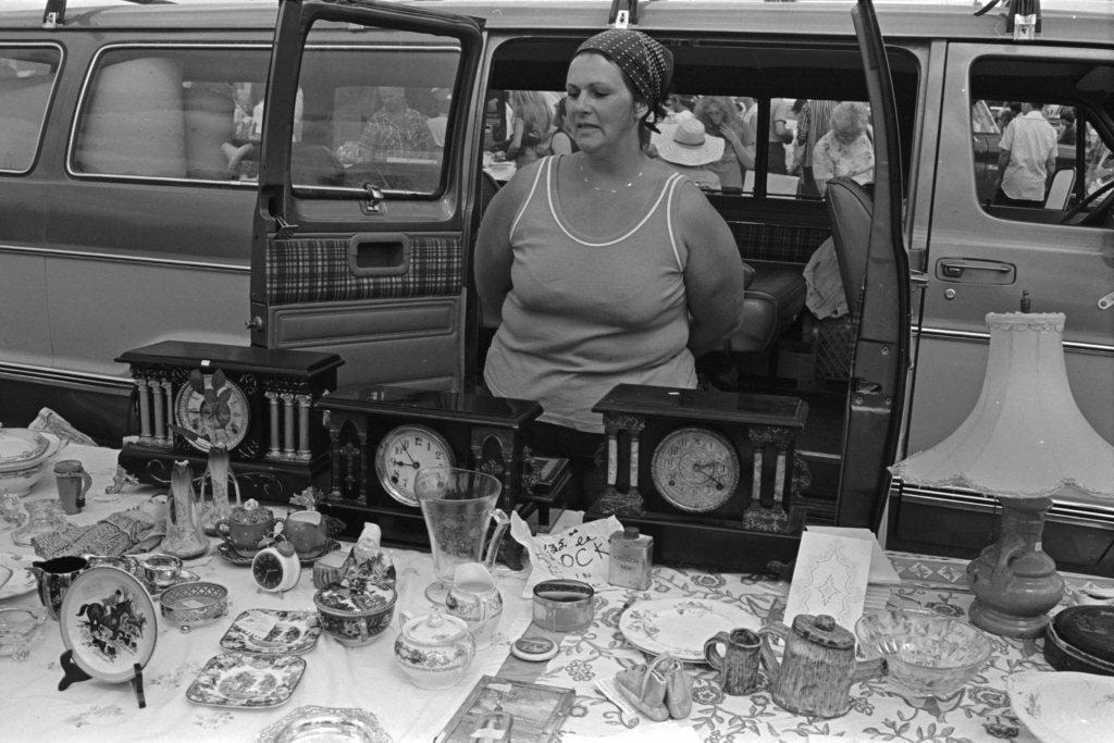
- Photograph of a table of antique clocks and flatware at the Lougheed Drive-in swap meet in the summer of 1978. An unidentified vendor is standing behind the table with her hands behind her back.
- Repository
- City of Burnaby Archives
- Date
- 1978
- Collection/Fonds
- Bill Jeffries fonds
- Physical Description
- 1 photograph : b&w negative ; 35 mm
- Description Level
- Item
- Record No.
- 528-045
- Access Restriction
- No restrictions
- Reproduction Restriction
- No restrictions
- Accession Number
- 2011-01
- Scope and Content
- Photograph of a table of antique clocks and flatware at the Lougheed Drive-in swap meet in the summer of 1978. An unidentified vendor is standing behind the table with her hands behind her back.
- Media Type
- Photograph
- Photographer
- Jeffries, Bill
- Notes
- Title based on contents of item
- Geographic Access
- Lougheed Highway
- Historic Neighbourhood
- Broadview (Historic Neighbourhood)
- Planning Study Area
- West Central Valley Area
Images
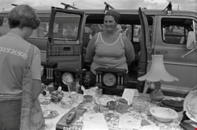
Antique clocks and flatware
https://search.heritageburnaby.ca/link/archivedescription70423
- Repository
- City of Burnaby Archives
- Date
- 1978
- Collection/Fonds
- Bill Jeffries fonds
- Description Level
- Item
- Physical Description
- 1 photograph : b&w negative ; 35 mm
- Scope and Content
- Photograph of a table of antique clocks and flatware at the Lougheed Drive-in swap meet in the summer of 1978. An unidentified vendor is standing behind the table, smiling at a potential customer.
- Repository
- City of Burnaby Archives
- Date
- 1978
- Collection/Fonds
- Bill Jeffries fonds
- Physical Description
- 1 photograph : b&w negative ; 35 mm
- Description Level
- Item
- Record No.
- 528-119
- Access Restriction
- No restrictions
- Reproduction Restriction
- No restrictions
- Accession Number
- 2011-01
- Scope and Content
- Photograph of a table of antique clocks and flatware at the Lougheed Drive-in swap meet in the summer of 1978. An unidentified vendor is standing behind the table, smiling at a potential customer.
- Media Type
- Photograph
- Photographer
- Jeffries, Bill
- Notes
- Title based on contents of item
- Geographic Access
- Lougheed Highway
- Historic Neighbourhood
- Broadview (Historic Neighbourhood)
- Planning Study Area
- West Central Valley Area
Images
