Narrow Results By

Broadview Neighbourhood
https://search.heritageburnaby.ca/link/landmark687
- Repository
- Burnaby Heritage Planning
- Associated Dates
- 1925-1954
- Heritage Value
- Development in the Broadview area slowed during World War Two, but after the war, the area became home to a number of industrial sites. The first major plant to be built here was the Dominion Bridge Company which opened in 1930.
- Historic Neighbourhood
- Broadview (Historic Neighbourhood)
- Planning Study Area
- Cascade-Schou Area
Images


Burnaby General Hospital
https://search.heritageburnaby.ca/link/landmark690
- Repository
- Burnaby Heritage Planning
- Geographic Access
- Kincaid Street
- Associated Dates
- 1952
- Heritage Value
- Burnaby residents had long been asking for a hospital in their municipality so on July 14, 1943, the first meeting of the Burnaby Hospital Fund-raising Committee was held at the Canadian Legion Hall at Royal Oak and Kingsway. In 1947, the group was incorporated as the Burnaby Hospital Society and after extensive lobbying and fundraising, the Burnaby General Hospital opened its doors on October 30, 1952. The site was provided by the Municipality of Burnaby on 17.5 acres of parkland on a small hill in the Cascade Heights area. In its first year, the hospital admitted 5010 patients and delivered 944 babies.
- Historic Neighbourhood
- Broadview (Historic Neighbourhood)
- Planning Study Area
- Cascade-Schou Area
- Street Address
- 3935 Kincaid Street
- Street View URL
- Google Maps Street View
Images


Cascade-Schou Neighbourhood
https://search.heritageburnaby.ca/link/landmark798
- Repository
- Burnaby Heritage Planning
- Associated Dates
- 1955-2008
- Heritage Value
- The Cascade-Schou neighbourhood, sometimes referred to as the Cascade Heights area, includes both the Burnaby General Hospital site, the Discovery Park facilities and is bordered on its eastern boundary by BCIT. Despite these health and science developments, the neighbourhood can still be considered to be a residential community. The housing stock includes single family homes as well as newer multi-family residences that developed throughout the 1980s and 1990s.
- Historic Neighbourhood
- Broadview (Historic Neighbourhood)
- Planning Study Area
- Cascade-Schou Area
Images


West Central Valley Neighbourhood
https://search.heritageburnaby.ca/link/landmark778
- Repository
- Burnaby Heritage Planning
- Associated Dates
- 1955-2008
- Heritage Value
- The West Central Valley Neighbourhood is home to the Bridge Business Park and is a primarily industrial neighbourhood. Similar to the adjacent Dawson-Delta Neighbourhood, West Central Valley offers businesses convenient access to major roads and highways.
- Historic Neighbourhood
- Broadview (Historic Neighbourhood)
- Planning Study Area
- West Central Valley Area
Images

![BCER 1233 at Horne-Payne siding, [1952] thumbnail](/media/hpo/_Data/_BVM_Images/2012/2012_0018_0007_001.jpg?width=280)
BCER 1233 at Horne-Payne siding
https://search.heritageburnaby.ca/link/museumdescription2883
- Repository
- Burnaby Village Museum
- Date
- [1952]
- Collection/Fonds
- Burnaby Village Museum Photograph collection
- Description Level
- Item
- Physical Description
- 1 photograph : b&w ; 9 x 13 cm
- Scope and Content
- Photograph of British Columbia Electric Railway car 1233 at Horne-Payne siding awaiting the passing of the west bound train on the Burnaby Lake line. Gordin Gregg is identified as the motor man at the front.
- Repository
- Burnaby Village Museum
- Collection/Fonds
- Burnaby Village Museum Photograph collection
- Description Level
- Item
- Physical Description
- 1 photograph : b&w ; 9 x 13 cm
- Scope and Content
- Photograph of British Columbia Electric Railway car 1233 at Horne-Payne siding awaiting the passing of the west bound train on the Burnaby Lake line. Gordin Gregg is identified as the motor man at the front.
- Subjects
- Transportation - Electric Railroads
- Accession Code
- BV012.18.7
- Access Restriction
- No restrictions
- Reproduction Restriction
- May be restricted by third party rights
- Date
- [1952]
- Media Type
- Photograph
- Historic Neighbourhood
- Broadview (Historic Neighbourhood)
- Planning Study Area
- Brentwood Area
- Scan Resolution
- 600
- Scan Date
- 13-Mar-2018
- Notes
- Title based on contents of photograph
- Note in blue ink on verso of photograph reads: "On a warm summer afternoon, in 1952, east bound / B.C.E.R. #1233 pulls into passig siding at the / Horne-Payne subbstation to await the passing of the / west bound train on th eBurnaby Lake Line."
- Typewritten note on verso reads: "Gordin Gregg - Motor man"
Images
![BCER 1233 at Horne-Payne siding, [1952] thumbnail](/media/hpo/_Data/_BVM_Images/2012/2012_0018_0007_001.jpg)
![Bud Pope and Bill Stewart on Interurban tram 1224, [1953] (date of original), copied 1985 thumbnail](/media/hpo/_Data/_BVM_Images/1985/1985_0328_0002_001.jpg?width=280)
Bud Pope and Bill Stewart on Interurban tram 1224
https://search.heritageburnaby.ca/link/museumdescription208
- Repository
- Burnaby Village Museum
- Date
- [1953] (date of original), copied 1985
- Collection/Fonds
- Burnaby Village Museum Photograph collection
- Description Level
- Item
- Physical Description
- 1 photograph : b&w ; 17.7 x 12.6 cm print
- Scope and Content
- Photograph of two men, identified as Bud Pope (conductor) and Bill Stewart (motorman), standing on the front of Interurban tram #1224 at Horne-Payne Siding. Faintly visible in the background are transmission towers. According to the accession register and notes in the accession file, the photograph…
- Repository
- Burnaby Village Museum
- Collection/Fonds
- Burnaby Village Museum Photograph collection
- Description Level
- Item
- Physical Description
- 1 photograph : b&w ; 17.7 x 12.6 cm print
- Scope and Content
- Photograph of two men, identified as Bud Pope (conductor) and Bill Stewart (motorman), standing on the front of Interurban tram #1224 at Horne-Payne Siding. Faintly visible in the background are transmission towers. According to the accession register and notes in the accession file, the photograph was taken on the last day of the Burnaby Lake line run.
- Subjects
- Transportation - Electric Railroads
- Accession Code
- BV985.328.2
- Access Restriction
- No restrictions
- Reproduction Restriction
- May be restricted by third party rights
- Date
- [1953] (date of original), copied 1985
- Media Type
- Photograph
- Historic Neighbourhood
- Broadview (Historic Neighbourhood)
- Planning Study Area
- West Central Valley Area
- Scan Resolution
- 600
- Scan Date
- 16-Jan-24
- Scale
- 100
- Notes
- Title based on contents of photograph
- 1 b&w copy negative accompanying
Images
![Bud Pope and Bill Stewart on Interurban tram 1224, [1953] (date of original), copied 1985 thumbnail](/media/hpo/_Data/_BVM_Images/1985/1985_0328_0002_001.jpg)
Dominion Bridge Company Limited - Burnaby Plant
https://search.heritageburnaby.ca/link/museumdescription17538
- Repository
- Burnaby Village Museum
- Date
- 29 Aug. 1957
- Collection/Fonds
- Burnaby Village Museum Map collection
- Description Level
- Item
- Physical Description
- 1 plan : col. lithographic print ; 50.5 x 84 cm
- Scope and Content
- Item consists of a fire insurance plan of the Dominion Bridge Company Burnaby Plant located on the east side of Boundary Road near Lougheed Highway. The plan is in two sheets mounted on a backing board. The buildings are located and colour coded. The plan includes profiles of the buildings. Title o…
- Repository
- Burnaby Village Museum
- Collection/Fonds
- Burnaby Village Museum Map collection
- Description Level
- Item
- Physical Description
- 1 plan : col. lithographic print ; 50.5 x 84 cm
- Material Details
- Scale [1:960]
- Scope and Content
- Item consists of a fire insurance plan of the Dominion Bridge Company Burnaby Plant located on the east side of Boundary Road near Lougheed Highway. The plan is in two sheets mounted on a backing board. The buildings are located and colour coded. The plan includes profiles of the buildings. Title on plan reads "DOMINION BRIDGE COMPANY, LIMITED / "BURNABY PLANT" / Burnaby, B.C.". The site plan was surveyed by C. L. Schwaab Jr.
- History
- Dominion Bridge Company was a major enterprise in Burnaby operating from the 1930 until the mid 1970s. Dominion Bridge constructed steel structures ranging from portions of the Golden Gate and Lions Gate Bridges to holding tanks for pulp mills. Beginning in the mid-1970s, unused areas of the site were used for filming on a temporary basis and in 1987 the site was established as a dedicated studio production facility named Bridge Studios.
- Creator
- Schwabb, C.L. Jr.
- Subjects
- Buildings - Industrial - Factories
- Names
- Dominion Bridge Company
- Responsibility
- Associated Factory Mutual Fire Insurance Cos
- Geographic Access
- Boundary Road
- Street Address
- 2400 Boundary Road
- Accession Code
- BV015.10.1
- Access Restriction
- Restricted access
- Reproduction Restriction
- May be restricted by third party rights
- Date
- 29 Aug. 1957
- Media Type
- Cartographic Material
- Historic Neighbourhood
- Broadview (Historic Neighbourhood)
- Planning Study Area
- West Central Valley Area
- Scan Resolution
- 400
- Scan Date
- 2021-11-28
- Notes
- Title based on contents of plan
- Scale on plan reads "1 inch = 80 ft / By V. Pitkin"
- Identfication information in bottom right corner of plan reads: "FACTORY MUTUAL ENGINEERING DIVISION / Associated Factory Mutual Fire Insurance Cos. / Norwood, Mass. / SERIAl 47330 / Replacing 35238 / INDEX 3994"
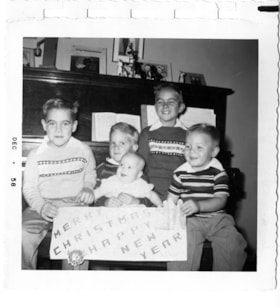
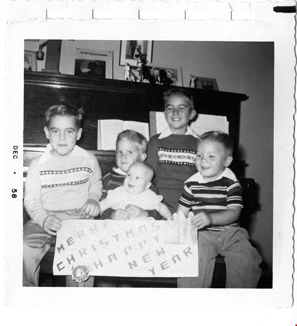
Sanders children at Christmas
https://search.heritageburnaby.ca/link/museumdescription9914
- Repository
- Burnaby Village Museum
- Date
- Dec. 1958
- Collection/Fonds
- Gerald F. Sanders and Alice Sparman Sanders fonds
- Description Level
- Item
- Physical Description
- 1 photograph : b&w ; 8.9 cm x 8.9 cm
- Scope and Content
- Photograph of Sanders children from left to right: Kerry Sanders, David Sanders, Ruth Sanders (being held on lap), Dennis Sanders (standing at back), and Kris Sanders. The children hold a sign which reads "Merry Christmas Happy New Year"
- Repository
- Burnaby Village Museum
- Collection/Fonds
- Gerald F. Sanders and Alice Sparman Sanders fonds
- Description Level
- Item
- Physical Description
- 1 photograph : b&w ; 8.9 cm x 8.9 cm
- Material Details
- photograph printed on photograph paper with scalloped edge and top edge punched with holes for binding
- Scope and Content
- Photograph of Sanders children from left to right: Kerry Sanders, David Sanders, Ruth Sanders (being held on lap), Dennis Sanders (standing at back), and Kris Sanders. The children hold a sign which reads "Merry Christmas Happy New Year"
- Subjects
- Holidays - Christmas
- Accession Code
- BV018.34.39
- Access Restriction
- No restrictions
- Reproduction Restriction
- No known restrictions
- Date
- Dec. 1958
- Media Type
- Photograph
- Historic Neighbourhood
- Broadview (Historic Neighbourhood)
- Planning Study Area
- Cascade-Schou Area
- Scan Resolution
- 600
- Scan Date
- 2022-07-12
- Notes
- Title based on contents of photograph
Images
![Tom White, Dave Maw, and Bert Vicars, [1956] thumbnail](/media/hpo/_Data/_BVM_Images/2000/200300460012.jpg?width=280)
Tom White, Dave Maw, and Bert Vicars
https://search.heritageburnaby.ca/link/museumdescription1745
- Repository
- Burnaby Village Museum
- Date
- [1956]
- Collection/Fonds
- Burnaby Village Museum Photograph collection
- Description Level
- Item
- Physical Description
- 1 photograph : b&w ; 7.5 x 7.5 cm
- Scope and Content
- Photograph of Tom White, Dave Maw, and Bert Vicars, three Dominion Bridge Company staff, standing in front of a car that has been parked in front of Dominion Bridge Company's Burnaby Plant.
- Repository
- Burnaby Village Museum
- Collection/Fonds
- Burnaby Village Museum Photograph collection
- Description Level
- Item
- Physical Description
- 1 photograph : b&w ; 7.5 x 7.5 cm
- Material Details
- Photograph has scalloped edges
- Scope and Content
- Photograph of Tom White, Dave Maw, and Bert Vicars, three Dominion Bridge Company staff, standing in front of a car that has been parked in front of Dominion Bridge Company's Burnaby Plant.
- Subjects
- Industries - Construction
- Geographic Access
- Henning Drive
- Street Address
- 3880 Henning Drive
- Accession Code
- BV003.46.12
- Access Restriction
- No restrictions
- Reproduction Restriction
- No known restrictions
- Date
- [1956]
- Media Type
- Photograph
- Historic Neighbourhood
- Broadview (Historic Neighbourhood)
- Planning Study Area
- West Central Valley Area
- Scan Resolution
- 600
- Scan Date
- 09-Jun-09
- Scale
- 100
- Notes
- Title based on contents of photograph
- Note in black ink on verso of photograph reads: "Tom White / Dave Maw / Bert Vicars"
Images
![Tom White, Dave Maw, and Bert Vicars, [1956] thumbnail](/media/hpo/_Data/_BVM_Images/2000/200300460012.jpg)