Narrow Results By
Subject
- Accidents - Train Accidents
- Advertising Medium 1
- Advertising Medium - Signs and Signboards
- Aerial Photographs 2
- Arts 2
- Buildings - Commercial
- Buildings - Commercial - Banks 1
- Buildings - Commercial - Hotels and Motels 1
- Buildings - Commercial - Malls 23
- Buildings - Commercial - Offices 1
- Buildings - Commercial - Restaurants 1
- Buildings - Commercial - Service Stations 1
![Ancient Willow Bed & Breakfast sign, [2000] thumbnail](/media/hpo/_Data/_Archives_Images/_Unrestricted/535/535-2137.jpg?width=280)
Ancient Willow Bed & Breakfast sign
https://search.heritageburnaby.ca/link/archivedescription96513
- Repository
- City of Burnaby Archives
- Date
- [2000]
- Collection/Fonds
- Burnaby NewsLeader photograph collection
- Description Level
- Item
- Physical Description
- 1 photograph (tiff) : col.
- Scope and Content
- Photograph of Leah-Anne Arbers posing in front of her bed and breakfast, Ancient Willow, with a sign that was broken by vandals. Arbers' cousin Olga Shevchenko stands behind her, holding part of the broken sign, which reads: "BED."
- Repository
- City of Burnaby Archives
- Date
- [2000]
- Collection/Fonds
- Burnaby NewsLeader photograph collection
- Physical Description
- 1 photograph (tiff) : col.
- Description Level
- Item
- Record No.
- 535-2137
- Access Restriction
- No restrictions
- Reproduction Restriction
- No restrictions
- Accession Number
- 2018-12
- Scope and Content
- Photograph of Leah-Anne Arbers posing in front of her bed and breakfast, Ancient Willow, with a sign that was broken by vandals. Arbers' cousin Olga Shevchenko stands behind her, holding part of the broken sign, which reads: "BED."
- Subjects
- Buildings - Commercial - Hotels and Motels
- Advertising Medium - Signs and Signboards
- Crimes
- Media Type
- Photograph
- Photographer
- Bartel, Mario
- Notes
- Title based on caption
- Collected by editorial for use in an April 2000 issue of the Burnaby NewsLeader
- Caption from metadata: "Leah-Anne Arbers, and her cousin, Olga Shevchenko, who helps her run her Parker St. bed and breakfast, with pieces of the sign destroyed by teenage vandals."
- Geographic Access
- Parker Street
- Planning Study Area
- Willingdon Heights Area
- Brentwood Area
Images
![Ancient Willow Bed & Breakfast sign, [2000] thumbnail](/media/hpo/_Data/_Archives_Images/_Unrestricted/535/535-2137.jpg)
![Clearing for shopping centre, [1958] thumbnail](/media/hpo/_Data/_Archives_Images/_Unrestricted/559/564-002.jpg?width=280)
Clearing for shopping centre
https://search.heritageburnaby.ca/link/archivedescription85130
- Repository
- City of Burnaby Archives
- Date
- [1958]
- Collection/Fonds
- Ben Bradley collection
- Description Level
- Item
- Physical Description
- 1 photograph : b&w ; 8.2 x 11.5 cm
- Scope and Content
- Photograph of land being cleared for the Brentwood Mall with Burnaby mountain in the background.
- Repository
- City of Burnaby Archives
- Date
- [1958]
- Collection/Fonds
- Ben Bradley collection
- Physical Description
- 1 photograph : b&w ; 8.2 x 11.5 cm
- Description Level
- Item
- Record No.
- 564-002
- Access Restriction
- No restrictions
- Reproduction Restriction
- Reproduce for fair dealing purposes only
- Accession Number
- 2013-30
- Scope and Content
- Photograph of land being cleared for the Brentwood Mall with Burnaby mountain in the background.
- Subjects
- Buildings - Commercial
- Land Clearing
- Media Type
- Photograph
- Notes
- Transcribed title
- Note on verso reads: "Clearing for shopping centre"
- Street Address
- 4567 Lougheed Highway
- Planning Study Area
- Brentwood Area
Images
![Clearing for shopping centre, [1958] thumbnail](/media/hpo/_Data/_Archives_Images/_Unrestricted/559/564-002.jpg)
![Clearing for shopping centre, [1958] thumbnail](/media/hpo/_Data/_Archives_Images/_Unrestricted/559/564-003.jpg?width=280)
Clearing for shopping centre
https://search.heritageburnaby.ca/link/archivedescription85131
- Repository
- City of Burnaby Archives
- Date
- [1958]
- Collection/Fonds
- Ben Bradley collection
- Description Level
- Item
- Physical Description
- 1 photograph : b&w ; 8.2 x 11.5 cm
- Scope and Content
- Photograph with tree stumps, rocks and dirt of land being cleared for the Brentwood Mall.
- Repository
- City of Burnaby Archives
- Date
- [1958]
- Collection/Fonds
- Ben Bradley collection
- Physical Description
- 1 photograph : b&w ; 8.2 x 11.5 cm
- Description Level
- Item
- Record No.
- 564-003
- Access Restriction
- No restrictions
- Reproduction Restriction
- Reproduce for fair dealing purposes only
- Accession Number
- 2013-30
- Scope and Content
- Photograph with tree stumps, rocks and dirt of land being cleared for the Brentwood Mall.
- Subjects
- Buildings - Commercial
- Land Clearing
- Media Type
- Photograph
- Notes
- Title based on contents of photograph
- Street Address
- 4567 Lougheed Highway
- Planning Study Area
- Brentwood Area
Images
![Clearing for shopping centre, [1958] thumbnail](/media/hpo/_Data/_Archives_Images/_Unrestricted/559/564-003.jpg)
![Clearing for shopping centre, [1958] thumbnail](/media/hpo/_Data/_Archives_Images/_Unrestricted/559/564-005.jpg?width=280)
Clearing for shopping centre
https://search.heritageburnaby.ca/link/archivedescription85133
- Repository
- City of Burnaby Archives
- Date
- [1958]
- Collection/Fonds
- Ben Bradley collection
- Description Level
- Item
- Physical Description
- 1 photograph : b&w ; 8.2 x 11.5 cm
- Scope and Content
- Photograph with tree stumps, rocks and dirt of land being cleared for the Brentwood Mall.
- Repository
- City of Burnaby Archives
- Date
- [1958]
- Collection/Fonds
- Ben Bradley collection
- Physical Description
- 1 photograph : b&w ; 8.2 x 11.5 cm
- Description Level
- Item
- Record No.
- 564-005
- Access Restriction
- No restrictions
- Reproduction Restriction
- Reproduce for fair dealing purposes only
- Accession Number
- 2013-30
- Scope and Content
- Photograph with tree stumps, rocks and dirt of land being cleared for the Brentwood Mall.
- Subjects
- Buildings - Commercial
- Land Clearing
- Media Type
- Photograph
- Notes
- Transcribed title
- Note on verso reads: "Clearing for shopping centre"
- Street Address
- 4567 Lougheed Highway
- Planning Study Area
- Brentwood Area
Images
![Clearing for shopping centre, [1958] thumbnail](/media/hpo/_Data/_Archives_Images/_Unrestricted/559/564-005.jpg)
![Clearing for the shopping centre, [1958] thumbnail](/media/hpo/_Data/_Archives_Images/_Unrestricted/559/564-001.jpg?width=280)
Clearing for the shopping centre
https://search.heritageburnaby.ca/link/archivedescription85125
- Repository
- City of Burnaby Archives
- Date
- [1958]
- Collection/Fonds
- Ben Bradley collection
- Description Level
- Item
- Physical Description
- 1 photograph : b&w ; 8.2 x 11.5 cm
- Scope and Content
- Photograph of children climbing on a large tree stump on land being cleared for the Brentwood Mall.
- Repository
- City of Burnaby Archives
- Date
- [1958]
- Collection/Fonds
- Ben Bradley collection
- Physical Description
- 1 photograph : b&w ; 8.2 x 11.5 cm
- Description Level
- Item
- Record No.
- 564-001
- Access Restriction
- No restrictions
- Reproduction Restriction
- Reproduce for fair dealing purposes only
- Accession Number
- 2013-30
- Scope and Content
- Photograph of children climbing on a large tree stump on land being cleared for the Brentwood Mall.
- Subjects
- Buildings - Commercial
- Land Clearing
- Media Type
- Photograph
- Notes
- Transcribed title
- Note on verso reads: "Clearing for shopping centre"
- Street Address
- 4567 Lougheed Highway
- Planning Study Area
- Brentwood Area
Images
![Clearing for the shopping centre, [1958] thumbnail](/media/hpo/_Data/_Archives_Images/_Unrestricted/559/564-001.jpg)
![Commercial realtor Scott Brown, [2002] thumbnail](/media/hpo/_Data/_Archives_Images/_Unrestricted/535/535-1970.jpg?width=280)
Commercial realtor Scott Brown
https://search.heritageburnaby.ca/link/archivedescription96287
- Repository
- City of Burnaby Archives
- Date
- [2002]
- Collection/Fonds
- Burnaby NewsLeader photograph collection
- Description Level
- Item
- Physical Description
- 1 photograph (tiff) : col.
- Scope and Content
- Photograph of commercial real estate broker Scott Brown. Brown is standing in front of the Madison Centre on Lougheed Highway with his arms wide open. A sign in the window of the office tower reads: "For Lease."
- Repository
- City of Burnaby Archives
- Date
- [2002]
- Collection/Fonds
- Burnaby NewsLeader photograph collection
- Physical Description
- 1 photograph (tiff) : col.
- Description Level
- Item
- Record No.
- 535-1970
- Access Restriction
- No restrictions
- Reproduction Restriction
- No restrictions
- Accession Number
- 2018-12
- Scope and Content
- Photograph of commercial real estate broker Scott Brown. Brown is standing in front of the Madison Centre on Lougheed Highway with his arms wide open. A sign in the window of the office tower reads: "For Lease."
- Media Type
- Photograph
- Photographer
- Bartel, Mario
- Notes
- Title based on caption
- Collected by editorial for use in a February 2002 issue of the Burnaby NewsLeader
- Caption from metadata: "Scott Brown, a commercial real estate broker, says things are looking up for businesses looking for office space in Burnaby, as new space in buildings like the Madison Centre have increased the vacancy rates."
- Geographic Access
- Lougheed Highway
- Planning Study Area
- Brentwood Area
Images
![Commercial realtor Scott Brown, [2002] thumbnail](/media/hpo/_Data/_Archives_Images/_Unrestricted/535/535-1970.jpg)
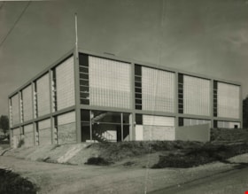
Glenburn Telephone Exchange
https://search.heritageburnaby.ca/link/archivedescription34706
- Repository
- City of Burnaby Archives
- Date
- 1959
- Collection/Fonds
- Burnaby Historical Society fonds
- Description Level
- Item
- Physical Description
- 1 photograph : b&w ; 20.2 x 25.7 cm
- Scope and Content
- Photograph of the exterior of the Glenburn Telephone Exchange at Delta Avenue and Parker Street. A typed description on the back of the photograph reads, "Glenburn Automatic Exchange at Delta and Parker streets. To be cutover in March, 1959. / B.C. Telephone Company."
- Repository
- City of Burnaby Archives
- Date
- 1959
- Collection/Fonds
- Burnaby Historical Society fonds
- Subseries
- Photographs subseries
- Physical Description
- 1 photograph : b&w ; 20.2 x 25.7 cm
- Description Level
- Item
- Record No.
- 111-001
- Access Restriction
- No restrictions
- Reproduction Restriction
- Reproduce for fair dealing purposes only
- Accession Number
- BHS2007-04
- Scope and Content
- Photograph of the exterior of the Glenburn Telephone Exchange at Delta Avenue and Parker Street. A typed description on the back of the photograph reads, "Glenburn Automatic Exchange at Delta and Parker streets. To be cutover in March, 1959. / B.C. Telephone Company."
- Subjects
- Buildings - Commercial
- Media Type
- Photograph
- Photographer
- Graphic Industries Limited
- Notes
- Title based on contents of photograph
- Caption at bottom of photograph reads, "British Columbia Telephone Company"
- Stamp on back of photograph reads, "Photo by Graphic Industries Ltd. / File No. 3841-2 / Vancouver, Canada Mutual 1-4174"
- Geographic Access
- Delta Avenue
- Parker Street
- Planning Study Area
- Brentwood Area
Images
![Start of Brentwood Shopping Centre 1958, [1958] thumbnail](/media/hpo/_Data/_Archives_Images/_Unrestricted/559/564-004.jpg?width=280)
Start of Brentwood Shopping Centre 1958
https://search.heritageburnaby.ca/link/archivedescription85132
- Repository
- City of Burnaby Archives
- Date
- [1958]
- Collection/Fonds
- Ben Bradley collection
- Description Level
- Item
- Physical Description
- 1 photograph : b&w ; 8.2 x 11.5 cm
- Scope and Content
- Photograph with tree stumps, rocks and dirt of land being cleared for the Brentwood Mall.
- Repository
- City of Burnaby Archives
- Date
- [1958]
- Collection/Fonds
- Ben Bradley collection
- Physical Description
- 1 photograph : b&w ; 8.2 x 11.5 cm
- Description Level
- Item
- Record No.
- 564-004
- Access Restriction
- No restrictions
- Reproduction Restriction
- Reproduce for fair dealing purposes only
- Accession Number
- 2013-30
- Scope and Content
- Photograph with tree stumps, rocks and dirt of land being cleared for the Brentwood Mall.
- Subjects
- Buildings - Commercial
- Land Clearing
- Media Type
- Photograph
- Notes
- Transcribed title
- Note on verso reads: "Start of Brentwood Shopping Centre 1958"
- Street Address
- 4567 Lougheed Highway
- Planning Study Area
- Brentwood Area
Images
![Start of Brentwood Shopping Centre 1958, [1958] thumbnail](/media/hpo/_Data/_Archives_Images/_Unrestricted/559/564-004.jpg)
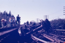
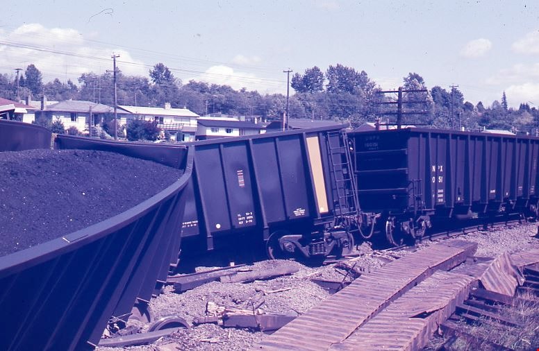
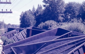
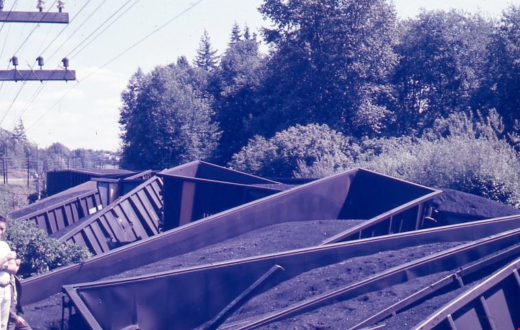
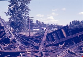
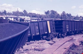
Train wreck at Kensington Avenue
https://search.heritageburnaby.ca/link/museumdescription4306
- Repository
- Burnaby Village Museum
- Date
- 16 Aug. 1970
- Collection/Fonds
- Burnaby Village Museum Photograph collection
- Description Level
- Item
- Physical Description
- 1 photograph : col. ; 35 mm
- Scope and Content
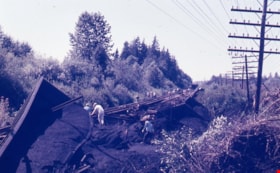
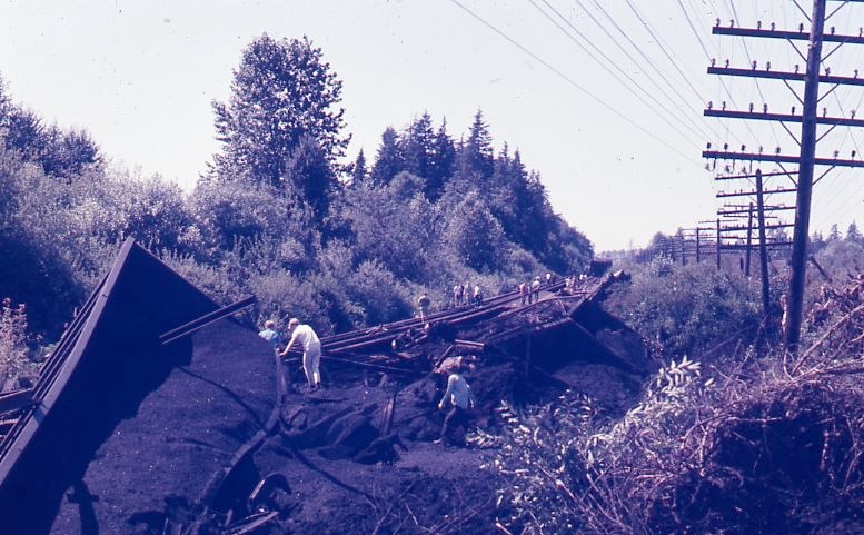
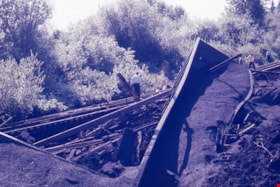
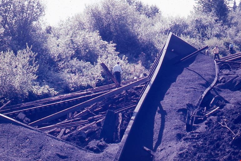
- Photograph of a train wreck at Kensington Avenue and the Lougheed Highway on Aug 16, 1970. The Farmer family was living at Buchanan Street and Holdom Avenue and they heard the train wreck when it happened.
- Repository
- Burnaby Village Museum
- Collection/Fonds
- Burnaby Village Museum Photograph collection
- Description Level
- Item
- Physical Description
- 1 photograph : col. ; 35 mm
- Material Details
- The slide was processed in Canachrome by Mortifee Munshaw.
- Handwritten text in ink on slide frame reads: "Train Wreck / Aug 16 /70".
- Scope and Content
- Photograph of a train wreck at Kensington Avenue and the Lougheed Highway on Aug 16, 1970. The Farmer family was living at Buchanan Street and Holdom Avenue and they heard the train wreck when it happened.
- Names
- Farmer, Joanne
- Geographic Access
- Kensington Avenue
- Lougheed Highway
- Accession Code
- BV017.42.1
- Access Restriction
- No restrictions
- Reproduction Restriction
- No known restrictions
- Date
- 16 Aug. 1970
- Media Type
- Photograph
- Planning Study Area
- Brentwood Area
- Scan Resolution
- 600
- Scan Date
- 05-Jun-2018
- Notes
- Title based on contents of photograph
Images

Train wreck at Kensington Avenue
https://search.heritageburnaby.ca/link/museumdescription4307
- Repository
- Burnaby Village Museum
- Date
- 16 Aug. 1970
- Collection/Fonds
- Burnaby Village Museum Photograph collection
- Description Level
- Item
- Physical Description
- 1 photograph : col. ; 35 mm
- Scope and Content
- Photograph of a train wreck at Kensington Avenue and the Lougheed Highway on Aug 16, 1970. The Farmer family was living at Buchanan Street and Holdom Avenue and they heard the train wreck when it happened.
- Repository
- Burnaby Village Museum
- Collection/Fonds
- Burnaby Village Museum Photograph collection
- Description Level
- Item
- Physical Description
- 1 photograph : col. ; 35 mm
- Material Details
- The slide was processed in Canachrome by Mortifee Munshaw.
- Handwritten text in ink on slide frame reads: "Train Wreck / Aug 16 /70".
- Scope and Content
- Photograph of a train wreck at Kensington Avenue and the Lougheed Highway on Aug 16, 1970. The Farmer family was living at Buchanan Street and Holdom Avenue and they heard the train wreck when it happened.
- Names
- Farmer, Joanne
- Geographic Access
- Kensington Avenue
- Lougheed Highway
- Accession Code
- BV017.42.2
- Access Restriction
- No restrictions
- Reproduction Restriction
- No known restrictions
- Date
- 16 Aug. 1970
- Media Type
- Photograph
- Planning Study Area
- Brentwood Area
- Scan Resolution
- 600
- Scan Date
- 05-Jun-2018
- Notes
- Title based on contents of photograph
Images
Train wreck at Kensington Avenue
https://search.heritageburnaby.ca/link/museumdescription4308
- Repository
- Burnaby Village Museum
- Date
- 16 Aug. 1970
- Collection/Fonds
- Burnaby Village Museum Photograph collection
- Description Level
- Item
- Physical Description
- 1 photograph : col. ; 35 mm
- Scope and Content
- Photograph of a train wreck at Kensington Avenue and the Lougheed Highway on Aug 16, 1970. The Farmer family was living at Buchanan Street and Holdom Avenue and they heard the train wreck when it happened.
- Repository
- Burnaby Village Museum
- Collection/Fonds
- Burnaby Village Museum Photograph collection
- Description Level
- Item
- Physical Description
- 1 photograph : col. ; 35 mm
- Material Details
- The slide was processed in Canachrome by Mortifee Munshaw.
- Handwritten text in ink on slide frame reads: "Train Wreck / Aug 16 /70 / Lougheed Hiway".
- Scope and Content
- Photograph of a train wreck at Kensington Avenue and the Lougheed Highway on Aug 16, 1970. The Farmer family was living at Buchanan Street and Holdom Avenue and they heard the train wreck when it happened.
- Names
- Farmer, Joanne
- Geographic Access
- Kensington Avenue
- Lougheed Highway
- Accession Code
- BV017.42.3
- Access Restriction
- No restrictions
- Reproduction Restriction
- No known restrictions
- Date
- 16 Aug. 1970
- Media Type
- Photograph
- Planning Study Area
- Brentwood Area
- Scan Resolution
- 600
- Scan Date
- 05-Jun-2018
- Notes
- Title based on contents of photograph
Images
Train wreck at Kensington Avenue
https://search.heritageburnaby.ca/link/museumdescription4309
- Repository
- Burnaby Village Museum
- Date
- 16 Aug. 1970
- Collection/Fonds
- Burnaby Village Museum Photograph collection
- Description Level
- Item
- Physical Description
- 1 photograph : col. ; 35 mm
- Scope and Content
- Photograph of a train wreck at Kensington Avenue and the Lougheed Highway on Aug 16, 1970. The Farmer family was living at Buchanan Street and Holdom Avenue and they heard the train wreck when it happened.
- Repository
- Burnaby Village Museum
- Collection/Fonds
- Burnaby Village Museum Photograph collection
- Description Level
- Item
- Physical Description
- 1 photograph : col. ; 35 mm
- Material Details
- The slide was processed in Canachrome by Mortifee Munshaw.
- Handwritten text in ink on slide frame reads: "Train Wreck / Aug 16 /70".
- Scope and Content
- Photograph of a train wreck at Kensington Avenue and the Lougheed Highway on Aug 16, 1970. The Farmer family was living at Buchanan Street and Holdom Avenue and they heard the train wreck when it happened.
- Names
- Farmer, Joanne
- Geographic Access
- Kensington Avenue
- Lougheed Highway
- Accession Code
- BV017.42.4
- Access Restriction
- No restrictions
- Reproduction Restriction
- No known restrictions
- Date
- 16 Aug. 1970
- Media Type
- Photograph
- Planning Study Area
- Brentwood Area
- Scan Resolution
- 600
- Scan Date
- 05-Jun-2018
- Notes
- Title based on contents of photograph
Images
Train wreck at Kensington Avenue
https://search.heritageburnaby.ca/link/museumdescription4310
- Repository
- Burnaby Village Museum
- Date
- 16 Aug. 1970
- Collection/Fonds
- Burnaby Village Museum Photograph collection
- Description Level
- Item
- Physical Description
- 1 photograph : col. ; 35 mm
- Scope and Content
- Photograph of a train wreck at Kensington Avenue and the Lougheed Highway on Aug 16, 1970. The Farmer family was living at Buchanan Street and Holdom Avenue and they heard the train wreck when it happened.
- Repository
- Burnaby Village Museum
- Collection/Fonds
- Burnaby Village Museum Photograph collection
- Description Level
- Item
- Physical Description
- 1 photograph : col. ; 35 mm
- Material Details
- The slide was processed in Canachrome by Mortifee Munshaw.
- Handwritten text in ink on slide frame reads: "Train Wreck / Aug 16 /70".
- Scope and Content
- Photograph of a train wreck at Kensington Avenue and the Lougheed Highway on Aug 16, 1970. The Farmer family was living at Buchanan Street and Holdom Avenue and they heard the train wreck when it happened.
- Names
- Farmer, Joanne
- Geographic Access
- Kensington Avenue
- Lougheed Highway
- Accession Code
- BV017.42.5
- Access Restriction
- No restrictions
- Reproduction Restriction
- No known restrictions
- Date
- 16 Aug. 1970
- Media Type
- Photograph
- Planning Study Area
- Brentwood Area
- Scan Resolution
- 600
- Scan Date
- 05-Jun-2018
- Notes
- Title based on contents of photograph
Images

Train wreck at Kensington Avenue
https://search.heritageburnaby.ca/link/museumdescription4311
- Repository
- Burnaby Village Museum
- Date
- 16 Aug. 1970
- Collection/Fonds
- Burnaby Village Museum Photograph collection
- Description Level
- Item
- Physical Description
- 1 photograph : col. ; 35 mm
- Scope and Content
- Photograph of a train wreck at Kensington Avenue and the Lougheed Highway on Aug 16, 1970. The Farmer family was living at Buchanan Street and Holdom Avenue and they heard the train wreck when it happened.
- Repository
- Burnaby Village Museum
- Collection/Fonds
- Burnaby Village Museum Photograph collection
- Description Level
- Item
- Physical Description
- 1 photograph : col. ; 35 mm
- Material Details
- The slide was processed in Canachrome by Mortifee Munshaw.
- Handwritten text in ink on slide frame reads: "Train Wreck / Aug 16 /70".
- Scope and Content
- Photograph of a train wreck at Kensington Avenue and the Lougheed Highway on Aug 16, 1970. The Farmer family was living at Buchanan Street and Holdom Avenue and they heard the train wreck when it happened.
- Names
- Farmer, Joanne
- Geographic Access
- Kensington Avenue
- Lougheed Highway
- Accession Code
- BV017.42.6
- Access Restriction
- No restrictions
- Reproduction Restriction
- No known restrictions
- Date
- 16 Aug. 1970
- Media Type
- Photograph
- Planning Study Area
- Brentwood Area
- Scan Resolution
- 600
- Scan Date
- 05-Jun-2018
- Notes
- Title based on contents of photograph
Images