Narrow Results By
![Inter-party meeting at U.B.C., [194-?] thumbnail](/media/hpo/_Data/_BVM_Images/2013/2013_0012_0063_001.jpg?width=280)
Inter-party meeting at U.B.C.
https://search.heritageburnaby.ca/link/museumdescription3706
- Repository
- Burnaby Village Museum
- Date
- [194-?]
- Collection/Fonds
- Harold Edward Winch collection
- Description Level
- Item
- Physical Description
- 1 photograph : b&w ; 25.6 x 20.9 cm
- Scope and Content
- Item is a photograph of Harold Winch speaking at an inter-party meeting at the University of British Columbia (UBC), Vancouver.
- Repository
- Burnaby Village Museum
- Collection/Fonds
- Harold Edward Winch collection
- Description Level
- Item
- Physical Description
- 1 photograph : b&w ; 25.6 x 20.9 cm
- Scope and Content
- Item is a photograph of Harold Winch speaking at an inter-party meeting at the University of British Columbia (UBC), Vancouver.
- Names
- Winch, Harold Edward
- Geographic Access
- Vancouver
- Accession Code
- BV013.12.63
- Date
- [194-?]
- Media Type
- Photograph
- Notes
- Title based on contents of photograph
- Photograph is a part of original scrapbook Item BV013.12.11
Images
![Inter-party meeting at U.B.C., [194-?] thumbnail](/media/hpo/_Data/_BVM_Images/2013/2013_0012_0063_001.jpg)

Bird's Eye View of the Burnaby Lake Area
https://search.heritageburnaby.ca/link/museumdescription15144
- Repository
- Burnaby Village Museum
- Date
- 1977
- Collection/Fonds
- Century Park Museum Association fonds
- Description Level
- Item
- Physical Description
- 1 map : b&w print on paper ; 43 x 63.5 cm
- Scope and Content
- Item consists of a map titled "Birds Eye View of the Burnaby Lake Area Circa 1910". The overview of the Burnaby Lake area was compiled and drawn at Heritage Village by curator John Adams and artist, Carol Swan. The map identifies the Burnaby Lake inter-urban tram line; roads including: Sperling Ave…
- Repository
- Burnaby Village Museum
- Collection/Fonds
- Century Park Museum Association fonds
- Description Level
- Item
- Physical Description
- 1 map : b&w print on paper ; 43 x 63.5 cm
- Material Details
- Scale indeterminable
- Scope and Content
- Item consists of a map titled "Birds Eye View of the Burnaby Lake Area Circa 1910". The overview of the Burnaby Lake area was compiled and drawn at Heritage Village by curator John Adams and artist, Carol Swan. The map identifies the Burnaby Lake inter-urban tram line; roads including: Sperling Avenue (Pole Line Road); Gilpin Avenue; Douglas Road; trail to Vancouver Westminster Road (Kingsway); Buckingham Avenue; Haszard Street; various farms and residences including: Charles Sprott "Norland"; H.T. Ceperley "Fairacres"; Claude Hill's "Brookfield farm" and "Broadview"; F.J. Hart's "Avalon"; Miss Woodward's former and new home, school and post office; Councillor Edgar's hunting cabin; Edgar Sprott's "Mayfield farm" and "Mayfield Lodge"; F.J. Peers "Greyfriars"; Arthur de Windt Haszard; Bernard Hill's boathouse as well as other landmarks including: Doran's Mill; tram stations; Burnaby Lake Store; logging camps; wood cutter's shacks; ice houses; cranberry bog; Still Creek; Deer Lake; Burnaby Lake; Deer Lake Creek; Provincial Government Reserve Proposed Hospital (later Oakalla Prison).
- Creator
- Adams, John
- Swan, Carol
- Names
- Hill, Arthur Claude
- Sprott, Charles Frederick
- Sprott, Louis "Edgar"
- Hart, Frederick John, 1884-1945
- Ceperley, H.T.
- Woodward, Maude
- Woodward, Harriet
- Peers, Francis J.
- Haszard, Arthur de Windt
- Hill, Bernard R.
- Geographic Access
- Deer Lake Avenue
- Sperling Avenue
- Haszard Street
- Buckingham Avenue
- Accession Code
- BV021.1.3
- Access Restriction
- No restrictions
- Reproduction Restriction
- No known restrictions
- Date
- 1977
- Media Type
- Cartographic Material
- Historic Neighbourhood
- Burnaby Lake (Historic Neighbourhood)
- Planning Study Area
- Burnaby Lake Area
- Related Material
- See also: Life with the Moores of Hart House : pioneer days on Burnaby's Deer Lake
- Scan Resolution
- 600
- Scan Date
- 2021-11-12
- Scale
- 100
- Notes
- Transcribed title
- Compiled by John Adams; illustration by Carol Swan
- The map depicts the Burnaby Lake Tram Line as being double tracked, whereas in reality it was single tracked.
- Map is part of the book "Life with the Moores of Hart House : pioneer days on Burnaby's Deer Lake https://search.heritageburnaby.ca/permalink/museumlibrary6314-102
Images


Bird's Eye View of the Burnaby Lake Area
https://search.heritageburnaby.ca/link/museumdescription17543
- Repository
- Burnaby Village Museum
- Date
- 1977
- Collection/Fonds
- Century Park Museum Association fonds
- Description Level
- Item
- Physical Description
- 1 map : b&w print with watercolour ; 43 x 63.5 cm
- Scope and Content
- Item consists of a map titled "Birds Eye View of the Burnaby Lake Area Circa 1910". The overview of the Burnaby Lake area was compiled and drawn at Heritage Village by curator John Adams and artist, Carol Swan. The map identifies the Burnaby Lake inter-urban tram line; roads including: Sperling Ave…
- Repository
- Burnaby Village Museum
- Collection/Fonds
- Century Park Museum Association fonds
- Description Level
- Item
- Physical Description
- 1 map : b&w print with watercolour ; 43 x 63.5 cm
- Material Details
- Scale indeterminable
- Scope and Content
- Item consists of a map titled "Birds Eye View of the Burnaby Lake Area Circa 1910". The overview of the Burnaby Lake area was compiled and drawn at Heritage Village by curator John Adams and artist, Carol Swan. The map identifies the Burnaby Lake inter-urban tram line; roads including: Sperling Avenue (Pole Line Road); Gilpin Avenue; Douglas Road; trail to Vancouver Westminster Road (Kingsway); Buckingham Avenue; Haszard Street; various farms and residences including: Charles Sprott "Norland"; H.T. Ceperley "Fairacres"; Claude Hill's "Brookfield farm" and "Broadview"; F.J. Hart's "Avalon"; Miss Woodward's former and new home, school and post office; Councillor Edgar's hunting cabin; Edgar Sprott's "Mayfield farm" and "Mayfield Lodge"; F.J. Peers "Greyfriars"; Arthur de Windt Haszard; Bernard Hill's boathouse as well as other landmarks including: Doran's Mill; tram stations; Burnaby Lake Store; logging camps; wood cutter's shacks; ice houses; cranberry bog; Still Creek; Deer Lake; Burnaby Lake; Deer Lake Creek; Provincial Government Reserve Proposed Hospital (later Oakalla Prison).
- Creator
- Adams, John
- Swan, Carol
- Names
- Hill, Arthur Claude
- Sprott, Charles Frederick
- Sprott, Louis "Edgar"
- Hart, Frederick John, 1884-1945
- Ceperley, H.T.
- Woodward, Maude
- Woodward, Harriet
- Peers, Francis J.
- Haszard, Arthur de Windt
- Hill, Bernard R.
- Geographic Access
- Deer Lake Avenue
- Sperling Avenue
- Haszard Street
- Buckingham Avenue
- Accession Code
- BV021.1.4
- Access Restriction
- No restrictions
- Reproduction Restriction
- No known restrictions
- Date
- 1977
- Media Type
- Cartographic Material
- Historic Neighbourhood
- Burnaby Lake (Historic Neighbourhood)
- Planning Study Area
- Burnaby Lake Area
- Related Material
- See also: Life with the Moores of Hart House : pioneer days on Burnaby's Deer Lake
- Scan Resolution
- 600
- Scan Date
- 2021-11-12
- Scale
- 100
- Notes
- Transcribed title
- Compiled by John Adams; illustration by Carol Swan
- The map depicts the Burnaby Lake Tram Line as being double tracked, whereas in reality it was single tracked.
- Map is part of the book "Life with the Moores of Hart House : pioneer days on Burnaby's Deer Lake https://search.heritageburnaby.ca/permalink/museumlibrary6314-102
- This is a print made from original illustration and appears to be hand-coloured with watercolour at a later date.
Images

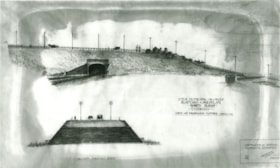
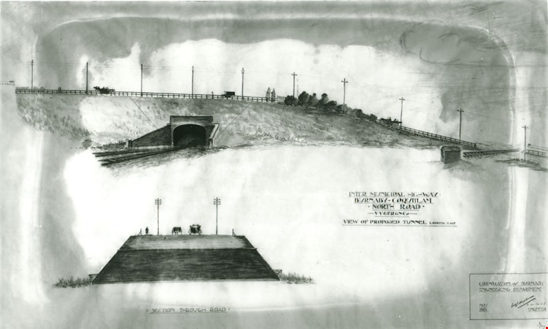
Intermunicipal Highway Burnaby-Coquitlam
https://search.heritageburnaby.ca/link/museumdescription3096
- Repository
- Burnaby Village Museum
- Date
- November 1915
- Collection/Fonds
- Burnaby Village Museum Photograph collection
- Description Level
- Item
- Physical Description
- 1 photograph : b&w glass negative ; 16.5 x 21.3 cm
- Scope and Content
- Photograph of a drawing used for a Burnaby-Coquitlam Intermunicipal Highway tunnel construction proposal. On the top of the page is a drawing of a tunnel running below the bluff on which North Road is laid. On the bottom, is a cross section drawing of the through road. Written on the corner right o…
- Repository
- Burnaby Village Museum
- Collection/Fonds
- Burnaby Village Museum Photograph collection
- Description Level
- Item
- Physical Description
- 1 photograph : b&w glass negative ; 16.5 x 21.3 cm
- Scope and Content
- Photograph of a drawing used for a Burnaby-Coquitlam Intermunicipal Highway tunnel construction proposal. On the top of the page is a drawing of a tunnel running below the bluff on which North Road is laid. On the bottom, is a cross section drawing of the through road. Written on the corner right of the drawing is "INTER MUNICIPAL HIGHWAY / BURNABY-COQUITLAM / NORTH ROAD / -VV&ER&NCo / VIEW OF PROPOSED TUNNEL LOOKING EAST", and on lower right is a box drawn around an engineer's signature, and label, "CORPORATION of BURNABY ENGINEERING DEPARTMENT / NOV. / 1915". The artist of the proposal drawing signed on the lower right corner below the engineer's signature.
- Geographic Access
- North Road
- Accession Code
- HV972.11.10
- Access Restriction
- No restrictions
- Reproduction Restriction
- No known restrictions
- Date
- November 1915
- Media Type
- Photograph
- Scan Resolution
- 300
- Scan Date
- 14/8/2006
- Scale
- 100
- Notes
- Title based on contents of photograph
- 1 b&w contact print accompanying negative
Images

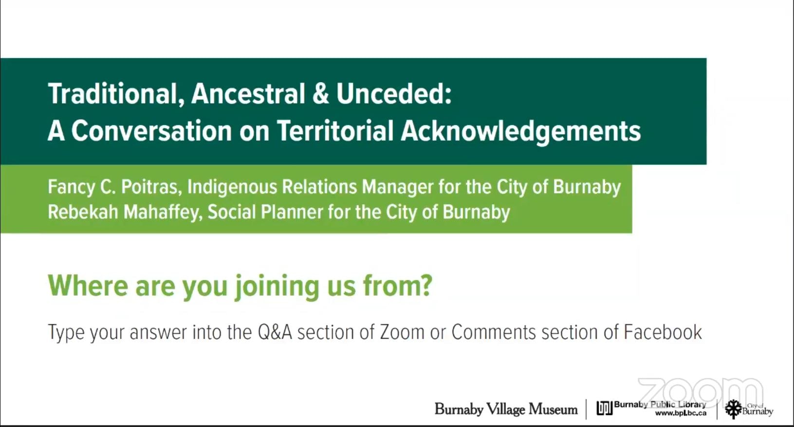
Traditional, Ancestral & Unceded: A Conversation on Territorial Acknowledgements
https://search.heritageburnaby.ca/link/museumdescription15664
- Repository
- Burnaby Village Museum
- Date
- 29 Apr. 2021
- Collection/Fonds
- Burnaby Village Museum fonds
- Description Level
- Item
- Physical Description
- 1 video recording (mp4) (87 min., 17 sec.) : digital, col., sd., stereo ; 29 fps
- Scope and Content
- Item consists of a video recording of a live Zoom webinar hosted by Burnaby Village Museum curator, Jane Lemke. The webinar is titled "Traditional, Ancestral & Unceded: A Conversation on Territorial Acknowledgements" and is presented by Fancy Poitras, Indigenous Relations Manager for the City of Bu…
- Repository
- Burnaby Village Museum
- Collection/Fonds
- Burnaby Village Museum fonds
- Description Level
- Item
- Physical Description
- 1 video recording (mp4) (87 min., 17 sec.) : digital, col., sd., stereo ; 29 fps
- Material Details
- Presenters: Fancy Poitras and Rebekah Mahaffey
- Host: Jane Lemke
- Date of Presentation: Thursday, April 29, 7:00 pm - 8:30 pm
- Total Number of tracks: 1
- Total Length of all tracks: 87 min., 17 sec.
- Recording Device: Zoom video communication platform
- Recording Note: Film was edited from it's original recorded version (95 min., 34 sec.) to edited version (87 min., 17 sec.) for public viewing on Heritage Burnaby. This live recording experienced technical difficulties with the viewer window during the first few minutes of the presentation. This is resolved at 15:36.
- Scope and Content
- Item consists of a video recording of a live Zoom webinar hosted by Burnaby Village Museum curator, Jane Lemke. The webinar is titled "Traditional, Ancestral & Unceded: A Conversation on Territorial Acknowledgements" and is presented by Fancy Poitras, Indigenous Relations Manager for the City of Burnaby and Rebekah Mahaffey, Social Planner for the City of Burnaby. The Zoom webinar is the second in a series of six "Neighbourhood Speaker series" webinars exploring a range of topics shared by Indigenous speakers and knowledge keepers that were presented and made available to the public between April 27 and May 12, 2021. The live webinar was also made available on the Burnaby Village Museum's facebook page. Community members were invited to participate by bringing questions during the interactive online sessions. The webinar opens with host, Jane Lemke providing a Land Acknowlegement "The land on which Burnaby now sits is the ancestral and unceded homelands of the hən̓q̓əmin̓əm and Sḵwx̱wú7mesh speaking peoples". Jane explains that providing a land acknowledgement is part of the City of Burnaby's official policy and that the land is on the shared territory of many Nations including the sq̓əc̓iy̓aɁɬ təməxʷ (Katzie), Kway-quit-lum, Kwantlen, ʷməθkʷəy̓əm (Musqueam), Sḵwx̱wú7mesh, and Tsleil-Waututh Nations. Understanding the definitions of language groups, Nations, shared territory and many of the importance words form a basis of the subject matter for this webinar. Fancy Poitras and Rebekah Mahaffey enter a discussion exploring this topic while posing thought provoking questions to each other. As Burnaby's Indigenous Relations Manager, Fancy Poitras conveys her own experiences and knowledge while providing historical references and recommendations for further educational resources around territorial land acknowledgment. Following their discussion, Fancy and Rebekah take questions from the audience that are moderated by the host, Jane Lemke.
- History
- Fancy Poitras was hired as the City of Burnaby's first Indigenous Relations Manager in 2021. Prior to her role, she worked for the First Nations Health Authority for more than five years, first as a Senior Policy Analyst, then as the Manager and Acting Director of Strategic Policy; throughout her time with FNHA, she worked on an extensive portfolio of health and wellness, and service design and delivery issues, including primary care, cancer, seniors and elders. Fancy has a Master’s degree in Public Policy and a Post-Baccalaureate Diploma in Social Policy Issues from Simon Fraser University, and a Bachelor of Arts in Political Science from University of Alberta. Fancy is a member of Mikisew Cree First Nation, Treaty 8 territory, and she grew up primarily in the Northwest Territories. Rebekah Mahaffey (she, her, hers) is a Social Policy Planner at the City of Burnaby. She is a settler on these lands, and is of mixed French-Scottish-Irish ancestry. She grew up in Indonesia, Libya and England and has called the west coast home for almost 15 years. Rebekah has degrees in International Development, Art History and Urban Planning. In her work she focuses on inter-culturalism, access and inclusion, anti-racism, and working with Burnaby’s 2SLGBTQQIA community. When not at work, she enjoys hiking, reading, and listening to podcasts. She lives in Vancouver with her young child.
- Creator
- Burnaby Village Museum
- Subjects
- Indigenous peoples - British Columbia
- Indigenous peoples - Canada - Government relations
- Indigenous peoples - British Columbia - Languages
- Indigenous peoples - Canada - , Treatment of
- Responsibility
- Lemke, Jane
- Accession Code
- BV021.17.2
- Access Restriction
- No restrictions
- Reproduction Restriction
- No known restrictions
- Date
- 29 Apr. 2021
- Media Type
- Moving Images
- Notes
- Title based on contents of video recording The following links wereshared at the end of the presentation:
- My Conversations with Canadians by Lee Maracle: https://bookhugpress.ca/shop/ebooks/essays-ebooks/conversations-with-canadians-by-lee-maracle/
- 21 Things You May Not Know About the Indian Act by Bob Joseph: https://www.ictinc.ca/books/21-things-you-may-not-know-about-the-indian-act
- CBC documentary series 8th Fire: https://www.cbc.ca/firsthand/blog/8th-fire-wabs-walk-through-history ‘Whose Land’ App: https://apps.apple.com/ca/app/whose-land/id1350310353
- “Unreserved” Podcast, Episode: January 20, 2019, ‘Hayden King’: https://www.cbc.ca/radio/unreserved/redrawing-the-lines-1.4973363/i-regret-it-hayden-king-on-writing-ryerson-university-s-territorial-acknowledgement-1.4973371
- Guidelines for Indigenous Territory Acknowledgement http://www.burnaby.ca/Assets/Burnaby+Interagency/Guidelines+for+Indigenous+Territory+Acknowledgement.pdf
- United Nations Declaration on the Rights of Indigenous Peoples: https://www.un.org/development/desa/indigenouspeoples/declaration-on-the-rights-of-indigenous-peoples.html
- Truth and Reconciliation Commission Calls to Action: http://trc.ca/assets/pdf/Calls_to_Action_English2.pdf
- Missing and Murdered Indigenous Women and Girls Calls for Justice: https://www.mmiwg-ffada.ca/wp-content/uploads/2019/06/Calls_for_Justice.pdf
Images
Video
Traditional, Ancestral & Unceded: A Conversation on Territorial Acknowledgements, 29 Apr. 2021
Traditional, Ancestral & Unceded: A Conversation on Territorial Acknowledgements, 29 Apr. 2021
https://search.heritageburnaby.ca/media/hpo/_Data/_BVM_Moving_Images/2021_0017_0002_002.mp4