Narrow Results By
BC Electric Railway Application for Discontinuation of the Rail Passenger Service on the Marpole Inter-urban Line
https://search.heritageburnaby.ca/link/councilreport43973
- Repository
- City of Burnaby Archives
- Report ID
- 43364
- Meeting Date
- 30-Apr-1956
- Format
- Council - Mayor/Councillor/Staff Report
- Collection/Fonds
- City Council and Office of the City Clerk fonds
- Repository
- City of Burnaby Archives
- Report ID
- 43364
- Meeting Date
- 30-Apr-1956
- Format
- Council - Mayor/Councillor/Staff Report
- Collection/Fonds
- City Council and Office of the City Clerk fonds
Documents
BC Telephone Co. Inter-exchnage
https://search.heritageburnaby.ca/link/councilreport68501
- Repository
- City of Burnaby Archives
- Report ID
- 72993
- Meeting Date
- 13-Oct-1924
- Format
- Council - Mayor/Councillor/Staff Report
- Collection/Fonds
- City Council and Office of the City Clerk fonds
- Repository
- City of Burnaby Archives
- Report ID
- 72993
- Meeting Date
- 13-Oct-1924
- Format
- Council - Mayor/Councillor/Staff Report
- Collection/Fonds
- City Council and Office of the City Clerk fonds
Documents
![Inter-City Golf Driving Range, [195-] (date of original); 2013 (date of duplication) thumbnail](/media/hpo/_Data/_Archives_Images/_Unrestricted/550/557-021.jpg?width=280)
Inter-City Golf Driving Range
https://search.heritageburnaby.ca/link/archivedescription78770
- Repository
- City of Burnaby Archives
- Date
- [195-] (date of original); 2013 (date of duplication)
- Collection/Fonds
- Walker family fonds
- Description Level
- Item
- Physical Description
- 1 photograph (jpeg) : b&w ; 96 dpi
- Scope and Content
- Photograph of the Inter-City Golf Driving Range in Burnaby.
- Repository
- City of Burnaby Archives
- Date
- [195-] (date of original); 2013 (date of duplication)
- Collection/Fonds
- Walker family fonds
- Physical Description
- 1 photograph (jpeg) : b&w ; 96 dpi
- Description Level
- Item
- Record No.
- 557-021
- Access Restriction
- No restrictions
- Reproduction Restriction
- No restrictions
- Accession Number
- 2013-15
- Scope and Content
- Photograph of the Inter-City Golf Driving Range in Burnaby.
- Media Type
- Photograph
- Notes
- Title based on contents of photograph
- Geographic Access
- 10th Avenue
- Historic Neighbourhood
- Edmonds (Historic Neighbourhood)
- Planning Study Area
- Edmonds Area
Images
![Inter-City Golf Driving Range, [195-] (date of original); 2013 (date of duplication) thumbnail](/media/hpo/_Data/_Archives_Images/_Unrestricted/550/557-021.jpg)
![Inter-City Golf Driving Range clubhouse, [1954] (date of original); 2013 (date of duplication) thumbnail](/media/hpo/_Data/_Archives_Images/_Unrestricted/550/557-024.jpg?width=280)
Inter-City Golf Driving Range clubhouse
https://search.heritageburnaby.ca/link/archivedescription78773
- Repository
- City of Burnaby Archives
- Date
- [1954] (date of original); 2013 (date of duplication)
- Collection/Fonds
- Walker family fonds
- Description Level
- Item
- Physical Description
- 1 photograph (jpeg) : b&w ; 300 dpi
- Scope and Content
- Photograph of a tractor attempting to move the Inter-City Golf Driving Range's clubhouse.
- Repository
- City of Burnaby Archives
- Date
- [1954] (date of original); 2013 (date of duplication)
- Collection/Fonds
- Walker family fonds
- Physical Description
- 1 photograph (jpeg) : b&w ; 300 dpi
- Description Level
- Item
- Record No.
- 557-024
- Access Restriction
- No restrictions
- Reproduction Restriction
- No known restrictions
- Accession Number
- 2013-15
- Scope and Content
- Photograph of a tractor attempting to move the Inter-City Golf Driving Range's clubhouse.
- Media Type
- Photograph
- Notes
- Title based on contents of photograph
- Geographic Access
- 10th Avenue
- Historic Neighbourhood
- Edmonds (Historic Neighbourhood)
- Planning Study Area
- Edmonds Area
Images
![Inter-City Golf Driving Range clubhouse, [1954] (date of original); 2013 (date of duplication) thumbnail](/media/hpo/_Data/_Archives_Images/_Unrestricted/550/557-024.jpg)
![Inter-City Golf Driving Range clubhouse, [1954] (date of original); 2013 (date of duplication) thumbnail](/media/hpo/_Data/_Archives_Images/_Unrestricted/550/557-025.jpg?width=280)
Inter-City Golf Driving Range clubhouse
https://search.heritageburnaby.ca/link/archivedescription78774
- Repository
- City of Burnaby Archives
- Date
- [1954] (date of original); 2013 (date of duplication)
- Collection/Fonds
- Walker family fonds
- Description Level
- Item
- Physical Description
- 1 photograph (jpeg) : b&w ; 300 dpi
- Scope and Content
- Photograph of a tractor attempting to move the Inter-City Golf Driving Range's clubhouse.
- Repository
- City of Burnaby Archives
- Date
- [1954] (date of original); 2013 (date of duplication)
- Collection/Fonds
- Walker family fonds
- Physical Description
- 1 photograph (jpeg) : b&w ; 300 dpi
- Description Level
- Item
- Record No.
- 557-025
- Access Restriction
- No restrictions
- Reproduction Restriction
- No known restrictions
- Accession Number
- 2013-15
- Scope and Content
- Photograph of a tractor attempting to move the Inter-City Golf Driving Range's clubhouse.
- Media Type
- Photograph
- Notes
- Title based on contents of photograph
- Geographic Access
- 10th Avenue
- Historic Neighbourhood
- Edmonds (Historic Neighbourhood)
- Planning Study Area
- Edmonds Area
Images
![Inter-City Golf Driving Range clubhouse, [1954] (date of original); 2013 (date of duplication) thumbnail](/media/hpo/_Data/_Archives_Images/_Unrestricted/550/557-025.jpg)
![Inter-City Golf Range, [1952] (date of original); 2013 (date of annotation) thumbnail](/media/hpo/_Data/_Archives_Images/_Unrestricted/550/557-035.jpg?width=280)
Inter-City Golf Range
https://search.heritageburnaby.ca/link/archivedescription78785
- Repository
- City of Burnaby Archives
- Date
- [1952] (date of original); 2013 (date of annotation)
- Collection/Fonds
- Walker family fonds
- Description Level
- Item
- Physical Description
- 1 photograph (jpeg) : b&w ; 96 dpi
- Scope and Content
- Photograph of members of the Walker family teeing off at the Inter-City Golf Range annotated with date, title and identification key.
- Repository
- City of Burnaby Archives
- Date
- [1952] (date of original); 2013 (date of annotation)
- Collection/Fonds
- Walker family fonds
- Physical Description
- 1 photograph (jpeg) : b&w ; 96 dpi
- Description Level
- Item
- Record No.
- 557-035
- Access Restriction
- No restrictions
- Reproduction Restriction
- No known restrictions
- Accession Number
- 2013-15
- Scope and Content
- Photograph of members of the Walker family teeing off at the Inter-City Golf Range annotated with date, title and identification key.
- Media Type
- Photograph
- Notes
- Transcribed title
- Geographic Access
- 10th Avenue
- Historic Neighbourhood
- Edmonds (Historic Neighbourhood)
- Planning Study Area
- Edmonds Area
Images
![Inter-City Golf Range, [1952] (date of original); 2013 (date of annotation) thumbnail](/media/hpo/_Data/_Archives_Images/_Unrestricted/550/557-035.jpg)
Proposal to Place an Old Inter-Urban Tram on Property Lying Between the Burnaby Police Building and the BC Electric Bus Loop at Edmonds Street and Kingsway
https://search.heritageburnaby.ca/link/councilreport42426
- Repository
- City of Burnaby Archives
- Report ID
- 38038
- Meeting Date
- 3-Feb-1958
- Format
- Council - Committee Report
- Collection/Fonds
- City Council and Office of the City Clerk fonds
- Repository
- City of Burnaby Archives
- Report ID
- 38038
- Meeting Date
- 3-Feb-1958
- Format
- Council - Committee Report
- Collection/Fonds
- City Council and Office of the City Clerk fonds
Documents

Masonic Cemetery
https://search.heritageburnaby.ca/link/landmark622
- Repository
- Burnaby Heritage Planning
- Description
- Cemetery site.
- Associated Dates
- 1924
- Street View URL
- Google Maps Street View
- Repository
- Burnaby Heritage Planning
- Geographic Access
- Halifax Street
- Associated Dates
- 1924
- Description
- Cemetery site.
- Heritage Value
- Tucked into a sloping site in a zone that is now transitional between light industrial and residential uses, the Masonic Cemetery is a beautifully landscaped oasis. Two outstanding features of this cemetery are the Woodward mausoleum, constructed in 1924, and the 1930s entrance gates. These substantial gates are constructed of random-coursed granite, and mark the cemetery’s main entrance off Douglas Road. An elaborate granite mausoleum, built for the prominent Woodward family, is located on axis with the main entry, at the brow of the slope. The Egyptian Revival style of the mausoleum was inspired by the opening of Tutankamun’s tomb just two years earlier, a discovery that sparked world-wide Egyptomania. The Woodward’s department store dynasty was founded by Charles Woodward (1852-1937), who visited Vancouver in 1891 and bought two lots for a store. Woodward’s drug department opened in 1895. In 1901, he took an option on a lot at the corner of Hastings and Abbott Streets and incorporated as Woodward’s Department Stores, which opened in November 1903. The family continued to run the business until 1993, when it went bankrupt and was sold to the Hudson’s Bay Company. A number of the Woodward family are interred here.
- Locality
- Vancouver Heights
- Historic Neighbourhood
- Vancouver Heights (Historic Neighbourhood)
- Planning Study Area
- Willingdon Heights Area
- Area
- 60137.87
- Contributing Resource
- Building
- Landscape Feature
- Ownership
- Private
- Street Address
- 4305 Halifax Street
- Street View URL
- Google Maps Street View
Images


Walker family fonds
https://search.heritageburnaby.ca/link/archivedescription78708
- Repository
- City of Burnaby Archives
- Date
- 1948-1957 (date of originals); 2013
- Collection/Fonds
- Walker family fonds
- Description Level
- Fonds
- Physical Description
- 38 photographs (7 jpeg : col., 300 dpi ; 7 jpeg : col., 96 dpi ; 10 jpeg : b&w, 300 dpi ; 12 jpeg : b&w, 96 dpi). 1 drawing (jpeg) : col., 300 dpi ; 2 maps (jpeg) : col. ; 96 dpi ; 397.67 KB of textual records.
- Scope and Content
- Fonds consists of 41 jpegs of original photographs (some include annotation), maps, and newspaper clippings pertaining to Scotty Walker, his family and the Inter-City Driving Range that he created.
- Repository
- City of Burnaby Archives
- Date
- 1948-1957 (date of originals); 2013
- Collection/Fonds
- Walker family fonds
- Physical Description
- 38 photographs (7 jpeg : col., 300 dpi ; 7 jpeg : col., 96 dpi ; 10 jpeg : b&w, 300 dpi ; 12 jpeg : b&w, 96 dpi). 1 drawing (jpeg) : col., 300 dpi ; 2 maps (jpeg) : col. ; 96 dpi ; 397.67 KB of textual records.
- Description Level
- Fonds
- Access Restriction
- No restrictions
- Reproduction Restriction
- May be restricted by third party rights
- Accession Number
- 2013-15
- Scope and Content
- Fonds consists of 41 jpegs of original photographs (some include annotation), maps, and newspaper clippings pertaining to Scotty Walker, his family and the Inter-City Driving Range that he created.
- History
- Scotty Walker purchased the property at 974 12th Avenue in 1948 under the Veteran’s Land Act (VLA) grant from the government. He was in the Air Force during the Second World War. Previous to the purchase he ran a trucking business in New Westminster and lived at 1421 Nanaimo Street. The family consisted of Scotty, his wife Elizabeth, and three children, Alex, Barbara, and James. The land was overgrown with trees, scrub bushes, and a general swampy area. Scotty had the plan to build a Golf Driving Range, but it would take a lot of work. He owned three acres and leased three acres from the Lady of Mercy Church. Then they started working the land. The trees and scrub bush had to be removed and it was all done by hand. As the weather warmed and the swamp dried somewhat, Scotty got the idea to do selective burning. After many times doing this in small sections, the wind changed and the fire was headed for some houses on Tenth Avenue. The fire departments from New Westminster and Burnaby showed up and he was severely punished. It created other problems too. The land was swampy and when it dried, it was a peat bog, so the fire would burn down and turn up all over the place. That winter when the rains came, the land flooded and froze. The kids in the neighbourhood took advantage of the open spaces and brought out their skates. They had a great time. Some pigs were purchased with the idea that they could help dig up the roots and could be butchered later. Well they cleared the roots, but the kids all said they would not eat the pigs. The pigs were sold as they had become like pets. The land was then bulldozed into a berm on the 12th Street side of the land and a fence was built on top of the hill. The Walkers still had to clear the roots and branches that accumulated on the berm. The big problem was snakes. There were pits of water snakes that had been moved with the bulldozing. The family is not sure what happened with the snakes but eventually they moved. The area that would have been to the left of the property was still a swamp, so maybe they went there. The Walkers built drainage ditches through the land and let it drain to the natural slope toward Eighth Street. Construction on the Golf Range started and the grass was seeded. The “Inter-City Golf Range” opened on June 16, 1951. It had been a long hard road for the whole family but it worked out quite well. There was no automatic machine picking up balls, it was all done by hand and washed in a washing machine. Eventually they got Shag Bags that helped some but it was a huge job. The Golf Range ran for a few years and then Burnaby had a very sunny summer and the sun was in the patrons' eyes. So Scotty decided to move the buildings to the 12th Avenue part of the land. The club house and coffee shop was moved. The family took the building apart board by board and reconstructed it at the other end of the land. This worked well. All this had been accomplished on a shoestring budget as there was no big money behind anything. The Walkers cut the grass with gas hand mowers, washed the balls with the washing machine, and worked very long hours. Then the Catholic Church decided not to renew the lease. The family had worked so hard and now Scotty’s dream was dashed. It was a devastating time. Eventually the property was sold to the Christian Brothers and the buildings to Gus Brown in Richmond. The church bought the land for $25,000, in 1957. The end of the dream was very hard on everyone. Eventually life went on. It is sad that Scotty was just so far ahead of his time. He was a small man about 5’6" and about 140 pounds but had dreams as big as anyone and worked like three men to accomplish his dream. The cleared land was eventually developed into Saint Thomas Moore School. Biography provided by B. Kromm
- Media Type
- Photograph
- Creator
- Walker family
- Notes
- Title based on contents of fonds
- Photo catalogue 557
![Charlotte and David Hill on a train, [1921 or 1922] thumbnail](/media/hpo/_Data/_Archives_Images/_Unrestricted/550/550-162.jpg?width=280)
Charlotte and David Hill on a train
https://search.heritageburnaby.ca/link/archivedescription82596
- Repository
- City of Burnaby Archives
- Date
- [1921 or 1922]
- Collection/Fonds
- Hill family and Vidal family fonds
- Description Level
- Item
- Physical Description
- 1 photograph : sepia ; 11 x 6.5 cm
- Scope and Content
- Photograph is a portrait of a woman identified as Charlotte Hill holding David Hill. She is standing on the steps of a train car.
- Repository
- City of Burnaby Archives
- Date
- [1921 or 1922]
- Collection/Fonds
- Hill family and Vidal family fonds
- Physical Description
- 1 photograph : sepia ; 11 x 6.5 cm
- Description Level
- Item
- Record No.
- 550-162
- Access Restriction
- No restrictions
- Reproduction Restriction
- No known restrictions
- Accession Number
- 2013-03
- Scope and Content
- Photograph is a portrait of a woman identified as Charlotte Hill holding David Hill. She is standing on the steps of a train car.
- Media Type
- Photograph
- Notes
- Title based on note accompanying photograph and contents of photograph
- Note in pencil on album pagereads: "Charlotte & David on Burnaby Inter Urban"
- Note in blue pen on verso reads: "Mom & Dave / Burnaby interurban"
Images
![Charlotte and David Hill on a train, [1921 or 1922] thumbnail](/media/hpo/_Data/_Archives_Images/_Unrestricted/550/550-162.jpg)
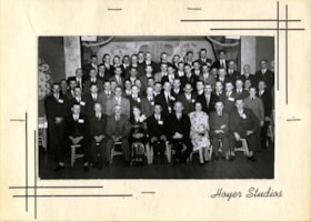
Group at Gai Paree Super Club
https://search.heritageburnaby.ca/link/archivedescription64878
- Repository
- City of Burnaby Archives
- Date
- March 25, 1950
- Collection/Fonds
- Burnaby Historical Society fonds
- Description Level
- Item
- Physical Description
- 1 photograph : b&w ; 8 x 13 cm (sight), in card 12.5 x 35.5 cm folded to 15.5 x 17.5 cm
- Scope and Content
- Photograph of a large group of people at the Gai Paree Supper Club. George Grant and his wife are identified as the second and third from the right in the first row; all other individuals are unidentified.
- Repository
- City of Burnaby Archives
- Date
- March 25, 1950
- Collection/Fonds
- Burnaby Historical Society fonds
- Subseries
- Richard Hardy family subseries
- Physical Description
- 1 photograph : b&w ; 8 x 13 cm (sight), in card 12.5 x 35.5 cm folded to 15.5 x 17.5 cm
- Material Details
- Photograph is housed inside a souvenir card
- Description Level
- Item
- Record No.
- 312-005
- Access Restriction
- No restrictions
- Reproduction Restriction
- Reproduce for fair dealing purposes only
- Accession Number
- BHS1993-09
- Scope and Content
- Photograph of a large group of people at the Gai Paree Supper Club. George Grant and his wife are identified as the second and third from the right in the first row; all other individuals are unidentified.
- Subjects
- Events - Parties
- Media Type
- Photograph
- Photographer
- Hoyer Studios
- Notes
- Title based on contents of photograph
- Front cover of souvenir card reads: "Souvenir Photo / Gai Paree Supper Club / on Kingsway / Your Friendly Inter City Rendezvous / DEx. 4505 / Between Vancouver & New Westminster, B.C. Canada / Featuring Rudy Morin & His Orchestra / Canada's Liveliest Band"
- Inside front cover of souvenir card reads: "Hoyer Studios / 2321 Kingsway (Burnaby, B.C.) Canada / Photographers / Gai Paree Provides Free Personal Table Cards For Birthdays & Anneversaries [sp] / To reorder No. Scouts / Have this Photo Enlarged to any size / Phone Particulars DEx. 4504"
- Photographers name on recto of mat reads: "Hoyer Studios"
- Geographic Access
- Kingsway
- Street Address
- 6669 Kingsway
- Historic Neighbourhood
- Edmonds (Historic Neighbourhood)
- Planning Study Area
- Kingsway-Beresford Area
Images

Subdivision Control series
https://search.heritageburnaby.ca/link/archivedescription187
- Repository
- City of Burnaby Archives
- Date
- 1940-2015
- Collection/Fonds
- Planning Department fonds
- Description Level
- Series
- Scope and Content
- Series consists of the records created during the subdivision application process. This includes the initial application made by the property owner(s), the relevant reports and recommendations by outside departments and agencies, inter- and extra-office communication and correspondence, receipts o…
- Repository
- City of Burnaby Archives
- Date
- 1940-2015
- Collection/Fonds
- Planning Department fonds
- Series
- Subdivision Control series
- Description Level
- Series
- Scope and Content
- Series consists of the records created during the subdivision application process. This includes the initial application made by the property owner(s), the relevant reports and recommendations by outside departments and agencies, inter- and extra-office communication and correspondence, receipts of fees paid, maps, plans, architectural drawings, tentative approval checklists, right-of-way agreements, easements, covenants, road closure references, Title Search Certificates, and final approval checklists.
- Media Type
- Textual Record
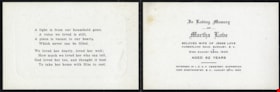
Memorial cards for Martha Love
https://search.heritageburnaby.ca/link/museumdescription10093
- Repository
- Burnaby Village Museum
- Date
- 1920
- Collection/Fonds
- Love family fonds
- Description Level
- File
- Physical Description
- 1 folder of textual records
- Scope and Content
- File consists of a three memorial cards for Martha Love which read: "In Loving Memory / OF / Martha Love / BELOVED WIFE OF JESSE LOVE / CUMBERLAND ROAD, BURNABY, B.C. / Died August 24RD. 1920 / AGED 62 YEARS / INTERRED IN I.O.O.F. CEMETERY, SAPPERTON / NEW WESTMINSTER, B.C., AUGUST 26TH, 1920". A s…
- Repository
- Burnaby Village Museum
- Collection/Fonds
- Love family fonds
- Description Level
- File
- Physical Description
- 1 folder of textual records
- Scope and Content
- File consists of a three memorial cards for Martha Love which read: "In Loving Memory / OF / Martha Love / BELOVED WIFE OF JESSE LOVE / CUMBERLAND ROAD, BURNABY, B.C. / Died August 24RD. 1920 / AGED 62 YEARS / INTERRED IN I.O.O.F. CEMETERY, SAPPERTON / NEW WESTMINSTER, B.C., AUGUST 26TH, 1920". A short, religious poem is printed on the inside face of the card. "IN LOVING / MEMORY" with an image of a rose is printed on the front face of the card.
- History
- See extensive history of Love Family and Love farmhouse located at Burnaby Village Museum.
- Accession Code
- BV012.31.25
- Access Restriction
- No restrictions
- Reproduction Restriction
- No known restrictions
- Date
- 1920
- Media Type
- Textual Record
- Scan Resolution
- 600
- Scan Date
- 7-May-20
- Scale
- 100
- Notes
- Title based on content of file
Images
