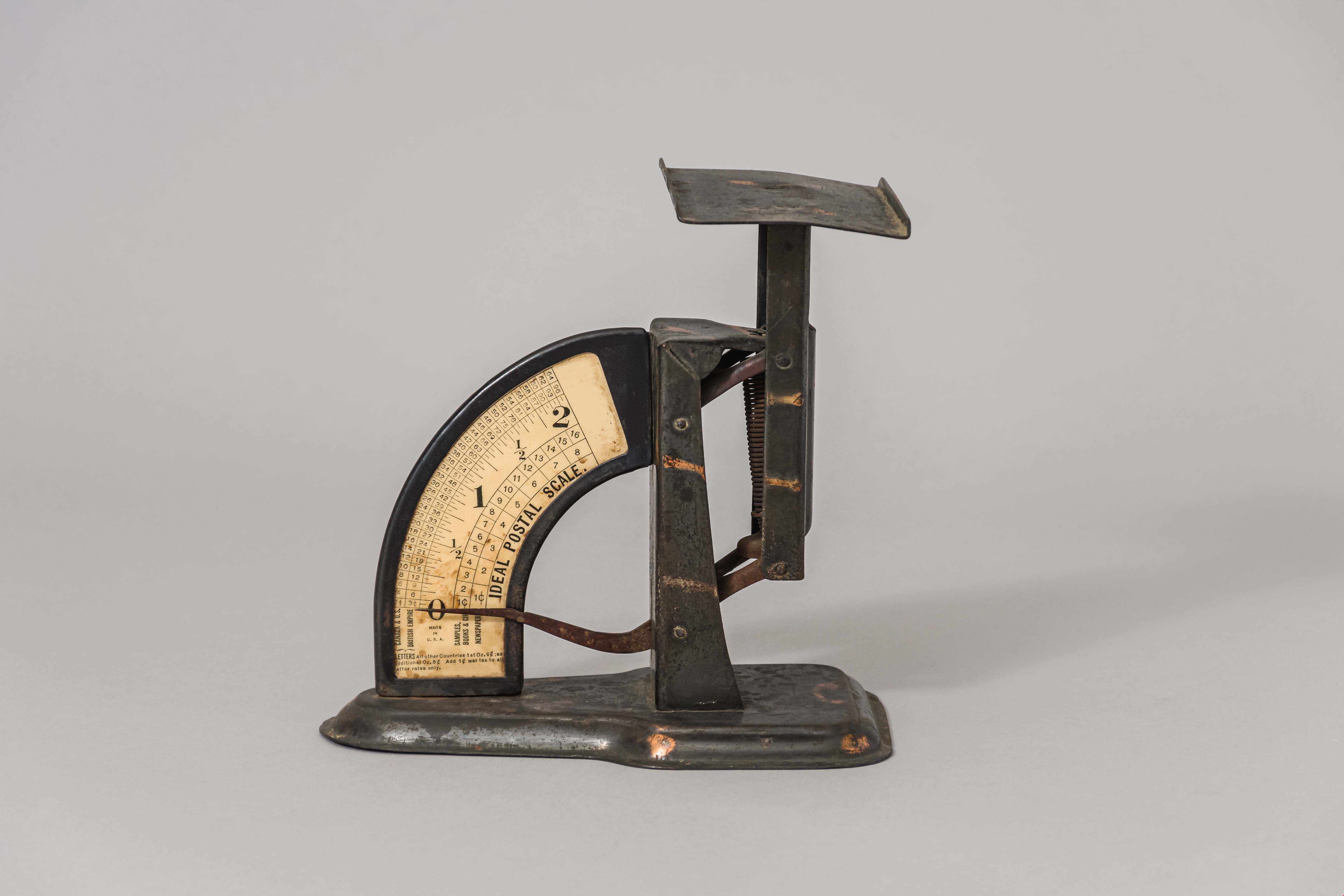
Narrow Results By

postal scale
https://search.heritageburnaby.ca/link/museumartifact15965
- Repository
- Burnaby Village Museum
- Accession Code
- HV983.61.3
- Description
- Postal scale, "IDEAL POSTAL SCALE"
- Object History
- Postal scale used by Harriet Woodward at the Burnaby Lake Post Office. The Burnaby Lake Post Office was run out of the Woodward cottage, owned by Harriet and Maude Woodward. The cottage was a prefabricated cottage erected in 1904. Harriet also began a small private school in the cottage, the first in Burnaby Lake. The cottage was enlarged with several additions until 1912 when the Woodwards built a new house.
- Classification
- Weights and Measurements Tools and Equipment - Scales
- Object Term
- Scale, Postal
- Geographic Access
- Sperling Avenue
- Street Address
- 5141 Sperling Avenue
- Historic Neighbourhood
- Burnaby Lake (Historic Neighbourhood)
- Planning Study Area
- Morley-Buckingham Area
Images

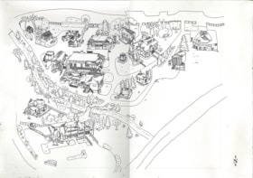
Bird's Eye View of the Burnaby Lake Area
https://search.heritageburnaby.ca/link/museumdescription15144
- Repository
- Burnaby Village Museum
- Date
- 1977
- Collection/Fonds
- Century Park Museum Association fonds
- Description Level
- Item
- Physical Description
- 1 map : b&w print on paper ; 43 x 63.5 cm
- Scope and Content
- Item consists of a map titled "Birds Eye View of the Burnaby Lake Area Circa 1910". The overview of the Burnaby Lake area was compiled and drawn at Heritage Village by curator John Adams and artist, Carol Swan. The map identifies the Burnaby Lake inter-urban tram line; roads including: Sperling Ave…
- Repository
- Burnaby Village Museum
- Collection/Fonds
- Century Park Museum Association fonds
- Description Level
- Item
- Physical Description
- 1 map : b&w print on paper ; 43 x 63.5 cm
- Material Details
- Scale indeterminable
- Scope and Content
- Item consists of a map titled "Birds Eye View of the Burnaby Lake Area Circa 1910". The overview of the Burnaby Lake area was compiled and drawn at Heritage Village by curator John Adams and artist, Carol Swan. The map identifies the Burnaby Lake inter-urban tram line; roads including: Sperling Avenue (Pole Line Road); Gilpin Avenue; Douglas Road; trail to Vancouver Westminster Road (Kingsway); Buckingham Avenue; Haszard Street; various farms and residences including: Charles Sprott "Norland"; H.T. Ceperley "Fairacres"; Claude Hill's "Brookfield farm" and "Broadview"; F.J. Hart's "Avalon"; Miss Woodward's former and new home, school and post office; Councillor Edgar's hunting cabin; Edgar Sprott's "Mayfield farm" and "Mayfield Lodge"; F.J. Peers "Greyfriars"; Arthur de Windt Haszard; Bernard Hill's boathouse as well as other landmarks including: Doran's Mill; tram stations; Burnaby Lake Store; logging camps; wood cutter's shacks; ice houses; cranberry bog; Still Creek; Deer Lake; Burnaby Lake; Deer Lake Creek; Provincial Government Reserve Proposed Hospital (later Oakalla Prison).
- Creator
- Adams, John
- Swan, Carol
- Names
- Hill, Arthur Claude
- Sprott, Charles Frederick
- Sprott, Louis "Edgar"
- Hart, Frederick John, 1884-1945
- Ceperley, H.T.
- Woodward, Maude
- Woodward, Harriet
- Peers, Francis J.
- Haszard, Arthur de Windt
- Hill, Bernard R.
- Geographic Access
- Deer Lake Avenue
- Sperling Avenue
- Haszard Street
- Buckingham Avenue
- Accession Code
- BV021.1.3
- Access Restriction
- No restrictions
- Reproduction Restriction
- No known restrictions
- Date
- 1977
- Media Type
- Cartographic Material
- Historic Neighbourhood
- Burnaby Lake (Historic Neighbourhood)
- Planning Study Area
- Burnaby Lake Area
- Related Material
- See also: Life with the Moores of Hart House : pioneer days on Burnaby's Deer Lake
- Scan Resolution
- 600
- Scan Date
- 2021-11-12
- Scale
- 100
- Notes
- Transcribed title
- Compiled by John Adams; illustration by Carol Swan
- The map depicts the Burnaby Lake Tram Line as being double tracked, whereas in reality it was single tracked.
- Map is part of the book "Life with the Moores of Hart House : pioneer days on Burnaby's Deer Lake https://search.heritageburnaby.ca/permalink/museumlibrary6314-102
Images


Bird's Eye View of the Burnaby Lake Area
https://search.heritageburnaby.ca/link/museumdescription17543
- Repository
- Burnaby Village Museum
- Date
- 1977
- Collection/Fonds
- Century Park Museum Association fonds
- Description Level
- Item
- Physical Description
- 1 map : b&w print with watercolour ; 43 x 63.5 cm
- Scope and Content
- Item consists of a map titled "Birds Eye View of the Burnaby Lake Area Circa 1910". The overview of the Burnaby Lake area was compiled and drawn at Heritage Village by curator John Adams and artist, Carol Swan. The map identifies the Burnaby Lake inter-urban tram line; roads including: Sperling Ave…
- Repository
- Burnaby Village Museum
- Collection/Fonds
- Century Park Museum Association fonds
- Description Level
- Item
- Physical Description
- 1 map : b&w print with watercolour ; 43 x 63.5 cm
- Material Details
- Scale indeterminable
- Scope and Content
- Item consists of a map titled "Birds Eye View of the Burnaby Lake Area Circa 1910". The overview of the Burnaby Lake area was compiled and drawn at Heritage Village by curator John Adams and artist, Carol Swan. The map identifies the Burnaby Lake inter-urban tram line; roads including: Sperling Avenue (Pole Line Road); Gilpin Avenue; Douglas Road; trail to Vancouver Westminster Road (Kingsway); Buckingham Avenue; Haszard Street; various farms and residences including: Charles Sprott "Norland"; H.T. Ceperley "Fairacres"; Claude Hill's "Brookfield farm" and "Broadview"; F.J. Hart's "Avalon"; Miss Woodward's former and new home, school and post office; Councillor Edgar's hunting cabin; Edgar Sprott's "Mayfield farm" and "Mayfield Lodge"; F.J. Peers "Greyfriars"; Arthur de Windt Haszard; Bernard Hill's boathouse as well as other landmarks including: Doran's Mill; tram stations; Burnaby Lake Store; logging camps; wood cutter's shacks; ice houses; cranberry bog; Still Creek; Deer Lake; Burnaby Lake; Deer Lake Creek; Provincial Government Reserve Proposed Hospital (later Oakalla Prison).
- Creator
- Adams, John
- Swan, Carol
- Names
- Hill, Arthur Claude
- Sprott, Charles Frederick
- Sprott, Louis "Edgar"
- Hart, Frederick John, 1884-1945
- Ceperley, H.T.
- Woodward, Maude
- Woodward, Harriet
- Peers, Francis J.
- Haszard, Arthur de Windt
- Hill, Bernard R.
- Geographic Access
- Deer Lake Avenue
- Sperling Avenue
- Haszard Street
- Buckingham Avenue
- Accession Code
- BV021.1.4
- Access Restriction
- No restrictions
- Reproduction Restriction
- No known restrictions
- Date
- 1977
- Media Type
- Cartographic Material
- Historic Neighbourhood
- Burnaby Lake (Historic Neighbourhood)
- Planning Study Area
- Burnaby Lake Area
- Related Material
- See also: Life with the Moores of Hart House : pioneer days on Burnaby's Deer Lake
- Scan Resolution
- 600
- Scan Date
- 2021-11-12
- Scale
- 100
- Notes
- Transcribed title
- Compiled by John Adams; illustration by Carol Swan
- The map depicts the Burnaby Lake Tram Line as being double tracked, whereas in reality it was single tracked.
- Map is part of the book "Life with the Moores of Hart House : pioneer days on Burnaby's Deer Lake https://search.heritageburnaby.ca/permalink/museumlibrary6314-102
- This is a print made from original illustration and appears to be hand-coloured with watercolour at a later date.
Images

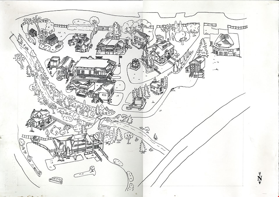
drawing
https://search.heritageburnaby.ca/link/museumartifact91041
- Repository
- Burnaby Village Museum
- Accession Code
- BV020.5.1688
- Description
- Drawing; black ink and pencil on Arches white paper; drawn by Carly Bouwman (unsigned); bird's eye view (site plan) of Burnaby Village Museum site; illustration includes buildings on the site including Adminstration building and parking lot (in foreground); the Love farmhouse; bridge across creek; Tom Irvine house; Village Church; Tram barn; Carousel building; Elworth house; bandstand; Elworth garage; buildings on west side of Hill Street including Japanese Ofuro; Log Cabin; Steam Shed; Blacksmith shop; Old Curly Locomotive; Deer Lake Auto; General Store; Stride Studios; Drug Store and McKay Barbershop and east side of Hill Street including the Real Estate Office; Royal Bank; Music Shop; Burnaby Post; Chinese Herbalist shop; Home Bakery and Ice Cream Parlour; Vancouver Heights Sheet Metal Works; Bell's Dry Goods; Seaforth School; illustration also includes geographic features such as roads; trees; gardens and creek [ca. 2000]
- Object History
- Part of Burnaby Village Museum Administrative Design collection.
- Category
- 08. Communication Artifacts
- Classification
- Documentary Artifacts - - Other Documents
- Object Term
- Drawing
- Colour
- Black
- White
- Measurements
- 39.5 cm x 57 cm
- Maker
- Bouwman, Carly
- Province Made
- British Columbia
- Subjects
- Documentary Artifacts
Images
postcard
https://search.heritageburnaby.ca/link/museumartifact44487
- Repository
- Burnaby Village Museum
- Accession Code
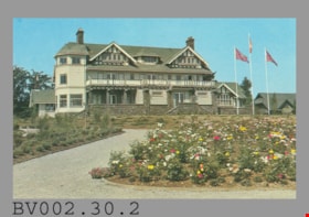
- BV002.30.2
- Description
- Postcard: colour photo of large house in garden, flagpoles; horizontal; on reverse in navy, "No. 5" "CENTURY GARDENS" "Burnaby, B.C., Canada" "Century Gardens was Burnaby's Centennial Project... Canada's 100th birthday... north shore of Deer Lake... Burnaby's new Art Centre...", the restored heritage house "Fairacres", later "Burnaby Art Gallery"; illustration at left of R.C.M.P. officer; at bottom, "Photo by George Allen Aerial Photos Ltd." "S-2796"; navy bar up centre "NATURAL COLOR PRODUCTIONS, LTD., VANCOUVER, B.C."; at bottom, "MADE IN CANADA" "GRANT-MANN" and logo; at upper right, illustration of mounted R.C.M.P. officer, "POST CARD" "ADDRESS", rectangle "USE CANADIAN POSTAGE"; in blue pen at left, "We saw this July 1977"
- Classification
- Written Communication T&E - - Writing Media
- Object Term
- Postcard
- Country Made
- Canada
- Province Made
- British Columbia
- Site/City Made
- Vancouver
- Title
- Century Gardens Burnaby, B.C., Canada S-2796
- Subjects
- Souvenirs
- Names
- Burnaby Art Gallery
Images


postcard
https://search.heritageburnaby.ca/link/museumartifact45258
- Repository
- Burnaby Village Museum
- Accession Code
- BV003.5.1
- Description
- Postcard: colour photo of large house in garden, flagpoles; horizontal; on reverse in navy, "No. 5" "CENTURY GARDENS" "Burnaby, B.C., Canada" "Century Gardens was Burnaby's Centennial Project... Canada's 100th birthday... north shore of Deer Lake... Burnaby's new Art Centre...", the restored heritage house "Fairacres", later "Burnaby Art Gallery"; illustration at left of R.C.M.P. officer; at bottom, "Photo by George Allen Aerial Photos Ltd." "S-2796"; navy bar up centre "NATURAL COLOR PRODUCTIONS, LTD., VANCOUVER, B.C."; at bottom, "MADE IN CANADA" "GRANT-MANN" and logo; at upper right, illustration of mounted R.C.M.P. officer, "POST CARD" "ADDRESS", rectangle "USE CANADIAN POSTAGE"; unused
- Object History
- Purchased on E-Bay.
- Classification
- Written Communication T&E - - Writing Media
- Object Term
- Postcard
- Country Made
- Canada
- Province Made
- British Columbia
- Site/City Made
- Vancouver
- Title
- Century Gardens Burnaby, B.C., Canada S-2796
- Subjects
- Documentary Artifacts
- Documentary Artifacts - Postcards
- Documentary Artifacts - Photographs
- Buildings
- Buildings - Civic
- Buildings - Civic - Art Galleries
- Names
- Burnaby Art Gallery
Images

postcard
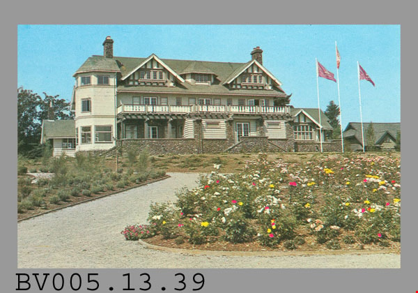
https://search.heritageburnaby.ca/link/museumartifact48256
- Repository
- Burnaby Village Museum
- Accession Code
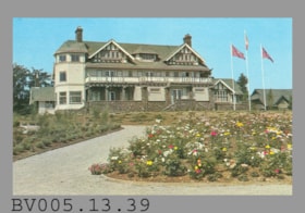
- BV005.13.39
- Description
- Postcard: colour photo of large house in garden, flagpoles; horizontal; on reverse in navy, "No. 5" "CENTURY GARDENS" "Burnaby, B.C., Canada" "Century Gardens was Burnaby's Centennial Project... Canada's 100th birthday... north shore of Deer Lake... Burnaby's new Art Centre...", the restored heritage house "Fairacres", later "Burnaby Art Gallery"; illustration at left of R.C.M.P. officer; at bottom, "Photo by George Allen Aerial Photos Ltd." "S-2796"; navy bar up centre "NATURAL COLOR PRODUCTIONS, LTD., VANCOUVER, B.C."; at bottom, "MADE IN CANADA" "GRANT-MANN" and logo; at upper right, illustration of mounted R.C.M.P. officer, "POST CARD" "ADDRESS", rectangle "USE CANADIAN POSTAGE"; unused
- Classification
- Written Communication T&E - - Writing Media
- Object Term
- Postcard
- Marks/Labels
- No.5 / Century Gardens / Burnaby, B.C., Canada / ..Burnaby's Centennial Project Commemorating Canada's 100th Birthday..
- Country Made
- Canada
- Province Made
- British Columbia
- Site/City Made
- Vancouver
- Title
- Century Gardens Burnaby, B.C., Canada S-2796
- Subjects
- Documentary Artifacts
- Documentary Artifacts - Postcards
- Documentary Artifacts - Photographs
- Buildings
- Buildings - Civic
- Buildings - Civic - Art Galleries
- Names
- Burnaby Art Gallery
Images