Narrow Results By
Subject
- Agriculture - Farms 1
- Agriculture - Fruit and Berries 1
- Animals - Dogs 2
- Buildings - Civic - City Halls 1
- Buildings - Heritage 3
- Buildings - Residential - Houses
- Cemeteries 1
- Documentary Artifacts - Postcards 1
- Events - Anniversaries 1
- Geographic Features - Gardens 1
- Musical Instruments - Pianos 1
- Natural Phenomena - Snow 1
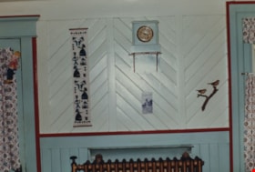
Love farmhouse kitchen wall
https://search.heritageburnaby.ca/link/museumdescription1121
- Repository
- Burnaby Village Museum
- Date
- 1971 (date of original), copied 1990
- Collection/Fonds
- Love family fonds
- Description Level
- Item
- Physical Description
- 1 photograph : col. ; 10 x 15 cm print
- Scope and Content
- Photograph of a wall in the Love farmhouse kitchen while Elsie (nee Love) Hughes, her husband John and son Brent lived in the house. The tongue and groove walls are painted white with teal blue borders and burgundy trim. A small clock sits on top of shelf on the wall. There is a narrow printed fabr…
- Repository
- Burnaby Village Museum
- Collection/Fonds
- Love family fonds
- Description Level
- Item
- Physical Description
- 1 photograph : col. ; 10 x 15 cm print
- Material Details
- Copy print was made from re-photographing an original colour slide
- Scope and Content
- Photograph of a wall in the Love farmhouse kitchen while Elsie (nee Love) Hughes, her husband John and son Brent lived in the house. The tongue and groove walls are painted white with teal blue borders and burgundy trim. A small clock sits on top of shelf on the wall. There is a narrow printed fabric banner hanging to the left and a relief of two birds sitting on a branch to the right. The original tongue and groove walls were built by George Love (Elsie's uncle). The house was located at 7651 Cumberland Street (Address pre 1960: 1390 Cumberland Road) and was moved from its original site to the Burnaby Village Museum in 1988 and designated a Municipal Heritage Landmark in 1992.
- Geographic Access
- Cumberland Street
- Street Address
- 7651 Cumberland Street
- Accession Code
- BV992.15.2
- Access Restriction
- Restricted access
- Reproduction Restriction
- May be restricted by third party rights
- Date
- 1971 (date of original), copied 1990
- Media Type
- Photograph
- Historic Neighbourhood
- East Burnaby (Historic Neighbourhood)
- Planning Study Area
- Cariboo-Armstrong Area
- Scan Resolution
- 600
- Scan Date
- 01-Jun-09
- Scale
- 100
- Photographer
- Parker, Albert "Bert"
- Notes
- Title based on contents of photograph
Images

![Love farmhouse in winter, [1900] (date of original), copied [1988] thumbnail](/media/hpo/_Data/_BVM_Images/2018/2018_0041_0202_001.jpg?width=280)
Love farmhouse in winter
https://search.heritageburnaby.ca/link/museumdescription9960
- Repository
- Burnaby Village Museum
- Date
- [1900] (date of original), copied [1988]
- Collection/Fonds
- Burnaby Village Museum fonds
- Description Level
- Item
- Physical Description
- 1 photograph : col. slide ; 35 mm
- Scope and Content
- Photograph of the Love family farmhouse located at 1390 Cumberland Road (later renumbered 7651 Cumberland Street), East Burnaby. A mature conifer tree sits next to the house, both are covered in snow. The house was built by Jesse Love with the help of George Salt in 1893. In 1988, this house was mo…
- Repository
- Burnaby Village Museum
- Collection/Fonds
- Burnaby Village Museum fonds
- Series
- Jesse Love farmhouse series
- Subseries
- Love family photographs subseries
- Description Level
- Item
- Physical Description
- 1 photograph : col. slide ; 35 mm
- Scope and Content
- Photograph of the Love family farmhouse located at 1390 Cumberland Road (later renumbered 7651 Cumberland Street), East Burnaby. A mature conifer tree sits next to the house, both are covered in snow. The house was built by Jesse Love with the help of George Salt in 1893. In 1988, this house was moved to the site of the Burnaby Village Museum at 6501 Deer Lake Avenue where it was restored to the 1920s era.
- Geographic Access
- Cumberland Street
- Street Address
- 7651 Cumberland Street
- Accession Code
- BV018.41.202
- Access Restriction
- No restrictions
- Reproduction Restriction
- May be restricted by third party rights
- Date
- [1900] (date of original), copied [1988]
- Media Type
- Photograph
- Historic Neighbourhood
- East Burnaby (Historic Neighbourhood)
- Planning Study Area
- Cariboo-Armstrong Area
- Scan Resolution
- 2400
- Scan Date
- 4-Mar-2019
- Scale
- 100
- Notes
- Title based on contents of photograph
- Annotation on bottom of photograph reads: "1390 Cumberland Rd, the old home"
Images
![Love farmhouse in winter, [1900] (date of original), copied [1988] thumbnail](/media/hpo/_Data/_BVM_Images/2018/2018_0041_0202_001.jpg)