Narrow Results By
Decade
- 2020s 237
- 2010s 279
- 2000s 1537
- 1990s
- 1980s 1544
- 1970s 3674
- 1960s 1619
- 1950s 1938
- 1940s 2430
- 1930s 2371
- 1920s 2607
- 1910s 2095
- 1900s 838
- 1890s 244
- 1880s 161
- 1870s 72
- 1860s 120
- 1850s 14
- 1840s 6
- 1830s 3
- 1820s 3
- 1810s 4
- 1800s 4
- 1790s 3
- 1780s 3
- 1770s 3
- 1760s 3
- 1750s 3
- 1740s 3
- 1730s 3
- 1720s 3
- 1710s 3
- 1700s 3
- 1690s 3
- 1680s 3
- 1670s 2
- 1660s 2
- 1650s 2
- 1640s 2
- 1630s 2
- 1620s 2
- 1610s 2
- 1600s
- 1590s 1
- 1580s 1
- 1570s 1
- 1560s 1
- 1550s 1
- 1540s 1
- 1530s 1
- 1520s 2
- 1510s 1
- 1500s 1
- 1490s 1
- 1480s 1
Board of Variance Ledger - August 1973 - July 1992
https://search.heritageburnaby.ca/link/archivedescription5951
- Repository
- City of Burnaby Archives
- Date
- 1973-1992
- Collection/Fonds
- City Council and Office of the City Clerk fonds
- Description Level
- Item
- Physical Description
- Textual record
- Scope and Content
- Includes the Board of Variance number, appellants' name and address, the legal description, nature of the appeal, decision, and date.
- Repository
- City of Burnaby Archives
- Date
- 1973-1992
- Collection/Fonds
- City Council and Office of the City Clerk fonds
- Series
- Zoning and Rezoning series
- Physical Description
- Textual record
- Description Level
- Item
- Record No.
- 8902
- Accession Number
- 2001-05
- Scope and Content
- Includes the Board of Variance number, appellants' name and address, the legal description, nature of the appeal, decision, and date.
- Media Type
- Textual Record
Burnaby's Central Park Tramline Walking Tour
https://search.heritageburnaby.ca/link/archivedescription56653
- Repository
- City of Burnaby Archives
- Date
- 1991
- Collection/Fonds
- Planning Department fonds
- Description Level
- Item
- Physical Description
- 1 booklet
- Scope and Content
- Booklet provides a guide to a self-guided tour along the historic sites of Burnaby's BC Parkway and Highland Park Line.
- Repository
- City of Burnaby Archives
- Date
- 1991
- Collection/Fonds
- Planning Department fonds
- Physical Description
- 1 booklet
- Description Level
- Item
- Record No.
- 40079
- Accession Number
- 2008-16
- Scope and Content
- Booklet provides a guide to a self-guided tour along the historic sites of Burnaby's BC Parkway and Highland Park Line.
- Media Type
- Textual Record
Lougheed Town Centre Plan Map
https://search.heritageburnaby.ca/link/archivedescription56654
- Repository
- City of Burnaby Archives
- Date
- 1997
- Collection/Fonds
- Planning Department fonds
- Description Level
- Item
- Physical Description
- 1 map
- Scope and Content
- Map shows the land use concept and design plan for the Lougheed Town Centre.
- Repository
- City of Burnaby Archives
- Date
- 1997
- Collection/Fonds
- Planning Department fonds
- Physical Description
- 1 map
- Description Level
- Item
- Record No.
- 40080
- Accession Number
- 2008-16
- Scope and Content
- Map shows the land use concept and design plan for the Lougheed Town Centre.
- Media Type
- Textual Record
- Cartographic Material
City of Burnaby Community Plans 1993
https://search.heritageburnaby.ca/link/archivedescription56658
- Repository
- City of Burnaby Archives
- Date
- 1993
- Collection/Fonds
- Planning Department fonds
- Description Level
- Item
- Physical Description
- Textual record
- Repository
- City of Burnaby Archives
- Date
- 1993
- Collection/Fonds
- Planning Department fonds
- Physical Description
- Textual record
- Description Level
- Item
- Record No.
- 40084
- Accession Number
- 2008-16
- Media Type
- Textual Record
City of Burnaby Community Plans 1992
https://search.heritageburnaby.ca/link/archivedescription56662
- Repository
- City of Burnaby Archives
- Date
- 1992
- Collection/Fonds
- Planning Department fonds
- Description Level
- Item
- Physical Description
- Textual record
- Repository
- City of Burnaby Archives
- Date
- 1992
- Collection/Fonds
- Planning Department fonds
- Physical Description
- Textual record
- Description Level
- Item
- Record No.
- 40088
- Accession Number
- 2008-16
- Media Type
- Textual Record
Certificate of Appreciation
https://search.heritageburnaby.ca/link/archivedescription57836
- Repository
- City of Burnaby Archives
- Date
- 1999
- Collection/Fonds
- Burnaby Historical Society fonds
- Description Level
- Item
- Physical Description
- 1 certificate
- Scope and Content
- Item is a Certificate of Appreciation from Burnaby School District 41 to the Burnaby Clef Society "in recognition of your ongoing support and involvement with the Burnaby School District's Career Preparation and Work Experience programs."
- Repository
- City of Burnaby Archives
- Date
- 1999
- Collection/Fonds
- Burnaby Historical Society fonds
- Subseries
- Burnaby Clef Society subseries
- Physical Description
- 1 certificate
- Description Level
- Item
- Record No.
- MSS020-029
- Accession Number
- BHS2007-04
- Scope and Content
- Item is a Certificate of Appreciation from Burnaby School District 41 to the Burnaby Clef Society "in recognition of your ongoing support and involvement with the Burnaby School District's Career Preparation and Work Experience programs."
- Media Type
- Textual Record
- Notes
- Title based on contents of item
- Certificate originally framed in plexiglass silver frame
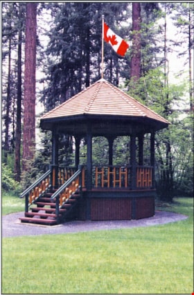
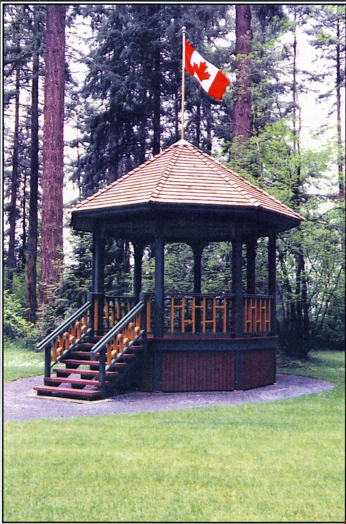
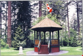
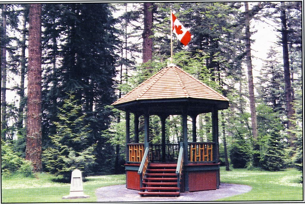
Reconstructed Central Park Bandstand
https://search.heritageburnaby.ca/link/archivedescription58424
- Repository
- City of Burnaby Archives
- Date
- 1996
- Collection/Fonds
- Burnaby Historical Society fonds
- Description Level
- Item
- Physical Description
- 1 photographic postcard : col.
- Scope and Content
- Photographic postcard of the reconstructed Central Park Bandstand used to promote its official opening taking place May 29, 1996 (to be described).
- Repository
- City of Burnaby Archives
- Date
- 1996
- Collection/Fonds
- Burnaby Historical Society fonds
- Subseries
- Pixie McGeachie subseries
- Physical Description
- 1 photographic postcard : col.
- Description Level
- Item
- Record No.
- 332-002
- Access Restriction
- No restrictions
- Reproduction Restriction
- No restrictions
- Accession Number
- BHS1996-16
- Scope and Content
- Photographic postcard of the reconstructed Central Park Bandstand used to promote its official opening taking place May 29, 1996 (to be described).
- Media Type
- Photograph
- Geographic Access
- Central Park
- Imperial Street
- Street Address
- 3883 Imperial Street
- Historic Neighbourhood
- Central Park (Historic Neighbourhood)
- Planning Study Area
- Maywood Area
Images
Reconstructed Central Park Bandstand
https://search.heritageburnaby.ca/link/archivedescription58425
- Repository
- City of Burnaby Archives
- Date
- 1996
- Collection/Fonds
- Burnaby Historical Society fonds
- Description Level
- Item
- Physical Description
- 1 photographic postcard : col.
- Scope and Content
- Photographic postcard of the reconstructed Central Park Bandstand used to promote its official opening taking place May 29, 1996.
- Repository
- City of Burnaby Archives
- Date
- 1996
- Collection/Fonds
- Burnaby Historical Society fonds
- Subseries
- Pixie McGeachie subseries
- Physical Description
- 1 photographic postcard : col.
- Description Level
- Item
- Record No.
- 332-003
- Access Restriction
- No restrictions
- Reproduction Restriction
- Reproduce for fair dealing purposes only
- Accession Number
- BHS1996-16
- Scope and Content
- Photographic postcard of the reconstructed Central Park Bandstand used to promote its official opening taking place May 29, 1996.
- Media Type
- Photograph
- Geographic Access
- Central Park
- Imperial Street
- Street Address
- 3883 Imperial Street
- Historic Neighbourhood
- Central Park (Historic Neighbourhood)
- Planning Study Area
- Maywood Area
Images
The Burnaby Health Department Centennial 1992
https://search.heritageburnaby.ca/link/archivedescription58426
- Repository
- City of Burnaby Archives
- Date
- 1992
- Collection/Fonds
- Burnaby Historical Society fonds
- Description Level
- Item
- Physical Description
- 1 booklet
- Scope and Content
- Item is a booklet entitled "The Burnaby Health Department Centennial 1992" written in "an attempt to record what is currently known about the history of the Health Department."
- Repository
- City of Burnaby Archives
- Date
- 1992
- Collection/Fonds
- Burnaby Historical Society fonds
- Subseries
- Municipal record subseries
- Physical Description
- 1 booklet
- Description Level
- Item
- Record No.
- MSS081-030
- Accession Number
- BHS1996-19
- Scope and Content
- Item is a booklet entitled "The Burnaby Health Department Centennial 1992" written in "an attempt to record what is currently known about the history of the Health Department."
- Media Type
- Textual Record
Burnaby : A Cultural Inventory and Resource Guide
https://search.heritageburnaby.ca/link/archivedescription88271
- Repository
- City of Burnaby Archives
- Date
- 1992
- Collection/Fonds
- SFU/Burnaby Centennial Committee fonds
- Description Level
- Item
- Physical Description
- 0.5 cm of textual records
- Scope and Content
- File consists of an autographed (L.J. Evenden) copy of "Burnaby: A Cultural Inventory and Resource Guide". The resource guide was designed by Terry Fowler, compiled by the SFU/Burnaby Centennial Committee and edited by L.J. Evenden in honour of Burnaby's Centennial in 1992. The resource guide conso…
- Repository
- City of Burnaby Archives
- Date
- 1992
- Collection/Fonds
- SFU/Burnaby Centennial Committee fonds
- Physical Description
- 0.5 cm of textual records
- Description Level
- Item
- Record No.
- MSS187-011
- Access Restriction
- Open Access
- Accession Number
- 2014-28
- Scope and Content
- File consists of an autographed (L.J. Evenden) copy of "Burnaby: A Cultural Inventory and Resource Guide". The resource guide was designed by Terry Fowler, compiled by the SFU/Burnaby Centennial Committee and edited by L.J. Evenden in honour of Burnaby's Centennial in 1992. The resource guide consolidates information on the sources of records about Burnaby. It gives locations and sources of information on the history, institutions, neighborhoods, as well as regional and ethnic communities in Burnaby. The guide is in two parts with the first part providing synopses of oral history interviews while the second part provides a guide to archival and other media and document sources held by many groups, organizations and institutions in Burnaby.
- Media Type
- Textual Record
- Notes
- Title based on contents of file
Suburb of Happy Homes: Burnaby Centennial Themes
https://search.heritageburnaby.ca/link/archivedescription88272
- Repository
- City of Burnaby Archives
- Date
- 1995
- Collection/Fonds
- SFU/Burnaby Centennial Committee fonds
- Description Level
- Item
- Physical Description
- 1 cm of textual records
- Scope and Content
- File consists of a published copy of the book, "Suburb of Happy Homes: Burnaby Centennial Themes", edited by L.J.Evenden. The book consists of a compilation of ten essays written especially for the Centennial Project and the Burnaby public. Essay titles and authors include; "A Tale Between Two Citi…
- Repository
- City of Burnaby Archives
- Date
- 1995
- Collection/Fonds
- SFU/Burnaby Centennial Committee fonds
- Physical Description
- 1 cm of textual records
- Description Level
- Item
- Record No.
- MSS187-012
- Access Restriction
- Open Access
- Accession Number
- 2014-28
- Scope and Content
- File consists of a published copy of the book, "Suburb of Happy Homes: Burnaby Centennial Themes", edited by L.J.Evenden. The book consists of a compilation of ten essays written especially for the Centennial Project and the Burnaby public. Essay titles and authors include; "A Tale Between Two Cities: The Incorporation of Burnaby" by Jim Wolf, "Burnaby: The First Fifty Years" by Allen Seager and Rodney Fowler, "Welfare and Survival in the Great Depression" by Bettina Bradbury, "For the Public Good: The Origin of Burnaby's Zoning Bylaw, 1924-1946" by Jim Wolf, "Municipal Mapping in Burnaby: A Case Study of Technological Change" by Thomas K. Poiker, "Hastings Street: Shifting Land Values Along a Commercial Arterial Way" by Lyall Armstrong, "Metrotown: A Time and a Place" by Kenji Ito, "Textures of Living: How Retired Men Use Space and Time" by J. Bruce Prior, "Burnaby-Simon Fraser Mountain Landscapes" by Colin Crampton. Reference is made in several of the essays to municipal records that were held at Simon Fraser University Archives for nearly two decades until the City of Burnaby Archives was opened in 2001 and records were transferred back to the City.
- Media Type
- Textual Record
- Responsibility
- Edited by L.J. Evenden
- Notes
- Title based on contents of file
Burnaby Coat of Arms
https://search.heritageburnaby.ca/link/archivedescription89262
- Repository
- City of Burnaby Archives
- Date
- 1991
- Collection/Fonds
- Mayor s Office fonds
- Description Level
- Item
- Physical Description
- 1 print : certificate ; 64 x 81.5 cm
- Scope and Content
- Item is the original signed Burnaby coat of arms certificate, presented to the Corporation of the District of Burnaby on April 24, 1991. Mayor William J. Copeland expressed a request on behalf of council and the citizens of the Corporation of the District of Burnaby, that the district be granted ar…
- Repository
- City of Burnaby Archives
- Date
- 1991
- Collection/Fonds
- Mayor s Office fonds
- Physical Description
- 1 print : certificate ; 64 x 81.5 cm
- Description Level
- Item
- Record No.
- 59946
- Access Restriction
- Open access
- Accession Number
- 2009-09
- Scope and Content
- Item is the original signed Burnaby coat of arms certificate, presented to the Corporation of the District of Burnaby on April 24, 1991. Mayor William J. Copeland expressed a request on behalf of council and the citizens of the Corporation of the District of Burnaby, that the district be granted arms by lawful authority as a permanent memorial to honour Burnaby's Centennial of Incorporation in 1992. On the 13th day of March 1991, the Chief Herald of Canada authorized amorial bearings that were fitting and appropriate to Burnaby.
- Media Type
- Textual Record
Official Community Plan for Burnaby, British Colubmia
https://search.heritageburnaby.ca/link/archivedescription91668
- Repository
- City of Burnaby Archives
- Date
- 1998
- Collection/Fonds
- Municipal Records collection
- Description Level
- Item
- Physical Description
- 1 cm. of textual records.
- Scope and Content
- Item is a copy of the publication "Official Community Plan for Burnaby, British Columbia." The Official Community Plan was adopted by City Council on 15-Jun-1998 under Bylaw No. 10709.
- Repository
- City of Burnaby Archives
- Date
- 1998
- Collection/Fonds
- Municipal Records collection
- Physical Description
- 1 cm. of textual records.
- Description Level
- Item
- Record No.
- 62040
- Access Restriction
- Open access
- Accession Number
- 2003-30
- Scope and Content
- Item is a copy of the publication "Official Community Plan for Burnaby, British Columbia." The Official Community Plan was adopted by City Council on 15-Jun-1998 under Bylaw No. 10709.
- Media Type
- Textual Record
- Responsibility
- Submitted by Planning and Building Department
- Notes
- Transcribed title
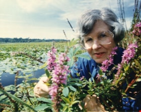
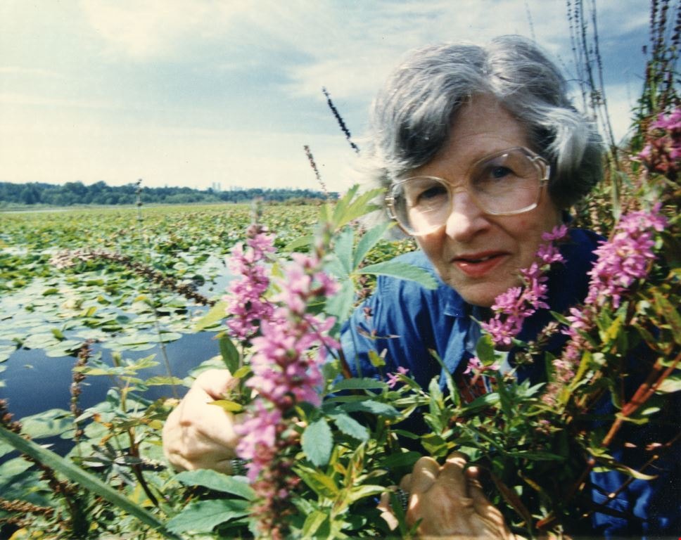
Doreen Lawson among purple loosestrife
https://search.heritageburnaby.ca/link/archivedescription91719
- Repository
- City of Burnaby Archives
- Date
- December 1992
- Collection/Fonds
- Doreen Lawson fonds
- Description Level
- Item
- Physical Description
- 1 photograph : col. ; 19 cm x 24 cm
- Scope and Content
- Photograph of Doreen Lawson posing with purple loosestrife plants with Burnaby Lake behind her.
- Repository
- City of Burnaby Archives
- Date
- December 1992
- Collection/Fonds
- Doreen Lawson fonds
- Physical Description
- 1 photograph : col. ; 19 cm x 24 cm
- Description Level
- Item
- Record No.
- 605-019
- Access Restriction
- No restrictions
- Reproduction Restriction
- Reproduce for fair dealing purposes only
- Accession Number
- 2003-30
- Scope and Content
- Photograph of Doreen Lawson posing with purple loosestrife plants with Burnaby Lake behind her.
- Names
- Lawson, Doreen A.
- Media Type
- Photograph
- Notes
- Title based on contents of photograph
- Note is grey ink on verso of photograph reads: "Dec. 92 / From Ethel Chernesky & Cam Avery"
- Stamp of verso of photograph reads: "The News / [address] / [phone]"
- Geographic Access
- Burnaby Lake
- Historic Neighbourhood
- Burnaby Lake (Historic Neighbourhood)
- Planning Study Area
- Burnaby Lake Area
Images
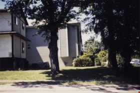
Looking west from Douglas Road
https://search.heritageburnaby.ca/link/archivedescription91833
- Repository
- City of Burnaby Archives
- Date
- 1991
- Collection/Fonds
- Small family fonds
- Description Level
- Item
- Physical Description
- 1 photograph : col. copy print ; 10 cm x 15 cm
- Scope and Content
- Photograph of the houses located on the corner of Douglas Road and Dominion Street, with large oak, hemlock, and fir trees in the yard. The house in the foreground is 3131 Douglas Road; the house in the background is 5536 Dominion Street. The photograph was taken from Douglas Street, looking west.
- Repository
- City of Burnaby Archives
- Date
- 1991
- Collection/Fonds
- Small family fonds
- Physical Description
- 1 photograph : col. copy print ; 10 cm x 15 cm
- Description Level
- Item
- Record No.
- 620-014
- Access Restriction
- No restrictions
- Reproduction Restriction
- No reproduction permitted
- Accession Number
- 2017-01
- Scope and Content
- Photograph of the houses located on the corner of Douglas Road and Dominion Street, with large oak, hemlock, and fir trees in the yard. The house in the foreground is 3131 Douglas Road; the house in the background is 5536 Dominion Street. The photograph was taken from Douglas Street, looking west.
- Media Type
- Photograph
- Notes
- Transcribed title
- Title transcribed from donor's notes
- Note in blue ink on verso of photograph reads: "Corner of Douglas Rd and Dominion St. with Oak Tree, Summer 1991"
- Note in blue ink on verso of photograph reads: "P14"
- 5118 Douglas Road renumbered to 3131 Douglas Road in 1958 and to 5538 Dominion Street in 1970 or 1971
- The oak tree (centre) is the same tree as in photograph 620-007
- Street Address
- 3131 Douglas Road
- 5118 Douglas Road
- 5538 Dominion Street
- Historic Neighbourhood
- Burnaby Lake (Historic Neighbourhood)
- Planning Study Area
- Ardingley-Sprott Area
Images

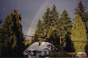
Looking north from south side of Dominion Street
https://search.heritageburnaby.ca/link/archivedescription91843
- Repository
- City of Burnaby Archives
- Date
- 1995
- Collection/Fonds
- Small family fonds
- Description Level
- Item
- Physical Description
- 1 photograph : col. ; 10 cm x 15 cm
- Scope and Content
- Photograph of a house located at 3093 Douglas Road surrounded by trees. A rainbow is visible through a break in the trees. The photograph was taken from the south side of Dominion Street, looking north.
- Repository
- City of Burnaby Archives
- Date
- 1995
- Collection/Fonds
- Small family fonds
- Physical Description
- 1 photograph : col. ; 10 cm x 15 cm
- Description Level
- Item
- Record No.
- 620-024
- Access Restriction
- No restrictions
- Reproduction Restriction
- No reproduction permitted
- Accession Number
- 2017-01
- Scope and Content
- Photograph of a house located at 3093 Douglas Road surrounded by trees. A rainbow is visible through a break in the trees. The photograph was taken from the south side of Dominion Street, looking north.
- Subjects
- Buildings - Residential - Houses
- Media Type
- Photograph
- Notes
- Transcribed title
- Title transcribed from donor's notes
- Note in black ink on verso of photograph reads: "Rainbow - Burnaby"
- Note in blue ink on verso of photograph reads: "P.24"
- Note in blue ink on verso of photograph reads: "1995 / 3093 Douglas Rd."
- Street Address
- 3093 Douglas Road
- Historic Neighbourhood
- Burnaby Lake (Historic Neighbourhood)
- Planning Study Area
- Ardingley-Sprott Area
Images

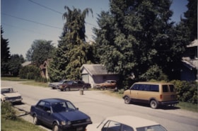
Looking northwest along Dominion Street from near Douglas Road
https://search.heritageburnaby.ca/link/archivedescription91845
- Repository
- City of Burnaby Archives
- Date
- 1991
- Collection/Fonds
- Small family fonds
- Description Level
- Item
- Physical Description
- 1 photograph : col. ; 10 cm x 15 cm
- Scope and Content
- Photograph of 5493 Dominion Street (left) and 3093 Douglas Road (right). Cars are parked on either side of the street and the houses are largely obscured by trees. The photograph was taken from Douglas Road, looking northwest along Dominion Street.
- Repository
- City of Burnaby Archives
- Date
- 1991
- Collection/Fonds
- Small family fonds
- Physical Description
- 1 photograph : col. ; 10 cm x 15 cm
- Description Level
- Item
- Record No.
- 620-026
- Access Restriction
- No restrictions
- Reproduction Restriction
- No reproduction permitted
- Accession Number
- 2017-01
- Scope and Content
- Photograph of 5493 Dominion Street (left) and 3093 Douglas Road (right). Cars are parked on either side of the street and the houses are largely obscured by trees. The photograph was taken from Douglas Road, looking northwest along Dominion Street.
- Subjects
- Buildings - Residential - Houses
- Media Type
- Photograph
- Notes
- Transcribed title
- Title transcribed from donor's notes
- Note in blue ink on verso of photograph reads: "P.26"
- Note in blue ink on verso of photograph reads: "N. Side of Dominion St. / Summer 1991"
- 5493 Dominion Street was previously numbered 3107 Dominion Street and was later subdivided into two lots: 5491 and 5495 Dominion Street.
- Street Address
- 3093 Douglas Road
- 5493 Dominion Street
- Historic Neighbourhood
- Burnaby Lake (Historic Neighbourhood)
- Planning Study Area
- Ardingley-Sprott Area
Images

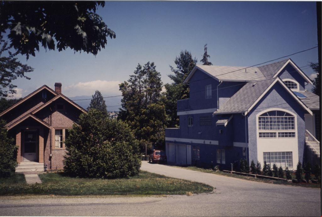
Looking north from 5486 Dominion Street
https://search.heritageburnaby.ca/link/archivedescription91853
- Repository
- City of Burnaby Archives
- Date
- 1991
- Collection/Fonds
- Small family fonds
- Description Level
- Item
- Physical Description
- 1 photograph : col. ; 10 cm x 15 cm
- Scope and Content
- Photograph of a single-storey brown stucco house located at 5495 Dominion Street and a three-storey blue stucco house at 5505 Dominion Street. The property at 3093 Douglas Road was subdivided and the blue house at 5505 Dominion Street was built. The photograph was taken from 5486 Dominion Street,…
- Repository
- City of Burnaby Archives
- Date
- 1991
- Collection/Fonds
- Small family fonds
- Physical Description
- 1 photograph : col. ; 10 cm x 15 cm
- Description Level
- Item
- Record No.
- 620-034
- Access Restriction
- No restrictions
- Reproduction Restriction
- No reproduction permitted
- Accession Number
- 2017-01
- Scope and Content
- Photograph of a single-storey brown stucco house located at 5495 Dominion Street and a three-storey blue stucco house at 5505 Dominion Street. The property at 3093 Douglas Road was subdivided and the blue house at 5505 Dominion Street was built. The photograph was taken from 5486 Dominion Street, looking north.
- Subjects
- Buildings - Residential - Houses
- Media Type
- Photograph
- Notes
- Transcribed title
- Title transcribed from donor's notes
- Note in blue ink on verso of photograph reads: "P.34"
- Note in blue ink on verso of photograph reads: "Looking North from Dominion St. by "side lane" / MacFaydens House Kit Brocklebank's house / Summer 1991"
- 5118 Douglas Road renumbered to 3131 Douglas Road in 1958 and to 5538 Dominion Street in 1970 or 1971
- Street Address
- 5505 Dominion Street
- 5495 Dominion Street
- Historic Neighbourhood
- Burnaby Lake (Historic Neighbourhood)
- Planning Study Area
- Ardingley-Sprott Area
Images
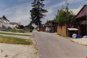
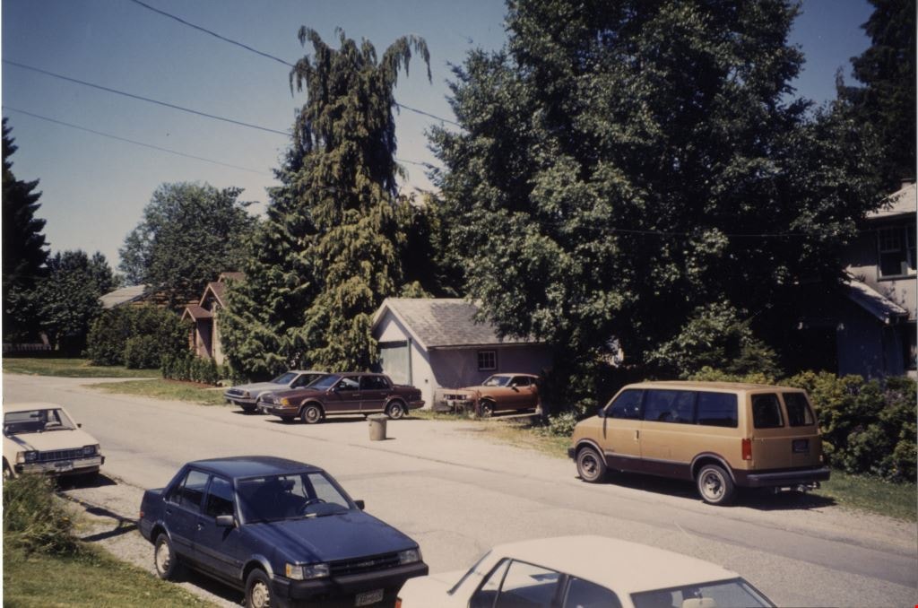
Looking west along the back lane
https://search.heritageburnaby.ca/link/archivedescription91860
- Repository
- City of Burnaby Archives
- Date
- June 1994
- Collection/Fonds
- Small family fonds
- Description Level
- Item
- Physical Description
- 1 photograph : col. copy print ; 10 cm x 15 cm
- Scope and Content
- Photograph of the back lane between Dominion Street and Norfolk Street, looking west. The fir tree in the centre of the photograph is one of many planted by John Roberts along the south property line of 5538 Dominion Street. The other trees were removed in 1982 when the Roberts' property was larg…
- Repository
- City of Burnaby Archives
- Date
- June 1994
- Collection/Fonds
- Small family fonds
- Physical Description
- 1 photograph : col. copy print ; 10 cm x 15 cm
- Description Level
- Item
- Record No.
- 620-041
- Access Restriction
- No restrictions
- Reproduction Restriction
- No reproduction permitted
- Accession Number
- 2017-01
- Scope and Content
- Photograph of the back lane between Dominion Street and Norfolk Street, looking west. The fir tree in the centre of the photograph is one of many planted by John Roberts along the south property line of 5538 Dominion Street. The other trees were removed in 1982 when the Roberts' property was largely cleared in order to relocate the house 100 feet west and subdivide the property into 33 foot lots.
- Subjects
- Geographic Features - Lanes
- Media Type
- Photograph
- Notes
- Transcribed title
- Title transcribed from donor's notes
- Note in blue ink on verso of photograph reads: "P.4"
- Note in blue ink on verso of photograph reads: "The Back lane behind 3131 Douglas Rd to 5496 etc Dominion St. / June 1994"
- 5118 Douglas Road renumbered to 3131 Douglas Road in 1958 and to 5538 Dominion Street in 1970 or 1971
- Street Address
- 3131 Douglas Road
- 5118 Douglas Road
- 5538 Dominion Street
- Historic Neighbourhood
- Burnaby Lake (Historic Neighbourhood)
- Planning Study Area
- Ardingley-Sprott Area
Images

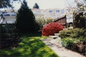
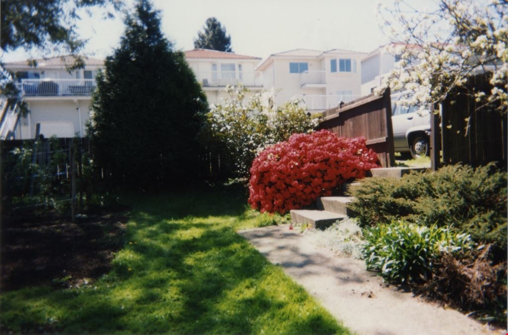
Looking south from 5496 Dominion Street
https://search.heritageburnaby.ca/link/archivedescription91865
- Repository
- City of Burnaby Archives
- Date
- April 1998
- Collection/Fonds
- Small family fonds
- Description Level
- Item
- Physical Description
- 1 photograph : col. ; 10 cm x 15 cm
- Scope and Content
- Photograph of the backyard at 5496 Dominion Street, looking south with the houses on Norfolk Street visible above the fence. These houses were built in the 1980s and 1990s following the rezoning of the properties.
- Repository
- City of Burnaby Archives
- Date
- April 1998
- Collection/Fonds
- Small family fonds
- Physical Description
- 1 photograph : col. ; 10 cm x 15 cm
- Description Level
- Item
- Record No.
- 620-046
- Access Restriction
- No restrictions
- Reproduction Restriction
- No reproduction permitted
- Accession Number
- 2017-01
- Scope and Content
- Photograph of the backyard at 5496 Dominion Street, looking south with the houses on Norfolk Street visible above the fence. These houses were built in the 1980s and 1990s following the rezoning of the properties.
- Media Type
- Photograph
- Notes
- Transcribed title
- Title transcribed from donor's notes
- Note in blue ink on verso of photograph reads: "P9"
- Note in black ink on verso of photograph reads: "April 1998 / 5496 Dominion St"
- Geographic Access
- Norfolk Street
- Street Address
- 5496 Dominion Street
- Historic Neighbourhood
- Burnaby Lake (Historic Neighbourhood)
- Planning Study Area
- Ardingley-Sprott Area
Images