Narrow Results By
4250 Grange St
https://search.heritageburnaby.ca/link/archivedescription93892
- Repository
- City of Burnaby Archives
- Date
- June 1993
- Collection/Fonds
- Grover, Elliott & Co. Ltd. fonds
- Description Level
- File
- Physical Description
- 25 photographs : col. negatives ; 35 mm
- Scope and Content
- Photographs of an undeveloped property located at 4250 Grange Street - an address that no longer exists. The property's current address is 5833 Wilson Avenue. A billboard in front of the property reads: Paramount / Coming Soon / Two 21-Storey Luxury Twin Towers".
- Repository
- City of Burnaby Archives
- Date
- June 1993
- Collection/Fonds
- Grover, Elliott & Co. Ltd. fonds
- Physical Description
- 25 photographs : col. negatives ; 35 mm
- Description Level
- File
- Record No.
- 622-075
- Access Restriction
- No restrictions
- Reproduction Restriction
- No restrictions
- Accession Number
- 2017-39
- Scope and Content
- Photographs of an undeveloped property located at 4250 Grange Street - an address that no longer exists. The property's current address is 5833 Wilson Avenue. A billboard in front of the property reads: Paramount / Coming Soon / Two 21-Storey Luxury Twin Towers".
- Media Type
- Photograph
- Notes
- Transcribed title
- Title transcribed from envelope photographs were originally housed in
- File no. 93-284-B
- Photographer identified as "J.C."
- Geographic Access
- Wilson Avenue
- Grange Street
- Street Address
- 5833 Wilson Avenue
- Historic Neighbourhood
- Central Park (Historic Neighbourhood)
- Planning Study Area
- Garden Village Area
5744 Byrne Rd
https://search.heritageburnaby.ca/link/archivedescription94345
- Repository
- City of Burnaby Archives
- Date
- January 1993
- Collection/Fonds
- Grover, Elliott & Co. Ltd. fonds
- Description Level
- File
- Physical Description
- 51 photographs : col. negatives ; 35 mm
- Scope and Content
- Photographs of commercial and undeveloped properties located in the Big Bend area, including 5744 Byrne Road, Lowland Drive, and 4853 Byrne Road.
- Repository
- City of Burnaby Archives
- Date
- January 1993
- Collection/Fonds
- Grover, Elliott & Co. Ltd. fonds
- Physical Description
- 51 photographs : col. negatives ; 35 mm
- Description Level
- File
- Record No.
- 622-130
- Access Restriction
- No restrictions
- Reproduction Restriction
- No restrictions
- Accession Number
- 2017-39
- Scope and Content
- Photographs of commercial and undeveloped properties located in the Big Bend area, including 5744 Byrne Road, Lowland Drive, and 4853 Byrne Road.
- Media Type
- Photograph
- Notes
- Transcribed title
- Title transcribed from envelope photographs were originally housed in
- File no. 95-285-B
- Sticky note adhered to print of photograph 622-130-036 reads: "Lowland Drive"
- Sticky note adhered to print of photograph 622-130-039 reads: "4853 Byrne"
- Photographer identified as "L.D."
- Geographic Access
- Byrne Road
- Lowland Drive
- Street Address
- 5744 Byrne Road
- 4853 Byrne Road
- Historic Neighbourhood
- Fraser Arm (Historic Neighbourhood)
- Planning Study Area
- Big Bend Area

Deer Lake
https://search.heritageburnaby.ca/link/archivedescription91707
- Repository
- City of Burnaby Archives
- Date
- 1994-1996
- Collection/Fonds
- Doreen Lawson fonds
- Description Level
- File
- Physical Description
- 55 photographs : col. slides ; 35 mm
- Scope and Content
- File consists of scenic photographs of Deer Lake and Deer Lake Park, including closeup photographs of the lake and landscape photographs with the lake in the foreground and mountains and skyline visible in the distance. The photographs capture Deer Lake in the fall, winter, and spring. Also inclu…
- Repository
- City of Burnaby Archives
- Date
- 1994-1996
- Collection/Fonds
- Doreen Lawson fonds
- Physical Description
- 55 photographs : col. slides ; 35 mm
- Description Level
- File
- Record No.
- 618-025
- Access Restriction
- No restrictions
- Reproduction Restriction
- No restrictions
- Accession Number
- 2015-15
- Scope and Content
- File consists of scenic photographs of Deer Lake and Deer Lake Park, including closeup photographs of the lake and landscape photographs with the lake in the foreground and mountains and skyline visible in the distance. The photographs capture Deer Lake in the fall, winter, and spring. Also included in the file are four photographs of Deer Lake Park signs.
- Subjects
- Natural Phenomena - Snow
- Geographic Features - Lakes and Ponds
- Plants - Trees
- Geographic Features - Mountains
- Advertising Medium - Signs and Signboards
- Names
- Burnaby Art Gallery
- Media Type
- Photograph
- Photographer
- Lawson, Doreen A.
- Notes
- Title based on contents of photographs
- Geographic Access
- Deer Lake
- Historic Neighbourhood
- Burnaby Lake (Historic Neighbourhood)
- Planning Study Area
- Oakalla Area
Images

Southern Railway of BC Burnaby
https://search.heritageburnaby.ca/link/archivedescription94306
- Repository
- City of Burnaby Archives
- Date
- February 1994
- Collection/Fonds
- Grover, Elliott & Co. Ltd. fonds
- Description Level
- File
- Physical Description
- 16 photographs : col. negatives ; 35 mm + 1 computer disk ; 14 x 14 cm
- Scope and Content
- Photographs of properties owned by Scott Paper Ltd, including the Doman Sawmill property. Several of the photographs include zoning signs notifying the public that the property is to be developed or redeveloped for Heavy Industrial permitted use.
- Repository
- City of Burnaby Archives
- Date
- February 1994
- Collection/Fonds
- Grover, Elliott & Co. Ltd. fonds
- Physical Description
- 16 photographs : col. negatives ; 35 mm + 1 computer disk ; 14 x 14 cm
- Description Level
- File
- Record No.
- 622-091
- Access Restriction
- No restrictions
- Reproduction Restriction
- No restrictions
- Accession Number
- 2017-39
- Scope and Content
- Photographs of properties owned by Scott Paper Ltd, including the Doman Sawmill property. Several of the photographs include zoning signs notifying the public that the property is to be developed or redeveloped for Heavy Industrial permitted use.
- Subjects
- Buildings - Industrial
- Buildings - Industrial - Mills
- Advertising Medium - Signs and Signboards
- Media Type
- Photograph
- Photographer
- Young, Richard
- Notes
- Transcribed title
- Title transcribed from envelope photographs were originally housed in
- File no. 94-100-O
- Computer disk labelled "Railands.xsl / 2/93"
8980 Fraserwood Crt
https://search.heritageburnaby.ca/link/archivedescription94326
- Repository
- City of Burnaby Archives
- Date
- December 1994
- Collection/Fonds
- Grover, Elliott & Co. Ltd. fonds
- Description Level
- File
- Physical Description
- 24 photographs : col. negatives ; 35 mm
- Scope and Content
- Photographs of an undeveloped property located at 8980 Fraserwood Court. A Sutton Group real estate sign on the property advertises the site as the Fraserwood Corporate Centre with strata warehouse and office flex space. File also contains photographs of the commerical building adjacent to the si…
- Repository
- City of Burnaby Archives
- Date
- December 1994
- Collection/Fonds
- Grover, Elliott & Co. Ltd. fonds
- Physical Description
- 24 photographs : col. negatives ; 35 mm
- Description Level
- File
- Record No.
- 622-111
- Access Restriction
- No restrictions
- Reproduction Restriction
- No restrictions
- Accession Number
- 2017-39
- Scope and Content
- Photographs of an undeveloped property located at 8980 Fraserwood Court. A Sutton Group real estate sign on the property advertises the site as the Fraserwood Corporate Centre with strata warehouse and office flex space. File also contains photographs of the commerical building adjacent to the site.
- Media Type
- Photograph
- Notes
- Transcribed title
- Title transcribed from envelope photographs were originally housed in
- File no. 94-422-B
- Photographer identified as "L.D."
- Geographic Access
- Fraserwood Court
- Street Address
- 8980 Fraserwood Court
- Historic Neighbourhood
- Fraser Arm (Historic Neighbourhood)
- Planning Study Area
- Big Bend Area
1160 Douglas Rd
https://search.heritageburnaby.ca/link/archivedescription94327
- Repository
- City of Burnaby Archives
- Date
- December 1994
- Collection/Fonds
- Grover, Elliott & Co. Ltd. fonds
- Description Level
- File
- Physical Description
- 22 photographs : col. negatives ; 35 mm
- Scope and Content
- Photographs of the exterior of a three-storey commerical building located at 1160 Douglas Road.
- Repository
- City of Burnaby Archives
- Date
- December 1994
- Collection/Fonds
- Grover, Elliott & Co. Ltd. fonds
- Physical Description
- 22 photographs : col. negatives ; 35 mm
- Description Level
- File
- Record No.
- 622-112
- Access Restriction
- No restrictions
- Reproduction Restriction
- No restrictions
- Accession Number
- 2017-39
- Scope and Content
- Photographs of the exterior of a three-storey commerical building located at 1160 Douglas Road.
- Media Type
- Photograph
- Photographer
- Young, Richard
- Notes
- Transcribed title
- Title transcribed from envelope photographs were originally housed in
- File no. 94-424-B
- Geographic Access
- Douglas Road
- Street Address
- 1160 Douglas Road
- Historic Neighbourhood
- Vancouver Heights (Historic Neighbourhood)
- Planning Study Area
- Willingdon Heights Area
2761 North Rd
https://search.heritageburnaby.ca/link/archivedescription94334
- Repository
- City of Burnaby Archives
- Date
- April 1995
- Collection/Fonds
- Grover, Elliott & Co. Ltd. fonds
- Description Level
- File
- Physical Description
- 24 photographs : col. negatives ; 35 mm
- Scope and Content
- Photographs of an undeveloped property located at 2761 North Road - an address that no longer exists. Three large billboards are posted at the edge of the property, facing onto the street.
- Repository
- City of Burnaby Archives
- Date
- April 1995
- Collection/Fonds
- Grover, Elliott & Co. Ltd. fonds
- Physical Description
- 24 photographs : col. negatives ; 35 mm
- Description Level
- File
- Record No.
- 622-119
- Access Restriction
- No restrictions
- Reproduction Restriction
- No restrictions
- Accession Number
- 2017-39
- Scope and Content
- Photographs of an undeveloped property located at 2761 North Road - an address that no longer exists. Three large billboards are posted at the edge of the property, facing onto the street.
- Media Type
- Photograph
- Photographer
- Young, Richard
- Notes
- Transcribed title
- Title transcribed from envelope photographs were originally housed in
- File no. 95-167-B
- Geographic Access
- North Road
- Historic Neighbourhood
- Burquitlam (Historic Neighbourhood)
- Planning Study Area
- Lyndhurst Area
![Second Street School banners, [1999] thumbnail](/media/hpo/_Data/_Archives_Images/_Unrestricted/535/535-3247.jpg?width=280)
Second Street School banners
https://search.heritageburnaby.ca/link/archivedescription98169
- Repository
- City of Burnaby Archives
- Date
- [1999]
- Collection/Fonds
- Burnaby NewsLeader photograph collection
- Description Level
- Item
- Physical Description
- 1 photograph (tiff) : col.
- Scope and Content
- Photograph of an Brian Sarginson, of the City of Burnaby Engineering Department, installing banners depicting birds and a growing garden on a streetlight by Second Street School. The banners were painted by students and local artist Joanne Folks.
- Repository
- City of Burnaby Archives
- Date
- [1999]
- Collection/Fonds
- Burnaby NewsLeader photograph collection
- Physical Description
- 1 photograph (tiff) : col.
- Description Level
- Item
- Record No.
- 535-3247
- Access Restriction
- No restrictions
- Reproduction Restriction
- No restrictions
- Accession Number
- 2018-12
- Scope and Content
- Photograph of an Brian Sarginson, of the City of Burnaby Engineering Department, installing banners depicting birds and a growing garden on a streetlight by Second Street School. The banners were painted by students and local artist Joanne Folks.
- Names
- Second Street School
- Media Type
- Photograph
- Photographer
- Bartel, Mario
- Notes
- Title based on caption
- Collected by editorial for use in a July 1999 issue of the Burnaby NewsLeader
- Caption from metadata: "Brian Sarginson, of Burnaby's Engineering Department, hangs some of the eight banners designed and painted by students at Second Ave. Community School, with a little guidance from local artist, Joanne Folks."
- Geographic Access
- 2nd Street
- Street Address
- 7502 2nd Street
- Historic Neighbourhood
- East Burnaby (Historic Neighbourhood)
- Planning Study Area
- Second Street Area
Images
![Second Street School banners, [1999] thumbnail](/media/hpo/_Data/_Archives_Images/_Unrestricted/535/535-3247.jpg)

Do Your Part Eagle
https://search.heritageburnaby.ca/link/archivedescription95084
- Repository
- City of Burnaby Archives
- Date
- June 13, 2020
- Collection/Fonds
- Burnaby Photographic Society fonds
- Description Level
- Item
- Physical Description
- 1 photograph (tiff)
- Scope and Content
- Photograph of a sign along the Burnaby Lake Freeway Trail that reads: "Do your part. Stay 2 metres apart." The sign has a silhoutte drawing of an eagle with its wings open to illustrate the distance of two metres.
- Repository
- City of Burnaby Archives
- Date
- June 13, 2020
- Collection/Fonds
- Burnaby Photographic Society fonds
- Physical Description
- 1 photograph (tiff)
- Description Level
- Item
- Record No.
- 623-003
- Access Restriction
- No restrictions
- Reproduction Restriction
- No restrictions
- Accession Number
- 2020-10
- Scope and Content
- Photograph of a sign along the Burnaby Lake Freeway Trail that reads: "Do your part. Stay 2 metres apart." The sign has a silhoutte drawing of an eagle with its wings open to illustrate the distance of two metres.
- Media Type
- Photograph
- Photographer
- Gervan, Bonnie
- Notes
- Transcribed title
- Photographer's caption: "A sign shows how far to keep apart."
- Geographic Access
- Burnaby Lake Regional Nature Park
- Historic Neighbourhood
- Burnaby Lake (Historic Neighbourhood)
- Planning Study Area
- Burnaby Lake Area
Images

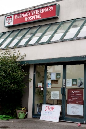
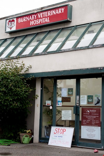
Vet Hospital
https://search.heritageburnaby.ca/link/archivedescription95086
- Repository
- City of Burnaby Archives
- Date
- June 13, 2020
- Collection/Fonds
- Burnaby Photographic Society fonds
- Description Level
- Item
- Physical Description
- 1 photograph (tiff)
- Scope and Content
- Photograph of the exterior of the Burnaby Veterinarian Hospital. A whiteboard is propped up against the door of the hospital with a notice prohibiting visitors from entering and requesting they call for entry.
- Repository
- City of Burnaby Archives
- Date
- June 13, 2020
- Collection/Fonds
- Burnaby Photographic Society fonds
- Physical Description
- 1 photograph (tiff)
- Description Level
- Item
- Record No.
- 623-005
- Access Restriction
- No restrictions
- Reproduction Restriction
- No restrictions
- Accession Number
- 2020-10
- Scope and Content
- Photograph of the exterior of the Burnaby Veterinarian Hospital. A whiteboard is propped up against the door of the hospital with a notice prohibiting visitors from entering and requesting they call for entry.
- Media Type
- Photograph
- Photographer
- Gervan, Bonnie
- Notes
- Transcribed title
- Photographer's caption: "Sign says “Stop, No Entry, Please Call”. Staff will come out to accept the non human clients outside and bring them in for their appointment."
- Geographic Access
- Springer Avenue
- Street Address
- 2210 Springer Avenue
- Planning Study Area
- Ardingley-Sprott Area
Images

Cheap Gas during Covid Pandemic
https://search.heritageburnaby.ca/link/archivedescription95087
- Repository
- City of Burnaby Archives
- Date
- April 27, 2020
- Collection/Fonds
- Burnaby Photographic Society fonds
- Description Level
- Item
- Physical Description
- 1 photograph (tiff)
- Scope and Content
- Photograph of a Chevron Gas Station sign advertising gas for 85.9 cents per litre. The Chevron station is located at 6138 Kingsway.
- Repository
- City of Burnaby Archives
- Date
- April 27, 2020
- Collection/Fonds
- Burnaby Photographic Society fonds
- Physical Description
- 1 photograph (tiff)
- Description Level
- Item
- Record No.
- 623-006
- Access Restriction
- No restrictions
- Reproduction Restriction
- Reproduce for fair dealing purposes only
- Accession Number
- 2020-10
- Scope and Content
- Photograph of a Chevron Gas Station sign advertising gas for 85.9 cents per litre. The Chevron station is located at 6138 Kingsway.
- Media Type
- Photograph
- Photographer
- Asbia, Cher
- Notes
- Transcribed title
- Photographer's caption: "Huge drop in gas prices for a few weeks only"
- Geographic Access
- Kingsway
- Street Address
- 6138 Kingsway
- Planning Study Area
- Clinton-Glenwood Area
Images


Social distance in Burnaby Parks
https://search.heritageburnaby.ca/link/archivedescription95093
- Repository
- City of Burnaby Archives
- Date
- May 8, 2020
- Collection/Fonds
- Burnaby Photographic Society fonds
- Description Level
- Item
- Physical Description
- 1 photograph (tiff)
- Scope and Content
- Photograph of a City of Burnaby sign encouraging social distancing attached to a tree in Mary Avenue Park.
- Repository
- City of Burnaby Archives
- Date
- May 8, 2020
- Collection/Fonds
- Burnaby Photographic Society fonds
- Physical Description
- 1 photograph (tiff)
- Description Level
- Item
- Record No.
- 623-012
- Access Restriction
- No restrictions
- Reproduction Restriction
- Reproduce for fair dealing purposes only
- Accession Number
- 2020-10
- Scope and Content
- Photograph of a City of Burnaby sign encouraging social distancing attached to a tree in Mary Avenue Park.
- Media Type
- Photograph
- Photographer
- Asbia, Cher
- Notes
- Transcribed title
- Geographic Access
- 12th Avenue
- Historic Neighbourhood
- Edmonds (Historic Neighbourhood)
- Planning Study Area
- Edmonds Area
Images


Burnaby hospital closes main entrance
https://search.heritageburnaby.ca/link/archivedescription95094
- Repository
- City of Burnaby Archives
- Date
- April 6, 2020
- Collection/Fonds
- Burnaby Photographic Society fonds
- Description Level
- Item
- Physical Description
- 1 photograph (tiff)
- Scope and Content
- Photograph of a rerouting sign posted to a sandwich board outside the Burnaby Hospital emergency lot. The sign states that the hospital entrance is closed and requests visitors use the Main Entrance of the hospital.
- Repository
- City of Burnaby Archives
- Date
- April 6, 2020
- Collection/Fonds
- Burnaby Photographic Society fonds
- Physical Description
- 1 photograph (tiff)
- Description Level
- Item
- Record No.
- 623-013
- Access Restriction
- No restrictions
- Reproduction Restriction
- No restrictions
- Accession Number
- 2020-10
- Scope and Content
- Photograph of a rerouting sign posted to a sandwich board outside the Burnaby Hospital emergency lot. The sign states that the hospital entrance is closed and requests visitors use the Main Entrance of the hospital.
- Subjects
- Buildings - Civic - Hospitals
- Geographic Features - Automobile Parking Lots
- Advertising Medium - Signs and Signboards
- Media Type
- Photograph
- Photographer
- Damer, Eric
- Notes
- Transcribed title
- Geographic Access
- Kincaid Street
- Street Address
- 3935 Kincaid Street
- Historic Neighbourhood
- Broadview (Historic Neighbourhood)
- Planning Study Area
- Cascade-Schou Area
Images


New regulations at work site
https://search.heritageburnaby.ca/link/archivedescription95095
- Repository
- City of Burnaby Archives
- Date
- April 16, 2020
- Collection/Fonds
- Burnaby Photographic Society fonds
- Description Level
- Item
- Physical Description
- 1 photograph (tiff)
- Scope and Content
- Photograph of signs attached to security fencing outside the closed Schou Education Centre on Canada Way. Signs are handwritten and contain COVID-19 site safety protocols. Photograph was taken from Norfolk Street, facing south.
- Repository
- City of Burnaby Archives
- Date
- April 16, 2020
- Collection/Fonds
- Burnaby Photographic Society fonds
- Physical Description
- 1 photograph (tiff)
- Description Level
- Item
- Record No.
- 623-014
- Access Restriction
- No restrictions
- Reproduction Restriction
- No restrictions
- Accession Number
- 2020-10
- Scope and Content
- Photograph of signs attached to security fencing outside the closed Schou Education Centre on Canada Way. Signs are handwritten and contain COVID-19 site safety protocols. Photograph was taken from Norfolk Street, facing south.
- Media Type
- Photograph
- Photographer
- Damer, Eric
- Notes
- Transcribed title
- Geographic Access
- Gilmore Avenue
- Canada Way
- Street Address
- 4054 Norfolk Street
- Historic Neighbourhood
- Broadview (Historic Neighbourhood)
- Planning Study Area
- Cascade-Schou Area
Images


Swangard Stadium closed
https://search.heritageburnaby.ca/link/archivedescription95096
- Repository
- City of Burnaby Archives
- Date
- April 21, 2020
- Collection/Fonds
- Burnaby Photographic Society fonds
- Description Level
- Item
- Physical Description
- 1 photograph (tiff)
- Scope and Content
- Photograph of two City of Burnaby signs attached to fencing outside Swangard Stadium in Central Park. The signs announce the facility's closure in response to the COVID-19 pandemic. Behind the fencing, the stadium's track and bleachers are visible.
- Repository
- City of Burnaby Archives
- Date
- April 21, 2020
- Collection/Fonds
- Burnaby Photographic Society fonds
- Physical Description
- 1 photograph (tiff)
- Description Level
- Item
- Record No.
- 623-015
- Access Restriction
- No restrictions
- Reproduction Restriction
- No restrictions
- Accession Number
- 2020-10
- Scope and Content
- Photograph of two City of Burnaby signs attached to fencing outside Swangard Stadium in Central Park. The signs announce the facility's closure in response to the COVID-19 pandemic. Behind the fencing, the stadium's track and bleachers are visible.
- Names
- Swangard Stadium
- Media Type
- Photograph
- Photographer
- Damer, Eric
- Notes
- Transcribed title
- Geographic Access
- Central Park
- Imperial Street
- Street Address
- 3883 Imperial Street
- Historic Neighbourhood
- Central Park (Historic Neighbourhood)
- Planning Study Area
- Maywood Area
Images


Radical sentiments
https://search.heritageburnaby.ca/link/archivedescription95098
- Repository
- City of Burnaby Archives
- Date
- April 29, 2020
- Collection/Fonds
- Burnaby Photographic Society fonds
- Description Level
- Item
- Physical Description
- 1 photograph (tiff)
- Scope and Content
- Photograph of a Socialist Alternative "Fight Coronavirus & Fight Capitalism" sign posted to a telephone poll near the BCIT campus.
- Repository
- City of Burnaby Archives
- Date
- April 29, 2020
- Collection/Fonds
- Burnaby Photographic Society fonds
- Physical Description
- 1 photograph (tiff)
- Description Level
- Item
- Record No.
- 623-017
- Access Restriction
- No restrictions
- Reproduction Restriction
- No restrictions
- Accession Number
- 2020-10
- Scope and Content
- Photograph of a Socialist Alternative "Fight Coronavirus & Fight Capitalism" sign posted to a telephone poll near the BCIT campus.
- Media Type
- Photograph
- Photographer
- Damer, Eric
- Notes
- Transcribed title
- Geographic Access
- Willingdon Avenue
- Sanderson Way
- Planning Study Area
- Cascade-Schou Area
Images


Hopeful sign on Smith Ave
https://search.heritageburnaby.ca/link/archivedescription95099
- Repository
- City of Burnaby Archives
- Date
- March 21, 2020
- Collection/Fonds
- Burnaby Photographic Society fonds
- Description Level
- Item
- Physical Description
- 1 photograph (tiff)
- Scope and Content
- Photograph of a bright pink sign stapled to a telphone poll on Smith Avenue near Wakefield Court. A smiling green creature is painted on the sign along with the message "Stay Happy Stay Healthy!".
- Repository
- City of Burnaby Archives
- Date
- March 21, 2020
- Collection/Fonds
- Burnaby Photographic Society fonds
- Physical Description
- 1 photograph (tiff)
- Description Level
- Item
- Record No.
- 623-018
- Access Restriction
- No restrictions
- Reproduction Restriction
- No restrictions
- Accession Number
- 2020-10
- Scope and Content
- Photograph of a bright pink sign stapled to a telphone poll on Smith Avenue near Wakefield Court. A smiling green creature is painted on the sign along with the message "Stay Happy Stay Healthy!".
- Media Type
- Photograph
- Photographer
- Damer, Eric
- Notes
- Transcribed title
- Geographic Access
- Smith Avenue
- Planning Study Area
- Cascade-Schou Area
Images


Central Park testing station
https://search.heritageburnaby.ca/link/archivedescription95101
- Repository
- City of Burnaby Archives
- Date
- May 9, 2020
- Collection/Fonds
- Burnaby Photographic Society fonds
- Description Level
- Item
- Physical Description
- 1 photograph (tiff)
- Scope and Content
- Photograph of the COVID-19 testing station located in the Central Park parking lot off Boundary Road. A sign in the foreground reads "Covid-19 Care Site by Referral Only / Walk in Access". In the background, the white tents of the testing station are visible.
- Repository
- City of Burnaby Archives
- Date
- May 9, 2020
- Collection/Fonds
- Burnaby Photographic Society fonds
- Physical Description
- 1 photograph (tiff)
- Description Level
- Item
- Record No.
- 623-019
- Access Restriction
- No restrictions
- Reproduction Restriction
- No restrictions
- Accession Number
- 2020-10
- Scope and Content
- Photograph of the COVID-19 testing station located in the Central Park parking lot off Boundary Road. A sign in the foreground reads "Covid-19 Care Site by Referral Only / Walk in Access". In the background, the white tents of the testing station are visible.
- Subjects
- Geographic Features - Parks
- Geographic Features - Automobile Parking Lots
- Advertising Medium - Signs and Signboards
- Structures - Tents
- Media Type
- Photograph
- Photographer
- Damer, Eric
- Notes
- Transcribed title
- Geographic Access
- Boundary Road
- Central Park
- Historic Neighbourhood
- Central Park (Historic Neighbourhood)
- Planning Study Area
- Maywood Area
Images


Confederation park playground closure
https://search.heritageburnaby.ca/link/archivedescription95102
- Repository
- City of Burnaby Archives
- Date
- April 29, 2020
- Collection/Fonds
- Burnaby Photographic Society fonds
- Description Level
- Item
- Physical Description
- 1 photograph (tiff)
- Scope and Content
- Photograph of a City of Burnaby facility closure sign at Confederation Park. Sign is attached to security fencing closing off the playground equipment at the park.
- Repository
- City of Burnaby Archives
- Date
- April 29, 2020
- Collection/Fonds
- Burnaby Photographic Society fonds
- Physical Description
- 1 photograph (tiff)
- Description Level
- Item
- Record No.
- 623-020
- Access Restriction
- No restrictions
- Reproduction Restriction
- No restrictions
- Accession Number
- 2020-10
- Scope and Content
- Photograph of a City of Burnaby facility closure sign at Confederation Park. Sign is attached to security fencing closing off the playground equipment at the park.
- Media Type
- Photograph
- Photographer
- King, Gloria
- Notes
- Transcribed title
- Geographic Access
- Albert Street
- Confederation Park
- Planning Study Area
- Capitol Hill Area
Images


Dr. Bonny Henry’s mantra, Burnaby North Sec School
https://search.heritageburnaby.ca/link/archivedescription95103
- Repository
- City of Burnaby Archives
- Date
- April 30, 2020
- Collection/Fonds
- Burnaby Photographic Society fonds
- Description Level
- Item
- Physical Description
- 1 photograph (tiff)
- Scope and Content
- Photograph of a man standing beside a marquee at Burnaby North Secondary School that reads "Be Kind Be Calm Be Safe". The man is wearing a yellow baseball hat, respirator mask, and white latex gloves.
- Repository
- City of Burnaby Archives
- Date
- April 30, 2020
- Collection/Fonds
- Burnaby Photographic Society fonds
- Physical Description
- 1 photograph (tiff)
- Description Level
- Item
- Record No.
- 623-021
- Access Restriction
- No restrictions
- Reproduction Restriction
- No restrictions
- Accession Number
- 2020-10
- Scope and Content
- Photograph of a man standing beside a marquee at Burnaby North Secondary School that reads "Be Kind Be Calm Be Safe". The man is wearing a yellow baseball hat, respirator mask, and white latex gloves.
- Media Type
- Photograph
- Photographer
- King, Gloria
- Notes
- Transcribed title
- Photographer's caption: "Burnaby North Sec School-Quote from Dr. Bonnie Henry"
- Geographic Access
- Hammarskjold Drive
- Street Address
- 751 Hammarskjold Drive
- Planning Study Area
- Parkcrest-Aubrey Area
Images
