Narrow Results By
Subject
- Advertising Medium - Signs and Signboards 1
- Agriculture - Farms 2
- Agriculture - Fruit and Berries 2
- Agriculture - Orchards 1
- Buildings - Agricultural - Barns 1
- Buildings - Civic - Hospitals 1
- Buildings - Civic - Libraries 1
- Buildings - Commercial - Train Stations 1
- Buildings - Heritage 4
- Buildings - Recreational 4
- Buildings - Religious - Churches 9
- Buildings - Residential - Houses 14

Charles R. Shaw House
https://search.heritageburnaby.ca/link/landmark525
- Repository
- Burnaby Heritage Planning
- Description
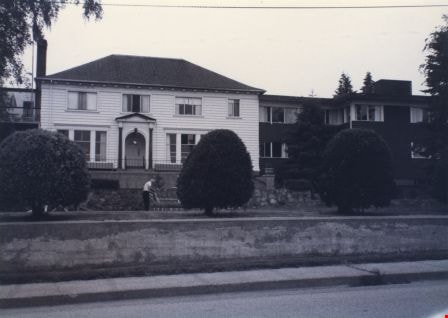
- The Charles R. Shaw House is a one and one-half storey plus basement wood-frame late Victorian era residence, located on the grounds of the Normanna Rest Home development in East Burnaby, near its original location on this site. Originally a modest vernacular Victorian structure, it has been enlarg…
- Associated Dates
- 1891
- Formal Recognition
- Heritage Designation, Community Heritage Register
- Other Names
- Charles R. & Mary Shaw House
- Street View URL
- Google Maps Street View
- Repository
- Burnaby Heritage Planning
- Other Names
- Charles R. & Mary Shaw House
- Geographic Access
- 12th Avenue
- 4th Street
- 13th Avenue
- Associated Dates
- 1891
- Formal Recognition
- Heritage Designation, Community Heritage Register
- Enactment Type
- Bylaw No. 10739
- Enactment Date
- 06/04/1998
- Description
- The Charles R. Shaw House is a one and one-half storey plus basement wood-frame late Victorian era residence, located on the grounds of the Normanna Rest Home development in East Burnaby, near its original location on this site. Originally a modest vernacular Victorian structure, it has been enlarged and embellished through later additions.
- Heritage Value
- The Shaw House is one of the oldest surviving houses in Burnaby, and is valued as a representation of a typical vernacular pioneer house in Burnaby, and a rare survivor from the late Victorian era. The original portion of the house displays a simplicity of form and detail consistent with early local construction, while the later additions display a more sophisticated approach. Originally built in 1891, this house is valued for its association with first owner, Charles R. Shaw (1834-1916) and Mary D. Shaw (1848-1897), one of Burnaby’s earliest settlers. Born in England, Shaw immigrated to Toronto in 1869, and relocated to New Westminster in 1889, where he worked as an employee of the Mechanic's Mill Company, an early woodworking plant. After moving to Burnaby, he was unanimously elected by acclamation as first reeve (mayor) of the new municipality in 1892. In 1894, Shaw sold his house and farm and moved his family to Kamloops due to his wife Mary's failing health. After Mary died in 1897, the Shaw family returned to Toronto. The Shaw House is additionally valued for its association with a later owner, James Brookes (1884-1953), founder of James Brookes Woodworking Ltd., a mill that was a major employer in East Burnaby. Brookes bought and renovated the house in 1917. In 1927, he built a much larger house on the property (now demolished), and the original house was moved to the corner of the property to serve as a gardener's cottage for Brookes' estate. The additions made to the house at this time employed sash and milled products produced by the Brookes plant. Although altered, this Victorian era residence remains largely intact, with Brookes’s later additions.
- Defining Elements
- Key elements that define the heritage character of the Shaw House include its: - modest vernacular residential form, scale and massing, as exemplified by its one and one-half storey plus basement height, front gabled roof, shed roofed verandah and asymmetrical plan - asymmetrical front entrance - cladding: horizontal wooden drop siding on the original portion of the house; cedar shingles on additions; decorative octagonal cedar shingles in the front gable; original decorated bargeboards at front, with cut-out details - later renovations to the front verandah and side addition which resulted in a partially glazed porch entrance and addition with large window assemblies - square verandah columns - irregular fenestration: double-hung wooden-sash windows in a variety of configurations such as 6-over-1 and 4-over-1 windows in the original portion of the house, 12-over-1 windows, and one 24-over-1 window in the front addition - small window at front entry - fifteen-pane French front entry door - internal red brick chimney with corbelled cap
- Historic Neighbourhood
- East Burnaby (Historic Neighbourhood)
- Planning Study Area
- Edmonds Area
- Function
- Primary Historic--Single Dwelling
- Primary Current--Single Dwelling
- Community
- Burnaby
- Cadastral Identifier
- 003-253-848
- Boundaries
- The Shaw House is comprised of a single residential lot located at 7725 Fourth Street (legal address), Burnaby
- Area
- 9199.27
- Contributing Resource
- Building
- Ownership
- Private
- Names
- Shaw, Charles R
- Street Address
- 7725 4th Street
- Street View URL
- Google Maps Street View
Images


Floden House
https://search.heritageburnaby.ca/link/landmark524
- Repository
- Burnaby Heritage Planning
- Description
- The Floden House is a gambrel roofed, one and one-half storey plus basement wood-frame Dutch Colonial Revival residence, located at the head of the T-intersection of Fourth Street and Edmonds Street in a residential area of East Burnaby.
- Associated Dates
- 1929
- Formal Recognition
- Heritage Designation, Community Heritage Register
- Other Names
- Eric B. & Carrie Floden House
- Street View URL
- Google Maps Street View
- Repository
- Burnaby Heritage Planning
- Other Names
- Eric B. & Carrie Floden House
- Geographic Access
- 4th Street
- Associated Dates
- 1929
- Formal Recognition
- Heritage Designation, Community Heritage Register
- Enactment Type
- Bylaw No. 11358
- Enactment Date
- 27/05/2002
- Description
- The Floden House is a gambrel roofed, one and one-half storey plus basement wood-frame Dutch Colonial Revival residence, located at the head of the T-intersection of Fourth Street and Edmonds Street in a residential area of East Burnaby.
- Heritage Value
- Built in 1929 for Swedish emigrant Eric Birger Floden (1896-1971) and his Norwegian wife, Carrie (1899-1943), the Floden House is a valued representation of local middle-class housing from the 1920s, at a time of increasing prosperity just prior to the onset of the Great Depression. Eric Birger Floden was the head sawyer at Shook Mills in New Westminster, and his family occupied the house until 1964. Additionally, the Floden House is significant as an example of a residential pattern book design from the 1920s. With a reviving economy after the First World War, pattern books were widely used to expedite residential design and construction. It was built by Floden's brother in-law, Nels Olund, a talented contractor of the Fraser Valley who was experienced in building gambrel roof barns. The Floden House is also valued as an example of the Dutch Colonial Revival style, and is typical of period revival houses built in the 1920s that reflected the modern ideals of economy and good design as well as an ongoing pride in past traditions. It was presumed at the time that a well-built house would display a traditional and readily-identifiable style as a hallmark of good taste. The use of the various Colonial Revival styles had gained new popularity during the late 1920s at the time of the American Sesquicentennial. A local landmark, the house originally stood at 7997 18th Avenue and was moved two blocks to its current location by the City of Burnaby when it purchased and rehabilitated the house to save it from demolition, indicating the City's commitment to heritage conservation.
- Defining Elements
- Key elements that define the heritage character of the Floden House include its: - residential form, scale and massing as expressed by its one and one-half storey plus basement height, rectangular plan and distinctive roof form - Dutch Colonial Revival style details such as its side gambrel roof, front and rear shed dormers, attic fanlights, decorative shutters and regular fenestration - roof configuration, with overhanging eaves on the front facade with returns on the side facades, and clipped eaves on the side facades - asymmetrical front entry with small entry porch with lattice surrounds - front projecting bay window - wide lapped horizontal cedar siding - irregular fenestration, with original double-hung 6-over-1 wooden-sash windows - secondary side entry with balcony over - internal red brick chimney with concrete chimney caps
- Historic Neighbourhood
- East Burnaby (Historic Neighbourhood)
- Planning Study Area
- Edmonds Area
- Builder
- Nels Olund
- Function
- Primary Historic--Single Dwelling
- Primary Current--Single Dwelling
- Community
- Burnaby
- Cadastral Identifier
- 009-931-490
- Boundaries
- The Floden House is comprised of a single residential lot located at 7244 Fourth Street, Burnaby.
- Area
- 804.13
- Contributing Resource
- Building
- Ownership
- Private
- Street Address
- 7244 4th Street
- Street View URL
- Google Maps Street View
Images

![10th Avenue connector construction, [2002] thumbnail](/media/hpo/_Data/_Archives_Images/_Unrestricted/535/535-1984.jpg?width=280)
10th Avenue connector construction
https://search.heritageburnaby.ca/link/archivedescription96301
- Repository
- City of Burnaby Archives
- Date
- [2002]
- Collection/Fonds
- Burnaby NewsLeader photograph collection
- Description Level
- Item
- Physical Description
- 1 photograph (tiff) : col.
- Scope and Content
- Photograph of the view of the new 10th Avenue connector from Gord Thorneycroft's garage. Thorneycroft holds a mug and is silhouetted by the light coming from outside, where the Bombardier SkyTrain plant is visible in the distance.
- Repository
- City of Burnaby Archives
- Date
- [2002]
- Collection/Fonds
- Burnaby NewsLeader photograph collection
- Physical Description
- 1 photograph (tiff) : col.
- Description Level
- Item
- Record No.
- 535-1984
- Access Restriction
- No restrictions
- Reproduction Restriction
- No restrictions
- Accession Number
- 2018-12
- Scope and Content
- Photograph of the view of the new 10th Avenue connector from Gord Thorneycroft's garage. Thorneycroft holds a mug and is silhouetted by the light coming from outside, where the Bombardier SkyTrain plant is visible in the distance.
- Media Type
- Photograph
- Photographer
- Bartel, Mario
- Notes
- Title based on caption
- Collected by editorial for use in a February 2002 issue of the Burnaby NewsLeader
- Caption from metadata: "Gord Thorneycroft says he used to be able to enjoy his morning coffee looking out onto a quiet, tree-lined lane while working in his garage behind his home on 9th Ave. But workers building the new 10th Ave. connector tore out the trees last September, the City of Burnaby isn't making any promises to erect noise barriers, and his lane has become a thoroughfare to the Bombardier Skytrain plant."
- Geographic Access
- 10th Avenue
- Historic Neighbourhood
- Edmonds (Historic Neighbourhood)
- Planning Study Area
- Stride Avenue Area
Images
![10th Avenue connector construction, [2002] thumbnail](/media/hpo/_Data/_Archives_Images/_Unrestricted/535/535-1984.jpg)

AJ Equipment and Rentals Ltd.
https://search.heritageburnaby.ca/link/archivedescription79207
- Repository
- City of Burnaby Archives
- Date
- October, 1976
- Collection/Fonds
- Burnaby Public Library Contemporary Visual Archive Project
- Description Level
- Item
- Physical Description
- 1 photograph : b&w ; 11 x 16 cm mounted on cardboard
- Scope and Content
- Photograph shows AJ Equipment and Rentals Ltd. - a garden centre and rental centre - at 8669 10th Avenue in the Crest Shopping Centre.
- Repository
- City of Burnaby Archives
- Date
- October, 1976
- Collection/Fonds
- Burnaby Public Library Contemporary Visual Archive Project
- Physical Description
- 1 photograph : b&w ; 11 x 16 cm mounted on cardboard
- Description Level
- Item
- Record No.
- 556-207
- Access Restriction
- No restrictions
- Reproduction Restriction
- Reproduce for fair dealing purposes only
- Accession Number
- 2013-13
- Scope and Content
- Photograph shows AJ Equipment and Rentals Ltd. - a garden centre and rental centre - at 8669 10th Avenue in the Crest Shopping Centre.
- Media Type
- Photograph
- Photographer
- Salmon, Stu
- Notes
- Scope note taken directly from BPL photograph description.
- 1 b&w copy negative : 10 x 12.5 cm accompanying
- Geographic Access
- 10th Avenue
- Street Address
- 8669 10th Avenue
- Historic Neighbourhood
- East Burnaby (Historic Neighbourhood)
- Planning Study Area
- Cariboo-Armstrong Area
Images

![Ball thirty-three at the Inter-City Golf Driving Range, [201-] thumbnail](/media/hpo/_Data/_Archives_Images/_Unrestricted/550/557-023.jpg?width=280)
Ball thirty-three at the Inter-City Golf Driving Range
https://search.heritageburnaby.ca/link/archivedescription78772
- Repository
- City of Burnaby Archives
- Date
- [201-]
- Collection/Fonds
- Walker family fonds
- Description Level
- Item
- Physical Description
- 1 photograph (jpeg) : col. ; 314 dpi
- Scope and Content
- Photograph of "ball thirty-three" at the Inter-City Golf Driving Range in Burnaby.
- Repository
- City of Burnaby Archives
- Date
- [201-]
- Collection/Fonds
- Walker family fonds
- Physical Description
- 1 photograph (jpeg) : col. ; 314 dpi
- Description Level
- Item
- Record No.
- 557-023
- Access Restriction
- No restrictions
- Reproduction Restriction
- No restrictions
- Accession Number
- 2013-15
- Scope and Content
- Photograph of "ball thirty-three" at the Inter-City Golf Driving Range in Burnaby.
- Subjects
- Recreational Activities - Golf
- Media Type
- Photograph
- Notes
- Transcribed title
- Geographic Access
- 10th Avenue
- Historic Neighbourhood
- Edmonds (Historic Neighbourhood)
- Planning Study Area
- Edmonds Area
Images
![Ball thirty-three at the Inter-City Golf Driving Range, [201-] thumbnail](/media/hpo/_Data/_Archives_Images/_Unrestricted/550/557-023.jpg)

Barn near Meadow Avenue
https://search.heritageburnaby.ca/link/archivedescription79687
- Repository
- City of Burnaby Archives
- Date
- September 23, 1976
- Collection/Fonds
- Burnaby Public Library Contemporary Visual Archive Project
- Description Level
- Item
- Physical Description
- 1 photograph : b&w ; 11 x 16 cm mounted on cardboard
- Scope and Content
- Photograph shows a boat inside an old barn near Meadow Avenue and 10th Avenue.
- Repository
- City of Burnaby Archives
- Date
- September 23, 1976
- Collection/Fonds
- Burnaby Public Library Contemporary Visual Archive Project
- Physical Description
- 1 photograph : b&w ; 11 x 16 cm mounted on cardboard
- Description Level
- Item
- Record No.
- 556-383
- Access Restriction
- No restrictions
- Reproduction Restriction
- Reproduce for fair dealing purposes only
- Accession Number
- 2013-13
- Scope and Content
- Photograph shows a boat inside an old barn near Meadow Avenue and 10th Avenue.
- Media Type
- Photograph
- Photographer
- Campbell, Peg
- Notes
- Scope note taken directly from BPL photograph description.
- 1 b&w copy negative : 10 x 12.5 cm accompanying
- Geographic Access
- Meadow Avenue
- 10th Avenue
- Historic Neighbourhood
- Fraser Arm (Historic Neighbourhood)
- Planning Study Area
- Big Bend Area
Images


Bob Prittie with Bryan Bacon
https://search.heritageburnaby.ca/link/archivedescription46036
- Repository
- City of Burnaby Archives
- Date
- March 1973
- Collection/Fonds
- Columbian Newspaper collection
- Description Level
- Item
- Physical Description
- 1 photograph : b&w 15.5 x ; 19.5 cm
- Scope and Content
- Photograph of Bob Prittie with Chief Librarian Bryan Bacon at "Burnaby's new public Library branch" Crest Neighbourhood Library. Robert W. Prittie was New Democratic Party's Member of Parliament (MP) for Burnaby-Richmond from 1962 to 1968. He was a Burnaby Councillor from 1959 to 1962, and served a…
- Repository
- City of Burnaby Archives
- Date
- March 1973
- Collection/Fonds
- Columbian Newspaper collection
- Physical Description
- 1 photograph : b&w 15.5 x ; 19.5 cm
- Description Level
- Item
- Record No.
- 480-924
- Access Restriction
- No restrictions
- Reproduction Restriction
- Reproduce for fair dealing purposes only
- Accession Number
- 2003-02
- Scope and Content
- Photograph of Bob Prittie with Chief Librarian Bryan Bacon at "Burnaby's new public Library branch" Crest Neighbourhood Library. Robert W. Prittie was New Democratic Party's Member of Parliament (MP) for Burnaby-Richmond from 1962 to 1968. He was a Burnaby Councillor from 1959 to 1962, and served as Mayor of Burnaby from 1969 to 1973.
- Media Type
- Photograph
- Photographer
- Whistler, Don
- Notes
- Title based on contents of photograph
- Newspaper clipping attached to verso of photograph reads: "Burnaby Mayor Bob Prittie eyes an appropriate book, How to Avoid Unnecessary Surgery, following opening ceremonies at Burnaby's new public library branch Crest Nieghborhood [sic] Library in Crest Shopping Centre. At right is Chief Librarian Bryan Bacon. (see column item).
- Geographic Access
- 10th Avenue
- Historic Neighbourhood
- East Burnaby (Historic Neighbourhood)
- Planning Study Area
- Cariboo-Armstrong Area
Images

![Bombardier SkyTrain manufacturing facility, [2000] thumbnail](/media/hpo/_Data/_Archives_Images/_Unrestricted/535/535-2108-1.jpg?width=280)
Bombardier SkyTrain manufacturing facility
https://search.heritageburnaby.ca/link/archivedescription96484
- Repository
- City of Burnaby Archives
- Date
- [2000]
- Collection/Fonds
- Burnaby NewsLeader photograph collection
- Description Level
- File
- Physical Description
- 2 photographs (tiff) : col.
- Scope and Content
- File contains photographs of Pierre Hebert, the plant manager at Bombardier's new SkyTrain manufacturing facility in Burnaby. Photographs depict Hebert posing with the shell of a new SkyTrain car and inspecting the inside of the under-construction car.
- Repository
- City of Burnaby Archives
- Date
- [2000]
- Collection/Fonds
- Burnaby NewsLeader photograph collection
- Physical Description
- 2 photographs (tiff) : col.
- Description Level
- File
- Record No.
- 535-2108
- Access Restriction
- No restrictions
- Reproduction Restriction
- No restrictions
- Accession Number
- 2018-12
- Scope and Content
- File contains photographs of Pierre Hebert, the plant manager at Bombardier's new SkyTrain manufacturing facility in Burnaby. Photographs depict Hebert posing with the shell of a new SkyTrain car and inspecting the inside of the under-construction car.
- Subjects
- Transportation - Skytrain
- Construction
- Media Type
- Photograph
- Photographer
- Bartel, Mario
- Notes
- Title based on caption
- Collected by editorial for use in a March 2000 issue of the Burnaby NewsLeader
- Caption from metadata for 535-2108-1: "Pierre Hebert, the plant manager at Bombardier's new Burnaby facility, with one of the shells for the new Skytrain cars being built at the plant."
- Caption from metadata for 535-2108-2: "Pierre Hebert, plant manager at Bombardier's new Skytrain manufacturing facility in Burnaby, inspects the hollow shell of one of the new series of cars to be built at the plant."
- Geographic Access
- 10th Avenue
- Historic Neighbourhood
- Edmonds (Historic Neighbourhood)
- Planning Study Area
- Stride Hill Area
Images
![Bombardier SkyTrain manufacturing facility, [2000] thumbnail](/media/hpo/_Data/_Archives_Images/_Unrestricted/535/535-2108-1.jpg)
![Brookes family home, [1920] (date of original), copied 1986 thumbnail](/media/hpo/_Data/_Archives_Images/_Unrestricted/204/204-102.jpg?width=280)
Brookes family home
https://search.heritageburnaby.ca/link/archivedescription35245
- Repository
- City of Burnaby Archives
- Date
- [1920] (date of original), copied 1986
- Collection/Fonds
- Burnaby Historical Society fonds
- Description Level
- Item
- Physical Description
- 1 photograph : b&w ; 12.7 x 17.8 cm print
- Scope and Content
- Photograph of the Brookes family home at 441 12th Avenue (later renumbered 7979 12th Avenue), at the corner of 4th Street in East Burnaby. The Brookes family, headed by James Brookes, moved into this house in 1917. The house was later cut in two and moved to another part of the lot, becoming a gard…
- Repository
- City of Burnaby Archives
- Date
- [1920] (date of original), copied 1986
- Collection/Fonds
- Burnaby Historical Society fonds
- Subseries
- Pioneer Tales subseries
- Physical Description
- 1 photograph : b&w ; 12.7 x 17.8 cm print
- Description Level
- Item
- Record No.
- 204-102
- Access Restriction
- No restrictions
- Reproduction Restriction
- No known restrictions
- Accession Number
- BHS1988-03
- Scope and Content
- Photograph of the Brookes family home at 441 12th Avenue (later renumbered 7979 12th Avenue), at the corner of 4th Street in East Burnaby. The Brookes family, headed by James Brookes, moved into this house in 1917. The house was later cut in two and moved to another part of the lot, becoming a gardener's house in 1927 when "Normanna" was built. Note the greenhouse in front of the house. This house was built by Burnaby's first Reeve, Charles Shaw, and is now a designated heritage site at 7725 4th Street.
- Media Type
- Photograph
- Notes
- Title based on contents of photograph
- Geographic Access
- 4th Street
- Street Address
- 7725 4th Street
- Historic Neighbourhood
- East Burnaby (Historic Neighbourhood)
- Planning Study Area
- Second Street Area
Images
![Brookes family home, [1920] (date of original), copied 1986 thumbnail](/media/hpo/_Data/_Archives_Images/_Unrestricted/204/204-102.jpg)

Brookes family home, "Normanna"
https://search.heritageburnaby.ca/link/archivedescription35246
- Repository
- City of Burnaby Archives
- Date
- 1927
- Collection/Fonds
- Burnaby Historical Society fonds
- Description Level
- Item
- Physical Description
- 1 photograph : b&w ; 12.7 x 17.8 cm print
- Scope and Content
- Photograph of "Normanna," the Brookes family residence. This new Brookes family home was built in 1927 on the same site as the original house at 441 12th Avenue (later renumbered 7979 12th Avenue). Eventually, this became Normanna Norwegian rest home. The original house was built by Burnaby's firs…
- Repository
- City of Burnaby Archives
- Date
- 1927
- Collection/Fonds
- Burnaby Historical Society fonds
- Subseries
- Pioneer Tales subseries
- Physical Description
- 1 photograph : b&w ; 12.7 x 17.8 cm print
- Description Level
- Item
- Record No.
- 204-103
- Access Restriction
- No restrictions
- Reproduction Restriction
- No known restrictions
- Accession Number
- BHS1988-03
- Scope and Content
- Photograph of "Normanna," the Brookes family residence. This new Brookes family home was built in 1927 on the same site as the original house at 441 12th Avenue (later renumbered 7979 12th Avenue). Eventually, this became Normanna Norwegian rest home. The original house was built by Burnaby's first Reeve, Charles Shaw, and is now a designated heritage site at 7725 4th Street.
- Subjects
- Geographic Features - Gardens
- Buildings - Residential - Houses
- Buildings - Residential - Seniors Housing
- Buildings - Heritage
- Names
- Normanna Rest Home
- Media Type
- Photograph
- Notes
- Title based on contents of photograph
- Geographic Access
- 4th Street
- Street Address
- 7725 4th Street
- Historic Neighbourhood
- East Burnaby (Historic Neighbourhood)
- Planning Study Area
- Second Street Area
Images


Brook family home
https://search.heritageburnaby.ca/link/archivedescription34803
- Repository
- City of Burnaby Archives
- Date
- 1919
- Collection/Fonds
- Burnaby Historical Society fonds
- Description Level
- Item
- Physical Description
- 1 photograph : b&w ; 6.9 x 11.4 cm
- Scope and Content
- Photograph of the exterior of the Brook family home at 7979 12th Avenue, East Burnaby. This house later became the Normanna Rest Home, 7725 4th Street.
- Repository
- City of Burnaby Archives
- Date
- 1919
- Collection/Fonds
- Burnaby Historical Society fonds
- Subseries
- Kathleen Moore family subseries
- Physical Description
- 1 photograph : b&w ; 6.9 x 11.4 cm
- Description Level
- Item
- Record No.
- 135-001
- Access Restriction
- No restrictions
- Reproduction Restriction
- No known restrictions
- Accession Number
- BHS1985-03
- Scope and Content
- Photograph of the exterior of the Brook family home at 7979 12th Avenue, East Burnaby. This house later became the Normanna Rest Home, 7725 4th Street.
- Names
- Normanna Rest Home
- Media Type
- Photograph
- Photographer
- Moore, Godfrey
- Notes
- Title based on contents of photograph
- The accession register notes that the photos in the this collection were taken by Kathleen Moore's father
- Geographic Access
- 4th Street
- Street Address
- 7725 4th Street
- Historic Neighbourhood
- East Burnaby (Historic Neighbourhood)
- Planning Study Area
- Second Street Area
Images


Brook family house
https://search.heritageburnaby.ca/link/archivedescription34804
- Repository
- City of Burnaby Archives
- Date
- 1919
- Collection/Fonds
- Burnaby Historical Society fonds
- Description Level
- Item
- Physical Description
- 1 photograph : b&w ; 6.9 x 11.3 cm
- Scope and Content
- Photograph of the exterior of the Brook family home at 7979 12th Avenue, East Burnaby. This house later became the Normanna Rest Home, 7725 4th Street.
- Repository
- City of Burnaby Archives
- Date
- 1919
- Collection/Fonds
- Burnaby Historical Society fonds
- Subseries
- Kathleen Moore family subseries
- Physical Description
- 1 photograph : b&w ; 6.9 x 11.3 cm
- Description Level
- Item
- Record No.
- 135-002
- Access Restriction
- No restrictions
- Reproduction Restriction
- No known restrictions
- Accession Number
- BHS1985-03
- Scope and Content
- Photograph of the exterior of the Brook family home at 7979 12th Avenue, East Burnaby. This house later became the Normanna Rest Home, 7725 4th Street.
- Names
- Normanna Rest Home
- Media Type
- Photograph
- Photographer
- Moore, Godfrey
- Notes
- Title based on contents of photograph
- The accession register notes that the photos in the this collection were taken by Kathleen Moore's father
- Geographic Access
- 4th Street
- Street Address
- 7725 4th Street
- Historic Neighbourhood
- Edmonds (Historic Neighbourhood)
- Planning Study Area
- Second Street Area
Images

![Fire fighters with burned car, [1999] thumbnail](/media/hpo/_Data/_Archives_Images/_Unrestricted/535/535-3154.jpg?width=280)
Fire fighters with burned car
https://search.heritageburnaby.ca/link/archivedescription98074
- Repository
- City of Burnaby Archives
- Date
- [1999]
- Collection/Fonds
- Burnaby NewsLeader photograph collection
- Description Level
- Item
- Physical Description
- 1 photograph (tiff) : col.
- Scope and Content
- Photograph of Burnaby fire fighters with a burned-up car that they pushed from a garage of a home at the 7300 block of 10th Avenue.
- Repository
- City of Burnaby Archives
- Date
- [1999]
- Collection/Fonds
- Burnaby NewsLeader photograph collection
- Physical Description
- 1 photograph (tiff) : col.
- Description Level
- Item
- Record No.
- 535-3154
- Access Restriction
- No restrictions
- Reproduction Restriction
- No restrictions
- Accession Number
- 2018-12
- Scope and Content
- Photograph of Burnaby fire fighters with a burned-up car that they pushed from a garage of a home at the 7300 block of 10th Avenue.
- Names
- Burnaby Fire Department
- Media Type
- Photograph
- Photographer
- Bartel, Mario
- Notes
- Title based on caption
- Collected by editorial for use in an April 1999 issue of the Burnaby NewsLeader
- Caption from metadata: "Burnaby firefighters averted a bigger catastrophe when they managed to push a burning Valiant from a garage in the 7300 block of 10th Ave. Damage was restricted to the car, and some smoke in the garage."
- Geographic Access
- 10th Avenue
- Historic Neighbourhood
- Edmonds (Historic Neighbourhood)
- Planning Study Area
- Stride Avenue Area
Images
![Fire fighters with burned car, [1999] thumbnail](/media/hpo/_Data/_Archives_Images/_Unrestricted/535/535-3154.jpg)
![Floden House auction, [2003] thumbnail](/media/hpo/_Data/_Archives_Images/_Unrestricted/535/535-1827.jpg?width=280)
Floden House auction
https://search.heritageburnaby.ca/link/archivedescription96127
- Repository
- City of Burnaby Archives
- Date
- [2003]
- Collection/Fonds
- Burnaby NewsLeader photograph collection
- Description Level
- Item
- Physical Description
- 1 photograph (tiff) : col.
- Scope and Content
- Photograph of Helen Krenzler, City of Burnaby property negotiator, standing in front of the heritage home Floden House and a sign that reads: "City of Burnaby / For Sale by Public Tender / Viewing by Appointment / Minimum Bid Price $295,000.00". Krenzler holds a banker's box that contains an antiqu…
- Repository
- City of Burnaby Archives
- Date
- [2003]
- Collection/Fonds
- Burnaby NewsLeader photograph collection
- Physical Description
- 1 photograph (tiff) : col.
- Description Level
- Item
- Record No.
- 535-1827
- Access Restriction
- No restrictions
- Reproduction Restriction
- No restrictions
- Accession Number
- 2018-12
- Scope and Content
- Photograph of Helen Krenzler, City of Burnaby property negotiator, standing in front of the heritage home Floden House and a sign that reads: "City of Burnaby / For Sale by Public Tender / Viewing by Appointment / Minimum Bid Price $295,000.00". Krenzler holds a banker's box that contains an antique light fixture.
- Media Type
- Photograph
- Photographer
- Bartel, Mario
- Notes
- Title based on caption
- Collected by editorial for use in a January 2003 issue of the Burnaby NewsLeader
- Caption from metadata: "Helen Krenzler, the City of Burnaby's property negotiator, returns some antique light fixtures to the old Floden House, in preparation for an open house for prospective buyers. The City is auctioning the heritage home after moving it to a new location last year."
- Geographic Access
- 4th Street
- Street Address
- 7244 4th Street
- Historic Neighbourhood
- East Burnaby (Historic Neighbourhood)
- Planning Study Area
- Edmonds Area
Images
![Floden House auction, [2003] thumbnail](/media/hpo/_Data/_Archives_Images/_Unrestricted/535/535-1827.jpg)
![Floden House relocation, [2001] thumbnail](/media/hpo/_Data/_Archives_Images/_Unrestricted/535/535-1628.jpg?width=280)
Floden House relocation
https://search.heritageburnaby.ca/link/archivedescription95803
- Repository
- City of Burnaby Archives
- Date
- [2001]
- Collection/Fonds
- Burnaby NewsLeader photograph collection
- Description Level
- Item
- Physical Description
- 1 photograph (tiff) : col.
- Scope and Content
- Photograph of the relocation of Floden House, a heritage home built in 1929. A man in a hard hat stands in the foreground, directing the flatbed truck that is carrying the two-storey location to its new location on 4th Street.
- Repository
- City of Burnaby Archives
- Date
- [2001]
- Collection/Fonds
- Burnaby NewsLeader photograph collection
- Physical Description
- 1 photograph (tiff) : col.
- Description Level
- Item
- Record No.
- 535-1628
- Access Restriction
- No restrictions
- Reproduction Restriction
- No restrictions
- Accession Number
- 2018-12
- Scope and Content
- Photograph of the relocation of Floden House, a heritage home built in 1929. A man in a hard hat stands in the foreground, directing the flatbed truck that is carrying the two-storey location to its new location on 4th Street.
- Media Type
- Photograph
- Photographer
- Bartel, Mario
- Notes
- Title based on caption
- Collected by editorial for use in a February 2001 issue of the Burnaby NewsLeader
- Caption from metadata: "Garry Hands, of Nickel Brothers, directs the delicate task of moving the Floden house along 4th Street in Burnaby to its new resting place further west on the street."
- Geographic Access
- 4th Street
- Street Address
- 7244 4th Street
- Historic Neighbourhood
- East Burnaby (Historic Neighbourhood)
- Planning Study Area
- Edmonds Area
Images
![Floden House relocation, [2001] thumbnail](/media/hpo/_Data/_Archives_Images/_Unrestricted/535/535-1628.jpg)

House at 1279 10th Avenue
https://search.heritageburnaby.ca/link/archivedescription78979
- Repository
- City of Burnaby Archives
- Date
- September 16, 1976
- Collection/Fonds
- Burnaby Public Library Contemporary Visual Archive Project
- Description Level
- Item
- Physical Description
- 1 photograph : b&w ; 11 x 16 cm mounted on cardboard
- Scope and Content
- Photograph shows a house at 1279 10th Avenue, near 15th Street. This house was built in 1910 and was one of the oldest in the area at the time the photograph was taken. It was originally part of a fruit orchard of several acres.
- Repository
- City of Burnaby Archives
- Date
- September 16, 1976
- Collection/Fonds
- Burnaby Public Library Contemporary Visual Archive Project
- Physical Description
- 1 photograph : b&w ; 11 x 16 cm mounted on cardboard
- Description Level
- Item
- Record No.
- 556-064
- Access Restriction
- No restrictions
- Reproduction Restriction
- Reproduce for fair dealing purposes only
- Accession Number
- 2013-13
- Scope and Content
- Photograph shows a house at 1279 10th Avenue, near 15th Street. This house was built in 1910 and was one of the oldest in the area at the time the photograph was taken. It was originally part of a fruit orchard of several acres.
- Media Type
- Photograph
- Photographer
- Ross, Martha
- Notes
- Scope note taken directly from BPL photograph description.
- 1 b&w copy negative : 10 x 12.5 cm accompanying
- Geographic Access
- 10th Avenue
- Street Address
- 1279 10th Avenue
- Historic Neighbourhood
- Edmonds (Historic Neighbourhood)
- Planning Study Area
- Stride Avenue Area
Images

![Houses along Tenth Avenue, [1948] (date of original); 2013 (date of duplication) thumbnail](/media/hpo/_Data/_Archives_Images/_Unrestricted/550/557-033.jpg?width=280)
Houses along Tenth Avenue
https://search.heritageburnaby.ca/link/archivedescription78783
- Repository
- City of Burnaby Archives
- Date
- [1948] (date of original); 2013 (date of duplication)
- Collection/Fonds
- Walker family fonds
- Description Level
- Item
- Physical Description
- 1 photograph (jpeg) : b&w ; 96 dpi
- Scope and Content
- Photograph of houses along Tenth Avenue in Burnaby. Visible in front of the houses is a section of the land belonging to Scotty Walker and the Lady of Mercy Brothers.
- Repository
- City of Burnaby Archives
- Date
- [1948] (date of original); 2013 (date of duplication)
- Collection/Fonds
- Walker family fonds
- Physical Description
- 1 photograph (jpeg) : b&w ; 96 dpi
- Description Level
- Item
- Record No.
- 557-033
- Access Restriction
- No restrictions
- Reproduction Restriction
- No known restrictions
- Accession Number
- 2013-15
- Scope and Content
- Photograph of houses along Tenth Avenue in Burnaby. Visible in front of the houses is a section of the land belonging to Scotty Walker and the Lady of Mercy Brothers.
- Subjects
- Buildings - Residential - Houses
- Media Type
- Photograph
- Notes
- Title based on contents of photograph
- Geographic Access
- 10th Avenue
- Historic Neighbourhood
- Edmonds (Historic Neighbourhood)
- Planning Study Area
- Edmonds Area
Images
![Houses along Tenth Avenue, [1948] (date of original); 2013 (date of duplication) thumbnail](/media/hpo/_Data/_Archives_Images/_Unrestricted/550/557-033.jpg)
![Inter-City Golf Driving Range, [195-] (date of original); 2013 (date of duplication) thumbnail](/media/hpo/_Data/_Archives_Images/_Unrestricted/550/557-021.jpg?width=280)
Inter-City Golf Driving Range
https://search.heritageburnaby.ca/link/archivedescription78770
- Repository
- City of Burnaby Archives
- Date
- [195-] (date of original); 2013 (date of duplication)
- Collection/Fonds
- Walker family fonds
- Description Level
- Item
- Physical Description
- 1 photograph (jpeg) : b&w ; 96 dpi
- Scope and Content
- Photograph of the Inter-City Golf Driving Range in Burnaby.
- Repository
- City of Burnaby Archives
- Date
- [195-] (date of original); 2013 (date of duplication)
- Collection/Fonds
- Walker family fonds
- Physical Description
- 1 photograph (jpeg) : b&w ; 96 dpi
- Description Level
- Item
- Record No.
- 557-021
- Access Restriction
- No restrictions
- Reproduction Restriction
- No restrictions
- Accession Number
- 2013-15
- Scope and Content
- Photograph of the Inter-City Golf Driving Range in Burnaby.
- Media Type
- Photograph
- Notes
- Title based on contents of photograph
- Geographic Access
- 10th Avenue
- Historic Neighbourhood
- Edmonds (Historic Neighbourhood)
- Planning Study Area
- Edmonds Area
Images
![Inter-City Golf Driving Range, [195-] (date of original); 2013 (date of duplication) thumbnail](/media/hpo/_Data/_Archives_Images/_Unrestricted/550/557-021.jpg)
![Inter-City Golf Driving Range, [201-] thumbnail](/media/hpo/_Data/_Archives_Images/_Unrestricted/550/557-041.jpg?width=280)
Inter-City Golf Driving Range
https://search.heritageburnaby.ca/link/archivedescription78791
- Repository
- City of Burnaby Archives
- Date
- [201-]
- Collection/Fonds
- Walker family fonds
- Description Level
- Item
- Physical Description
- 1 photograph (jpeg) : col. ; 314 dpi
- Scope and Content
- Photograph of what appears to be ball thirty-three at the Inter-City Golf Driving Range in Burnaby.
- Repository
- City of Burnaby Archives
- Date
- [201-]
- Collection/Fonds
- Walker family fonds
- Physical Description
- 1 photograph (jpeg) : col. ; 314 dpi
- Description Level
- Item
- Record No.
- 557-041
- Access Restriction
- No restrictions
- Reproduction Restriction
- No restrictions
- Accession Number
- 2013-15
- Scope and Content
- Photograph of what appears to be ball thirty-three at the Inter-City Golf Driving Range in Burnaby.
- Subjects
- Recreational Activities - Golf
- Media Type
- Photograph
- Notes
- Title based on contents of photograph
- Geographic Access
- 10th Avenue
- Historic Neighbourhood
- Edmonds (Historic Neighbourhood)
- Planning Study Area
- Edmonds Area
Images
![Inter-City Golf Driving Range, [201-] thumbnail](/media/hpo/_Data/_Archives_Images/_Unrestricted/550/557-041.jpg)
![Inter-City Golf Driving Range clubhouse, [1954] (date of original); 2013 (date of duplication) thumbnail](/media/hpo/_Data/_Archives_Images/_Unrestricted/550/557-024.jpg?width=280)
Inter-City Golf Driving Range clubhouse
https://search.heritageburnaby.ca/link/archivedescription78773
- Repository
- City of Burnaby Archives
- Date
- [1954] (date of original); 2013 (date of duplication)
- Collection/Fonds
- Walker family fonds
- Description Level
- Item
- Physical Description
- 1 photograph (jpeg) : b&w ; 300 dpi
- Scope and Content
- Photograph of a tractor attempting to move the Inter-City Golf Driving Range's clubhouse.
- Repository
- City of Burnaby Archives
- Date
- [1954] (date of original); 2013 (date of duplication)
- Collection/Fonds
- Walker family fonds
- Physical Description
- 1 photograph (jpeg) : b&w ; 300 dpi
- Description Level
- Item
- Record No.
- 557-024
- Access Restriction
- No restrictions
- Reproduction Restriction
- No known restrictions
- Accession Number
- 2013-15
- Scope and Content
- Photograph of a tractor attempting to move the Inter-City Golf Driving Range's clubhouse.
- Media Type
- Photograph
- Notes
- Title based on contents of photograph
- Geographic Access
- 10th Avenue
- Historic Neighbourhood
- Edmonds (Historic Neighbourhood)
- Planning Study Area
- Edmonds Area
Images
![Inter-City Golf Driving Range clubhouse, [1954] (date of original); 2013 (date of duplication) thumbnail](/media/hpo/_Data/_Archives_Images/_Unrestricted/550/557-024.jpg)
![Inter-City Golf Driving Range clubhouse, [1954] (date of original); 2013 (date of duplication) thumbnail](/media/hpo/_Data/_Archives_Images/_Unrestricted/550/557-025.jpg?width=280)
Inter-City Golf Driving Range clubhouse
https://search.heritageburnaby.ca/link/archivedescription78774
- Repository
- City of Burnaby Archives
- Date
- [1954] (date of original); 2013 (date of duplication)
- Collection/Fonds
- Walker family fonds
- Description Level
- Item
- Physical Description
- 1 photograph (jpeg) : b&w ; 300 dpi
- Scope and Content
- Photograph of a tractor attempting to move the Inter-City Golf Driving Range's clubhouse.
- Repository
- City of Burnaby Archives
- Date
- [1954] (date of original); 2013 (date of duplication)
- Collection/Fonds
- Walker family fonds
- Physical Description
- 1 photograph (jpeg) : b&w ; 300 dpi
- Description Level
- Item
- Record No.
- 557-025
- Access Restriction
- No restrictions
- Reproduction Restriction
- No known restrictions
- Accession Number
- 2013-15
- Scope and Content
- Photograph of a tractor attempting to move the Inter-City Golf Driving Range's clubhouse.
- Media Type
- Photograph
- Notes
- Title based on contents of photograph
- Geographic Access
- 10th Avenue
- Historic Neighbourhood
- Edmonds (Historic Neighbourhood)
- Planning Study Area
- Edmonds Area
Images
![Inter-City Golf Driving Range clubhouse, [1954] (date of original); 2013 (date of duplication) thumbnail](/media/hpo/_Data/_Archives_Images/_Unrestricted/550/557-025.jpg)
![Inter-City Golf Range, [1952] (date of original); 2013 (date of annotation) thumbnail](/media/hpo/_Data/_Archives_Images/_Unrestricted/550/557-035.jpg?width=280)
Inter-City Golf Range
https://search.heritageburnaby.ca/link/archivedescription78785
- Repository
- City of Burnaby Archives
- Date
- [1952] (date of original); 2013 (date of annotation)
- Collection/Fonds
- Walker family fonds
- Description Level
- Item
- Physical Description
- 1 photograph (jpeg) : b&w ; 96 dpi
- Scope and Content
- Photograph of members of the Walker family teeing off at the Inter-City Golf Range annotated with date, title and identification key.
- Repository
- City of Burnaby Archives
- Date
- [1952] (date of original); 2013 (date of annotation)
- Collection/Fonds
- Walker family fonds
- Physical Description
- 1 photograph (jpeg) : b&w ; 96 dpi
- Description Level
- Item
- Record No.
- 557-035
- Access Restriction
- No restrictions
- Reproduction Restriction
- No known restrictions
- Accession Number
- 2013-15
- Scope and Content
- Photograph of members of the Walker family teeing off at the Inter-City Golf Range annotated with date, title and identification key.
- Media Type
- Photograph
- Notes
- Transcribed title
- Geographic Access
- 10th Avenue
- Historic Neighbourhood
- Edmonds (Historic Neighbourhood)
- Planning Study Area
- Edmonds Area
Images
![Inter-City Golf Range, [1952] (date of original); 2013 (date of annotation) thumbnail](/media/hpo/_Data/_Archives_Images/_Unrestricted/550/557-035.jpg)
![Interurban trams, [1930] (date of original), copied 1986 thumbnail](/media/hpo/_Data/_Archives_Images/_Unrestricted/204/204-367.jpg?width=280)
Interurban trams
https://search.heritageburnaby.ca/link/archivedescription35509
- Repository
- City of Burnaby Archives
- Date
- [1930] (date of original), copied 1986
- Collection/Fonds
- Burnaby Historical Society fonds
- Description Level
- Item
- Physical Description
- 1 photograph : b&w ; 12.7 x 17.8 cm print
- Scope and Content
- Photograph of Connaught Hill station on the Central Park Interurban right-of-way at 10th Avenue. To the right, a spur line to the gravel pit used as ballast on tract beds near the Stride garbage dump. The Skytrain maintenance centre was later located there.
- Repository
- City of Burnaby Archives
- Date
- [1930] (date of original), copied 1986
- Collection/Fonds
- Burnaby Historical Society fonds
- Subseries
- Pioneer Tales subseries
- Physical Description
- 1 photograph : b&w ; 12.7 x 17.8 cm print
- Description Level
- Item
- Record No.
- 204-367
- Access Restriction
- No restrictions
- Reproduction Restriction
- No known restrictions
- Accession Number
- BHS1988-03
- Scope and Content
- Photograph of Connaught Hill station on the Central Park Interurban right-of-way at 10th Avenue. To the right, a spur line to the gravel pit used as ballast on tract beds near the Stride garbage dump. The Skytrain maintenance centre was later located there.
- Media Type
- Photograph
- Notes
- Title based on contents of photograph
- Geographic Access
- 10th Avenue
- Central Park Interurban line
- Historic Neighbourhood
- Edmonds (Historic Neighbourhood)
- Planning Study Area
- Edmonds Area
Images
![Interurban trams, [1930] (date of original), copied 1986 thumbnail](/media/hpo/_Data/_Archives_Images/_Unrestricted/204/204-367.jpg)
![James Brooke's house, [1925] thumbnail](/media/hpo/_Data/_BVM_Images/1984/1984_0056_0001_001.jpg?width=280)
James Brooke's house
https://search.heritageburnaby.ca/link/museumdescription278
- Repository
- Burnaby Village Museum
- Date
- [1925]
- Collection/Fonds
- Burnaby Village Museum Photograph collection
- Description Level
- Item
- Physical Description
- 1 photograph : b&w ; 6.9 x 11.5 cm
- Scope and Content
- Photograph of a two storey house with a basement built on a large lawn. There are flower beds on the lawn and a fence around the backyard. A neighboring house and the woods are visible in the background. According to the donor form, the photograph depicts James Brooke's house on 12th Avenue in Bu…
- Repository
- Burnaby Village Museum
- Collection/Fonds
- Burnaby Village Museum Photograph collection
- Description Level
- Item
- Physical Description
- 1 photograph : b&w ; 6.9 x 11.5 cm
- Scope and Content
- Photograph of a two storey house with a basement built on a large lawn. There are flower beds on the lawn and a fence around the backyard. A neighboring house and the woods are visible in the background. According to the donor form, the photograph depicts James Brooke's house on 12th Avenue in Burnaby, built by G. Moxham and Company. At the time of the donation, the house was owned by Normanna Rest Home. "
- Subjects
- Buildings - Residential - Houses
- Names
- Normanna Rest Home
- Geographic Access
- 4th Street
- Street Address
- 7725 4th Street
- Accession Code
- HV984.56.1
- Access Restriction
- No restrictions
- Reproduction Restriction
- No known restrictions
- Date
- [1925]
- Media Type
- Photograph
- Historic Neighbourhood
- East Burnaby (Historic Neighbourhood)
- Planning Study Area
- Second Street Area
- Scan Resolution
- 600
- Scan Date
- 2023-11-07
- Notes
- Title based on contents of photograph
- The annotation on verso of photo reads: "Home of James Brookes / (Normanna) now. / Built by G. Moxham & Co. / 1944 Sixth St. Burnaby. / built in early 20's - '22-'24?" Stamped on the back of the photo: "100.
Images
![James Brooke's house, [1925] thumbnail](/media/hpo/_Data/_BVM_Images/1984/1984_0056_0001_001.jpg)
![Jon Raay on 18th Avenue, [2002] thumbnail](/media/hpo/_Data/_Archives_Images/_Unrestricted/535/535-2813.jpg?width=280)
Jon Raay on 18th Avenue
https://search.heritageburnaby.ca/link/archivedescription97474
- Repository
- City of Burnaby Archives
- Date
- [2002]
- Collection/Fonds
- Burnaby NewsLeader photograph collection
- Description Level
- Item
- Physical Description
- 1 photograph (tiff) : col.
- Scope and Content
- Photograph of Jon Raay posing at the corner of 18th Avenue and 4th Street in front of residential homes, where a large tree was cut down at the former Floden House property.
- Repository
- City of Burnaby Archives
- Date
- [2002]
- Collection/Fonds
- Burnaby NewsLeader photograph collection
- Physical Description
- 1 photograph (tiff) : col.
- Description Level
- Item
- Record No.
- 535-2813
- Access Restriction
- No restrictions
- Reproduction Restriction
- No restrictions
- Accession Number
- 2018-12
- Scope and Content
- Photograph of Jon Raay posing at the corner of 18th Avenue and 4th Street in front of residential homes, where a large tree was cut down at the former Floden House property.
- Media Type
- Photograph
- Photographer
- Bartel, Mario
- Notes
- Title based on caption
- Collected by editorial for use in an October 2002 issue of the Burnaby NewsLeader
- Caption from metadata: "Jon Raay can only see sky where once a big old oak tree stood, at the corner of the old Flouden Farm property at 18th Ave. and 4th St., in Burnaby. The tree was chopped down last weekend by the property's new owners, despite a covenant with the city to preserve the tree."
- Geographic Access
- 18th Avenue
- 4th Street
- Historic Neighbourhood
- East Burnaby (Historic Neighbourhood)
- Planning Study Area
- Edmonds Area
Images
![Jon Raay on 18th Avenue, [2002] thumbnail](/media/hpo/_Data/_Archives_Images/_Unrestricted/535/535-2813.jpg)
![Lewis family, [1904] (date of original), copied 1985 thumbnail](/media/hpo/_Data/_Archives_Images/_Unrestricted/126/140-002.jpg?width=280)
Lewis family
https://search.heritageburnaby.ca/link/archivedescription34821
- Repository
- City of Burnaby Archives
- Date
- [1904] (date of original), copied 1985
- Collection/Fonds
- Burnaby Historical Society fonds
- Description Level
- Item
- Physical Description
- 1 photograph : b&w ; 8.8 x 12.5 cm print
- Scope and Content
- Photograph of Lewis family in front their house at 4th Street and 18th Avenue. "Pioneer Tales" identifies them as, left to right, Emma Lewis (mother) and children: Evelyn, Lizzie, Lillie (later, Lillie Porter), Albert, and Ernest. The description in the accession file reads "Greenhouse, root house…
- Repository
- City of Burnaby Archives
- Date
- [1904] (date of original), copied 1985
- Collection/Fonds
- Burnaby Historical Society fonds
- Subseries
- Lewis family subseries
- Physical Description
- 1 photograph : b&w ; 8.8 x 12.5 cm print
- Description Level
- Item
- Record No.
- 140-002
- Access Restriction
- No restrictions
- Reproduction Restriction
- No known restrictions
- Accession Number
- BHS1985-10
- Scope and Content
- Photograph of Lewis family in front their house at 4th Street and 18th Avenue. "Pioneer Tales" identifies them as, left to right, Emma Lewis (mother) and children: Evelyn, Lizzie, Lillie (later, Lillie Porter), Albert, and Ernest. The description in the accession file reads "Greenhouse, root house, cherry tree."
- Media Type
- Photograph
- Notes
- Title based on contents of photograph
- Geographic Access
- 4th Street
- 18th Avenue
- Historic Neighbourhood
- East Burnaby (Historic Neighbourhood)
- Planning Study Area
- Second Street Area
Images
![Lewis family, [1904] (date of original), copied 1985 thumbnail](/media/hpo/_Data/_Archives_Images/_Unrestricted/126/140-002.jpg)
![Lewis family, [1904] (date of original), copied 1985 thumbnail](/media/hpo/_Data/_Archives_Images/_Unrestricted/126/140-003.jpg?width=280)
Lewis family
https://search.heritageburnaby.ca/link/archivedescription34822
- Repository
- City of Burnaby Archives
- Date
- [1904] (date of original), copied 1985
- Collection/Fonds
- Burnaby Historical Society fonds
- Description Level
- Item
- Physical Description
- 1 photograph : b&w ; 8.8 x 12.5 cm print
- Scope and Content
- Photograph of the Lewis family in the orchard of their home at 4th Street and 18th Avenue. "Pioneer Tales" identifies them as, left to right, Emma Lewis (mother) and children: Lillie (later, Lillie Porter), Evelyn, Ernest, Lizzie, and Albert.
- Repository
- City of Burnaby Archives
- Date
- [1904] (date of original), copied 1985
- Collection/Fonds
- Burnaby Historical Society fonds
- Subseries
- Lewis family subseries
- Physical Description
- 1 photograph : b&w ; 8.8 x 12.5 cm print
- Description Level
- Item
- Record No.
- 140-003
- Access Restriction
- No restrictions
- Reproduction Restriction
- No known restrictions
- Accession Number
- BHS1985-10
- Scope and Content
- Photograph of the Lewis family in the orchard of their home at 4th Street and 18th Avenue. "Pioneer Tales" identifies them as, left to right, Emma Lewis (mother) and children: Lillie (later, Lillie Porter), Evelyn, Ernest, Lizzie, and Albert.
- Subjects
- Agriculture - Orchards
- Media Type
- Photograph
- Notes
- Title based on contents of photograph
- Geographic Access
- 4th Street
- 18th Avenue
- Historic Neighbourhood
- East Burnaby (Historic Neighbourhood)
- Planning Study Area
- Second Street Area
Images
![Lewis family, [1904] (date of original), copied 1985 thumbnail](/media/hpo/_Data/_Archives_Images/_Unrestricted/126/140-003.jpg)

Lewis family
https://search.heritageburnaby.ca/link/archivedescription35698
- Repository
- City of Burnaby Archives
- Date
- 1903 (date of original), copied 1986
- Collection/Fonds
- Burnaby Historical Society fonds
- Description Level
- Item
- Physical Description
- 1 photograph : b&w ; 12.7 x 17.8 cm print
- Scope and Content
- Photograph of (left to right) Lillie Lewis (sister - later Lillie Porter), William Lewis (father), Evelyn Lewis (sister), and Ernest Lewis (brother) picking strawberries at the side of their house. Note the apple trees all around. The other people in the picture are unidentified hired help.
- Repository
- City of Burnaby Archives
- Date
- 1903 (date of original), copied 1986
- Collection/Fonds
- Burnaby Historical Society fonds
- Subseries
- Pioneer Tales subseries
- Physical Description
- 1 photograph : b&w ; 12.7 x 17.8 cm print
- Description Level
- Item
- Record No.
- 204-556
- Access Restriction
- No restrictions
- Reproduction Restriction
- No known restrictions
- Accession Number
- BHS1988-03
- Scope and Content
- Photograph of (left to right) Lillie Lewis (sister - later Lillie Porter), William Lewis (father), Evelyn Lewis (sister), and Ernest Lewis (brother) picking strawberries at the side of their house. Note the apple trees all around. The other people in the picture are unidentified hired help.
- Subjects
- Occupations - Agricultural Labourers
- Agriculture - Fruit and Berries
- Occupations - Farmers
- Buildings - Residential - Houses
- Media Type
- Photograph
- Photographer
- Cooksley, William Thomas
- Notes
- Title based on contents of photograph
- Geographic Access
- 4th Street
- 18th Avenue
- Historic Neighbourhood
- East Burnaby (Historic Neighbourhood)
- Planning Study Area
- Second Street Area
Images


Lewis family
https://search.heritageburnaby.ca/link/archivedescription35699
- Repository
- City of Burnaby Archives
- Date
- 1904 (date of original), copied 1986
- Collection/Fonds
- Burnaby Historical Society fonds
- Description Level
- Item
- Physical Description
- 1 photograph : b&w ; 12.7 x 17.8 cm print
- Scope and Content
- Photograph of the Lewis family. Left to right: Mrs. Emma Lewis (mother) and children Evelyn, Lizzie, Lillie (later, Lillie Porter), Albert and Ernest in front of their home. Note the cherry trees, mostly Queen Anne reds.
- Repository
- City of Burnaby Archives
- Date
- 1904 (date of original), copied 1986
- Collection/Fonds
- Burnaby Historical Society fonds
- Subseries
- Pioneer Tales subseries
- Physical Description
- 1 photograph : b&w ; 12.7 x 17.8 cm print
- Description Level
- Item
- Record No.
- 204-557
- Access Restriction
- No restrictions
- Reproduction Restriction
- No known restrictions
- Accession Number
- BHS1988-03
- Scope and Content
- Photograph of the Lewis family. Left to right: Mrs. Emma Lewis (mother) and children Evelyn, Lizzie, Lillie (later, Lillie Porter), Albert and Ernest in front of their home. Note the cherry trees, mostly Queen Anne reds.
- Subjects
- Buildings - Residential - Houses
- Media Type
- Photograph
- Notes
- Title based on contents of photograph
- Geographic Access
- 4th Street
- 18th Avenue
- Historic Neighbourhood
- East Burnaby (Historic Neighbourhood)
- Planning Study Area
- Second Street Area
Images

![Long term care residences, [2000] thumbnail](/media/hpo/_Data/_Archives_Images/_Unrestricted/535/535-2445-1.jpg?width=280)
Long term care residences
https://search.heritageburnaby.ca/link/archivedescription96887
- Repository
- City of Burnaby Archives
- Date
- [2000]
- Collection/Fonds
- Burnaby NewsLeader photograph collection
- Description Level
- File
- Physical Description
- 4 photographs (tiff) : col.
- Scope and Content
- File contains photographs of the Normanna seniors' residence, on 4th Street, and the Cascade Residence at Burnaby Hospital. Photographs depict Keith Anderson and Margaret Douglas-Matthews on Normanna's outdoor patio; senior Ina Soros in her room at Normanna; and resident care aides (unidentified an…
- Repository
- City of Burnaby Archives
- Date
- [2000]
- Collection/Fonds
- Burnaby NewsLeader photograph collection
- Physical Description
- 4 photographs (tiff) : col.
- Description Level
- File
- Record No.
- 535-2445
- Access Restriction
- No restrictions
- Reproduction Restriction
- No restrictions
- Accession Number
- 2018-12
- Scope and Content
- File contains photographs of the Normanna seniors' residence, on 4th Street, and the Cascade Residence at Burnaby Hospital. Photographs depict Keith Anderson and Margaret Douglas-Matthews on Normanna's outdoor patio; senior Ina Soros in her room at Normanna; and resident care aides (unidentified and Taz Hanif) at work in the Cascade Residence.
- Names
- Burnaby General Hospital
- Media Type
- Photograph
- Notes
- Title based on caption
- Collected by editorial for use in a June 2000 issue of the Burnaby NewsLeader
- Caption from metadata for 535-2445-1: "Keith Anderson and Margaret Douglas-Matthews, in one of the secured outdoor patios at the new Normanna residence."
- Caption from metadata for 535-2445-2: "Ina Soros is able to surround herself with her own personal things in her room at Normanna, including a stuffed cat much like her beloved cat of 15 years, Rusty."
- Caption from metadata for 535-2445-3: "At the old Cascade Residence in Burnaby Hospital, storage space is wherever staff can find it, including alcoves in the hallways."
- Caption from metadata for 535-2445-4: "Privacy is at a premium in the Cascade Residence at Buranby Hospital. Taz Hanif, a resident care aide at the facility for 23 years, brings new linen for a room that is home to six residents."
- Geographic Access
- 4th Street
- Kincaid Street
- Street Address
- 7725 4th Street
- 3935 Kincaid Street
- Historic Neighbourhood
- Broadview (Historic Neighbourhood)
- Edmonds (Historic Neighbourhood)
- Planning Study Area
- Cascade-Schou Area
- Second Street Area
Images
![Long term care residences, [2000] thumbnail](/media/hpo/_Data/_Archives_Images/_Unrestricted/535/535-2445-1.jpg)

The Moody Tree
https://search.heritageburnaby.ca/link/archivedescription36085
- Repository
- City of Burnaby Archives
- Date
- 1948
- Collection/Fonds
- Burnaby Historical Society fonds
- Description Level
- Item
- Physical Description
- 1 photograph : b&w ; 17 x 12.5 cm
- Scope and Content
- Photograph of the Moody Tree, a European Ash, which was presented by Colonel Moody to Mr. and Mrs. William Holmes and planted by Mrs. Holmes in the fall of 1861. The home of Mr & Mrs W. Holmes is visible in the background. This tree is on Lot 1, beside the Brunette, at the eastern side of Colby Str…
- Repository
- City of Burnaby Archives
- Date
- 1948
- Collection/Fonds
- Burnaby Historical Society fonds
- Subseries
- Columbian Newspaper subseries
- Physical Description
- 1 photograph : b&w ; 17 x 12.5 cm
- Description Level
- Item
- Record No.
- 222-008
- Access Restriction
- No restrictions
- Reproduction Restriction
- No known restrictions
- Accession Number
- BHS1989-19
- Scope and Content
- Photograph of the Moody Tree, a European Ash, which was presented by Colonel Moody to Mr. and Mrs. William Holmes and planted by Mrs. Holmes in the fall of 1861. The home of Mr & Mrs W. Holmes is visible in the background. This tree is on Lot 1, beside the Brunette, at the eastern side of Colby Street and a few feet from the New Westminister border.
- Subjects
- Plants - Trees
- Media Type
- Photograph
- Notes
- Title based on contents of photograph
- Stamp of copyright on verso of photograph
- Glued to the verso is a photocopy of the photograph with information typed below, identifing the tree as "The Moody Tree"
- Geographic Access
- 10th Avenue
- North Road
- Planning Study Area
- Cariboo-Armstrong Area
Images

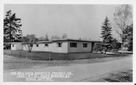
The New Vista Society's Project no. 9
https://search.heritageburnaby.ca/link/archivedescription64681
- Repository
- City of Burnaby Archives
- Date
- March 22, 1957
- Collection/Fonds
- Ernest Winch fonds
- Description Level
- Item
- Physical Description
- 1 photograph : b&w postcard ; 8 x 13 cm
- Scope and Content
- Photographic postcard of New Vista Society housing project no. 9 at 1500 4th Street (later renumbered 7581 4th Street).
- Repository
- City of Burnaby Archives
- Date
- March 22, 1957
- Collection/Fonds
- Ernest Winch fonds
- Physical Description
- 1 photograph : b&w postcard ; 8 x 13 cm
- Description Level
- Item
- Record No.
- 514-012
- Access Restriction
- No restrictions
- Reproduction Restriction
- Reproduce for fair dealing purposes only
- Accession Number
- 2010-06
- Scope and Content
- Photographic postcard of New Vista Society housing project no. 9 at 1500 4th Street (later renumbered 7581 4th Street).
- Names
- New Vista Society
- Media Type
- Photograph
- Photographer
- Stride, Charles Edgar
- Notes
- Transcribed title
- Photographer's note on recto of photograph reads: "The New Vista Society's Project # 9 / 1500 4th St., South Burnaby, B.C. / March 22nd, 1957"
- Geographic Access
- 4th Street
- Street Address
- 7581 4th Street
- Historic Neighbourhood
- East Burnaby (Historic Neighbourhood)
- Planning Study Area
- Second Street Area
Images


Normanna Rest Home
https://search.heritageburnaby.ca/link/archivedescription38296
- Repository
- City of Burnaby Archives
- Date
- 1985
- Collection/Fonds
- Burnaby Historical Society fonds
- Description Level
- Item
- Physical Description
- 1 photograph : b&w ; 12.7 x 17.7 cm
- Scope and Content
- Photograph of the Normanna Rest Home, at 7959 12th Avenue (old street numbering).
- Repository
- City of Burnaby Archives
- Date
- 1985
- Collection/Fonds
- Burnaby Historical Society fonds
- Subseries
- Photographs subseries
- Physical Description
- 1 photograph : b&w ; 12.7 x 17.7 cm
- Description Level
- Item
- Record No.
- 398-003
- Access Restriction
- No restrictions
- Reproduction Restriction
- Reproduce for fair dealing purposes only
- Accession Number
- BHS2007-04
- Scope and Content
- Photograph of the Normanna Rest Home, at 7959 12th Avenue (old street numbering).
- Names
- Normanna Rest Home
- Media Type
- Photograph
- Notes
- Title based on contents of photograph
- Geographic Access
- 4th Street
- Street Address
- 7725 4th Street
- Historic Neighbourhood
- East Burnaby (Historic Neighbourhood)
- Planning Study Area
- Second Street Area
Images
Normanna Rest Home
https://search.heritageburnaby.ca/link/archivedescription79510
- Repository
- City of Burnaby Archives
- Date
- February 7, 1977
- Collection/Fonds
- Burnaby Public Library Contemporary Visual Archive Project
- Description Level
- Item
- Physical Description
- 1 photograph : b&w ; 11 x 16 cm mounted on cardboard
- Scope and Content
- Photograph shows the Normanna Rest Home at 7979 12th Avenue (later 7725 4th Street).
- Repository
- City of Burnaby Archives
- Date
- February 7, 1977
- Collection/Fonds
- Burnaby Public Library Contemporary Visual Archive Project
- Physical Description
- 1 photograph : b&w ; 11 x 16 cm mounted on cardboard
- Description Level
- Item
- Record No.
- 556-337
- Access Restriction
- No restrictions
- Reproduction Restriction
- Reproduce for fair dealing purposes only
- Accession Number
- 2013-13
- Scope and Content
- Photograph shows the Normanna Rest Home at 7979 12th Avenue (later 7725 4th Street).
- Names
- Normanna Rest Home
- Media Type
- Photograph
- Notes
- Scope note taken directly from BPL photograph description.
- 1 b&w copy negative : 10 x 12.5 cm accompanying
- Photographers identified by surnames only: Carr and Vardeman
- Geographic Access
- 4th Street
- Street Address
- 7725 4th Street
- Historic Neighbourhood
- East Burnaby (Historic Neighbourhood)
- Planning Study Area
- Second Street Area
Images

Our Lady of Mercy Church Manse
https://search.heritageburnaby.ca/link/archivedescription35074
- Repository
- City of Burnaby Archives
- Date
- October 21, 1986
- Collection/Fonds
- Burnaby Historical Society fonds
- Description Level
- Item
- Physical Description
- 1 photograph : b&w ; 8.8 x 12.6 cm
- Scope and Content
- Photograph of the exterior of the manse at Our Lady of Mercy Catholic Church, 7455 10th Avenue and Kingsway. The photo was taken before the manse was demolished.
- Repository
- City of Burnaby Archives
- Date
- October 21, 1986
- Collection/Fonds
- Burnaby Historical Society fonds
- Subseries
- Jim Wolf subseries
- Physical Description
- 1 photograph : b&w ; 8.8 x 12.6 cm
- Description Level
- Item
- Record No.
- 188-001
- Access Restriction
- No restrictions
- Reproduction Restriction
- Reproduce for fair dealing purposes only
- Accession Number
- BHS1986-39
- Scope and Content
- Photograph of the exterior of the manse at Our Lady of Mercy Catholic Church, 7455 10th Avenue and Kingsway. The photo was taken before the manse was demolished.
- Subjects
- Buildings - Religious - Churches
- Names
- Our Lady of Mercy Church
- Media Type
- Photograph
- Photographer
- Wolf, Jim
- Notes
- Title based on contents of photograph
- Geographic Access
- 10th Avenue
- Street Address
- 7455 10th Avenue
- Historic Neighbourhood
- Edmonds (Historic Neighbourhood)
- Planning Study Area
- Edmonds Area
Images


Our Lady of Mercy Church Manse
https://search.heritageburnaby.ca/link/archivedescription35075
- Repository
- City of Burnaby Archives
- Date
- October 21, 1986
- Collection/Fonds
- Burnaby Historical Society fonds
- Description Level
- Item
- Physical Description
- 1 photograph : b&w ; 8.8 x 12.6 cm
- Scope and Content
- Photograph of the exterior of the manse at Our Lady of Mercy Catholic Church, 7455 10th Avenue and Kingsway. The photo was taken before the manse was demolished. An automobile is parked outside.
- Repository
- City of Burnaby Archives
- Date
- October 21, 1986
- Collection/Fonds
- Burnaby Historical Society fonds
- Subseries
- Jim Wolf subseries
- Physical Description
- 1 photograph : b&w ; 8.8 x 12.6 cm
- Description Level
- Item
- Record No.
- 188-002
- Access Restriction
- No restrictions
- Reproduction Restriction
- Reproduce for fair dealing purposes only
- Accession Number
- BHS1986-39
- Scope and Content
- Photograph of the exterior of the manse at Our Lady of Mercy Catholic Church, 7455 10th Avenue and Kingsway. The photo was taken before the manse was demolished. An automobile is parked outside.
- Subjects
- Buildings - Religious - Churches
- Names
- Our Lady of Mercy Church
- Media Type
- Photograph
- Photographer
- Wolf, Jim
- Notes
- Title based on contents of photograph
- Geographic Access
- 10th Avenue
- Street Address
- 7455 10th Avenue
- Historic Neighbourhood
- Edmonds (Historic Neighbourhood)
- Planning Study Area
- Edmonds Area
Images


Our Lady of Mercy Church Manse
https://search.heritageburnaby.ca/link/archivedescription35076
- Repository
- City of Burnaby Archives
- Date
- October 21, 1986
- Collection/Fonds
- Burnaby Historical Society fonds
- Description Level
- Item
- Physical Description
- 1 photograph : b&w ; 8.8 x 12.4 cm
- Scope and Content
- Photograph of the exterior of the manse at Our Lady of Mercy Catholic Church, 7455 10th Avenue and Kingsway. The photo was taken before the manse was demolished.
- Repository
- City of Burnaby Archives
- Date
- October 21, 1986
- Collection/Fonds
- Burnaby Historical Society fonds
- Subseries
- Jim Wolf subseries
- Physical Description
- 1 photograph : b&w ; 8.8 x 12.4 cm
- Description Level
- Item
- Record No.
- 188-003
- Access Restriction
- No restrictions
- Reproduction Restriction
- Reproduce for fair dealing purposes only
- Accession Number
- BHS1986-39
- Scope and Content
- Photograph of the exterior of the manse at Our Lady of Mercy Catholic Church, 7455 10th Avenue and Kingsway. The photo was taken before the manse was demolished.
- Subjects
- Buildings - Religious - Churches
- Names
- Our Lady of Mercy Church
- Media Type
- Photograph
- Photographer
- Wolf, Jim
- Notes
- Title based on contents of photograph
- Geographic Access
- 10th Avenue
- Street Address
- 7455 10th Avenue
- Historic Neighbourhood
- Edmonds (Historic Neighbourhood)
- Planning Study Area
- Edmonds Area
Images


Our Lady of Mercy Church Manse
https://search.heritageburnaby.ca/link/archivedescription35077
- Repository
- City of Burnaby Archives
- Date
- October 21, 1986
- Collection/Fonds
- Burnaby Historical Society fonds
- Description Level
- Item
- Physical Description
- 1 photograph : b&w ; 8.8 x 12.6 cm
- Scope and Content
- Photograph of the exterior of the manse at Our Lady of Mercy Catholic Church, 7455 10th Avenue and Kingsway. The photo was taken before the manse was demolished.
- Repository
- City of Burnaby Archives
- Date
- October 21, 1986
- Collection/Fonds
- Burnaby Historical Society fonds
- Subseries
- Jim Wolf subseries
- Physical Description
- 1 photograph : b&w ; 8.8 x 12.6 cm
- Description Level
- Item
- Record No.
- 188-004
- Access Restriction
- No restrictions
- Reproduction Restriction
- Reproduce for fair dealing purposes only
- Accession Number
- BHS1986-39
- Scope and Content
- Photograph of the exterior of the manse at Our Lady of Mercy Catholic Church, 7455 10th Avenue and Kingsway. The photo was taken before the manse was demolished.
- Subjects
- Buildings - Religious - Churches
- Names
- Our Lady of Mercy Church
- Media Type
- Photograph
- Photographer
- Wolf, Jim
- Notes
- Title based on contents of photograph
- Geographic Access
- 10th Avenue
- Street Address
- 7455 10th Avenue
- Historic Neighbourhood
- Edmonds (Historic Neighbourhood)
- Planning Study Area
- Edmonds Area
Images


Our Lady of Mercy Church Manse
https://search.heritageburnaby.ca/link/archivedescription35078
- Repository
- City of Burnaby Archives
- Date
- October 21, 1986
- Collection/Fonds
- Burnaby Historical Society fonds
- Description Level
- Item
- Physical Description
- 1 photograph : b&w ; 8.8 x 12.4 cm
- Scope and Content
- Photograph of the exterior of the manse at Our Lady of Mercy Catholic Church, 7455 10th Avenue and Kingsway. The photo was taken before the manse was demolished. The church is at the left side of the photo, and the manse is at the right side.
- Repository
- City of Burnaby Archives
- Date
- October 21, 1986
- Collection/Fonds
- Burnaby Historical Society fonds
- Subseries
- Jim Wolf subseries
- Physical Description
- 1 photograph : b&w ; 8.8 x 12.4 cm
- Description Level
- Item
- Record No.
- 188-005
- Access Restriction
- No restrictions
- Reproduction Restriction
- Reproduce for fair dealing purposes only
- Accession Number
- BHS1986-39
- Scope and Content
- Photograph of the exterior of the manse at Our Lady of Mercy Catholic Church, 7455 10th Avenue and Kingsway. The photo was taken before the manse was demolished. The church is at the left side of the photo, and the manse is at the right side.
- Subjects
- Buildings - Religious - Churches
- Names
- Our Lady of Mercy Church
- Media Type
- Photograph
- Photographer
- Wolf, Jim
- Notes
- Title based on contents of photograph
- Geographic Access
- 10th Avenue
- Street Address
- 7455 10th Avenue
- Historic Neighbourhood
- Edmonds (Historic Neighbourhood)
- Planning Study Area
- Edmonds Area
Images


Our Lady of Mercy Church Manse
https://search.heritageburnaby.ca/link/archivedescription35079
- Repository
- City of Burnaby Archives
- Date
- October 21, 1986
- Collection/Fonds
- Burnaby Historical Society fonds
- Description Level
- Item
- Physical Description
- 1 photograph : b&w ; 8.8 x 12.5 cm
- Scope and Content
- Photograph of the exterior of the manse at Our Lady of Mercy Catholic Church, 7455 10th Avenue and Kingsway. The photo was taken before the manse was demolished. The church is at the left side of the photo, and the manse is at the right side.
- Repository
- City of Burnaby Archives
- Date
- October 21, 1986
- Collection/Fonds
- Burnaby Historical Society fonds
- Subseries
- Jim Wolf subseries
- Physical Description
- 1 photograph : b&w ; 8.8 x 12.5 cm
- Description Level
- Item
- Record No.
- 188-006
- Access Restriction
- No restrictions
- Reproduction Restriction
- Reproduce for fair dealing purposes only
- Accession Number
- BHS1986-39
- Scope and Content
- Photograph of the exterior of the manse at Our Lady of Mercy Catholic Church, 7455 10th Avenue and Kingsway. The photo was taken before the manse was demolished. The church is at the left side of the photo, and the manse is at the right side.
- Subjects
- Buildings - Religious - Churches
- Names
- Our Lady of Mercy Church
- Media Type
- Photograph
- Photographer
- Wolf, Jim
- Notes
- Title based on contents of photograph
- Geographic Access
- 10th Avenue
- Street Address
- 7455 10th Avenue
- Historic Neighbourhood
- Edmonds (Historic Neighbourhood)
- Planning Study Area
- Edmonds Area
Images


Our Lady of Mercy Rectory
https://search.heritageburnaby.ca/link/archivedescription79044
- Repository
- City of Burnaby Archives
- Date
- September 10, 1976
- Collection/Fonds
- Burnaby Public Library Contemporary Visual Archive Project
- Description Level
- Item
- Physical Description
- 1 photograph : b&w ; 11 x 16 cm mounted on cardboard
- Scope and Content
- Photograph shows the Our Lady of Mercy Rectory located at 7892 Kingsway (later 7455 10th Avenue).
- Repository
- City of Burnaby Archives
- Date
- September 10, 1976
- Collection/Fonds
- Burnaby Public Library Contemporary Visual Archive Project
- Physical Description
- 1 photograph : b&w ; 11 x 16 cm mounted on cardboard
- Description Level
- Item
- Record No.
- 556-111
- Access Restriction
- No restrictions
- Reproduction Restriction
- Reproduce for fair dealing purposes only
- Accession Number
- 2013-13
- Scope and Content
- Photograph shows the Our Lady of Mercy Rectory located at 7892 Kingsway (later 7455 10th Avenue).
- Subjects
- Buildings - Religious - Churches
- Names
- Our Lady of Mercy Church
- Media Type
- Photograph
- Photographer
- Ross, Martha
- Notes
- Scope note taken directly from BPL photograph description.
- 1 b&w copy negative : 10 x 12.5 cm accompanying
- Geographic Access
- Kingsway
- 10th Avenue
- Street Address
- 7892 Kingsway
- 7455 10th Avenue
- Historic Neighbourhood
- Edmonds (Historic Neighbourhood)
- Planning Study Area
- Edmonds Area
Images


Parish Church of Our Lady of Mercy
https://search.heritageburnaby.ca/link/archivedescription79043
- Repository
- City of Burnaby Archives
- Date
- September 16, 1976
- Collection/Fonds
- Burnaby Public Library Contemporary Visual Archive Project
- Description Level
- Item
- Physical Description
- 1 photograph : b&w ; 11 x 16 cm mounted on cardboard
- Scope and Content
- Photograph shows the Parish Church of Our Lady of Mercy located at 7892 Kingsway (later 7455 10th Avenue). Construction of this church was held up by World War II but it was completed in 1944.
- Repository
- City of Burnaby Archives
- Date
- September 16, 1976
- Collection/Fonds
- Burnaby Public Library Contemporary Visual Archive Project
- Physical Description
- 1 photograph : b&w ; 11 x 16 cm mounted on cardboard
- Description Level
- Item
- Record No.
- 556-110
- Access Restriction
- No restrictions
- Reproduction Restriction
- Reproduce for fair dealing purposes only
- Accession Number
- 2013-13
- Scope and Content
- Photograph shows the Parish Church of Our Lady of Mercy located at 7892 Kingsway (later 7455 10th Avenue). Construction of this church was held up by World War II but it was completed in 1944.
- Subjects
- Buildings - Religious - Churches
- Names
- Our Lady of Mercy Church
- Media Type
- Photograph
- Photographer
- Born, A. J.
- Notes
- Scope note taken directly from BPL photograph description.
- 1 b&w copy negative : 10 x 12.5 cm accompanying
- Geographic Access
- Kingsway
- 10th Avenue
- Street Address
- 7892 Kingsway
- 7455 10th Avenue
- Historic Neighbourhood
- Edmonds (Historic Neighbourhood)
- Planning Study Area
- Edmonds Area
Images

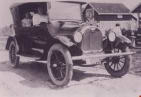
Pollard family car
https://search.heritageburnaby.ca/link/archivedescription37356
- Repository
- City of Burnaby Archives
- Date
- 1920 (date of original), copied 1998
- Collection/Fonds
- Burnaby Historical Society fonds
- Description Level
- Item
- Physical Description
- 1 photograph : b&w ; 12.8 x 17.5 cm print
- Scope and Content
- Photograph of the Pollard family's first car, a 1920-1922 Chevrolet Four-ninety Touring Car (so named because of selling price of $490.00). Agnes Pollard is sitting on the passenger side at the front and her May is sitting in the back. This photograph was likely taken near the family home at 17th A…
- Repository
- City of Burnaby Archives
- Date
- 1920 (date of original), copied 1998
- Collection/Fonds
- Burnaby Historical Society fonds
- Subseries
- Pollard family subseries
- Physical Description
- 1 photograph : b&w ; 12.8 x 17.5 cm print
- Description Level
- Item
- Record No.
- 359-002
- Access Restriction
- No restrictions
- Reproduction Restriction
- No known restrictions
- Accession Number
- BHS1998-09
- Scope and Content
- Photograph of the Pollard family's first car, a 1920-1922 Chevrolet Four-ninety Touring Car (so named because of selling price of $490.00). Agnes Pollard is sitting on the passenger side at the front and her May is sitting in the back. This photograph was likely taken near the family home at 17th Avenue and 4th Street.
- Subjects
- Transportation - Automobiles
- Media Type
- Photograph
- Notes
- Title based on contents of photograph.
- Geographic Access
- 17th Avenue
- 4th Street
- Historic Neighbourhood
- East Burnaby (Historic Neighbourhood)
- Planning Study Area
- Second Street Area
Images
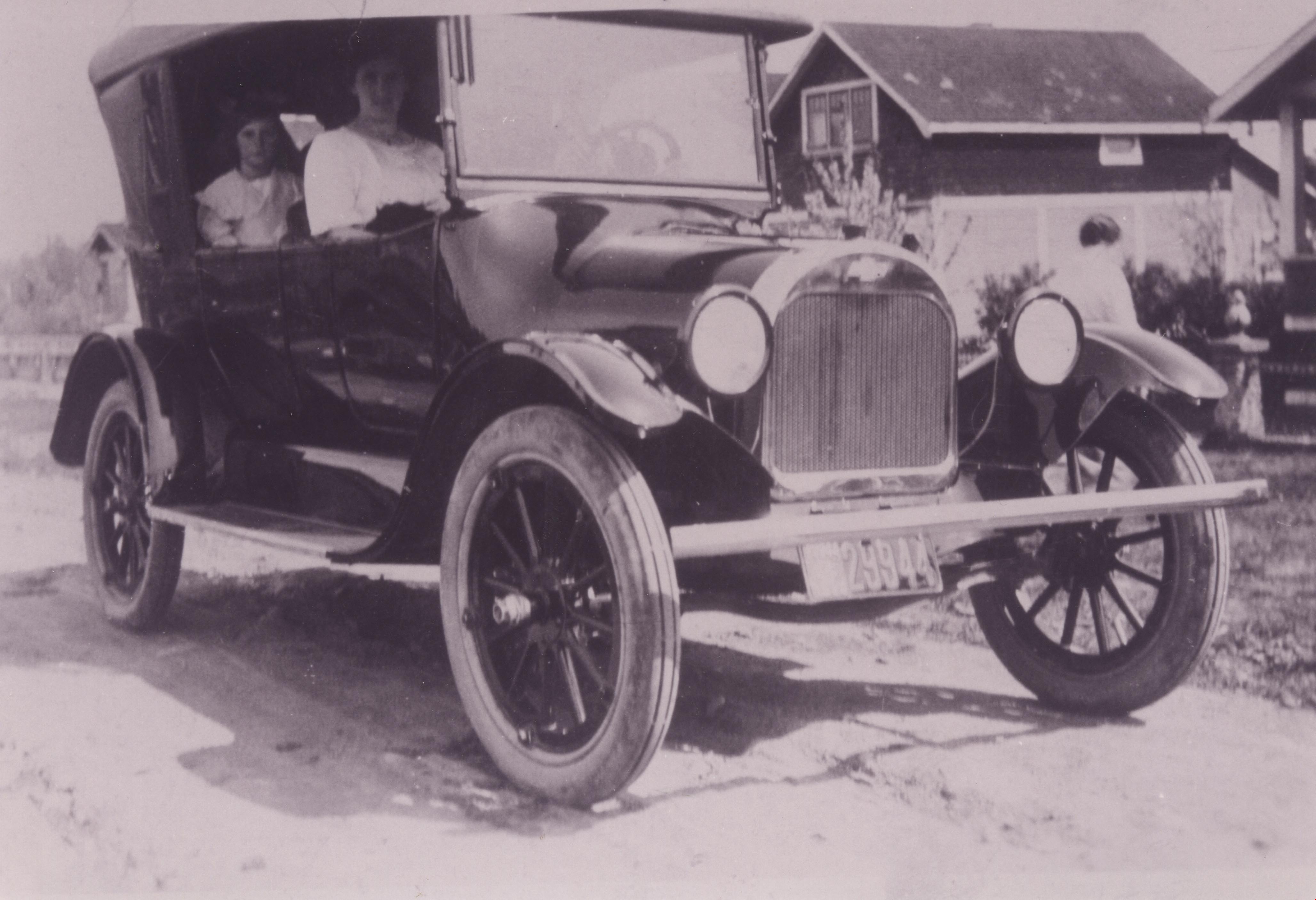
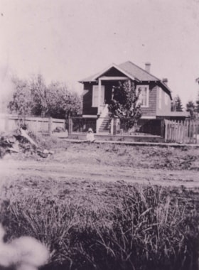
Pollard family house
https://search.heritageburnaby.ca/link/archivedescription37355
- Repository
- City of Burnaby Archives
- Date
- 1914 (date of original), copied 1998
- Collection/Fonds
- Burnaby Historical Society fonds
- Description Level
- Item
- Physical Description
- 1 photograph : b&w ; 12.5 x 17.5 cm print
- Scope and Content
- Photograph of the Pollard family house at 17th Avenue near 4th Street in East Burnaby. Eldest daughter May is seated on the sidewalk in front of the house.
- Repository
- City of Burnaby Archives
- Date
- 1914 (date of original), copied 1998
- Collection/Fonds
- Burnaby Historical Society fonds
- Subseries
- Pollard family subseries
- Physical Description
- 1 photograph : b&w ; 12.5 x 17.5 cm print
- Description Level
- Item
- Record No.
- 359-001
- Access Restriction
- No restrictions
- Reproduction Restriction
- No known restrictions
- Accession Number
- BHS1998-09
- Scope and Content
- Photograph of the Pollard family house at 17th Avenue near 4th Street in East Burnaby. Eldest daughter May is seated on the sidewalk in front of the house.
- Subjects
- Buildings - Residential - Houses
- Names
- Pollard, May
- Media Type
- Photograph
- Notes
- Title based on contents of photograph
- Geographic Access
- 17th Avenue
- 4th Street
- Historic Neighbourhood
- East Burnaby (Historic Neighbourhood)
- Planning Study Area
- Second Street Area
Images
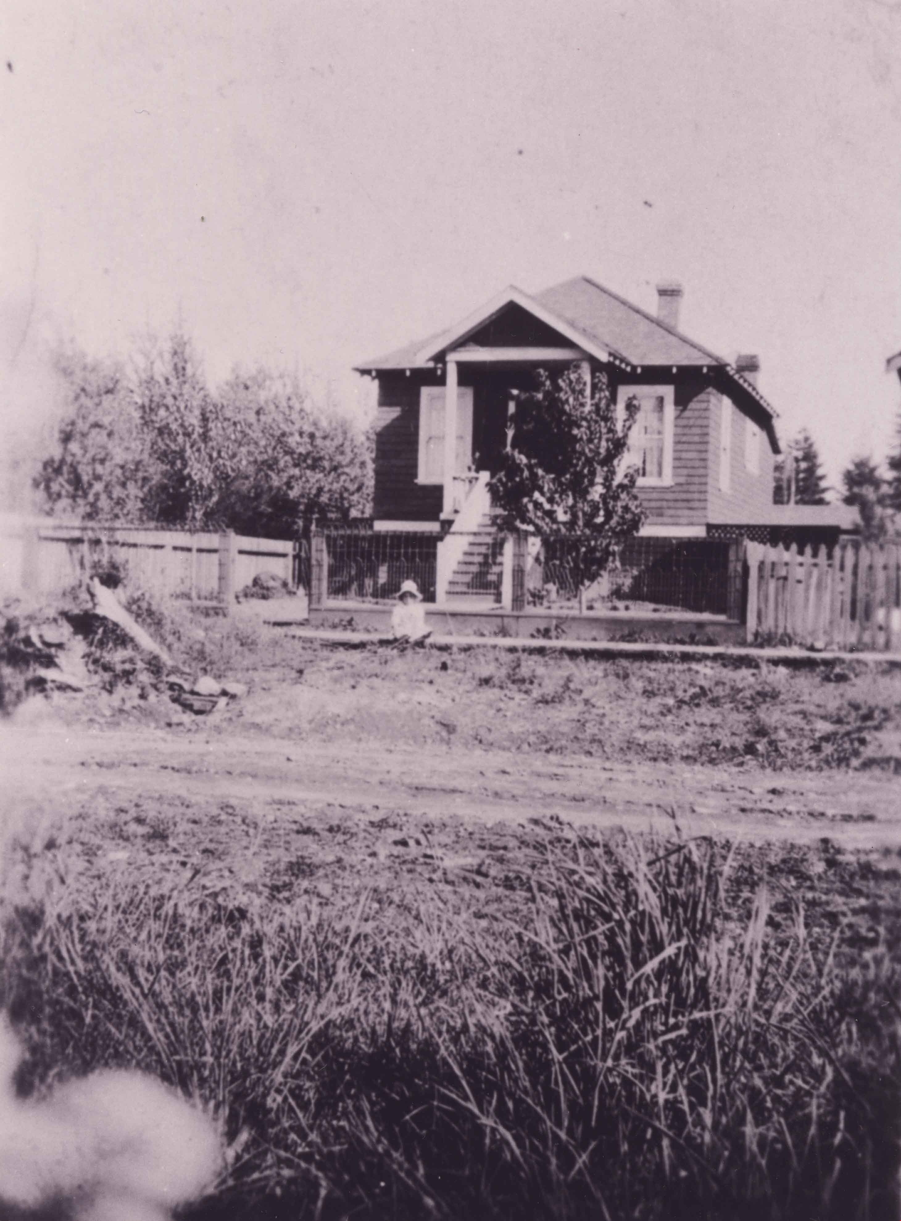
![Ramsey family, [1916] (date of original), copied [1999] thumbnail](/media/hpo/_Data/_Archives_Images/_Unrestricted/371/399-001.jpg?width=280)
Ramsey family
https://search.heritageburnaby.ca/link/archivedescription38301
- Repository
- City of Burnaby Archives
- Date
- [1916] (date of original), copied [1999]
- Collection/Fonds
- Burnaby Historical Society fonds
- Description Level
- Item
- Physical Description
- 1 photograph : b&w ; 20.2 x 25.3 cm print
- Scope and Content
- Photograph of seven members of the Ramsey family in the backyard of home at 12th Avenue and 4th Street. Identified are: standing (l to r): Eva Lillian Ramsey, Annie Ramsey (mother), and Queenie Ramsey. Seated (l to r): Dorothy Ramsey, Ernest Ramsey (twin to Dorothy), Gordon Ramsey and Jessie Ramse…
- Repository
- City of Burnaby Archives
- Date
- [1916] (date of original), copied [1999]
- Collection/Fonds
- Burnaby Historical Society fonds
- Subseries
- Ramsey family subseries
- Physical Description
- 1 photograph : b&w ; 20.2 x 25.3 cm print
- Description Level
- Item
- Record No.
- 399-001
- Access Restriction
- No restrictions
- Reproduction Restriction
- No known restrictions
- Accession Number
- BHS1999-19
- Scope and Content
- Photograph of seven members of the Ramsey family in the backyard of home at 12th Avenue and 4th Street. Identified are: standing (l to r): Eva Lillian Ramsey, Annie Ramsey (mother), and Queenie Ramsey. Seated (l to r): Dorothy Ramsey, Ernest Ramsey (twin to Dorothy), Gordon Ramsey and Jessie Ramsey.
- Names
- Ramsey, Annie
- Ramsey, Dorothy
- Ramsey, Ernest
- Ramsey, Eva Lillian
- Ramsey, Gordon
- Ramsey, Jessie
- Ramsey, Queenie
- Media Type
- Photograph
- Notes
- Title based on contents of photograph
- Geographic Access
- 4th Street
- 12th Avenue
- Historic Neighbourhood
- East Burnaby (Historic Neighbourhood)
- Planning Study Area
- Second Street Area
Images
![Ramsey family, [1916] (date of original), copied [1999] thumbnail](/media/hpo/_Data/_Archives_Images/_Unrestricted/371/399-001.jpg)
![Robert Nasato at Marine/10th Ave. Connector, [2000] thumbnail](/media/hpo/_Data/_Archives_Images/_Unrestricted/535/535-3069.jpg?width=280)
Robert Nasato at Marine/10th Ave. Connector
https://search.heritageburnaby.ca/link/archivedescription97943
- Repository
- City of Burnaby Archives
- Date
- [2000]
- Collection/Fonds
- Burnaby NewsLeader photograph collection
- Description Level
- Item
- Physical Description
- 1 photograph (tiff) : col.
- Scope and Content
- Photograph of Robert Nasato, the president of the West End Residents' Association, posing net to sign advertising the plans for the Marine/10th Ave. Connector.
- Repository
- City of Burnaby Archives
- Date
- [2000]
- Collection/Fonds
- Burnaby NewsLeader photograph collection
- Physical Description
- 1 photograph (tiff) : col.
- Description Level
- Item
- Record No.
- 535-3069
- Access Restriction
- No restrictions
- Reproduction Restriction
- No restrictions
- Accession Number
- 2018-12
- Scope and Content
- Photograph of Robert Nasato, the president of the West End Residents' Association, posing net to sign advertising the plans for the Marine/10th Ave. Connector.
- Media Type
- Photograph
- Photographer
- Bartel, Mario
- Notes
- Title based on caption
- Collected by editorial for use in a January 2000 issue of the Burnaby NewsLeader
- Caption from metadata: "Robert Nasato, the president of the West End Residents' Association, isn't happy about the proposed Marine/10th Ave. connector, to be built through his neighborhood."
- Geographic Access
- 10th Avenue
- Marine Drive
- Historic Neighbourhood
- Fraser Arm (Historic Neighbourhood)
- Planning Study Area
- Stride Hill Area
Images
![Robert Nasato at Marine/10th Ave. Connector, [2000] thumbnail](/media/hpo/_Data/_Archives_Images/_Unrestricted/535/535-3069.jpg)

Running track at Saint Thomas More Collegiate
https://search.heritageburnaby.ca/link/archivedescription78788
- Repository
- City of Burnaby Archives
- Date
- 2001 (date of original); 2013 (date of annotation)
- Collection/Fonds
- Walker family fonds
- Description Level
- Item
- Physical Description
- 1 photograph (jpeg) : col. ; 300 dpi
- Scope and Content
- Photograph of the running track at Saint Thomas More Collegiate with Our Lady of Mercy Parish visible in the background.
- Repository
- City of Burnaby Archives
- Date
- 2001 (date of original); 2013 (date of annotation)
- Collection/Fonds
- Walker family fonds
- Physical Description
- 1 photograph (jpeg) : col. ; 300 dpi
- Description Level
- Item
- Record No.
- 557-038
- Access Restriction
- No restrictions
- Reproduction Restriction
- No known restrictions
- Accession Number
- 2013-15
- Scope and Content
- Photograph of the running track at Saint Thomas More Collegiate with Our Lady of Mercy Parish visible in the background.
- Subjects
- Buildings - Religious - Churches
- Media Type
- Photograph
- Notes
- Title based on contents of photograph
- Geographic Access
- 10th Avenue
- Historic Neighbourhood
- Edmonds (Historic Neighbourhood)
- Planning Study Area
- Edmonds Area
Images


Running track at Saint Thomas More Collegiate
https://search.heritageburnaby.ca/link/archivedescription78789
- Repository
- City of Burnaby Archives
- Date
- 2001 (date of original); 2013 (date of annotation)
- Collection/Fonds
- Walker family fonds
- Description Level
- Item
- Physical Description
- 1 photograph (jpeg) : col. ; 300 dpi
- Scope and Content
- Photograph of the running track at Saint Thomas More Collegiate with the school visible in the background.
- Repository
- City of Burnaby Archives
- Date
- 2001 (date of original); 2013 (date of annotation)
- Collection/Fonds
- Walker family fonds
- Physical Description
- 1 photograph (jpeg) : col. ; 300 dpi
- Description Level
- Item
- Record No.
- 557-039
- Access Restriction
- No restrictions
- Reproduction Restriction
- No known restrictions
- Accession Number
- 2013-15
- Scope and Content
- Photograph of the running track at Saint Thomas More Collegiate with the school visible in the background.
- Subjects
- Buildings - Schools
- Media Type
- Photograph
- Notes
- Title based on contents of photograph
- Geographic Access
- 10th Avenue
- Historic Neighbourhood
- Edmonds (Historic Neighbourhood)
- Planning Study Area
- Edmonds Area
Images


Running track at Saint Thomas More Collegiate
https://search.heritageburnaby.ca/link/archivedescription78790
- Repository
- City of Burnaby Archives
- Date
- 2001 (date of original); 2013 (date of annotation)
- Collection/Fonds
- Walker family fonds
- Description Level
- Item
- Physical Description
- 1 photograph (jpeg) : col. ; 96 dpi
- Scope and Content
- Photograph of the running track at Saint Thomas More Collegiate with the school visible in the background.
- Repository
- City of Burnaby Archives
- Date
- 2001 (date of original); 2013 (date of annotation)
- Collection/Fonds
- Walker family fonds
- Physical Description
- 1 photograph (jpeg) : col. ; 96 dpi
- Description Level
- Item
- Record No.
- 557-040
- Access Restriction
- No restrictions
- Reproduction Restriction
- No known restrictions
- Accession Number
- 2013-15
- Scope and Content
- Photograph of the running track at Saint Thomas More Collegiate with the school visible in the background.
- Subjects
- Buildings - Schools
- Media Type
- Photograph
- Notes
- Title based on contents of photograph
- Geographic Access
- 10th Avenue
- Historic Neighbourhood
- Edmonds (Historic Neighbourhood)
- Planning Study Area
- Edmonds Area
Images


Silvanovicz family
https://search.heritageburnaby.ca/link/archivedescription36850
- Repository
- City of Burnaby Archives
- Date
- 1934
- Collection/Fonds
- Burnaby Historical Society fonds
- Description Level
- Item
- Physical Description
- 1 photograph : b&w ; 9 x 13 cm print
- Scope and Content
- Photograph of the first Silvanovicz family home at 2109 Willard Street (old street numbering system). Members of the Sivanovicz family are in front, left to right: Helen (daughter), Mary (mother), and Alex (son).
- Repository
- City of Burnaby Archives
- Date
- 1934
- Collection/Fonds
- Burnaby Historical Society fonds
- Subseries
- Burnaby Centennial Anthology subseries
- Physical Description
- 1 photograph : b&w ; 9 x 13 cm print
- Description Level
- Item
- Record No.
- 315-308
- Access Restriction
- No restrictions
- Reproduction Restriction
- No known restrictions
- Accession Number
- BHS1994-04
- Scope and Content
- Photograph of the first Silvanovicz family home at 2109 Willard Street (old street numbering system). Members of the Sivanovicz family are in front, left to right: Helen (daughter), Mary (mother), and Alex (son).
- Media Type
- Photograph
- Notes
- Title based on contents of photograph
- Geographic Access
- Willard Street
- 12th Avenue
- 10th Avenue
- Historic Neighbourhood
- Fraser Arm (Historic Neighbourhood)
- Planning Study Area
- Big Bend Area
Images
