Narrow Results By
Subject
- Advertising Medium 5
- Advertising Medium - Flyer
- Advertising Medium - Signs and Signboards 2
- Aerial Photographs 1
- Agricultural Tools and Equipment - Gardening Equipment 1
- Arts 3
- Arts - Paintings 2
- Buildings 1
- Buildings - Civic - City Halls 2
- Buildings - Civic - Fire Halls 1
- Buildings - Civic - Seniors Centres 2
- Buildings - Commercial

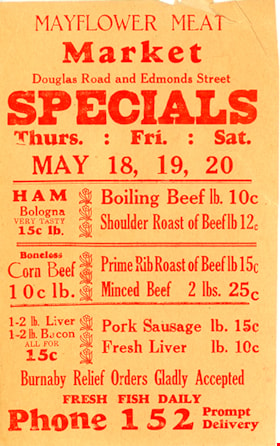
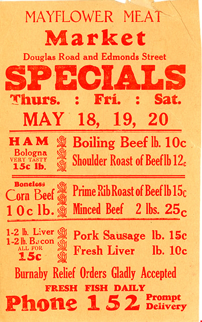
advertising flyer
https://search.heritageburnaby.ca/link/museumartifact1787
- Repository
- Burnaby Village Museum
- Accession Code
- HV971.105.1
- Description
- Meat Specials! - Advertising flyer. Produced for Mayflower Meat Market, Douglas Road and Edmonds Street, Phone 152
- Object History
- Donor owned the Mayflower Meat Market.
- Maker
- Royal Press
- Country Made
- Canada
- Province Made
- British Columbia
- Site/City Made
- New Westminster
- Geographic Access
- Douglas Road
- Edmonds Street
- Historic Neighbourhood
- Edmonds (Historic Neighbourhood)
Images


advertising flyer
https://search.heritageburnaby.ca/link/museumartifact1788
- Repository
- Burnaby Village Museum
- Accession Code
- HV971.105.2
- Description
- Depednable Quality Plus Real Economy - Advertising flyer. Produced for for Mayflower Meat Market, Edmonds Street at Douglas Road; Phone 152
- Object History
- Donor owned the Mayflower Meat Market on Grandview-Douglas Highway.
- Country Made
- Canada
- Geographic Access
- Douglas Road
- Edmonds Street
- Historic Neighbourhood
- Edmonds (Historic Neighbourhood)
Images

advertising flyer
https://search.heritageburnaby.ca/link/museumartifact1789
- Repository
- Burnaby Village Museum
- Accession Code
- HV971.105.3
- Description
- Mayflower Meat Market - Advertising flyer. Produced for Mayflower Meat Market, Douglas Road and Edmonds Street; Phone 152
- Object History
- Donor owned the Mayflower Meat Market.
- Geographic Access
- Douglas Road
- Edmonds Street
- Historic Neighbourhood
- Edmonds (Historic Neighbourhood)
Images
advertising flyer
https://search.heritageburnaby.ca/link/museumartifact1790
- Repository
- Burnaby Village Museum
- Accession Code
- HV971.105.4
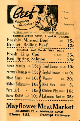
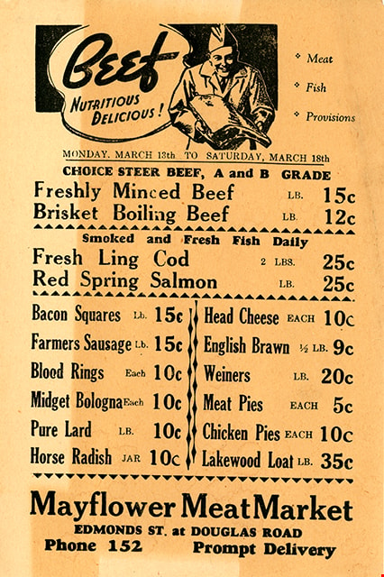
- Description
- Beef, Nutritious, Delicious! - Advertising flyer. Produced for the Mayflower Meat Market, Edmonds Street at Douglas Road; phone 152
- Object History
- Donor owned the Mayflower Meat Market.
- Geographic Access
- Douglas Road
- Edmonds Street
- Historic Neighbourhood
- Edmonds (Historic Neighbourhood)
Images
advertising flyer
https://search.heritageburnaby.ca/link/museumartifact1791
- Repository
- Burnaby Village Museum
- Accession Code
- HV971.105.5
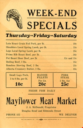
- Description
- Week-End Specials - Advertising flyer. Produced for Mayflower Meat Market, Douglas Road and Edmonds Street; phone 152; J.A. McDonald, proprietor
- Object History
- Donor owned the Mayflower Meat Market.
- Geographic Access
- Douglas Road
- Edmonds Street
- Historic Neighbourhood
- Edmonds (Historic Neighbourhood)
Images

![Edmonds and Kingsway, 1912 (date of original), copied [1997] thumbnail](/media/hpo/_Data/_Archives_Images/_Unrestricted/316/350-015.jpg?width=280)
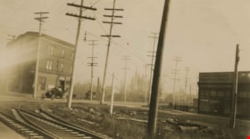
Edmonds and Kingsway
https://search.heritageburnaby.ca/link/archivedescription37321
- Repository
- City of Burnaby Archives
- Date
- 1912 (date of original), copied [1997]
- Collection/Fonds
- Burnaby Historical Society fonds
- Description Level
- Item
- Physical Description
- 1 photograph : b&w ; 9 x 12 cm print
- Scope and Content
- Photograph of the area near the Edmonds and Kingsway intersection. A British Columbia Electric Railway Company tram is visible in the centre and the station can be seen to the left.
- Repository
- City of Burnaby Archives
- Date
- 1912 (date of original), copied [1997]
- Collection/Fonds
- Burnaby Historical Society fonds
- Subseries
- Jim Wolf subseries
- Physical Description
- 1 photograph : b&w ; 9 x 12 cm print
- Description Level
- Item
- Record No.
- 350-015
- Access Restriction
- No restrictions
- Reproduction Restriction
- No known restrictions
- Accession Number
- BHS1997-09
- Scope and Content
- Photograph of the area near the Edmonds and Kingsway intersection. A British Columbia Electric Railway Company tram is visible in the centre and the station can be seen to the left.
- Media Type
- Photograph
- Notes
- Title based on contents of photograph.
- Geographic Access
- Edmonds Street
- Kingsway
- Historic Neighbourhood
- Edmonds (Historic Neighbourhood)
- Planning Study Area
- Richmond Park Area
Images
![Edmonds and Kingsway, 1912 (date of original), copied [1997] thumbnail](/media/hpo/_Data/_Archives_Images/_Unrestricted/316/350-015.jpg)
Edmonds and Kingsway
https://search.heritageburnaby.ca/link/archivedescription36162
- Repository
- City of Burnaby Archives
- Date
- 1913
- Collection/Fonds
- Burnaby Historical Society fonds
- Description Level
- Item
- Physical Description
- 1 photograph : sepia ; 7 x 12 cm
- Scope and Content
- Photograph of the railway junction and hydro poles at Edmonds and Kingsway, and the "triangle block" on the far right. A touring car is visible moving though the backgound.
- Repository
- City of Burnaby Archives
- Date
- 1913
- Collection/Fonds
- Burnaby Historical Society fonds
- Physical Description
- 1 photograph : sepia ; 7 x 12 cm
- Description Level
- Item
- Record No.
- 230-007
- Access Restriction
- No restrictions
- Reproduction Restriction
- No known restrictions
- Accession Number
- BHS1989-22
- Scope and Content
- Photograph of the railway junction and hydro poles at Edmonds and Kingsway, and the "triangle block" on the far right. A touring car is visible moving though the backgound.
- Media Type
- Photograph
- Notes
- Title based on contents of photograph
- Geographic Access
- Edmonds Street
- Kingsway
- Historic Neighbourhood
- Edmonds (Historic Neighbourhood)
- Planning Study Area
- Edmonds Area
Images
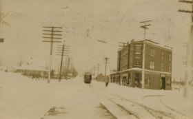
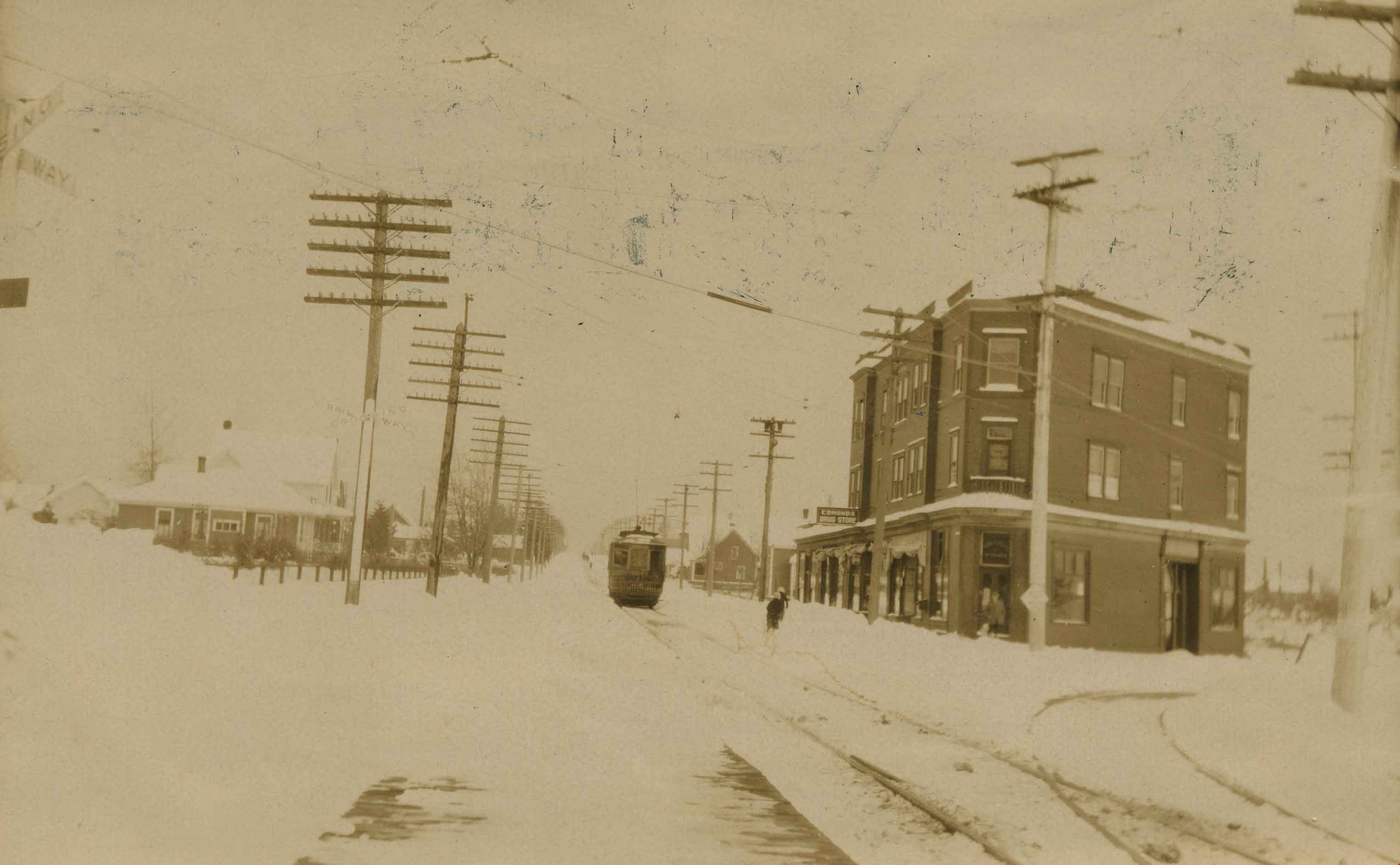
Edmonds and Kingsway tramline
https://search.heritageburnaby.ca/link/archivedescription36163
- Repository
- City of Burnaby Archives
- Date
- 1913
- Collection/Fonds
- Burnaby Historical Society fonds
- Description Level
- Item
- Physical Description
- 1 photograph : sepia ; 8 x 13 cm
- Scope and Content
- Photograph of the railway junction and hydro poles at Edmonds and Kingsway, with the "triangle block" on the left. A tram is visible moving along the snow covered line to New Westminister, via East Burnaby.
- Repository
- City of Burnaby Archives
- Date
- 1913
- Collection/Fonds
- Burnaby Historical Society fonds
- Physical Description
- 1 photograph : sepia ; 8 x 13 cm
- Description Level
- Item
- Record No.
- 230-008
- Access Restriction
- No restrictions
- Reproduction Restriction
- No known restrictions
- Accession Number
- BHS1989-22
- Scope and Content
- Photograph of the railway junction and hydro poles at Edmonds and Kingsway, with the "triangle block" on the left. A tram is visible moving along the snow covered line to New Westminister, via East Burnaby.
- Media Type
- Photograph
- Notes
- Title based on contents of photograph
- Geographic Access
- Edmonds Street
- Kingsway
- Historic Neighbourhood
- Edmonds (Historic Neighbourhood)
- Planning Study Area
- Edmonds Area
Images
4260 Edmonds St.
https://search.heritageburnaby.ca/link/archivedescription94351
- Repository
- City of Burnaby Archives
- Date
- October 1995
- Collection/Fonds
- Grover, Elliott & Co. Ltd. fonds
- Description Level
- File
- Physical Description
- 26 photographs : col. negatives ; 35 mm
- Scope and Content
- Photographs of the exterior of Lumberland, located at 4260 Edmonds Street (an address that no longer exists) and the surrounding area at Edmonds Street and Kingsway.
- Repository
- City of Burnaby Archives
- Date
- October 1995
- Collection/Fonds
- Grover, Elliott & Co. Ltd. fonds
- Physical Description
- 26 photographs : col. negatives ; 35 mm
- Description Level
- File
- Record No.
- 622-136
- Access Restriction
- No restrictions
- Reproduction Restriction
- No restrictions
- Accession Number
- 2017-39
- Scope and Content
- Photographs of the exterior of Lumberland, located at 4260 Edmonds Street (an address that no longer exists) and the surrounding area at Edmonds Street and Kingsway.
- Subjects
- Buildings - Commercial
- Names
- Lumberland
- Media Type
- Photograph
- Photographer
- Young, Richard
- Notes
- Transcribed title
- Title transcribed from envelope photographs were originally housed in
- File no. 95-358-B
- Sticky note adhered to 622-135-1 print reads: "3) View north east from Edmonds St."
- Sticky note adhered to 622-135-2 print reads: "4) View east along Kingsway"
- Sticky note adhered to 622-135-5 print reads: "8) View south along the east lane"
- Sticky note adhered to 622-135-8 print reads: "2) View south west from Kingsway"
- Sticky note adhered to 622-135-11 print reads: "5) View west along Kingsway"
- Sticky note adhered to 622-135-14 print reads: "1) View south from Kingsway"
- Sticky note adhered to 622-135-18 print reads: "6) View south along Edmonds St."
- Sticky note adhered to 622-135-21 print reads: "7) View north along Edmonds St."
- Geographic Access
- Edmonds Street
- Kingsway

Oh! Zhhu Sam
https://search.heritageburnaby.ca/link/archivedescription98681
- Repository
- City of Burnaby Archives
- Date
- 2022
- Collection/Fonds
- Disappearing Burnaby collection
- Description Level
- Item
- Physical Description
- 1 photograph (jpeg) : col.
- Scope and Content
- Photograph of the 7500 block of Edmonds Street at dusk. The photograph is taken from across Edmonds Street and depicts two commercial buildings: Oh! Zzhu Sam Korean Restaurant and the European Butcher Boy Delicatessen & Grocery. Oh! Zzhu Sam, located at 7506 Edmonds Street, was constructed in 1976.…
- Repository
- City of Burnaby Archives
- Date
- 2022
- Collection/Fonds
- Disappearing Burnaby collection
- Physical Description
- 1 photograph (jpeg) : col.
- Description Level
- Item
- Record No.
- 634-028
- Access Restriction
- No restrictions
- Reproduction Restriction
- No restrictions
- Accession Number
- 2022-14
- Scope and Content
- Photograph of the 7500 block of Edmonds Street at dusk. The photograph is taken from across Edmonds Street and depicts two commercial buildings: Oh! Zzhu Sam Korean Restaurant and the European Butcher Boy Delicatessen & Grocery. Oh! Zzhu Sam, located at 7506 Edmonds Street, was constructed in 1976. Residential houses border the restaurant and grocery store, and a bus shelter, municipal garbage can, and the restaurant's illuminated neon sign stand in front of the buildings.
- Subjects
- Buildings - Commercial
- Buildings - Commercial - Grocery Stores
- Buildings - Commercial - Restaurants
- Media Type
- Photograph
- Photographer
- Cheung, Nakita
- Notes
- Title taken from the associated blog post
- Associated blog post: https://disappearingburnaby.wordpress.com/2022/07/29/oh-zzhu-sam/
- Geographic Access
- Edmonds Street
- Street Address
- 7506 Edmonds Street
- Historic Neighbourhood
- Edmonds (Historic Neighbourhood)
- Planning Study Area
- Edmonds Area
Images


Lost in the 50's Drive-In sign
https://search.heritageburnaby.ca/link/archivedescription98682
- Repository
- City of Burnaby Archives
- Date
- 2022
- Collection/Fonds
- Disappearing Burnaby collection
- Description Level
- Item
- Physical Description
- 1 photograph (jpeg) : col.
- Scope and Content
- Photograph of the historic "Arrow Neon Sign" at 50's Burgers, a restaurant located at 7741 Edmonds Street. The photograph depicts the sign, which reads: "Lost in the 50's Drive-In," against the sky at dusk.
- Repository
- City of Burnaby Archives
- Date
- 2022
- Collection/Fonds
- Disappearing Burnaby collection
- Physical Description
- 1 photograph (jpeg) : col.
- Description Level
- Item
- Record No.
- 634-029
- Access Restriction
- No restrictions
- Reproduction Restriction
- No restrictions
- Accession Number
- 2022-14
- Scope and Content
- Photograph of the historic "Arrow Neon Sign" at 50's Burgers, a restaurant located at 7741 Edmonds Street. The photograph depicts the sign, which reads: "Lost in the 50's Drive-In," against the sky at dusk.
- Media Type
- Photograph
- Photographer
- Cheung, Nakita
- Notes
- Title taken from the associated blog post
- Associated blog post: https://disappearingburnaby.wordpress.com/2022/06/30/lost-in-the-50s-drive-in/
- Geographic Access
- Edmonds Street
- Street Address
- 7741 Edmonds Street
- Historic Neighbourhood
- East Burnaby (Historic Neighbourhood)
- Planning Study Area
- Lakeview-Mayfield Area
Images
