Narrow Results By

House at 7945 12th Avenue
https://search.heritageburnaby.ca/link/archivedescription78890
- Repository
- City of Burnaby Archives
- Date
- February 7, 1977
- Collection/Fonds
- Burnaby Public Library Contemporary Visual Archive Project
- Description Level
- Item
- Physical Description
- 1 photograph : b&w ; 11 x 16 cm mounted on cardboard
- Scope and Content
- Photograph shows the house at 7945 12th Avenue.
- Repository
- City of Burnaby Archives
- Date
- February 7, 1977
- Collection/Fonds
- Burnaby Public Library Contemporary Visual Archive Project
- Physical Description
- 1 photograph : b&w ; 11 x 16 cm mounted on cardboard
- Description Level
- Item
- Record No.
- 556-016
- Access Restriction
- No restrictions
- Reproduction Restriction
- Reproduce for fair dealing purposes only
- Accession Number
- 2013-13
- Scope and Content
- Photograph shows the house at 7945 12th Avenue.
- Media Type
- Photograph
- Notes
- Scope note taken directly from BPL photograph description.
- 1 b&w copy negative : 10 x 12.5 cm accompanying
- Photographers identified by surnames only: Carr and Vardeman
- Geographic Access
- 12th Avenue
- Street Address
- 7945 12th Avenue
- Historic Neighbourhood
- East Burnaby (Historic Neighbourhood)
- Planning Study Area
- Second Street Area
Images

Kingsway
https://search.heritageburnaby.ca/link/archivedescription79987
- Repository
- City of Burnaby Archives
- Date
- October 20, 1976
- Collection/Fonds
- Burnaby Public Library Contemporary Visual Archive Project
- Description Level
- Item
- Physical Description
- 1 photograph : b&w ; 11 x 16 cm mounted on cardboard
- Scope and Content
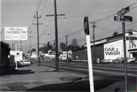
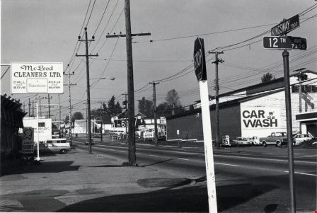
- Photograph shows view of Kingsway looking northwest from the corner of Kingsway and 12th Avenue.
- Repository
- City of Burnaby Archives
- Date
- October 20, 1976
- Collection/Fonds
- Burnaby Public Library Contemporary Visual Archive Project
- Physical Description
- 1 photograph : b&w ; 11 x 16 cm mounted on cardboard
- Description Level
- Item
- Record No.
- 556-543
- Access Restriction
- No restrictions
- Reproduction Restriction
- Reproduce for fair dealing purposes only
- Accession Number
- 2013-13
- Scope and Content
- Photograph shows view of Kingsway looking northwest from the corner of Kingsway and 12th Avenue.
- Media Type
- Photograph
- Photographer
- Ross, Martha
- Notes
- Scope note taken directly from BPL photograph description.
- 1 b&w copy negative : 10 x 12.5 cm accompanying
- Geographic Access
- Kingsway
- 12th Avenue
- Historic Neighbourhood
- Edmonds (Historic Neighbourhood)
- Planning Study Area
- Stride Avenue Area
Images

Nordic Centre
https://search.heritageburnaby.ca/link/archivedescription79734
- Repository
- City of Burnaby Archives
- Date
- November 1, 1976
- Collection/Fonds
- Burnaby Public Library Contemporary Visual Archive Project
- Description Level
- Item
- Physical Description
- 1 photograph : b&w ; 11 x 16 cm mounted on cardboard
- Scope and Content
- Photograph shows the Nordic Centre, located on 6th Street on the corner of 12th Avenue. A billboard advertising its services is attached to the side of the building. A few months after this photo was taken, the Nordic Centre was torn down.
- Repository
- City of Burnaby Archives
- Date
- November 1, 1976
- Collection/Fonds
- Burnaby Public Library Contemporary Visual Archive Project
- Physical Description
- 1 photograph : b&w ; 11 x 16 cm mounted on cardboard
- Description Level
- Item
- Record No.
- 556-407
- Access Restriction
- No restrictions
- Reproduction Restriction
- Reproduce for fair dealing purposes only
- Accession Number
- 2013-13
- Scope and Content
- Photograph shows the Nordic Centre, located on 6th Street on the corner of 12th Avenue. A billboard advertising its services is attached to the side of the building. A few months after this photo was taken, the Nordic Centre was torn down.
- Names
- Nordic Centre
- Media Type
- Photograph
- Notes
- Scope note taken directly from BPL photograph description.
- 1 b&w copy negative : 10 x 12.5 cm accompanying
- Photographers identified by surnames only: Carr and Vardeman
- Geographic Access
- 6th Street
- 12th Avenue
- Historic Neighbourhood
- East Burnaby (Historic Neighbourhood)
- Planning Study Area
- Second Street Area
Images

![Ramsey family, [1916] (date of original), copied [1999] thumbnail](/media/hpo/_Data/_Archives_Images/_Unrestricted/371/399-001.jpg?width=280)
Ramsey family
https://search.heritageburnaby.ca/link/archivedescription38301
- Repository
- City of Burnaby Archives
- Date
- [1916] (date of original), copied [1999]
- Collection/Fonds
- Burnaby Historical Society fonds
- Description Level
- Item
- Physical Description
- 1 photograph : b&w ; 20.2 x 25.3 cm print
- Scope and Content
- Photograph of seven members of the Ramsey family in the backyard of home at 12th Avenue and 4th Street. Identified are: standing (l to r): Eva Lillian Ramsey, Annie Ramsey (mother), and Queenie Ramsey. Seated (l to r): Dorothy Ramsey, Ernest Ramsey (twin to Dorothy), Gordon Ramsey and Jessie Ramse…
- Repository
- City of Burnaby Archives
- Date
- [1916] (date of original), copied [1999]
- Collection/Fonds
- Burnaby Historical Society fonds
- Subseries
- Ramsey family subseries
- Physical Description
- 1 photograph : b&w ; 20.2 x 25.3 cm print
- Description Level
- Item
- Record No.
- 399-001
- Access Restriction
- No restrictions
- Reproduction Restriction
- No known restrictions
- Accession Number
- BHS1999-19
- Scope and Content
- Photograph of seven members of the Ramsey family in the backyard of home at 12th Avenue and 4th Street. Identified are: standing (l to r): Eva Lillian Ramsey, Annie Ramsey (mother), and Queenie Ramsey. Seated (l to r): Dorothy Ramsey, Ernest Ramsey (twin to Dorothy), Gordon Ramsey and Jessie Ramsey.
- Names
- Ramsey, Annie
- Ramsey, Dorothy
- Ramsey, Ernest
- Ramsey, Eva Lillian
- Ramsey, Gordon
- Ramsey, Jessie
- Ramsey, Queenie
- Media Type
- Photograph
- Notes
- Title based on contents of photograph
- Geographic Access
- 4th Street
- 12th Avenue
- Historic Neighbourhood
- East Burnaby (Historic Neighbourhood)
- Planning Study Area
- Second Street Area
Images
![Ramsey family, [1916] (date of original), copied [1999] thumbnail](/media/hpo/_Data/_Archives_Images/_Unrestricted/371/399-001.jpg)
![Tramline tracks, [1905] thumbnail](/media/hpo/_Data/_BVM_Images/1990/199500100001.jpg?width=280)
Tramline tracks
https://search.heritageburnaby.ca/link/museumdescription3361
- Repository
- Burnaby Village Museum
- Date
- [1905]
- Collection/Fonds
- Burnaby Village Museum Photograph collection
- Description Level
- Item
- Physical Description
- 1 photograph : b&w ; 15 x 25.5 cm print
- Scope and Content
- Photograph of a British Columbia Electric Railway Company tramline track on Sixth Street and Twelfth Avenue. George Leaf's General Store, located at 7745 Sixth Street is visible on the left and Cliff's Car Factory located at 7730 Sixth Street is visible on the right. George Leaf's store burned down…
- Repository
- Burnaby Village Museum
- Collection/Fonds
- Burnaby Village Museum Photograph collection
- Description Level
- Item
- Physical Description
- 1 photograph : b&w ; 15 x 25.5 cm print
- Scope and Content
- Photograph of a British Columbia Electric Railway Company tramline track on Sixth Street and Twelfth Avenue. George Leaf's General Store, located at 7745 Sixth Street is visible on the left and Cliff's Car Factory located at 7730 Sixth Street is visible on the right. George Leaf's store burned down in 1913. The Car factory was established in 1902 and sometime in the 1920s, it became James Brookes Woodworking Plant.
- Subjects
- Transportation - Electric Railroads
- Buildings - Commercial - General Stores
- Buildings - Industrial - Factories
- Geographic Access
- 6th Street
- 12th Avenue
- Street Address
- 7730 6th Street
- 7745 6th Street
- Accession Code
- BV995.10.1
- Access Restriction
- No restrictions
- Date
- [1905]
- Media Type
- Photograph
- Historic Neighbourhood
- East Burnaby (Historic Neighbourhood)
- Planning Study Area
- Edmonds Area
- Notes
- Title based on contents of photograph
Images
![Tramline tracks, [1905] thumbnail](/media/hpo/_Data/_BVM_Images/1990/199500100001.jpg)